Hoywako Horapon
Jump to navigation
Jump to search
This article is a work in progress. Any information here may not be final as changes are often made to make way for improvements or expansion of lore-wise information about Gentu. Please comment on this article's talk page to share your input, comments and questions. Note: To contribute to this article, contact User:Philimania. |
Hoywakan State of Horapon 穂本ホ和光 (Horpongo) Hohon howakō (Alaricanisation) | |
|---|---|
Anthem: X | |
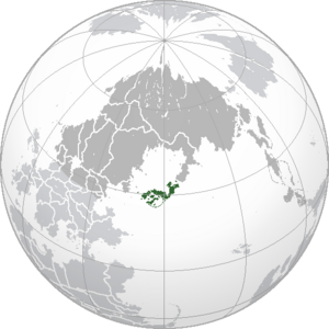
 Location of Horapon (green) in Hesterath (dark grey). | |
| Capital and largest city | Minakami |
| Official languages | Horpongo |
| Recognised regional languages | Kitsunese |
| Ethnic groups (2000) | 91.3% Horaponi 6.4% Kitsunefolk Others |
| Religion (2000) | 64.7% Kaoism 24.3% Tendoism 7.4% No religion 3.6 Others |
| Demonym(s) | Horaponi |
| Government | Unitary Hoywakist one-party state |
| Tano Masuhiro | |
| Kôzuke Doppo | |
| Legislature | National Congress |
| History | |
| c. 100 BCE | |
| 22 Marto 220 CE | |
| 26 Gunyana 1967–2 Pusper 1979 | |
• Hoywako Horapon established | 3 Pusper 1979 |
| 23 Hunyo 1982 | |
| Area | |
• Total | 405,352 km2 (156,507 sq mi) (X) |
• Water (%) | 0.27 |
| Population | |
• 1999 census | |
• Density | 228.4/km2 (591.6/sq mi) (X) |
| GDP (PPP) | 2000 estimate |
• Total | |
• Per capita | |
| GDP (nominal) | 2000 estimate |
• Total | |
• Per capita | |
| Gini (1999) | medium · X |
| HDI (2000) | high · X |
| Currency | Jin (銀/ǂ) (HRJ) |
| Time zone | MTS-5 (Horaponi Standard Time) |
| Date format | yyyy/mm/dd |
| Driving side | right |
| Calling code | +75 |
| Internet TLD | .hr |
Hoywako Horapon (Horpongo: 穂本ホ和光, Hohon howakō) formally the Hoywakan State of Horapon or simply as Horapon is an island country in Hesterath or more specifically in the Hesterath lowlands.
TBA


