
Halton Street

Halton Street is a main street in Lendert-with-Cadell running from east to west through the middle of Lendert, beginning at Knegate and running for eight miles or so until the outer suburban village of Halton-on-Wessert. The street is a main artery within the city and is lined with numerous notable buildings and landmarks.
Overview

Halton Street runs east-west, through the wards of Knightoward, Grenham, Polestreet, Edcheap, Hariotbay, Woolfields and Haltongate. It was named for the fact that it connects Lendert with the outer suburb of Halton-on-Wessert. However, the street changes names several times within the city limits. In fact, it begins as Knightoward Street,[1] which runs until its intersection with Meanstreet, whence it becomes Halton Street, until Edcheap when it becomes St. Peter's Street until Woolfields, when it reverts to Halton Street. Beyond Haltongate, it continues for approximately five and a half miles to Halton-on-Wessert.
Halton Street is a very important street in Lendert, being the main thoroughfare for traffic entering the city from the west, via Haltongate, and the east, via Knegate, which connects via Foots Cope and Saint Le Cross Street through Clertgate and Gilesgate to the north-eastern edge of the city. Halton Street is one of the busiest streets in Lendert-with-Cadell in both pedestrian traffic and vehicular traffic. Through the city, it is lined with half-timbered buildings in its middle section, with stone-faced Georgian buildings on the eastern and western ends. After a fire in the 1692 on the southern side of the western end, the street was widened considerably to around a chain, demolishing large stretches of houses along the southern sides of the two ends, and eating into the verge of St. Peter's Abbey. It is now lined with elm trees, with a small section of ash and lime in the east.
Landmarks
As Lendert-with-Cadell grew during the 18th and 19th centuries, Halton Street became one of the busiest streets in the city, with numerous public and commercial buildings located upon it.
For centuries it has been dominated by St. Peter's Abbey and Cathedral Church, located on the northern side of St. Peter's Street, which still to-day has the tallest tower in the city. Immediately to the west of the Abbey is Lendert's largest public park, Stole Park, which was originally a mediæval royal hunting forest. Before the street crosses the River Burm, the grand buildings of the Prince's Bank are located on the southern side of the street. Past the Burmbridge, Woolfields is a large intersection where originally the main livestock market of the city stood, which was moved during the 18th century to without the city walls. The western end of the street is dominated by commercial buildings and townhouses until Haltongate. A notable mediæval building is the Guildhall, the seat of the City Council.
To the east of St. Peter's Abbey is Edcheap, a large public market square which was built between 1748 and 1749 with the demolition of several buildings around and including the church of St. Mark in Stole. In its centre is the Hastican Column, erected in 1750 to commemorate the return of Hastica to Erbonian possession. From here, all distances from Lendert are measured. The eastern end of the street is a major shopping and cultural area, with numerous upmarket food, retail and merchandise shops such as Johnhurst's Arcade, as well as the Lendert Museum, Lord Steuard's Theatre and the Queen's Opera House.

The Guildhall.
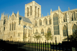
St. Peter's Abbey.

Embassy of Hindia Belanda.

Johnhurst's Arcade.

Edcheap.


Occasions

Halton Street is a principal location for numerous state and ceremonial processions and parades. The Sovereign, when he opens Parliament, travels along Halton Street from St. Michael'sgate Palace, turning left at Edcheap up Lophert Street towards the Castle of Lerdenstone. Its wide breath also means it is commonly used for military parades. Along the street are guard posts every 330 feet, manned by guardsmen of the Royal Army. The regular changing of the guard along the street is a well-known sight. Halton Street also plays host to many civic parades, including the annual Lord Mayor's Michaelmas Parade, the Shrove Tuesday parade, and the massive King's Day procession on Whit Monday, which culminates in a massed parade on Edcheap around the Hastican Column in the presence of the King.
Transport
Halton Street is well served by public transport. The No. 3, 4, 5 and 8 and 45 trams run down the street, and many lines also intersect it. It is serviced by four underground railway stations, at Haltongate, Woolfields, St. Peter's Cathedral, and Mean Street. At its eastern end, there are two mainline termini, Istfields railway station and Footscopse railway station of the Lendert, both operated by the City and Counties Railway. At its western end, Haltongate railway station is the largest in the city, operated by the Great North Western Railway.
| History |  | ||||||||
|---|---|---|---|---|---|---|---|---|---|
| Geography |
| ||||||||
| Government |
| ||||||||
| Society |
| ||||||||
This page is written in Erbonian English, which has its own spelling conventions (colour, travelled, centre, realise, instal, sobre, shew, artefact), and some terms that are used in it may be different or absent from other varieties of English. |
- ↑ Knightoward Street was originally Knight Ward Street, deriving from the name of the eastern gate, Knightgate, which has mutated to Knegate. The name of ward is a backformation from the name of the street.