Idisamo: Difference between revisions
mNo edit summary |
mNo edit summary |
||
| (One intermediate revision by the same user not shown) | |||
| Line 17: | Line 17: | ||
| map_alt = | | map_alt = | ||
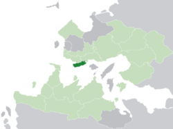
| map_caption = '''Idisamo''' (dark green) in the [[Trellin|Kingdom of Trellin]] (light green) | | map_caption = '''Idisamo''' (dark green) in the [[Trellin|Kingdom of Trellin]] (light green) | ||
| subdivision_type = [[:Category:Nations of the Trellinese Empire|Nation]] | | subdivision_type = [[:Category:Nations of the Trellinese Empire|Nation]] | ||
| subdivision_name = [[Trellin]] | | subdivision_name = [[Trellin]] | ||
| Line 40: | Line 35: | ||
| leader_name = | | leader_name = | ||
| unit_pref = Metric | | unit_pref = Metric | ||
| area_magnitude = <!-- <ref> </ref> --> | | area_magnitude = <!-- <ref> </ref> --> | ||
| area_note = | | area_note = | ||
| Line 53: | Line 42: | ||
| area_blank2_title = | | area_blank2_title = | ||
<!-- square kilometers --> | <!-- square kilometers --> | ||
| area_total_km2 = | | area_total_km2 = 12,393.20 | ||
| area_land_km2 = | | area_land_km2 = | ||
| area_water_km2 = | | area_water_km2 = | ||
| Line 61: | Line 50: | ||
| area_blank1_km2 = | | area_blank1_km2 = | ||
| area_blank2_km2 = | | area_blank2_km2 = | ||
| elevation_m = | | elevation_m = | ||
| population_footnotes = | | population_footnotes = | ||
| Line 83: | Line 59: | ||
| timezone1 = | | timezone1 = | ||
| utc_offset1 = | | utc_offset1 = | ||
| postal_code_type = | | postal_code_type = | ||
| postal_code = | | postal_code = | ||
| Line 90: | Line 64: | ||
| area_code = 029 | | area_code = 029 | ||
| iso_code = | | iso_code = | ||
}} | }} | ||
'''Idisamo''' (pronounced {{wp|Help:IPA_for_English|/ɪdɪˈsæmoʊ/}}), officially the '''Margraviate of Idisamo''' ([[Trellinese language|Trellinese]]: ''Metlan | '''Idisamo''' (pronounced {{wp|Help:IPA_for_English|/ɪdɪˈsæmoʊ/}}), officially the '''Margraviate of Idisamo''' ([[Trellinese language|Trellinese]]: ''Metlan Idisamoka''), is a province of the [[Trellin|Trellinese Empire]]. It is the ninth-least populous province in Trellin and [[Hysera]] and the eighth smallest by total area. Idisamo is bounded to the north by [[Alyrum]] and [[Pelna]], to the west by the [[Straits of Jajich]] and to the south and east by the [[Sea of Velar]]. Its landmass of approximately {{convert|12400|sqkm|sqmi}} is home to over 5 million people. The largest city and seat of provincial government is [[Betria]], near the Pelnan border. | ||
Idisamo | Idisamo was settled as a territory of Alyrum in the second century BC. When the territory was granted the status of margraviate in the first century AD, it did not then include the area of [[East Idisamo]], which then belonged to Pelna, including the important city of Betria on the north bank of the Rastanar.<!--rasatig den-arim, rich in fish--> The [[Pelnan War of Secession]] in the fifth century saw Trellin lose the entirety of what is now Pelna, but Betria and East Idisamo remained under imperial control. Betria has belonged to Idisamo since this time. | ||
A large, low plateau defines Idisamo's geography, with the province's coastline consisting mainly of low cliffs broken by shingle | A large, low plateau defines Idisamo's geography, with the province's coastline consisting mainly of low cliffs broken by beaches composed of shell and shingle. Until the 1300s the plateau was covered almost entirely in dense rainforest, but much of this was then cleared for agriculture, which is an important economic activity in the province. Rich silver deposits can be found on the large western peninsula, and these have been mined for centuries by local peoples. | ||
{{Navbox Subdivisions of the Trellinese Empire}} | {{Navbox Subdivisions of the Trellinese Empire}} | ||
[[Category:Provinces of Trellin]][[Category:Trellin]][[Category:Astyria]] | [[Category:Provinces of Trellin]][[Category:Trellin]][[Category:Astyria]] | ||
Latest revision as of 22:40, 26 December 2023
Idisamo | |
|---|---|
 Idisamo (dark green) in the Kingdom of Trellin (light green) | |
| Nation | Trellin |
| Capital | Betria |
| Area | |
| • Total | 12,393.20 km2 (4,785.04 sq mi) |
| Population (2013) | |
| • Total | 4,974,571 |
| • Density | 400/km2 (1,000/sq mi) |
| Demonym | Idisamoan |
| Area code(s) | 029 |
Idisamo (pronounced /ɪdɪˈsæmoʊ/), officially the Margraviate of Idisamo (Trellinese: Metlan Idisamoka), is a province of the Trellinese Empire. It is the ninth-least populous province in Trellin and Hysera and the eighth smallest by total area. Idisamo is bounded to the north by Alyrum and Pelna, to the west by the Straits of Jajich and to the south and east by the Sea of Velar. Its landmass of approximately 12,400 square kilometres (4,800 sq mi) is home to over 5 million people. The largest city and seat of provincial government is Betria, near the Pelnan border.
Idisamo was settled as a territory of Alyrum in the second century BC. When the territory was granted the status of margraviate in the first century AD, it did not then include the area of East Idisamo, which then belonged to Pelna, including the important city of Betria on the north bank of the Rastanar. The Pelnan War of Secession in the fifth century saw Trellin lose the entirety of what is now Pelna, but Betria and East Idisamo remained under imperial control. Betria has belonged to Idisamo since this time.
A large, low plateau defines Idisamo's geography, with the province's coastline consisting mainly of low cliffs broken by beaches composed of shell and shingle. Until the 1300s the plateau was covered almost entirely in dense rainforest, but much of this was then cleared for agriculture, which is an important economic activity in the province. Rich silver deposits can be found on the large western peninsula, and these have been mined for centuries by local peoples.

