Melasia: Difference between revisions
The ©rusader (talk | contribs) |
The ©rusader (talk | contribs) mNo edit summary |
||
| Line 135: | Line 135: | ||
[[Category:Melasia]] | [[Category:Melasia]] | ||
[[Category:Countries of Aurorum]] | [[Category:Countries of Aurorum]] | ||
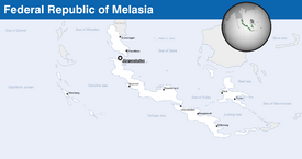
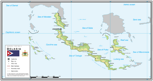
'''Melasia''', officially the '''Federal Republic of Melasia''' ({{wp|German language|Hesurian}}: ''Bundesrepublik Melasien''), is a {{wp|sovereign}} country on the continent of [[Melasia and Mavronesia]]. At | '''Melasia''', officially the '''Federal Republic of Melasia''' ({{wp|German language|Hesurian}}: ''Bundesrepublik Melasien''), is a {{wp|sovereign}} country on the continent of [[Melasia and Mavronesia]]. At 981,186.1 square kilometres (378,838.1 sq mi), Melasia is the nth largest country in the [[Aurorum (region)|world]] by area, and the xth most populous, with slightly below 23 million people living in the country as of 2019. Melasia's {{wp|capital}}, [[Jürgenshafen]], is the largest {{wp|city}} in the country and a major port on the {{wp|sea}} route between Eastern [[Pamira]] and [[Berea]], situated in the König Lukas Strait between the Manatan Sea and the Sea of Saba; other major cities include [[Braunfliess]], Grünshagen, Eriksburg, Pulau, [[Stoschmund]], Neukirch and Unionshafen. The territory of the country is situated within the BST +8 to +9 time zones. | ||
Melasia consists of 5 major islands forming the subconstinent of Melasia within Melasia and Mavronesia, as well as up to 350 small and {{wp|volcanic islands}} in the Caroline Sea, Manatan Sea, Sea of Saba, Sea of Pulau, Reef Sea and Ludwig Sea. The Melasian subcontinent is a result of past volcanic activity on the Melasian tectonic plate, while the smaller Caroline Islands archipelago is situated on the border between the Melasian, Equatorian and Notosian tectonic plates and is one of the most volcanically and seismically active regions in the world. The seismological activity leads to frequent {{wp|earthquakes}}, {{wp|tsunamis}} and {{wp|volcanic erruptions}}, especially in the Caroline Sea. This area is considered one of the most dangerous ones in the world. The territory of the country is located close to the {{wp|equator}} and is relatively flat, which makes it exposed to {{wp|monsoons}}. Almost all of the northern territory of the country is covered by {{wp|rainforests}} and is located within the {{wp|subtropical climate|subtropical}} rainforest climate region, while the southern islands of the Melasian chain, including the southern portion of König Lukas Island, New Jusland Island and the König Ludwig islands experience more arid climate and even some small deserts can be found within the islands. | Melasia consists of 5 major islands forming the subconstinent of Melasia within Melasia and Mavronesia, as well as up to 350 small and {{wp|volcanic islands}} in the Caroline Sea, Manatan Sea, Sea of Saba, Sea of Pulau, Reef Sea and Ludwig Sea. The Melasian subcontinent is a result of past volcanic activity on the Melasian tectonic plate, while the smaller Caroline Islands archipelago is situated on the border between the Melasian, Equatorian and Notosian tectonic plates and is one of the most volcanically and seismically active regions in the world. The seismological activity leads to frequent {{wp|earthquakes}}, {{wp|tsunamis}} and {{wp|volcanic erruptions}}, especially in the Caroline Sea. This area is considered one of the most dangerous ones in the world. The territory of the country is located close to the {{wp|equator}} and is relatively flat, which makes it exposed to {{wp|monsoons}}. Almost all of the northern territory of the country is covered by {{wp|rainforests}} and is located within the {{wp|subtropical climate|subtropical}} rainforest climate region, while the southern islands of the Melasian chain, including the southern portion of König Lukas Island, New Jusland Island and the König Ludwig islands experience more arid climate and even some small deserts can be found within the islands. | ||
Revision as of 17:31, 31 July 2021
Federal Republic of Melasia Bundesrepublik Melasien (Hesurian) | |
|---|---|
| Motto: Stärke und Einheit (Hesurian) Strength and unity | |
| Anthem: Voran, du freien Leute!
Forward, you free people! | |
 | |
| Capital and largest city | Jürgenshafen |
| Official languages | Hesurian |
| Recognised national languages | See National languages in Melasia |
| Ethnic groups (2018) | TBD |
| Religion | Various
|
| Demonym(s) | Melasian |
| Government | Federal constitutional parliamentary republic |
• President | Gustaf Sorbo |
• Prime Minister | Erik Brandt |
| Legislature | Parliament |
| Senate | |
| House of Representatives | |
| Independence from Mascylla | |
| 31 January 1904 | |
| 13 May 1921 | |
| 10 May 1941 – 5 September 1943 | |
• Current Constitution | 11 November, 1969 |
| Area | |
• Total | 981,186.1 km2 (378,838.1 sq mi) |
• Water (%) | 3.8 |
| Population | |
• September 2020 estimate | 22,872,511 (42) |
• June 2019 census | 22,983,117 |
| GDP (PPP) | 2019 estimate |
• Total | $1.31 trillion |
• Per capita | $56,915 |
| GDP (nominal) | 2019 estimate |
• Total | $1.26 trillion |
• Per capita | $54,722 |
| Gini (2018) | 34.7 medium |
| HDI (2017) | 0.921 very high |
| Currency | krona (Kr) |
| Time zone | AST +8 to +9 |
| Date format | dd-mm-yyyy |
| Driving side | right |
| Calling code | +375 |
| ISO 3166 code | ME |
| Internet TLD | .me |
Melasia, officially the Federal Republic of Melasia (Hesurian: Bundesrepublik Melasien), is a sovereign country on the continent of Melasia and Mavronesia. At 981,186.1 square kilometres (378,838.1 sq mi), Melasia is the nth largest country in the world by area, and the xth most populous, with slightly below 23 million people living in the country as of 2019. Melasia's capital, Jürgenshafen, is the largest city in the country and a major port on the sea route between Eastern Pamira and Berea, situated in the König Lukas Strait between the Manatan Sea and the Sea of Saba; other major cities include Braunfliess, Grünshagen, Eriksburg, Pulau, Stoschmund, Neukirch and Unionshafen. The territory of the country is situated within the BST +8 to +9 time zones.
Melasia consists of 5 major islands forming the subconstinent of Melasia within Melasia and Mavronesia, as well as up to 350 small and volcanic islands in the Caroline Sea, Manatan Sea, Sea of Saba, Sea of Pulau, Reef Sea and Ludwig Sea. The Melasian subcontinent is a result of past volcanic activity on the Melasian tectonic plate, while the smaller Caroline Islands archipelago is situated on the border between the Melasian, Equatorian and Notosian tectonic plates and is one of the most volcanically and seismically active regions in the world. The seismological activity leads to frequent earthquakes, tsunamis and volcanic erruptions, especially in the Caroline Sea. This area is considered one of the most dangerous ones in the world. The territory of the country is located close to the equator and is relatively flat, which makes it exposed to monsoons. Almost all of the northern territory of the country is covered by rainforests and is located within the subtropical rainforest climate region, while the southern islands of the Melasian chain, including the southern portion of König Lukas Island, New Jusland Island and the König Ludwig islands experience more arid climate and even some small deserts can be found within the islands.
It is confirmed that various tribes have crossed the strait between Pamira and Melasia as early as 2200 BCE. The first documented civilizations date from the 18000 BCE. As suggested by its geographical location, the islands of modern-day Melasia played a vital role in ancient and medieval naval trade between the east and the west. Melasian tribes were known as excellent sailors, and evidences of their expeditions can be found around the Melasian and even Mavronesian archipelago and as far as southern Pamira and the Caroline Islands. During the Middle ages the area was heavily influenced by various Pamiran nations like Kenlong. Until the 19th century the area was never unified under one flag, with parts of the islands in strategic locations being owned by more powerful Pamiran empires, with the rest of modern-day Melasia being divided among various feudals, tribal alliances and isolated communities.
The islands were first discovered by Bereans in the 17th century. The first colonial empire to aquire full control over the territory of modern-day Melasia was Mascylla in 1804. After a series of conflicts between the Berean colonizers and the local warlords, the Crown Colony of Mascyllary Melasia was formed in 1823. Melasia as a concept arose after the Great War, when the area experienced a rise of national identity among its native peoples. Due to rising internal tensions, the colony was given increased autonomy from its metropole following a number of reforms between 1905-1919, and declared independence in 1929, however, remained highly dependent on its former metropole. In the 1930s, Melasian leaders attempted to gain complete independence from Mascylla and to perform independent international politics, creating stronger ties with Cuthland-Waldrich in Berea. This resulted in the Melasian Crisis and armed conflicts in both Berea and in Melasia. The country managed to gain polito-economic autonomy from Mascylla as a result of the war, an authoritarian regime was established for the next several decades. Following a severe economical crisis and unsuccessful political reforms in the late 1960s, the country experienced a revolution in 1967, when its government was disbanded and President Salemon Linberg was imprisoned. Melasia constructed a stable liberal democratic political system over the course of forty years, slowly rebuilding its economy. Today Melasia is a federation consisting of 6 states and 4 autonomous territories, including the disputed Walter Island Chain in the Sea of Saba.
The economy of Melasia is one of the largest in Pamira and the largest on the continent of Melasia and Mavronesia. It is ranked nth by nominal GDP per capita. Melasia is in top positions in quality of life, human development and income per capita. The country is widely renowned for its freedom of speech, high democracy index, and protection of human rights. Jürgenshafen, the country's capital, is the fifth city in the global livability survey. Melasia has a modern service-based economy. Its primary exports include consumer electronics, IT software and hardware, automobiles, heavy industrial machinery, and natural resources, most notably rubber, with other important resources being petroleum, palm oil, lignite and polymetal ore. The country is a major tourist destination, and tourism is a major part of its current economy. Melasia is a member of the Assembly of Nations, !CPIS and the Mavronesian Council for Economic Development.
Etymology
The etymology of the name Melasia has two possible origins. According to Mascyllary linguists of the twentieth century, the name most probably was derived from the Erytheric words μέλος (melos), meaning melody, and νῆσος (nesos), meaning islands, to form the name "the island of melodies", probably due to the songs of the native tribes.
According to another theory, the ancient name of one of the islands was derived from the Malayam word മുല്ലപ്പൂ (mullappu), meaning jasmine, which slowly evolved into melati. When the Dulebian colonists arrived to the islands in the 19th century they would eventually use the word melati as name for the native tribes. By adding the Greek word νῆσος (nesos), meaning island, they formed the name Melasia, "islands of the Melati".
History
Part of a series on the |
||||||||||||||||
|---|---|---|---|---|---|---|---|---|---|---|---|---|---|---|---|---|
| History of Melasia | ||||||||||||||||
  | ||||||||||||||||
|
||||||||||||||||
| Timeline | ||||||||||||||||
Early history
-
-
-
-
-
-
-
-
-
-
-
-
-
-
-
-
-
-
-
-
-
abc
Late middle ages
Colonial period
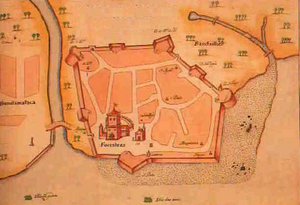
The first contact between the Melasian states and the Bereans happened in 1538, when the Lavish explorer Antônio Bragança discovered the Caroline Island chain and later established contact with the kings on the island of Manatan. In 1567, after a brief conflict between the Lavish and the Sultanate of Pulau, an expeditionary corps led by Francisco Solimões captured the southern bank of the current Strait of Jurgenshafen and established the fort of Palmeiras. In the next 100 years, several other Berean states established trading outposts on the island of Manatan and in southern Kenlong, including Cuthland and Falland. Following the Cuthish Revolution and the Unification of Mascylla, the Cuthish colonial possessions were transferred to the newly-formed Mascyllary Kingdom.
Following the Mascyllo-Lavish Treaty of 1799, Mascylla received all Lavish and former Cuthish colonial possessions in Melasia, leaving Mavronesia to Lavaria. The Mascyllary colonial administration led an agressive expansion into the region, subjugating the small feudal states and fighting a number of armed conflicts against the Empire of Kenlong, which was the hegemon in the region. In contrast with most of its other colonies, in Melasia the Mascyllary metropoly allowed the loal warchiefs to retain control of their possessions as long as they remain under the protectorate of the metropoly itself. By 1823, Mascylla managed to gain control over all of the modern-day Melasia, as well as a portion of Kenlong. The Empire of Melasia was established the same year as an unitary state, consisting of three states under direct Mascyllary rule and a number of so-called princely states, which were vassals of Mascylla. On paper, the state acted as a realm being ruled by the Emperor of Mascylla via the Viceroy of Melasia. Under the colonial administartion, the country lost its economic independence and only exported raw materials to the metropoly in Berea. The Empire of Melasia also lacked its own armed forces, having to rely on the Mascyllary navy to protect its sovereignity. On the other hand, Melasia benefitted from the technological and social advances of Berea: being extremely resource-rich, the country fairly early compared to other colonies received a network of railroads, paved roads and major harbours. Education became widespread in the second part of the 19th century. The first telegraph cable was set between Jurgenshafen (former Palmeiras) and Braunfliess.
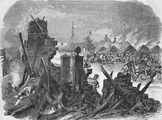
Numerous attempts of the colonial administration to perform social reforms of the native population were met with severe disapproval, culminating with the widespread unrest of 1901-1903, known as the Melasian Uprising. While the rebellion was successfully put down by 1903, its main result was the reformation of the country. The former colonial institutes were dissolved, while the country itself was transformed into a federation of 36 small states and received its first constitution and a bicameral parliament, becoming known as the Federated Melasian States. However, the country was still under strict rule of the Mascyllary metropole. Former members of the colonial administration received high-ranking posts in the government of the federation and all seats in the Melasian Senate, the upper house of the parliament. The Viceroy of Melasia became the Governor-General. The Governor-General's power was still significant, as they had to form the Senate, and no bill accepted by both the lower and upper house of the parliament could be accepted without their approval. Beyond that, the Governor-General had the right to dissolve the Council of States (the lower house of the parliament). Despite receiving nominal right to govern itself, the Federated Melasian States did not gain the status of a Dominion, remaining under almost full control of its former metropole. The Federation participated in the Great War on the side of the Armala coalition and fought actively both in Berea and on home territory. After the war, the country was hit by a powerful financial crisis and saw a drastic drop in foreign investment, which eventually let to a massive protest activity, mainly among the white population and the middle class in the country. A number of fruitless economic reforms performed under Mascyllary supervision and continuing social unrest gave the rise to a radical far-right party in the country in the late 1920s led by Wilhelm Keller. After a series of negotiations, Mascylla and the Federated Melasian States eventually signed the Fleicher Accords that gave the state a full autonomy in 1929. The same accord disbanded the Mascyllary institutes in the country and restructured it to a unitary presidential republic, with Wilhelm Keller becoming the first elected president in 1930.
Republican period and the Melasian Crisis


