Cavala: Difference between revisions
Philimania (talk | contribs) m (→Government) |
Philimania (talk | contribs) m (→Geography) |
||
| Line 165: | Line 165: | ||
[[File:Climate Map.png|left|thumb|Climate map of Cavala.]] | [[File:Climate Map.png|left|thumb|Climate map of Cavala.]] | ||
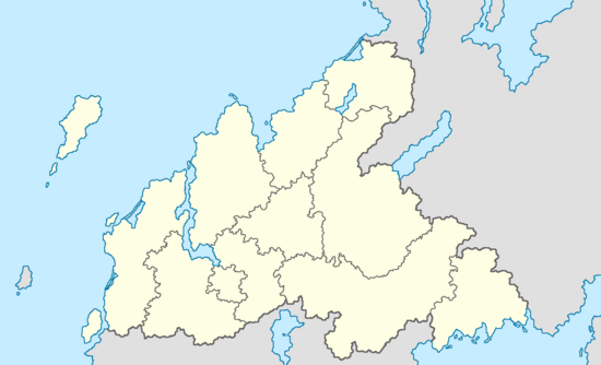
{{Cavala Province Labelled Map}} | |||
The physical geography of Cavala consists of a terrain that is mostly flat plains or gently rolling hills in the north, east and west; and mountainous in the south which includes the [[Surmonté mountains]]. Cavala has a total size of 422,633 km<sup>2</sup> (163,180 sq mi). It is the XXX largest country in Gentu by area and the XXX largest in Oranland. The tallest point in Cavala is [[Mount Sudist]] standing at 1,391 metres. | The physical geography of Cavala consists of a terrain that is mostly flat plains or gently rolling hills in the north, east and west; and mountainous in the south which includes the [[Surmonté mountains]]. Cavala has a total size of 422,633 km<sup>2</sup> (163,180 sq mi). It is the XXX largest country in Gentu by area and the XXX largest in Oranland. The tallest point in Cavala is [[Mount Sudist]] standing at 1,391 metres. | ||
| Line 189: | Line 190: | ||
=== Administrative divisions === | === Administrative divisions === | ||
The 2nd Republic of Cavala is divided into 12 provinces. The provinces are further subdivided into [[Counties of Cavala|40 counties]]. The counties are in turn, subdivided into [[Conteurs of Cavala|171 conteurs]]. The provinces, counties and conteurs are possess local assemblies as well as an executive. | The 2nd Republic of Cavala is divided into 12 provinces. The provinces are further subdivided into [[Counties of Cavala|40 counties]]. The counties are in turn, subdivided into [[Conteurs of Cavala|171 conteurs]]. The provinces, counties and conteurs are possess local assemblies as well as an executive. | ||
Revision as of 05:57, 13 May 2022
This article is a work in progress. Any information here may not be final as changes are often made to make way for improvements or expansion of lore-wise information about Gentu. Please comment on this article's talk page to share your input, comments and questions. Note: To contribute to this article, contact User:Philimania. |
2nd Republic of Cavala 2e République de Cavala (Cavalan) | |||||||
|---|---|---|---|---|---|---|---|
| Motto: "Vive le Cavala" "Long live Cavala" | |||||||
| Anthem: XXX | |||||||
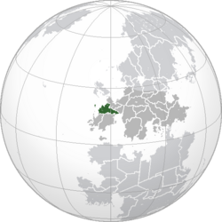 Location of Cavala (Green) in Oranland (Dark Grey) | |||||||
| Capital | Godfrey | ||||||
| Largest city | Moreux | ||||||
| Official language and national language | Cavalan | ||||||
| Ethnic groups (1998) | 97.4% Cavalan 2.6% Others | ||||||
| Religion (1999) | 63% Terranity 17.8% Hafan 13.1% No religion 6.1 Others | ||||||
| Demonym(s) | Cavalan | ||||||
| Government | Unitary semi-presidential republic | ||||||
| Mathéo Vasseur | |||||||
| Alberte Jacquinot | |||||||
| Legislature | Parliament | ||||||
| Senate | |||||||
| Assembly of Deputes | |||||||
| Establishment | |||||||
| 12 Kunnen 1812–28 Gunyana 1816 | |||||||
• Cavalan Republic established | 1 Okjatab 1860 | ||||||
• Cavalan Empire established | 27 Marto 1865 | ||||||
| 31 Tebax 1948 | |||||||
• Current constitution and 2nd Republic | 2 Gunyana 1948 | ||||||
| Area | |||||||
• Total | 422,633 km2 (163,180 sq mi) (XXX) | ||||||
• Water (%) | 0.85% | ||||||
| Population | |||||||
• 1987 estimate | |||||||
• 1994 census | |||||||
• Density | 114.5/km2 (296.6/sq mi) (XXX) | ||||||
| GDP (PPP) | 1998 estimate | ||||||
• Total | |||||||
• Per capita | |||||||
| GDP (nominal) | 1999 estimate | ||||||
• Total | |||||||
• Per capita | |||||||
| Gini (1996) | low (XXX) | ||||||
| HDI (1994) | very high (XXX) | ||||||
| Currency | Bilet (Ƀ) (BLT) | ||||||
| Time zone | MTS-9 (West Oranland Time) | ||||||
| Date format | dd-mm-yyyy | ||||||
| Driving side | right | ||||||
| Calling code | XXX | ||||||
| Internet TLD | .ca | ||||||
| |||||||
Cavala, officially the 2nd Republic of Cavala (Cavalan: 2e République de Cavala), is a country in western Oranland. It also has overseas regions and territories in the Domicas and the Nullaric. Its main territories extends from the XXX river to the Ingentric and from the Zestoric to the Neragese Channel; overseas territories include Cavalan Iolana in Flonesia and many islands in South and North. Cavala borders XXX to the north, XXX and XXX to the south, and XXX to the east. Its 12 provinces span a combined area of 422,633 km2(163,180 sq mi) and over 48 million people (as of 1994). Cavala is a unitary semi-presidential republic with its capital in Godfrey, the country's largest city and main cultural and commercial centre; other major urban areas include Moreux, Port-de-Gagnon, XXX, XXX, and XXX.
- Brief history stuff blah blah blah
Cavala retains its centuries-long status as a global centre of art, science and philosophy. It is the world's leading tourist destination, receiving over 102 million foreign visitors in 1998. Cavala is a developed country with the world's XXX-largest economy by nominal GDP and XXX-largest by PPP; in terms of household net income, it ranks XXX in the world. Cavala performs well in international rankings of education, health care, life expectancy and human development. It remains a great power in global affairs, being an official state with nuclear weaponry. Cavala is a founding and leading member of the Union of Realms as well as a key member of the Alfed-Riverend Defence Organization (ARDO) and the XXX.
Etymology
TBA
History
Prehistory
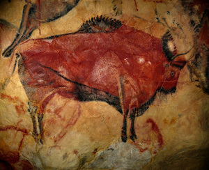
The earliest trace of human civilization in modern day Cavala dates back to around 2.2 million years ago. Early hominids led a nomadic hunter-gatherer life. Cavala has a large number of decorated caves from the Vetuslithic Age, including one of most well preserved, XXX. After strong demographic and agricultural development between the 6th and 3rd millennia BCE, metallurgy appeared at the end of the 3rd millennium, initially working gold, copper and bronze, as well as later iron. Cavala has numerous megalithic sites from the Novalithic Age, most notable being the dense Fortuna stones site (approximately 3,400 BCE).
Ancient Era & Alarican control
Around the 23rd century BCE, the Calidum Empire founded the colony of Ganoia (present-day Port-de-Gagnon), on the shores of the Zestoric Sea. This makes it Cavala's oldest city. Around the same time, the Dordon people begun to settle the region.
In 1100 BCE, Calidum colonies in modern day Cavala were abandoned due to constant attacks by the Dordon people. At the same time, the Veragese people from the Hesterlon Peninsula migrated north gradually spreading through the rest of the country between the 11th and 5th century BCE and driving the Dordons north to modern day XXX.
Around the 5th and 4th century BCE, small kingdoms would appear throughout the region the most well known of which are the kingdoms of Moredum, Hydorun, and Beslius.
In 50 BCE, most former Calidum colonies in Cavala were claimed by the Pylosan Empire. However, Pylosan rule was shortlived, as the conclusion of the 1st, later 2nd Zestoric War saw the assimilation of many Pylosan colonies in the region by the Alaricans. From 4 CE, to 300 CE, the Alarican Empire conquered the rest of modern day Cavala. Many cities were founded during Alarican control, including Moreum (present-day Moreux), which is considered the capital of the region. These cities were built in traditional Alarican style, with aqueducts, theatres, gymnasiums, and bath complexes. Some cities also included libraries and shops, and marketplaces. The Veragese mixed with Alarican settlers and eventually adopted Alarican culture and Alarican speech (XXX, from which the Cavalan language and culture evolved).
From the 4th to early 5th century CE, the Empire faced many challenges in the form of attacks from native Oranland tribes from the northern region of Oranland. These attacks eventually led to the downfall of the empire in 500 CE as many tribes migrated and settled on former Alarican territory replacing them by the so-called barbarian kingdoms.
TBA
Middle Era and Early Modern Age
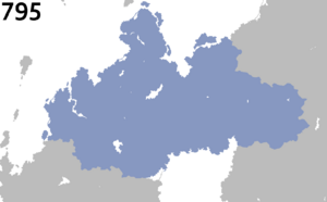
Around 670 CE, the Ressen Empire emerges under the reign of Wagner I. He conquering huge swaths of territory stretching from modern day XXX and XXX. However, the empire did not survive after the death of Wagner II in 795. Under the Treaty of Helmsburg, the empire was divided between Wagner's 2 sons, with East Ressen going to Wagner III, and West Ressen to Charles I.
During the 7th and 8th century CE, West Ressen became a very decentralised state: the nobility's titles and lands became hereditary, and the authority of the king became more religious than secular and thus was less effective and constantly challenged by powerful noblemen. Thus, the Veragese Collective was established: a group of unified principalities that acted as one large nation. Over time, some of the principalities would grow so powerful that they often posed a threat to the king. For example, after the War of the Long Knives in 1006, Graham the Great added "King of Sotha" to his titles, becoming both the subject to (as Prince of Lombard) and the equal of (as king of Sotha) the king of Veragon, creating recurring tensions.
In 921 CE, Terranity was formed as a religion that promoted peace in the Veragese Collective as well as an alternative to Hafanism. As war was frequent in the collective, the religion appealed to the lower class population as they were the ones who had to suffer the most during the conflicts. The religion was expectedly despised by the upper class and some of the middle class. Throughout the Middle Era, Terranists would be heavily persecuted in Veragon. Like the rest of Oranland, the Veragese Collective was struck by the Great Plague; half of the 21 million population of the Veragese Collective died.
The Oranland War in the Veragese Collective saw many major battle including the Battle of Bruno, Battle of Godfrey, and the Battle of Egon. The Resurgence of Terranity which begun in 1320 saw the conversion of many rulers in the collective, the first one to do so being Penrod von Serida. The Great Enlightenment in the Veragese Collective saw a spectacular cultural development and the first standardisation of the Cavalan language, which would become the language of Europe's aristocracy.
TBA
Revolutionary Cavala
The Industrial Revolution in Oranland brought about the first factory in 1768, which was a textile factory. Over the next few decades, more and more factories popped up in the countryside resulting in the creation of new settlements which in turn led to the foundation of a more complex social hierarchy. However, these new changes also introduced a larger wealth gap throughout Gentu. Resulting in the rich getting richer and the poor getting poorer. Because of this, the new Volkist ideology developed in the southern principalities of the Veragese Collective.
This would lead to the Cavalan Revolutionary War in 1812. Inspired by the Chokaw's war, they united the southern Veragese principalities into the Cavalan Republic in 1816. Wary of Cavala's rapid expansion, the Anti-Cavalan Coalition led by the Principality of Serida and Seronia-Sotha was formed in Kunnen of 1816. This prompted the Great Coalition War in 1817 which ended in 1820 in a Decisive Cavalan victory, managing to aquire 2 colonies in Flonesia and 4 in the Domicas.
TBA
19th century
In 1848, war between Cavala and Paqueonia would break out resulting in the Peninsular War which ended in 1852 with the release of Paloa and some minor border changes between Cavala and Paqueonia.
In 1871, 2 years after the last major war, the Grande Vitrine was held in Cavala. It was an international exhibition which took place in XXX, XXX, from 2 Kunnen to 16 Pulungana, 1871. It was the first in a series of World's Fairs, exhibitions of culture and industry that became popular in the 19th and early 20th century. Modern historians such as XXX believe that without the emergence of World's Fairs, then the Contemporary Age would have been drastically different then what we recognise.
TBA
Contemporary Age
The early 20th century challenged the faltering Cavalan monarchy with a number of existential and social crises. Frustrated by parliament’s inability to solve the economic and political issues plaguing the empire, General Néo Couvreur establishes a military dictatorship in Hunyo of 1895 with the backing of King José VI, Néo Couvreur’s regime alleviated unemployment and improved infrastructures. However, his regime did not last long as a train accident in Memesa of 1900 resulted in his demise at St Roteaux Hospital in Godfrey the same month. A conservative win in the 1900 Cavalan general election heralded the “L’Années Sombre”, marked by political, violence, and paramilitary action. In 1903, a coup occurred, replacing the Conservative Party with the Fierté Nationale under Jean-Pierre Lazard. After fending off counter-coups, the situation stabilised.
In 1918, the Great War begun and blah blah blah
TBA
Geography
Physical geography and Climate
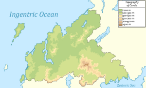
The physical geography of Cavala consists of a terrain that is mostly flat plains or gently rolling hills in the north, east and west; and mountainous in the south which includes the Surmonté mountains. Cavala has a total size of 422,633 km2 (163,180 sq mi). It is the XXX largest country in Gentu by area and the XXX largest in Oranland. The tallest point in Cavala is Mount Sudist standing at 1,391 metres.
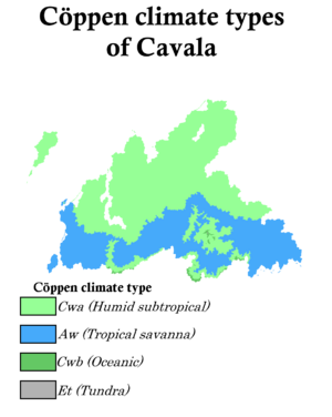
Cavala is relatively large, so the climate is not uniform, giving rise to the following climate nuances:
- The oceanic climate (Cfb) is found around the coasts of the country and in most inland regions. Summers are pleasantly warm and wet, while winters are cool and damp.
- The humid subtropical climate (Cfa) is found in the interior plains and at low mountainous regions of Cavala. Summers are hot and humid, while winters are cool to mild.
- The warm-summer humid continental climate (Dfb) is found in all the mountainous regions of the southern half of Cavala between 300 and 500 metres. Summers are pleasantly warm and wet, while winters are very cold and snowy.
Climate change in Cavala includes above average heating.
Environment
Cavala was 1 of the first nations in Gentu to create an environment ministry in 1969. According to the 1998 Environmental Protection Index conducted by XXX, Cavala was the XXX-most environmentally-conscious country in the world, at 66.3 out of 100.
Like all ARDO member states, Cavala agreed to cut carbon emissions by at least 30% of 1980 levels by 2000, compared to XXX plan to reduce emissions by 5% of 1980 levels. As of 1999, Cavalan carbon dioxide emissions per capita were lower than that of XXX. The country was set to impose a carbon tax in 1999 at 17 bilets per tonne of carbon emitted, which would have raised 4 billion bilets of revenue annually. However, the plan was abandoned due to fears of burdening Cavalan businesses.
Forests account for 49 percent of Cavala's land area. Cavalan forests are some of the most diverse in Oranland, comprising more than 120 species of trees. There are 5 national parks and 34 natural parks in Cavala, with the government planning to convert 20% of its territorial waters into a Marine protected area by 2010. The parks foster ecological research programmes and public education in the natural sciences.
TBA
Administrative divisions
The 2nd Republic of Cavala is divided into 12 provinces. The provinces are further subdivided into 40 counties. The counties are in turn, subdivided into 171 conteurs. The provinces, counties and conteurs are possess local assemblies as well as an executive.
TBA
Government

|

|
| Mathéo Vasseur President |
Alberte Jacquinot Prime Minister |
TBA
Law
TBA
Foreign relations
TBA
Military
TBA
Economy
TBA
Agriculture
TBA
Tourism
TBA
Energy
TBA
Transport
TBA
Science and Technology
TBA
Demographics
TBA
Ethnic groups
TBA
Major cities
TBA
Language
TBA
Religion
TBA
Health
TBA
Education
TBA
Culture
TBA
Art
TBA
Architecture
TBA
Literature
TBA
Philosophy
TBA
Music and Cinema
TBA
Cuisine
TBA
Fashion
TBA
Media
TBA
Sports
TBA


