Mëhidan: Difference between revisions
mNo edit summary |
mNo edit summary |
||
| (4 intermediate revisions by the same user not shown) | |||
| Line 1: | Line 1: | ||
{{Infobox settlement | {{Infobox settlement | ||
| name = | | name = Mëhidan | ||
| native_name = | | native_name = | ||
| settlement_type = [[:Category:Provinces of Trellin|Province of Trellin]] | | settlement_type = [[:Category:Provinces of Trellin|Province of Trellin]] | ||
| Line 6: | Line 6: | ||
| image_alt = | | image_alt = | ||
| image_caption = | | image_caption = | ||
| image_flag = Flag of | | image_flag = Flag of Mëhidan.png | ||
| flag_alt = | | flag_alt = | ||
| image_seal = | | image_seal = | ||
| Line 14: | Line 14: | ||
| nickname = | | nickname = | ||
| motto = | | motto = | ||
| image_map = | | image_map = Mëhidan location map.png | ||
| map_alt = | | map_alt = | ||
| map_caption = ''' | | map_caption = '''Mëhidan''' (dark green) in the [[Trellin|Kingdom of Trellin]] (light green) | ||
| subdivision_type = [[:Category:Nations of the Trellinese Empire|Nation]] | | subdivision_type = [[:Category:Nations of the Trellinese Empire|Nation]] | ||
| subdivision_name = [[Trellin]] | | subdivision_name = [[Trellin]] | ||
| Line 40: | Line 35: | ||
| leader_name = | | leader_name = | ||
| unit_pref = Metric | | unit_pref = Metric | ||
| area_magnitude = <!-- <ref> </ref> --> | | area_magnitude = <!-- <ref> </ref> --> | ||
| area_note = | | area_note = | ||
| Line 53: | Line 42: | ||
| area_blank2_title = | | area_blank2_title = | ||
<!-- square kilometers --> | <!-- square kilometers --> | ||
| area_total_km2 = | | area_total_km2 = 125,624.96 | ||
| area_land_km2 = | | area_land_km2 = | ||
| area_water_km2 = | | area_water_km2 = | ||
| Line 61: | Line 50: | ||
| area_blank1_km2 = | | area_blank1_km2 = | ||
| area_blank2_km2 = | | area_blank2_km2 = | ||
| elevation_m = | | elevation_m = | ||
| population_total = 6,188,913 | | population_total = 6,188,913 | ||
| population_as_of = 2013 | | population_as_of = 2013 | ||
| population_density_km2 = auto | | population_density_km2 = auto | ||
| population_demonym = | | population_demonym = Mehaidese | ||
| population_note = | | population_note = | ||
| timezone1 = | | timezone1 = | ||
| utc_offset1 = | | utc_offset1 = | ||
| postal_code_type = | | postal_code_type = | ||
| postal_code = | | postal_code = | ||
| Line 90: | Line 63: | ||
| area_code = 069, 070 | | area_code = 069, 070 | ||
| iso_code = | | iso_code = | ||
}} | }} | ||
''' | '''Mëhidan''' (pronounced {{wp|Help:IPA/English|/meɪˈhiːdɛn/}}), officially the '''Fiefdom of Mëhidan''' ([[Trellinese language|Trellinese]]: ''Tavesan Mëhaidoi''), is a province of the [[Trellin|Trellinese Empire]]. It is the twelfth-least populous province in Trellin and [[Hysera]] and the seventh largest by area. | ||
Mëhidan borders [[Rezat]] to the west, [[Khatax]] to the south, [[Ternos]] to the southeast and fronts the [[Sea of Velar]] to the east and northwest. It has a population of 6,188,913 and covers a total area of roughly 125,600 square kilometres. The province's centre of government is at [[Kalops]], which is also its largest city. | |||
The | ==Geography and natural resources== | ||
[[File:1 li jiang guilin yangshuo 2011.jpg|thumb|left|250px|The dramatic limestone topography of northern Mëhidan has been eroded by monsoons and rivers such as the X and Y]] | |||
The Mehaidese economy relies heavily on its natural resources. Gold is abundant in the north of the province, and the extraction and export of these deposits from their limestone beds has been the mainstay of the fiefdom's finances since its establishment. Timber is also a major product of Mëhidan. | |||
{{Navbox Subdivisions of the Trellinese Empire}} | {{Navbox Subdivisions of the Trellinese Empire}} | ||
[[Category:Provinces of Trellin]][[Category:Trellin]][[Category:Astyria]] | [[Category:Provinces of Trellin]][[Category:Trellin]][[Category:Astyria]] | ||
Latest revision as of 23:48, 3 February 2024
Mëhidan | |
|---|---|
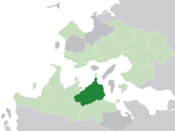
 Mëhidan (dark green) in the Kingdom of Trellin (light green) | |
| Nation | Trellin |
| Capital | Kalops |
| Area | |
| • Total | 125,624.96 km2 (48,504.07 sq mi) |
| Population (2013) | |
| • Total | 6,188,913 |
| • Density | 49/km2 (130/sq mi) |
| Demonym | Mehaidese |
| Area code(s) | 069, 070 |
Mëhidan (pronounced /meɪˈhiːdɛn/), officially the Fiefdom of Mëhidan (Trellinese: Tavesan Mëhaidoi), is a province of the Trellinese Empire. It is the twelfth-least populous province in Trellin and Hysera and the seventh largest by area.
Mëhidan borders Rezat to the west, Khatax to the south, Ternos to the southeast and fronts the Sea of Velar to the east and northwest. It has a population of 6,188,913 and covers a total area of roughly 125,600 square kilometres. The province's centre of government is at Kalops, which is also its largest city.
Geography and natural resources
The Mehaidese economy relies heavily on its natural resources. Gold is abundant in the north of the province, and the extraction and export of these deposits from their limestone beds has been the mainstay of the fiefdom's finances since its establishment. Timber is also a major product of Mëhidan.


