Union of Zorasani Irfanic Republics
This article is incomplete because it is pending further input from participants, or it is a work-in-progress by one author. Please comment on this article's talk page to share your input, comments and questions. Note: To contribute to this article, you may need to seek help from the author(s) of this page. |
Union of Zorasani Irfanic Republics
4 other official names
| |||||||||
|---|---|---|---|---|---|---|---|---|---|
 Emblem
| |||||||||
Anthem:
| |||||||||
 Zorasan in blue, Coius in light blue and claimed territories in dark blue | |||||||||
| Capital and largest city | Zahedan, UTC | ||||||||
| Official languages | Rahelian Pardarian | ||||||||
| Recognised regional languages | Kexri Syriati Yanogu | ||||||||
| Ethnic groups | See Ethnicity | ||||||||
| Religion | State religion: Irfan (Arta and Hasawi) Constitutionally recognised minority religions: Maronite Catholicism, Atuditism, Zoroastrianism, Druze | ||||||||
| Demonym(s) | Zorasani (common) Sattari (official) | ||||||||
| Government | Federal Sattarist single-party state | ||||||||
| Rahim Ali Haftar | |||||||||
| Gafur Qahhor | |||||||||
| Sadavir Hatami | |||||||||
| Adavazdar Golzadari | |||||||||
| Ibrahim Al-Fahim | |||||||||
| Legislature | Supreme Assembly of the Union | ||||||||
| Established | |||||||||
| 10 December 1979 | |||||||||
• Established | 1 January 1980 | ||||||||
• Turfan | February-July 2005 | ||||||||
| 13 July 2008 | |||||||||
| Area | |||||||||
• Total | 5,471,003 km2 (2,112,366 sq mi) | ||||||||
• Water (%) | 1.3% | ||||||||
| Population | |||||||||
• 2021 estimate | |||||||||
• 2012 census | 195,369,278 | ||||||||
• Density | 38.21/km2 (99.0/sq mi) | ||||||||
| GDP (PPP) | 2021 estimate | ||||||||
• Total | |||||||||
• Per capita | $13,802 | ||||||||
| GDP (nominal) | 2021 estimate | ||||||||
• Total | |||||||||
• Per capita | $10,035 | ||||||||
| Gini | 34 medium | ||||||||
| HDI | 0.784 high | ||||||||
| Currency | Toman (₮) | ||||||||
| Date format | dd.mm.yyyy | ||||||||
| Driving side | left | ||||||||
| Calling code | +39 | ||||||||


Zorasan, officially known as the Union of Zorasani Irfanic Republics is a Sattarist federal one-party state located in northern Coius. It is bordered by Tsabara and Behera to the north, Mabifia and Dezevau to the east, Shangea to the south, Ajahadya and Gulbistan to the west and is bound to the northwest by the Gulf of Parishar. Zorasan is the third largest country in the world with 4,692,920 km2 (1,811,950 sq mi) in land area, and with 206.28 million ihabitants as of 2021, it is the third most populous country in the world, though with a population density of 36.88/km2 (95.5/sq mi). Its capital and largest city is Zahedan, while other major urban areas include Borazjan (Pardarian UR), Faidah (Khazi UR), Sadah (Irvadi UR), Ad-Daydh (Ninevahi UR) and Izidhar al-Mina (Riyadhi UR).
Zorasan is the site of ancient civilisations, some the oldest in the world. The first recorded organised civilisation to emerge in the 5th century BCE was the Galdian civilisation, which inhabited the area now known as Ashkezar in northwestern Pardaran. The world's first written language in the form of Cuneiform emerged in modern-day Khazestan through the Ebtarian civilisation in 3,200 BCE. The Pardarian kingdoms would first be united in 2,100 BCE by the Sorsanid Empire which expanded to become one of the largest empires in early history and seized much of modern-day Zorasan. The empire would be succeeded by the Arasanid Empire in around 600 BCE, which would later see the emergence of a new monotheistic faith in the form of Irfan in the 320s BCE, and was ultimately overthrown in 300 BCE by the prophet Ashavazdar Fereydun, who established the First Heavenly Dominion, which expanded militarily to reconstitute the Sorsanid's territory and spreading the faith. In 50 BCE, the Second Heavenly Dominion succeeded the first and continued the Irfanic conquests across much of northern Coius and into parts of Bahia and Satria, itself forming one of the largest empires in history, under the Second Heavenly Dominion, the Irfanic world underwent a golden age of scientific and cultural discovery. The Third Heavenly Dominion succeeded the Second in 953 AD and would be marred by external invasions, decline and internecine violence before being overthrown by the Gorsanid dynasty, which reconstituted an imperial monarchy for the first time since the Arasanid Empire.
The Gorsanid Empire would rule over what would form modern-Zorasan for five centuries until it was defeated by various Togoti warlords in the 17th century, who established the Togoti Khaganate who would rule much of modern Zorasan until their own overthrow by the Khardarid Khaganate. During this time, the region underwent significant decline in culture, economic output and development, though this would be turned around in 1703 with the Gorsanid Restoration. However, the Togoti domination coupled with the Gorsanid inability to modernise fundamentally weakened the Empire in relation to its growing Euclean rivals, who began several colonial efforts to gain control over the empire's resources and key trade routes. Beginning the 1820s, the Etrurian conquest of Zorasan through several conflicts and forced unequal treaties eventually led to the empire's collapse and the partition of its territory by Etruria under the Treaty of Povelia, which established several colonial dominions, protectorates and treaty ports. Under Etrurian colonial rule, there would be several localised and regional uprisings and by late 19th century a resurgence in nationalism, though in often competing forms. In 1918, the Khordad Rebellion began and would last until 1922, though defeated the rebellion gave way to the Pardarian Revolutionary Resistance Command under the leadership of Mahrdad Ali Sattari, who authored Sattarism and was the most prominent advocate for the reunification of the former Gorsanid Empire. Zorasan would serve as a front in the Great and Solarian wars during the 1930s and 1940s, suffering extensive destruction. In the latter stages of the Solarian War, the Greater Solarian Republic was forced to conduct a full-scale withdrawal from Coius, abandoning its colonial possessions, within the power vacuum, several states would emerge out of the former colonies and protectorates - the Kexri Free Republic, Emirate of Irvadistan, Kingdom of Khazestan and the Emirates of Riyadha, while Pardaran was divided between the former protectorate Sublime State of Pardaran, the Pardaran Revolutionary Resistance Command, the Ashkezar Republic and numerous local warlords. In 1950, the Pardarian Revolutionary Resistance Command defeated its rival factions in the Pardarian Civil War, this was swiftly followed by the Khazi Revolution and in 1952, the two countries united to form the Union of Khazestan and Pardaran marking the beginning of Zorasani Unification. This three-decade long effort was marked by ideological tensions, terrorism and two major conflicts, the First and Second Rahelian wars, which pitted the UKP against first the Zubaydi Rahelian Federation, though the Federation was overthrown in a socialist revolution, establishing the United Rahelian People's Republic. In 1976, the UKP and URPR went to war and after thirteen months of conflict, the URPR was defeated and the UKP established the Provisional Revolutionary Government of Irvadistan and Riyadha, this was followed in 1979 by the Union Republic Referendum which would lead to a victorious vote for the establishment of the Union of Zorasani Irfanic Republics, which was officially founded in 1980.
The UZIR was established under a one-party system governed by the National Renovation Front and throughout the 1980s, was forced to focus primarily on repressing various revolts and uprisings against Zorasani unification within Irvadistan, as well as rebuilding a country that suffered near forty-years of conflict and instability. Through unification however, Zorasan quickly became the world's largest producer of oil and other hydrocarbons which enabled rapid reconstruction. In 1990, a reformist Front administration took power, heralding the Saffron Era in which the economy, governance and culture were liberalised. From 1990 to 2003, Zorasan recorded on average 10% GDP growth and over 90 million people were lifted out of poverty, while the population boomed from 111 million to 195 million by 2012. In 2000, the NRF government led by Ekrem Dalan began enacting broader and more reckless reforms that caused severe disruption to the economy and exacerbated the worsening crisis of inequality and social tensions. These issues erupted into civil unrest in 2005 and worsened by the manipulations of the Zorasani military who opposed the reform agenda. The Dalan-led government was removed from office in a constitutional coup and was replaced with the Interim Governing Authority which held power until 2008 during which time it re-wrote the national constitution. Many reforms were rollbacked and economic growth returned to high rates. In 2015, a new administration took power which continued steady reforms of the economy maintaining growth. In 2021, this administration was removed from office for corruption following a brief political crisis.
Today, Zorasan is considered a major power with significant economic, military, cultural and religious influence. Due to being the site of the world’s largest proven oil reserves and its high production, Zorasan is considered an energy superpower. Zorasan is a founding member of the Irfanic Cooperative Congress, the International Forum for Developing States, the Rongzhuo Strategic Protocol Organisation and a member of the Community of Nations, GIFA and the ITO.
Etymology
The roots of the name Zorasan can be traced back to the Middle Pasdani "Xwarāsān", meaning "Land of the Sun." It was first used to denote the expanse of territories under the Arasanid Empire, when in 325 BCE, Shah Farrokhan II proclaimed his empire to be the "greatest expanse under the Sun" in a series of poems written in that year. His coining of the term was adopted by the First Heavenly Dominion during the Rise of Irfan, when the Prophet Ashavazdar, declared his intention to "free all Zorasan from the bounds of ignorance." The term from its inception until the Pardarian Civil War in the late 1940s, was rarely used to denote a singular polity, but rather a geographical region, under the Arasanids it denoted the imperial heartlands, which corresponded mostly to the modern bounderies of Zorasan, while under the Heavenly Dominions, "Zorasan" was used to denote the entirety of the Irfanic World, often due to the metaphorical comparison of the Sun to Khoda. Its relationship with the rise and spread of Irfan, alongside the definable boundries of Zorasan provided by the Shahs enabled the term to become culturally and political engrained in both the Pardarian and Rahelian peoples.
The use of "Zorasan" as a geographical term continued under the post-Dominion Pasdani empires and would see continued use by Etruria following the Conquest of Zorasan. The dismemberment of Gorsanid Zorasan in 1860 by the Etrurian colonial authorities saw "Zorasan" fall out of official use as the Etrurians sought to identify their colonial posessions independently of one another to deter a unified uprising. Between 1860 and 1946, the Etrurian colonies in Zorasan were collectively referred to as the "Southern Dominions" (Vespasian: Domini Meridionali), while the various underground anti-colonial movements maintained the use of Zorasan illicitly.
Following the de-colonisation of Zorasan in 1946, in wake of the Solarian War, the term's use fell exclusively to political figures in Pardaran, as the Rahelian states emerging out of the Etrurian colonies strove to secure independent national identities. However, the term Zorasan remained highly popular among the rural and urban poor classes, who saw Zorasan as a moniker for a pre-colonial time of prosperity, unity and independence. The Pardarian Civil War and rise of Renovationism in wake of the Khazi Revolution resulted in Zorasan's useage returning to the norm and was subject to considerable propaganda, fuelled by Pan-Zorasanism and Zorasani unification. The completion of unification in 1980 saw "Zorasan" be adopted as the official name of the unified country.
History
Prehistoric
Classical antiquity
Rise of Irfan
Heavenly Dominions
Medieval
Early modern period
Khaganates
Gorsanid Restoration
Etrurian conquest
Modern
Colonial Zorasan
Zorasani unification
Since unification
Geography
Zorasan has a total area of 5,471,003 km2 (2,112,366 sq mi), making it the third largest country in world and the second largest in Coius after Shangea. Zorasan borders Tsabara, Behera to the north-north-east, Mabifia to east, as well as Devezau where the border is also demarcated by Lake Zindarud, one of the largest lakes in the world. To the south, it borders Shangea via the Kharkestar Corridor. To the west it borders Ajahadya and Gulbistan. To the direct north is the Gulf of Parishar, where Zorasan also possesses the Khazal Islands. Northwestern Zorasan has a coastline along the Acheolian Sea.
Zorasan consists of four distinct geographical areas, the Ashkezar Plain in the northwest, the Great Steppe, from which comes the Tinnin Plateau, the Hamun-e Faravani Plain and the foothills of the Hajjar Mountains, located along the country's northeastern borders with Mabifia and Behera. The most populous areas of Zorasan are the Ashkezar Plain and the Tinnin Plateau both of which are located in Pardaran. It is the rugged hills that emerge out of the Great Steppe that form the majority of Zorasan's mountainous regions in the form of the Tinnin Plataeu which contains Mount Fereydun, the highest point in the country at 5,615m (18,421 ft). The second highest point in Zorasan is Mount Kassoun, in Irvadistan and is located in the lower Hajjar Mountains, standing at 3,210m (10,531 ft). Much of Zorasan is dominated by vast tracts of open savanna plains, deciduous forests and shrublands. Northern Irvadistan transitions into arid and desert terrain, and is marked by the Almarana Depression which is 19,605 km2 (7,570 sq mi) is total area and on average 60m (200ft) below sea-level. The Great Steppe which constitutes most of southwestern Pardaran is a vast flat plain and rests at a higher altitude of 1,000m (3,280ft) above sea-level.
Zorasan's most prominent rivers include the Fiḍḍa River (2,394km) which is sourced from Lake Sattari and bisects Irvadistan from south to east-to-west before entering the Gulf of Parishar at Khadal. This is followed by the Abzâr River (2,102km) which is formed through the conjoining of the Qashanrud and Sabar rivers, both of which flow from the Great Steppe, the Abzâr deposits in the Acheolian Sea via Dahanesar.
Zorasan is also the site of three major lakes, Lake Zindarud which it shares a maritime border with Dezevau is one of the largest in the world, with a total area of 143,503km2 (55,406 sq mi), followed by Lake Jahandar at 20,070km2 (7,749 sq mi) and Lake Sattari at 7,902km2 (3,050 sq mi). However, Lake Jahandar is believed to have lost over 80% of its volume since 1980 owing to over-exploitation, poor water management and climate change.

Vast plains of the Great Steppe in western and southwestern Pardaran.

Mount Fereydun Zorasan's highest peak and part of the Tinnin Plateau.

Plains and hills of the Hamun-e Faravani.

Almanara Depression in northern Irvadistan.
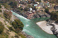
The Fidda River flowing through Sharorah, Latifardh
.jpg)


.jpg)

Climate
Biodiversity

Zorasan boast significant biodiversity both terrestrial and marine species, some of which are endemic solely to Zorasan present or historically. Terrestrial species present in Zorasan today include, foxes, gray wolves, bears, boars, wild pigs, jackals, lynxes and panthers. Non-predatory animals include water buffaloes, mountain goats and Satrian Elephants, who were introduced to the forested north-west in the late 15th century. Zorasan was historically home to the largest population of Coiatic Cheetahs, which went extinct in the late 1990s according to the World Institute for Wildlife Protection. Zorasan is also home to populations of Pasdani Leopards and Gilustani Tigers, however, both these species are considered endangered and under serious threat of extinction by the 2030s. Avian species native to Zorasan include falcons, pheastants, eagles and Sparrowhawks.

The marine wildlife of Zorasan differs greatly, with the Gulf of Parishar being home to a wide variety of large mammals such as minke whales, humpback whales, bottle-nose dolphins and along the Harat Delta region, populations of dugongs have been recorded. The establishment of several Marine Life Protected Areas has enabled the return of a permanent population of hunchback dolphins. To the south, Lake Bakhtegan is home to a wide variety of freshwater fish, including large species of sturgeon. The presence of sturgeon stocks has resulted in Lake Bakhtegan being a major source for beluga caviar.
The situation regarding wildlife in Zorasan is ranked as one of the most serious to numerous NGOs and international charity groups. Over 80 species are on red lists for possible extinction. According to the WIWP, Zorasan has lost over 56% of its native wildlife since the early 20th century. Efforts by Zorasani state governments to regulate the protections of wildlife are regularly overridden by federal legislation that fast tracks the exploitation of mines and other subterranean resources without the input of Zorasan’s National Wildlife Institution or the Union Ministry for Environmental Protections. As of 2020, the final regulations demanding studies of local wildlife to assess the impact of human development was scrapped.