Zha'tar: Difference between revisions
m (1 revision imported) |
mNo edit summary |
||
| (2 intermediate revisions by the same user not shown) | |||
| Line 17: | Line 17: | ||
| map_alt = | | map_alt = | ||
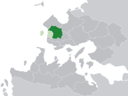
| map_caption = Location of '''Zha'tar''' (dark green) in [[Hysera]] (light green) and [[Trellin]] (dark grey) | | map_caption = Location of '''Zha'tar''' (dark green) in [[Hysera]] (light green) and [[Trellin]] (dark grey) | ||
| subdivision_type = [[:Category:Nations of the Trellinese Empire|Nation]] | | subdivision_type = [[:Category:Nations of the Trellinese Empire|Nation]] | ||
| subdivision_name = [[Hysera]] | | subdivision_name = [[Hysera]] | ||
| Line 59: | Line 48: | ||
| area_blank2_title = | | area_blank2_title = | ||
<!-- square kilometers --> | <!-- square kilometers --> | ||
| area_total_km2 = | | area_total_km2 = 63106 | ||
| area_land_km2 = | | area_land_km2 = | ||
| area_water_km2 = | | area_water_km2 = | ||
| Line 67: | Line 56: | ||
| area_blank1_km2 = | | area_blank1_km2 = | ||
| area_blank2_km2 = | | area_blank2_km2 = | ||
| elevation_footnotes = | | elevation_footnotes = | ||
| elevation_m = | | elevation_m = | ||
| Line 89: | Line 66: | ||
| timezone1 = | | timezone1 = | ||
| utc_offset1 = | | utc_offset1 = | ||
| postal_code_type = | | postal_code_type = | ||
| postal_code = | | postal_code = | ||
| area_code_type = | | area_code_type = [[Telephone numbers in Trellin|Area code(s)]] | ||
| area_code = | | area_code = 019, 020 | ||
| iso_code = | | iso_code = | ||
}} | }} | ||
'''Zha'tar''' (pronounced {{wp|Help:IPA_for_English|/ʒæˈtɑr/}}), officially the '''Dominion of Zha'tar''' ([[Ahéri language|Ahéri]]: ''Qúnini ti'Zha'tar'') is a province of the [[Hysera]]n and [[Trellin|Trellinese empire]]s. It is the fifteenth smallest province by total area and the eleventh-most populous province. | '''Zha'tar''' (pronounced {{wp|Help:IPA_for_English|/ʒæˈtɑr/}}), officially the '''Dominion of Zha'tar''' ([[Ahéri language|Ahéri]]: ''Qúnini ti'Zha'tar''), is a province of the [[Hysera]]n and [[Trellin|Trellinese empire]]s. It is the fifteenth smallest province by total area and the eleventh-most populous province. Within Hysera alone, it is the largest province by area. The province borders [[Emla]] to the north, [[Arimathea]] to the northeast, [[Saheri]] to the south and [[Hysera (province)|Hysera]] and the [[Sea of Jajich]] to the west. It has a total area of roughly {{convert|63106|sqkm|sqmi|abbr=on}} and a population of 9,269,235. | ||
Only a small portion of Zha'tar is coastal, a narrow and densely-populated strip between [[Aloyu]] and [[Pycara]] that is about {{convert|26|km|mi|abbr=on}} from north to south. Away from the wet and rainy coast, Zha'tar is characterised by arid and semi-arid climates, with highland and desert extending across the centre and northwest of the province. The [[Vekra Retiqa]], one of [[Teudallum]]'s most significant {{wp|cordillera}}s, traverses the province from the northwest to the east. The highest point in Hysera and indeed the Trellinese Empire is [[Torúmalana]], a mountain of {{convert|5711|m|ft|abbr=on}}, in southeastern Zha'tar. The eastern portion of the province is dominated by the [[Ludef Plateau]], one of the highest plateaux in Astyria, with average elevations about {{convert|3300-3500|m|ft}}, more than two miles above sea level. The provincial capital, and seat of its lordship, is at [[Ludef]], an ancient city established on the plateau, which is home to over 1.4 million people and one of Astyria's highest major cities. | |||
{{Navbox Subdivisions of the Trellinese Empire}} | {{Navbox Subdivisions of the Trellinese Empire}} | ||
[[Category:Provinces of Trellin]][[Category:Trellin]][[Category:Astyria]] | [[Category:Provinces of Trellin]][[Category:Trellin]][[Category:Astyria]] | ||
Latest revision as of 19:15, 8 March 2024
Zha'tar | |
|---|---|
 | |
| Nation | Hysera |
| Capital | Ludef |
| Area | |
| • Total | 63,106 km2 (24,365 sq mi) |
| Population (2013) | |
| • Total | 9,269,235 |
| • Density | 146.88/km2 (380.4/sq mi) |
| Demonym | Zhaatarti |
| Area code(s) | 019, 020 |
Zha'tar (pronounced /ʒæˈtɑr/), officially the Dominion of Zha'tar (Ahéri: Qúnini ti'Zha'tar), is a province of the Hyseran and Trellinese empires. It is the fifteenth smallest province by total area and the eleventh-most populous province. Within Hysera alone, it is the largest province by area. The province borders Emla to the north, Arimathea to the northeast, Saheri to the south and Hysera and the Sea of Jajich to the west. It has a total area of roughly 63,106 km2 (24,365 sq mi) and a population of 9,269,235.
Only a small portion of Zha'tar is coastal, a narrow and densely-populated strip between Aloyu and Pycara that is about 26 km (16 mi) from north to south. Away from the wet and rainy coast, Zha'tar is characterised by arid and semi-arid climates, with highland and desert extending across the centre and northwest of the province. The Vekra Retiqa, one of Teudallum's most significant cordilleras, traverses the province from the northwest to the east. The highest point in Hysera and indeed the Trellinese Empire is Torúmalana, a mountain of 5,711 m (18,737 ft), in southeastern Zha'tar. The eastern portion of the province is dominated by the Ludef Plateau, one of the highest plateaux in Astyria, with average elevations about 3,300–3,500 metres (10,800–11,500 ft), more than two miles above sea level. The provincial capital, and seat of its lordship, is at Ludef, an ancient city established on the plateau, which is home to over 1.4 million people and one of Astyria's highest major cities.

