Mniohuta: Difference between revisions
No edit summary |
No edit summary |
||
| Line 94: | Line 94: | ||
|Gini_rank = | |Gini_rank = | ||
|Gini_year = 2015 | |Gini_year = 2015 | ||
|Gini_change = | |Gini_change = increase | ||
|Gini_category = | |Gini_category = | ||
|HDI = 0.82435 | |HDI = 0.82435 | ||
Revision as of 13:16, 10 February 2022
Confederation of Mniohuta ᐅᔭᑌ ᒼᓂᐅᐦuᑕ 1 official name
| |||
|---|---|---|---|
| Motto: «ᐁᓬ ᖧᐊuᑲ ᓬᔪᑎᔦᑭᔭ, ᐅᐘuzᐁᐃᓬᐊ᙮» "In great endeavour, union." | |||
| Anthem: ᐅᐩáᑌ ᐅᓬóᐘᐣ Oyáte Olówaŋ "Song of the Nation" | |||
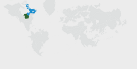
 Location of Mniohuta on Earth. Claimed territory in light green. | |||
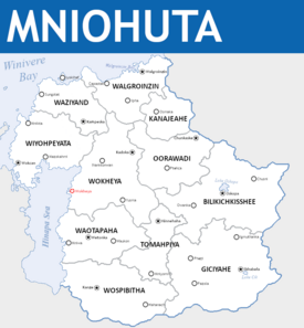
 Political Map of Mniohuta | |||
| Capital | Wokheya | ||
| Largest city | Walgroinzin | ||
| Official languages | Mniyapi | ||
| Recognised regional languages | |||
| Ethnic groups (2020) | [a] | ||
| Religion | List of religions
| ||
| Demonym(s) | Mniohutan Mnohati (plural) | ||
| Government | Parliamentary federated constitutional monarchy | ||
• Premier | Chaska Chimaka | ||
• Chief of the Council | Odakota Akecheta | ||
| Legislature | Conclave of the Confederacy | ||
| Council of Elders | |||
| Council of the People | |||
| Independence from Tyrrslynd | |||
• Event | 3/14/ | ||
| Area | |||
• Total area | 897,115 km2 (346,378 sq mi) | ||
• Water (%) | 5 | ||
| Population | |||
• 2020 census | 26,431,592 | ||
• Density | 30.19/km2 (78.2/sq mi) | ||
| GDP (nominal) | 2020 estimate | ||
• Total | $457,073,760,600 | ||
• Per capita | $15758 | ||
| Gini (2015) | low | ||
| HDI (2015) | very high | ||
| Currency | Mniohutan mazaska (₼) | ||
| Time zone | UTC -5 | ||
| Date format | dd/mm/yyyy | ||
| Driving side | right | ||
| Calling code | +68 | ||
| Internet TLD | .mt | ||
Mniohuta (/mniːoʊhʊtjæ/ muh-nee-O-hu-ta), officially the Confederacy of Mniohuta, is a country in northeastern Norumbia. Its consulates cover a landmass of around 897,115 square kilometers (346,378 square miles), bordered by Elatia to the Northwest, Lake Thanka to the West, Winivere Bay to the North, Awasin and Moxaney to the Northeast, the Chenes to the West, and Gristol-Serkonos to the South. The majority of the 34,000,000 citizens of Mniohuta live in major cities such as Walgroinzin or in the central plain along the many rivers descending towards Lake Thanka from the North and Osawanon mountain ranges. Wokheya is the capital of the country while Walgroinzin is the largest and most populous city in the country. Description of the people.
Various indigenous peoples have inhabited what is now the TL;DR
Etymology
The origins of the name
Demonyms
A
Official title
B
Geography
A
Climate
ABC
History
Evidence of human habitation in what is now Mniohuta dates back to at least DATE BCE. Archaeological records suggest that
Descriptor
Formation of permanent settlements
Asherionic Wars
Unification of the eight tribes
Democratization and Industrialization
Contemporary History
Government and politics
Premier
Chief of the Council
Mniohuta is a federal, libertarian socialist council republic in the communalist tradition. TEXT TEXT TEXT TEXT.
The Chief of the Council of the House of... premier .
Law
Legal system.
Mniohuta and also description.
Foreign relations
Since the Title and resulting political ...
Military
When the
Constituencies
Description of civil organization and of prefectures(?).
| Commonwealth | Capital | Population | |
|---|---|---|---|
| File:Flag of Walzenia modern.png Mniohuta - Confederacy of Mniohuta | Capital | Population | |
| File:Flag asd.svg Name - Name title | Zorai | 6,201,418 |
Economy
what the.
Agriculture
Energy
Tourism
Transporation
Science and technology
Demographics
With a population of X then Y Template:Largest cities in Mniohuta
Ethnic groups
DESCRIPTION THATS REALLY AWESOME:
- NAME 1: YEAH BABY.
- NAME 2: WHEN WHEN YOU.
Additionally, there are countless immigrant communities which do not fit into any of these groups.
Languages
awesome text.
Religion
Mniohuta time baby..
Education
H.
Health
H.
Culture
1
Architecture
Mnio ysdgjesngewojgweewg.
- Swaglord21 002.jpg
Yeah.
- Wowthatscrazy.jpg
Description.
Cinema
Maybe
Clothing
Swag.
Cuisine
time to talk to hiero.
Holidays
swag day.
Literature
edgar allen ur mom.
Sports
woooo sports ball baby.
- ↑ Since the unification of the eight tribes most of the more minor tribes were absorbed by the larger ethnic groups such as the Thituwan, Hetuwa, Mniwa, or were already fairly closely related.


