Kajera: Difference between revisions
Jump to navigation
Jump to search
(fixing the template) |
mNo edit summary |
||
| Line 131: | Line 131: | ||
}} | }} | ||
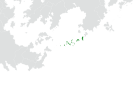
'''Kajera''' (insert pronunciation guide later IPAC), officially the '''Republic of Kajera''', is a country in eastern [[Ajax#Malaio|Malaio]]. Its population of 32,010,871 people is spread out across [[Kajera#Geography| | '''Kajera''' (insert pronunciation guide later IPAC), officially the '''Republic of Kajera''', is a country in eastern [[Ajax#Malaio|Malaio]]. Its population of 32,010,871 people is spread out across 14 islands and [[Kajera#Geography|21 coral atolls]], comprising 1,131 individual islands and islets. It shares {{wp|maritime boundaries}} with [[Daobac]] to the north, [[Pulau Keramat]] to the northwest, and [[Onekawa-Nukanoa]] to the southwest. Kajera's capital and largest city is Rimae, situated on the eponymous island. It has one of the largest portions of {{wp|Territorial waters|territory composed of water}} of any sovereign state in the world. Approximately 40% of the population are defined as being 'urban,' with a significant population (26%) of [[Kajera#Demographics|semi-nomadic seafaring groups]]. | ||
Revision as of 02:17, 13 November 2022
Republic of Kajera | |
|---|---|
|
Flag | |
| Motto: "Tual, tumane, tuemeaole." "For sun, for sea, for memory of all." | |
| Anthem: Buledoldanna "Bluewater Ode" | |
 Location of Kajera on Earth. | |
| Capital | Rimae |
| Official languages | none at the federal level |
| Recognised national languages | |
| Demonym(s) | Kajeran |
| Government | Unitary parliamentary republic |
• President | Sabana Lokilone |
• Speaker | Hale Maron Nejinikor |
| Legislature | Konkomman |
| Population | |
• 2019 census | 32,010,871 |
| GDP (nominal) | 2019 estimate |
• Total | $784,266,339,500 |
• Per capita | $24,500 |
| Gini (2019) | 20.3 low |
| HDI (2019) | very high |
| Currency | Kajeran tala |
| Time zone | UTC |
| Date format | dd/mm/yyyy |
| Driving side | right |
| Calling code | +82 |
| Internet TLD | .ka |
Kajera (insert pronunciation guide later IPAC), officially the Republic of Kajera, is a country in eastern Malaio. Its population of 32,010,871 people is spread out across 14 islands and 21 coral atolls, comprising 1,131 individual islands and islets. It shares maritime boundaries with Daobac to the north, Pulau Keramat to the northwest, and Onekawa-Nukanoa to the southwest. Kajera's capital and largest city is Rimae, situated on the eponymous island. It has one of the largest portions of territory composed of water of any sovereign state in the world. Approximately 40% of the population are defined as being 'urban,' with a significant population (26%) of semi-nomadic seafaring groups.

