Emla
This article is incomplete because it is pending further input from participants, or it is a work-in-progress by one author. Please comment on this article's talk page to share your input, comments and questions. Note: To contribute to this article, you may need to seek help from the author(s) of this page. |
Emla | |
|---|---|
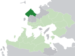
 Location of Emla (dark green) in the Kingdom of Trellin (light green | |
| Nation | Trellin |
| Capital | Bara ti'Emla |
| Government | |
| • Duke | Andrakus Evdar |
| Area | |
| • Total | 71,143.82 km2 (27,468.78 sq mi) |
| Population (2013) | |
| • Total | 17,014,937 |
| • Density | 240/km2 (620/sq mi) |
| Demonym | Emlan |
| Area code(s) | 022, 023, 024 |
Emla (pronounced /ˈɛmlɑː/), officially the Stonehewn Duchy of Emla (Ahéri: Aihei Izker ti'Emla; Trellinese: Berend Sialechu Emlika), is a province of Trellin, located in the northwest of the country. Its administrative and political centre is Bara ti'Emla, which is also its largest city. It is bordered to the south by Zha'tar, to the east by Arimathea and on all other sides by the Sea of Jajich.
Emla is the twelfth largest province in Trellin, at 71,143.82 square kilometres (27,468.78 sq mi), and with 17,014,937 people as of 2013 it is the third-most populous in the empire. Its geography is predominantly mountainous, with extensive ranges in the centre and southeast of the province. The steep granite cliffs on the northwest coast have become Emla's icon, appearing on its flag as a white wall. Halfway along their unbroken stretch from the western to the northern extremes of the province, the Lasara river, just over 182 kilometres (113 mi) long, plunges 150 metres (490 ft) into the Sea of Jajich below, and it is at this waterfall that the province's capital is built. The west of the province is defined by relatively flat land on the high coastal plateau, rising slowly towards the foothills of Emla's mountain ranges.
The province's economy is one of the more industrialised in Trellin, focused on its centres of IT and pharmaceutical production at Bara ti'Emla and other cities.
History
Early history
The first settlements in Emla were on its southwest coast, on the fertile plains of Ímorth, where a number of small cities prospered. These were mostly subjugated by the emergent kingdom of Ledh ti'Gara in the early first millennium BC. When Ledh ti'Gara was annexed by the expanding Hyseran Empire, its northern towns quickly followed as Hyseran armies and settlers moved along the coast. The city of Bara ti'Emla was established as Hysera's then-northernmost fortress in 472 BC to watch over the Lasara river.
Middle Ages
In 811, during the siege of Hyser, Emla seceded from the empire to form the independent Duchy of Emla.
It later joined the Trellinese Empire in 1532, three years after the marriage of its Duchess Moruza to King Tor'qim of Trellin.
Geography
Emla's dramatic sea-cliffs are the result of seismic activity c. 300,000 YBP that created a substantial fault block, maybe about 140 kilometres (87 mi) in length. The Emlan coastline probably dates to this time. The Lasara's course was shifted abruptly from its former course and now flows over cliffs composed of hard, white granite.


