Arthasthan
This article is incomplete because it is pending further input from participants, or it is a work-in-progress by one author. Please comment on this article's talk page to share your input, comments and questions. Note: To contribute to this article, you may need to seek help from the author(s) of this page. |
Birlikist Republic of Chanda 𑐀𑐬𑐎𑐶𑐣𑐵𑐡𑐾𑐔 𑐧𑐶𑐬𑐮𑐶𑐎 𑐀𑐫𑐩𑐵𑐑𑐲𑐵𑐑𑐵 𑐄𑐮𑐸𑐲 Arkinadesh Birlik Aymagsaga Ulus (Chandan) | |
|---|---|
 Flag
 Emblem
| |
 Location of Chanda in Coius | |
| Capital and largest city | Taglikend |
| Official languages | |
| National language | Chandan |
| Ethnic groups | See Ethnicity: Bashtugin: 48.9% Satrian: 30.1% Xiao: 18.3% Other: 2.5% |
| Religion | Badi: 53.9% Zohism: 18.8% Tulyata: 11.1% Ashram: 9.1% Other/Irreligious: 5.8% |
| Demonym(s) | Chandan |
| Government | Unitary presidential Birlikist republic |
• Premier | Erkin Sabir |
• President | Pernille Urksal |
| Legislature | National Assembly |
| Independence from Xiaodong | |
| 1934 | |
| 1936 | |
| 1949 | |
| 1951 | |
| Area | |
• Total | 681,891.84 km2 (263,279.91 sq mi) |
• Water (%) | 0.380 |
| Population | |
• 2020 estimate | 28,424,000 |
• Density | 168/km2 (435.1/sq mi) |
| GDP (PPP) | 2016 estimate |
• Total | $ 454.64 billion |
• Per capita | $ 15,995 |
| GDP (nominal) | 2015 estimate |
• Total | $179.49 billion |
• Per capita | $6,315 |
| Gini (2016) | 40.237 medium |
| HDI (2016) | 0.710 high |
| Currency | Soʻm (ADO) |
| Date format | yyy-mm-dd |
| Driving side | right |
| Internet TLD | .ad |
Chanda (Chandan: 𑐀𑐬𑐎𑐶𑐣𑐵𑐡𑐾𑐔, Arkinadesh), officially the Birlikist Republic of Chanda (Chandan: 𑐀𑐬𑐎𑐶𑐣𑐵𑐡𑐾𑐔 𑐧𑐶𑐬𑐮𑐶𑐎 𑐀𑐫𑐩𑐵𑐑𑐲𑐵𑐑𑐵 𑐄𑐮𑐸𑐲, Arkinadesh Birlik Aymagsaga Ulus), is a landlocked country in Coius with a population of 28 million people. On the southeastern edge of Satria, it borders Xiaodong to the south and east, Baekjeong to the west, and Ajahadya to the north.
The region comprising modern-day Chanda was first inhabited by various Satrian tribes who formed various petty kingdoms in the region. The region historically has been influenced by the Xiaodongese dynasties from the south and Ajahadyan dynasties from the north. Xiaodongese influence would start in the 5th century BCE, when the Xiang dynasty conquered and forced the local Aholisi leaders in the south to submit to the Emperor, although they were allowed significant amount of autonomy. After the collapse of the Xiang dynasty, Xiaodongese domination wouldn’t return until the Tao Dynasty in the 8th century, which was more assertive than previous tributary system. The local tribes in the north remained independent until Ajahadya unified and brought the region under their influence starting in the 6th century CE. The region would be firmly under their control under various dynasties until the 16th century.
In the 16th century, the Togoti Khaganate invaded the region of Chanda as a part of their conquests. Due to the threat of Xiaodong, Togoti officials would settle the region with friendly tribes in order to supply troops, leading to a large Togoti community in the region. Despite the threat of conflict, the region became wealthy and saw a growing population of Togotis settlers. After the collapse of the Khaganate, a major general named Akdoğan, established his own fiefdom which became the Akdoğan Khanate. The Khanate was multi-ethnic society and the Togoti and the Aholisi cultures started to blend in the cities to form the Akdoğan culture, the predecessor to the modern Chandan culture. However in the mid 19th century, the Heavenly Xiaodongese Empire gradually subverted the Khanate's government and eventually annexed the country in 1885. For 50 years Chanda existed as protectorate under nominal direct control of the Xiaodongese emperor. By the 20th century the ideals of nationalism arrived stirring unrest started to grow.
These tensions grew until it exploded during the Great War, which saw Xiaodong at war with major world powers. Throughout the 1930s the People's Liberation Army fought Xiaodong in the Chandan War of Independence, until its surrender in 1935 allowed them to overthrow the protectorate government. While a Provisional Government would be granted formal independence with the Treaty of Keisi, in reality the region was governed by the West Shalegho Commandery, a Pardal Republic controlled by the People's Liberation Army. A combination of ethnic tension, dispute over national allegiances, and ideological disagreements led to infighting and power struggles in the People's Liberation Army. In the end the Five Leaders of Chanda led by Nurlan Sabir, were able to win in a struggle for power known as the National Revolution. In order to end their status as an international pariah, the Republican Revolution led to the end the Commandery and establishment of a Republic based upon the principles of Birlikism in 1951.
Chanda implements a variant of socialism based upon Birlikist thought, which led to the People's Liberation Army being a significant role in the country’s economic system. Originally it maintained total control over economic policy, but has has since shifted away after embracing some market reforms during 1980s. Today the Chandan economy functions under what is called neo-Birlikist economics, a form of distributism where the military works with the workers of cooperatives to implement economic policy after receiving directions from the government. Nevertheless, the PLA has a significant presence in Chandan society as part of the Internal State. While the government's pro-market policies have initially resulted in significant economic growth, corruption in the Corporations has hampered effective growth. As a result, government officials are increasingly relying on the People's Liberation Army to implement economic policy again.
The Republic was founded upon the ideological principles of Birlikism, establishing a unitary state governed by a powerful central government to enforce national unity. Chandan politics is characterized by the Internal State, where numerous power struggles between various political factions, which has led to the country being labled a Southern democracy. The country considered a middle power in Kylaris despite its population and geographic location, due to geopolitics of Coius. Due to its historical animosity with Xiaodong, it is closely allied with Senria and is a member of BCO, SAMSO, and COMDEV. Despite being a member of SAMSO, it maintains a large military for its population. It is also a member nation of the Community of Nations and the International Trade Organization.
Etymology
The name "Chanda" is an Etrurian exonym originally derived as Chandaman, from an ancient Xiaodongese term, “Across the mountain” (山对面, "Shān duìmiàn"), named for the general regions north of Shalegho mountain range. In the 19th century, Etrurian explorers used Chandaman to name the Chandan Plateau, before it was shortened to just Chanda. From then on, it would be used as a geographical term to refer to the region on Euclean colonial maps. In 1935 the defeated Heavenly Xiaodongese Empire was dismantled by the Treaty of Keisi which granted independence to a new country named Chanda. Even though the Chandan Republic never controlled any of its claimed territory, the name remained even after the formation of the current Republic of Chanda.
The native endonym Arkinadesh, is a shortened compound of several words which originate from different languages. The word first originated from dákṣiṇadesh; a combination of the Parbhan word dákṣiṇa meaning south and -desh, an affix meaning land. Thus it literally means "southland" which was used as a term for the general region south of Satria. When the Togoti Khaganate invaded in the 16th century, its officials added the word Ardyn, meaning people or tribe, to refer to the inhabitants of the region. Thus the phrase Ardyn Daksinadesh, literally "people of the southern land", was used to refer to the people of the region by the Togoti Khaganate and then its regional successor the Akdoğan Khanate. However over the course of centuries, the phrase merged to form a shortened compound word and the meaning of the word shifted to mean "southern people land" or "land of the southern people". By the late 19th century, the modern definition of the word was widely accepted in the local population as they considered themselves as the southernmost people in Satria.
The phrase "Aymagsaga Ulus", the Chandan phrase for republic, means "state ruled by the people's assembly". Thus the full name of the country, “Arkinadesh Birlik Aymagsaga Ulus”, would mean something akin to “Land of the Southern People governed by a United State ruled by a people's assembly”.
History
Prehistory
The region that is now Chanda has been inhabited before the Neolithic period, with evidence going back 30,000 years ago. Pastoralism developed during the Neolithic, as the region's climate and terrain are best suited for a nomadic lifestyle.The Neolithic Era also saw the arrival of the Sataro-Euclean people around 10,000 BCE, the ancient ancestors of the Aholisi people. Much like the other peoples of Steppe, the proto-Aholisi would have been largely nomadic and would have seen considerable migration around the region. By 1000 BCE, the proto-Aholisi people adopted a semi-nomadic lifestyle in the southeast region of the Great Steppe. While they didn't completely abandon a migratory lifestyle, they largely remained in one region. Their settlement resulted in the organizations into small tribal kingdoms.
Antiquity (~1300 BCE to 1 CE)
Before the 1st century CE, Xiaodong under the Xiang dynasties exerted some control over the southern Tepaliklar highlands and the tribes that inhabited it, in the form of autonomous tributary states. The extent of Xiaodongese influence depended on the stability of the dynasty, with declining power resulting in a decline of influence in the region. The collapse of the Sun dynasty resulted in the Xiaodongese presence completely recedeing for several centuries and local tribes reasserted their independence. These tribes took advantage of the weakened powers to the south and conducted raids against the Xiaodongese states. In general however, they largely raided each other and remained fragmented.
Pre-Togoti period (1 CE-1560 CE)
- Rise of the Tao Dynasty
- Tributary states is eventually established by 900s
- Xiaodong establishes piecemeal creation of institutions of state
- Partial conversion to Zohism
- The Chandan tribes breaks free when the Tao Empire declines
- Largely keeps the institutions founded
- Establishes the Confederation of Kings
- Rise of the Jiao dynasty (1300-1600)
- Tributaries reestablished in the south
- More institution building
- Jiao rules starts to decay
Togoti Era (1560-1665)
- Conquest by the Togoti Khaganate
- Chanda becomes intergrated with the empire
- Introduction of technology and culture
- Introduction of Badism
- Settlement of Togoti troops in Chanda
- Togoti herdsmen migrate to Chanda
- The western plateau & cities are settled
- Akdoğan takes control during the civil war
Akdoğan Era (1665-1888)
- Foundation of the Akdoğan Khanate
- Akdoğan intergrates diverse ruling elites
- Establishes effective governance
- Standardized economic practices
- Rise of a syncretic culture, the Akdoğans
- Largely occurs in the western Plateau
- Formal tributary status by 1770s; little actual control
- Chandans recognise the rule of the Emperor in 1861
- Xiaodong garrisons troops in 1871
- Xiaodong appoints the next Khan in 1879
- Treaty signed allow Emperor to appoint important officials in 1885
Imperial Xiaodong Era (1885-1934)
- Khanate annexed by Xiaodong
- Chanda is incorporated into the empire
- Attempt by Xiaodong to assimilate
- Rise of Chandan nationalism
- Great War and independence war
- Independence granted in 1935
Pardal Republic (1934-1951)
- Formation of the West Shalegho Commandery
- In fighting
- The National Revolution
- War with separatist forces
Republic of Chanda (1951-present)
- Sabir declares the Republic in 1951
- Birlikism becomes the national ideology
- Socialist economics, cultural revolution
- War with the XNLO (1947-1995)
- Revolutionary institutions keeps things in line
- Chandan-Ajahadyan wars
- Alignment with Senria and COMSED membership.
- Abandon socialist economics
- Partial democratization & liberalization
Geography

Chanda's geography is dominated by the western Shalegho mountain ranges in the southeast and the east, with elevated highlands covering the majority of the country. To the northwest, the foothills of the Shalegho mountains mark the border between Ajahadya and Chanda. To the southeast, the mountains generally divide Chanda from Xiaodong, although several large valleys cut through it. In between, is the large Chandan Plateau, after which the country's exonym is derived.
The country can be divided into four distinct geographical regions, the lowlands, the Chandan Plateau, the Chandan Highlands, and the Southern Slopes. The Lowlands consist of hilly terrain lying less than a kilometer above sea level. Despite the lower elevations less than a quarter of Chandans live in this region. The Lowlands and the Plateau are separated by the Chandan Ridge, a relatively steep mountain face. Despite its name, the Plateau is not flat, with its average elevation between 1 kilometers and 2 kilometers above sea level. The plateau itself is a steppe with rolling hills and small lakes interspersed with mountain ranges that generally run parallel to the Shalegho and Biafo ranges. The Plateau makes up the majority of the country and is where most of Chanda's population lives.
The Highlands consist of the two main mountain ranges in the country; the Shalegho Mountains in the east and the smaller Biafo Mountains to the west. It contains the country's highest point, at 5,621 meters above seal level. The mountain divide traditionally marks the boundary between South Coius and Satria. The mountains also mark the southern boundary of the Bashurat River Basin; the headwaters of the Dakia, Kaa, and Skai river originate in the highlands. Due to the high altitude few Chandans live in this region. Dividing the Shalegho and Biafo mountains is a wide valley known as the Gurkhan Pass, at only 1633 meters above sea level. Geographically considered part of South Coius, the region of South Chanda is isolated from the rest of Chanda by the mountain ranges. Unlike the Plateau, the region has a relatively steep mountain slope and largely consists of ridges and valleys leading away from the mountains. Around one-third of Chandans live in this region, largely from the Tog Aholisi minority.
Climate

Chanda's climate is largely determined by elevation. In the Lowlands, with the border with Ajahadya, the climate is a hot semi-arid climate. In the Plateau, which covers a majority of the country, it is a cool semi-arid climate. In the Highlands there are a Solarian climates and various humid continental climates. In the mountain peaks, there is a icy mountain climate, with snow almost year round. In the South Region on the mountain slopes, there is a more mild oceanic and humid subtropical climates. However eventually gives way to more cool semi-arid climates.
The majority of precipitation arrives between from December to June as the remnants of storms from Ajahadya. Most of the precipitation from these storms falls in the mountains as snow. Temperatures across most of Chanda swing wildly throughout the year, with cold temperatures in winter due to its elevation, and hot summers. The only exceptions are in the mountain areas and high mountain valleys where it remains consistently cold or the southern slopes of the mountains at lower elevation which experiences more moderate temperatures.
Biodiversity


Despite its largely dry climate, Chanda is home to diverse floral and fauna, espeically within the mountainous regions. There are ten nature reserves and nine national parks in Chanda that provide safe haven for many rare and endangered plants and animals. Chanda is commonly divided into into the Plateau biome and the Mountain biome, although each biome can be easily divided into a number of different biotic zones.
The Plateau biome is characterised by a semi-arid steppe that is generally considered to cover the Plateau itself and the Lowlands. Grassland and shrubland covers a majority of the biome as well as some desert vegetation, although some hardy trees make up sparse forests. The grassland steppe is a defining characteristic of the biome and the country's ecosystem as a whole. Due to the dry conditions the region, wildlife is most commonly found around the rivers that flow from the mountains into the Bashurat River Basin in the north. Common wildlife in this area include foxes, gazelle, deer,and the manoel cat.
The Mountain biome is characterised by colder and wetter weather with most of the precipitation falling as snow. As a result, the region forms the southern watershed for the Bashurat River Basin. Furthermore the rain shadow of the Shalegho causes the southern slope of the mountain to be warmer and drier. The biome is covered by forests at the lower elevations before the trees eventually give way to an subalpine zone. Above the tree line, is an alpine tundra devoid of large vegitation because of its elevation. Common wildlife in the region are suited to the mountainous terrain, which include the Snow Leopard, the Coian Lynx, and Argali.
Government and politics


Chanda's political system is outlined by a constitution known as the Declaration of the Birlikist Republic written in 1951. Under the Declaration, the country is a unitary presidential republic organized along the ideals of the Birlikist ideology. Chandan politics largely revolve around the power struggles between the factions over control of the country's institutions. Furthermore there are numerous clandestine organisations that exert significant control over Chanda, which is known as the Internal State. The National Assembly is the the country's sole law making body. The President is supreme commander of the armed forces, including the PLA, and also has powers over the implementation of policy. As one of its functions, Supreme Council of the Republic is the constitutional court of the country, where it determines the constitutionality of policy. The economic power the People's Liberation Army wields over the economy has been described as "hegemonic" by academics. Chanda is widely considered as an undemocratic hybrid regime by international observers and an extreme example of a Southern democracy.
Supreme Council of the Republic
The Supreme Council of the Republic is the highest institution in the executive branch, which is led by the Premier. The Council serves as a collective head of state, constitutional court, and de facto upper house for the National Assembly.
Under the principles laid out in the Declaration, the Council serves as the constitutional guardian of the Republic, tasked with ensuring that actions by the Assembly or the Districts do not violate the constitution. Thus as part of its mandate, it has the power of judicial review and the ability to strike down any laws or actions that it believes that violates the principles of the Declaration with a majority vote. The Council may issue rulings whenever it sees fit on any institution of the republic, including ones made by regional government. In addition it wields some legislative powers, with the authority to veto legislation from the National Assembly. Finally, the Supreme Council is the only institution with direct oversight over the People's Liberation Army, and serves to direct its operations on behalf of the President.
President
While the President is technically a member of the Supreme Council, the President serves as head of government and commander in chief of the Armed Forces. The President is elected by an corporatist electoral college for a four year term. While the President may be impeached and removed for misconduct by a majority vote, they cannot be dismissed from office through a vote of no confidence.
They are responsible for the implementation of the constitution, and for the exercise of executive powers in implementing the decrees and general policies approved by the Supreme Council. The President is assisted by a council of ministers, known as the Executive Council, who are appointed by the President and approved by the National Assembly. Together the President and the Executive Council coordinates government decisions, and selects government policies to be placed before the legislature.
Legislature

The legislature of Chanda, known as the National Assembly of Chanda, is a unicameral body consisting of around 400 members elected to four year terms by functional, cultural, and physical constituencies. The complicated voting system is based upon Birlikist statist principles of class cooperation and multiculturalism. The Assembly has the authority to draft legislation, ratify international treaties, approve the national budget, and confirm appointments made by the President. However any bill passed by the Assembly requires the approval by the Supreme Council of the Republic and the signature of the President for it to become law.
Law
Before the Declaration of 1993, the highest judicial authority in the country was the Supreme Council, which delegated responsibility of managing the judicial system to a series of committees. Since then power over the judiciary has been officially transferred to the Council of Judicial Affairs. Its members are appointed by the Supreme Council and confirmed by the National Assembly. The Council of Judicial Affairs is not a court, but serves to organize the judicial system of the country by hiring, firing, promoting, and assigning judges. Although the Council of Justice is an independent body, it cooperates closely with the Justice Minister of the Executive Council to ensure the law is applied fairly and consistently.
In turn the Council delegates non-constitutional judicial powers to the Supreme Court of Justice. The Court of Justice is the highest court for criminal and private law and has supreme appellate jurisdiction as well as supreme original jurisdiction over non-constitutional cases. The Council of Justice also manages several high courts that serve regional judicial circuits. The Council also appoints the judges that serve the courts of the People’s Districts, although it usually appoints a judge recommended by the local District.
| A map of the provinces of Chanda. |
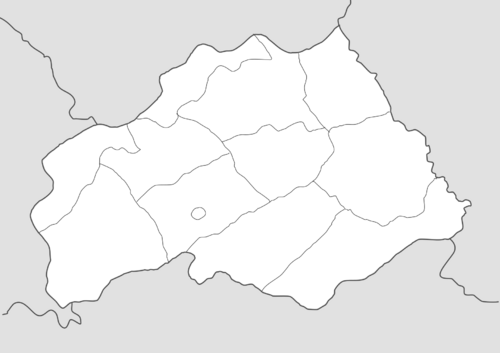
Administrative divisions
Chanda is divided into 11 Provinces, known as Aimags, which are in turn divided into 381 Districts. Each province is headed by an regional governor appointed by the president as well as a regional legislature elected by the Districts. While each province has some autonomy, ultimately they are subservient to the national government and largely serve to coordinate the implementation of national policies in the region. The capitol city of Taglikend has status of "state importance" and do not belong to any region.
Chanda have no formal second-level subdivisions below provinces. However Districts may form partnerships and other aggreements with each other to promote cooperation, espeically within populated cities. The People's Districts of Chanda are the smallest level of administration, equivalent to a municipality; however larger cities may have multiple governments. The main institution of the District is the Local People's Council, consisting of a 11 member council which is responsible for the District. ALongside the Council is the Local People's Assembly consisting of directly elected members and any voters from the respective functional constitency. Allowing voters to participate effectively turns it into a forum for their local community, allowing them to propose laws, decide some government spending, submit a report of current issues, and more. While the LPC and the LPA are the main authority, they are assisted by the Local People’s Committee which implements policies and ordinances proposed by the two other bodies.
Foreign relations
According to the Declaration of the Birlikist Republic, the Supreme Council of the Republic is ultimately responsible for conducting foreign policy. However in practice the President of Chanda, who directs the Ministry of Foreign Affairs, is de facto in charge. In addition, the power of oversight has been shifted to the National Assembly, who must approve the President's decisions. The Supreme Council's role has largely been reduced to formally accrediting foreign diplomats and ratifying those treaties already approved by the Assembly.
Chanda is a member of three Senrian-led regional organizations, the Bashurat Cooperation Organization, the Sangang Mutual Security Organization, and the Council for Mutual Development. It depends on the SAMSO military alliance for security and COMDEV for economic ties. It is also a member nation of the Community of Nations and the International Trade Organization.
Chanda is closely allied with Senria and its fellow member states in the regional organizations. It especially has close economic ties with Baekjeong, as Chanda relies on its neighbor for access to the global economy. Chanda has very poor relations with Ajahadya and Xiaodong who both claim parts of Chanda's territory. Chanda has fought Ajahadya twice during the Satrian Wars; Chanda lost Inner Himavanta to Ajahadya in the Second Satrian War in 1960 and regained it after the Third Satrian War.
Armed forces
Chanda's armed forces has two major branches; the Chandan People’s Defence Force, which is split into the Ground Force, Air Force, and the Total Defence Force and the People's Liberation Army, which is split into the Kharuul, Labour Corps, and the Engineer Corps. Although the Defence Force is concerned with external defence and the Army is focused on internal affairs, the interservice rivalry between the two is intense. As a result, there is a level of redundancy and overlapping authority in the Armed forces such as between the Ground Force, Total Defence Force, and the Karhuul.

The People's Defence Force currently consists of 100,000 total troops; 50,000 of which are active members, 30,000 who are in reserve, and 20,000 who are members of various paramilitaries. The President is commander-in-chief of the Force, which answers to them via the Ministry of Defence. Military matters are directly handled by the High Command, a forum of military commanders and advisors who part of the Ministry of Defence. The Force originates from the various militia groups that operated separately of the People's Liberation Army during the West Shalegho Commandery. After the Establishment of the Republic, they were reorganized into a more coherent force, known as the People's Army although the it continued to lack a centralized command. The issues of having a decentralized military and lack of modern equipment manifested in the country's defeat in the Second Satrian War. In the late 1960s, Chanda reformed its military by restructuring it into a more professional and centralized force. Various modernisation programs were completed throughout the 1970s and 1980s, by purchasing weapons from Senria and Baekjeong.

On paper the People's Liberation Army has over 500,000 personnel, making it equivalent to the armed forces of its larger neighbors. In reality no personnel are capable of fighting; the Karhuul function as law enforcement and the Corps act as laborers, engineers, and other workers. As a result, instead of military defence the Army is a critical part of the Chandan economy by running factories, supplying workers, and constructing public works. Unlike the Defence Force, the Army is largely independent and does its own decision making in economic affairs. Despite its indepedence, the Army still reports to the Supreme Council, although in practice the Council relays orders from the President. Its unique structure and operation is the result of its origin as a Pardal milita that controlled the West Shalegho Commandery from 1935 to 1951. The Army's involvement in Commandery's domestic affairs was significant, and it continued in Chandan society even after the Republic was established. As a result, the Army controls a large part of the economy and wields much influence in politics.
Economy
Agriculture
Industry
Services
Infrastructure
Energy
Demographics
The country is the least populated country in Satria, with its population estimated to be around 28 million people in 2021. The annual growth rate, calculated by the last census in 2018, was reported to be 1.45%. The total fertility rate is estimated to be 1.7 children per woman, which continues a declining trend over the last couple decades. However the median age of the country is 23.6 years old with the majority of the country below 30 years old. There is an estimated 102.3 males for every 100 females in 2021. The average life expectancy is 72.2 years, with 69.2 years for men and 75.5 years for women.
The majority of Chanda's population live in the Chandan Plateau in an arched region stretching from the western end of the Gurkhan Pass to the northeast of the country, known as the Corridor. The country's largest cities, including Taglikend, Chanda's capitol and most populated city are within this region. Other major population centers are in the Lowlands near Ajahadya, and the southern Gurkhan Pass in the south. The population density is 168/km2 (435.1/sq mi) and 63% of the population lives in an urban center.
Ethnicity
Chanda is widely considered to be multiethnic country with diverse origins due to migrations that occurred over the last thousand years. The people of Chanda are divided into four general ethnic categories; Bashtugin, Satrian, Xiao, and Other, which are in turn divided into specific ethnic groups. There is significant intermixing between between these ethnic groups, since the majority of these groups live in the same regions as each other. Ethnic information is collected by the Ministry for Harmony every ten years, which are used to determine ethnic policies in a variety of issues such as political participation, public housing and education. Since the 1990s, citizens are allowed to state a primary ethnic identity and a secondary ethnic identity; approximately 20% of Chandans identify this way, especially among the younger generations.
Ardagali, or people of Bashtugin descent, make up 48.9% of the population. While the term usually refers to people who are directly descended from the Bashtugins who settled the region during the reign of the Togoti Khaganate, it also refers to the indigenous people that assimilated into the old Bashtug culture. The Chandan government does not distinguish between ethnic Ardagali and assimilated ones, although it is estimated that at least one-third of Ardagali peoples are of Satrian origin.
Around 30% of the population, about 8.4 million people, are Satrians who can trace their ancestry to the various tribes that inhabited the region before the arrival of the Togoti Khaganate. The largest Satrian group is the Himavantans who make up a majority of the northwest region and 9.7% of the country's population. For the Dogra, Aholisi, Sarati, and Brahvi, they are scattered across the region but often constitute a majority of the population in rural areas. While most of the Satrian groups always had distinct identities, the Sarati did not see themselves as a distinct ethnic group until the 1960s. Based upon their cultural traits, the Sarati are considered to be a mix of Bashtugin and various Satrian peoples. For this reason, the Sarati are sometimes categorized as Bashtugin.
About 18% of the population, around 5.2 million people, are Xiaodongese or Xiao as they are officially called by Chanda. They mostly live south of the West Shalegho mountains but also in the Gurkhan Pass. Geographically the region south of the Shalegho mountains are part of South Coius which reflects the region's Xiaodong's historical control over the region for hundreds of years. Chandan Xiaos, especially those in the Gurkan Pass, have some Bashtugin and Satrian influences, but generally aren't culturally distinct with their counterparts in Xiaodong. As a result, the Chandan Xiaos are a major source of ethnic tension in the region and strained relations with Xiaodong.
The last ethnic category are "Others", which largely consist of half a million Baeans. The remaining 200 thousand people include Eucleans, and other Coians such as South Coians, Southeast Coians, Rahelians, and Bahians.
Languages
The official languages of Chanda are Chandan, Ardagala, Xiaodongese, Himavantan, and Dogra. The remaining Satrian languages are recongized minority languages.
Chandan is the lingua franca and national language designated by the Chandan government. The Chandan language is an constructed auxiliary language language adopted and standarized by the government in the 1950s. While its primarily based on Ardagala, it features simplified grammar and additional common loanwords from various Satrian languages in Chanda. Chandan is written in a Satrian script, as are all other recognized languages, except Xiaodongese. It is used to communicate in business, government, law and education, and the use of other official languages for these situations are heavily discouraged.
Chandan citizens are mostly bilingual, with Chandan as their common language to communicate with other Chandans and their mother-tongue based upon their own ethnic identity. Although it was not intended to be used out of formal communication, the Chandan language has become the primary language for a growing number of people. As a result, the language has begun to change significantly as the use of it as a primary language grows. In addition the Chandan language has begun to influence the vocabulary of other languages in Chanda, especially the Ardagala language, and vice versa. Around 12.3% of the people in Chanda, use the Chandan language as their primary language.
The most common language is Ardagala, used by ~40% of the population. It is a Bashtugin language with significant influences from the Satrian languages of the region. The pronunciation and vocabulary of Ardagala has diverged somewhat from the modern Togoti language as a result of Satrian influence. Like the Chandan language, it contains many Satrian loanwords, but it continues to maintain vowel harmony and grammar found in other Bashtugin languages. Despite its common use, Ardagala is discouraged from used official government and business functions.
The next most common is Xiaodongese, which is mostly spoken in the south of the country by their namesake culture. Even though it is an official language, the use of the Xiaodongese language is tolerated but unoffically discouraged by the Chandan government in nearly all situtations, in an attempt to supress Xiaodongese seperatism. It continues to be a major source of tension in the country.
The various Satrian languages are spoken by their constituent ethnic group. Himavantan is the most widely spoken Satrian language spoken in the north of the country. Despite the recongition of these languages by central government, the use of the other Satrian languages have declined as the use of Chandan continues to be promoted by the central government. The government has not made any attempt to halt the languages' decline or to preserve them, leading to fears that these languages may become endangered and possibly extinct.
Religion
Largest cities
Education
The Chandan government has full authority over the country's education system and curriculum, although the provincial governments have some authority to monitor. Education is free and is compulsory from the ages of 5 to 18, although students have the option at 16 to join the workforce through an apprenticeship. The standard school year runs from mid August to late May with some regional variations. The Ministry of Education and the provincial Educational Offices work in cooperation to ensure the quality of education. Homeschooling is an option for students who have severe behavioural or learning difficulties or would be impeded by placement in a school.
Optional kindergarten education is provided by various organisations for all children between two and five years old. Primary education, lasts for five years, which beings at five years of age and ends with students graduating at ten. The school first concentrates on teaching student basic knowledge, skills, and activities before shifting to gauging a student’s abilities. A test administered before graduation will measure a student’s cumulative abilities.
Secondary education is broken into two parts; the General School for general education from ten to fourteen years old and two separate specialised schools from fourteen to eighteen. The High School is for talented and intelligent students, which emphasises academic learning and preparation for universities. Students can also go to a Vocational School, which teaches a student the skills for a particular job. Otherwise they can remain in the Hauptschule until graduation. They also offer artistic, gymnasium, and vocational classes. The General School also offers a variety of courses designed to prepare students with essential skills for adulthood. These include learning to pay various taxes and bills, driving a car, gun safety, and culinary classes.
There are 12 universities and over 100 colleges for tertiary education in the country. It is divided into vocational technicals and academic universities. Admission is free for students applying to technicals and universities who have an above average grade. Below that students must pay the admission fee.