Khatax: Difference between revisions
No edit summary |
m (1 revision imported) |
(No difference)
| |
Revision as of 20:37, 28 January 2019
Khatax | |
|---|---|
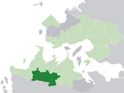
 Khatax (dark green) in the Kingdom of Trellin (light green) | |
| Nation | Trellin |
| Capital | Gerint |
| Population (2013) | |
| • Total | 3,150,602 |
| Demonym | Khataxan |
Khatax (pronounced /ˈxætæks/), officially the Territory of Khatax (Trellinese: Malaha Khataxa), is a province of the Trellinese Empire. It is the seventh-least populous province in Trellin and Hysera and the largest by area.
Clockwise from the northwest, Khatax borders with Mevirin, Azmir, Aurelia, Ternos, Më'idan and Rezat. The province has a population of 3,150,602 and covers a total area of roughly 153,700 square kilometres. The seat of provincial government is at Gerint, in the east of Khatax.
Geography
The province of Khatax covers a total area of 153,712.51 square kilometres, according to the Imperial Geographical Survey, making it the largest territory of the empire. It is the only landlocked province in Trellin's southern landmass, sharing borders with Aurelia to the south and the provinces of Azmir, Mevirin, Ternos, Rezat and Më'idan. Its western border, with Azmir, is defined principally by the line of the river Ruhükyar and lakes Timenava and Uzarnet.
Khatax experiences a steppe climate throughout most of its landmass, giving it large tracts of grass and scrubland. Towards the Aurelian border, the land rises to hills and and the mountains of the Toron Kimruin. A substantial rain shadow in this region creates tracts of dry desert along the border.
Between the 1970s and 1990s, intensive agriculture and overgrazing caused extreme soil degradation and facilitated the encroachment of sandy desert over what had once been grassy terrain. A large grassroots movement, the Gerint Gardeners' Association, was established in 2014 to reverse this trend. The GGA's efforts earned it a royal commendation in 2015.[1]
History

Before the 1780s, Khatax was largely terra nullius, though the Margraviate of Azmir claimed some land east of the Ruhükyar while Rezat administered a portion, known as the Marhira Triangle, between the headwaters of the Etsakha and Marhira. An imperial edict issued by Azara IV in 1784 asserted the Sidereal Crown's claim over the entire unoccupied region between Trellin and Aurelia and opened the area to settlement. Maps of the empire began including it as the Malaha Khataxa (Khataxan Territory), extending as far as the Aurelian border, but colonisation on a large scale did not begin until 1788, when Jajexan land-owner and real estate entrepreneur Nürial Rismikhar purchased 7,000 acres of land along the Rëosana. Rismikhar founded a city on this site which he named after the earl of Jajich, Gerint Tozaln.
Gerint quickly grew to become the main commercial hub in the new territory, as its situation allowed it to control the greater part of riverine trade in the central and eastern Khatax. By 1800 its population had swelled to over 10,000, and it was de facto the administrative capital of the territory. It received legal recognition in this role from the monarchy in 1804, at the same time as a new port was built to conduct trade with the Velaran ports, as Gerint was quickly becoming a major centre for the flow of agricultural produce outward to the rest of the empire. The city was also a major entry point for settlers travelling to the rest of the territory, purchasing land from the crown for prices which were then phenomenally low.
In 1825, Khatax's borders were adjusted to include the Rezati Marhira Triangle and a strip of land between Mevirin and Rezat west of the Tenici river.
References
- ↑ Lezalm, Esamin, "Queen Azara: "God bless the GGA"", The Sidereal Herald, 28 July 2015. Retrieved on 24 November 2015.


