Zanzali: Difference between revisions
No edit summary |
|||
| Line 126: | Line 126: | ||
== Geography and climate == | == Geography and climate == | ||
[[File:Climate map of Zanzali.png|left|thumb|250px|{{wp|Köppen climate classification|Köppen climate types}} of Zanzali.]] | |||
Zanzali is approximately 713,600km<sup>2</sup> (275,523 square miles) in area, located on the southern shore of the [[Karaihe Sea]] in southeastern Malaio. It borders [[Onekawa-Nukanoa]] to the east, along the [[Hanaki River]] and accompanying swamplands, and the [[Javinassa peninsula]] of [[Pulau Keramat]] to the north, where the border is partially defined by the Javinassa Mountains. | Zanzali is approximately 713,600km<sup>2</sup> (275,523 square miles) in area, located on the southern shore of the [[Karaihe Sea]] in southeastern Malaio. It borders [[Onekawa-Nukanoa]] to the east, along the [[Hanaki River]] and accompanying swamplands, and the [[Javinassa peninsula]] of [[Pulau Keramat]] to the north, where the border is partially defined by the Javinassa Mountains. | ||
Zanzali's physical features are characterized by the dichotomy between the wet, {{wp|tropical monsoon climate|tropical}} coast in the north and the {{wp|semi-arid climate|semi-arid}}, rugged southern interior. {{wp|Southern Zanzibar–Inhambane coastal forest mosaic|Southern Karaihe coastal forests}} are broken up by coastal swamplands, particularly {{wp|East African mangroves|East Malaioan mangrove forests}} and {{wp|Zambezian coastal flooded savanna|Mzanzi flooded savanna}}, host thousands of diverse plant and animal species and support extensive fishing, agriculture, and tourism industries. The [[Koo River|Koo]], [[Mbizi River|Mbizi]], [[Ndzeya River|Ndzeya]], and [[Hanaki River|Hanaki]] rivers (listed west-to-east by the location of their estuaries) are the country's principle waterways, meandering north from the interior hills into the Karaihe Sea, creating numerous lakes, swamps, and floodplains along the way. The Hanaki river is Zanzali's widest river, spanning 22 kilometers (13.6 miles) across at its widest point, while the Koo River is the longest, winding 1220 kilometers (695 miles) from Lake Ntsiɗwe on the country's southwestern border to its outlet near the city of Waguguru. | Zanzali's physical features are characterized by the dichotomy between the wet, {{wp|tropical monsoon climate|tropical}} coast in the north and the {{wp|semi-arid climate|semi-arid}}, rugged southern interior. {{wp|Southern Zanzibar–Inhambane coastal forest mosaic|Southern Karaihe coastal forests}} are broken up by coastal swamplands, particularly {{wp|East African mangroves|East Malaioan mangrove forests}} and {{wp|Zambezian coastal flooded savanna|Mzanzi flooded savanna}}, host thousands of diverse plant and animal species and support extensive fishing, agriculture, and tourism industries. The [[Koo River|Koo]], [[Mbizi River|Mbizi]], [[Ndzeya River|Ndzeya]], and [[Hanaki River|Hanaki]] rivers (listed west-to-east by the location of their estuaries) are the country's principle waterways, meandering north from the interior hills into the Karaihe Sea, creating numerous lakes, swamps, and floodplains along the way. The Hanaki river is Zanzali's widest river, spanning 22 kilometers (13.6 miles) across at its widest point, while the Koo River is the longest, winding 1220 kilometers (695 miles) from Lake Ntsiɗwe on the country's southwestern border to its outlet near the city of Waguguru. | ||
Annual monsoons from May to November inundate coastal regions, with some areas receiving more than 1500 milimeters (60 inches) of rain annually. While the rainy season is also, on average, the warmer part of the year, it is rare for temperatures on the coast to deviate much outside of the range of 25°C-30°C (77°F-86°F). Moving away from the coast, there is a rapid transition to tropical savanna and {{wp|Eastern miombo woodlands|miyombo woodlands}}, accompanied by a rise in elevation. This rise means that most major waterways were not fully navigable, due to rapids and waterfalls, until the construction of a system of locks and canals in the 20th century. | Annual monsoons from May to November inundate coastal regions, with some areas receiving more than 1500 milimeters (60 inches) of rain annually. While the rainy season is also, on average, the warmer part of the year, it is rare for temperatures on the coast to deviate much outside of the range of 25°C-30°C (77°F-86°F). Moving away from the coast, there is a rapid transition to tropical savanna and {{wp|Eastern miombo woodlands|miyombo woodlands}}, accompanied by a rise in elevation. This rise means that most major waterways were not fully navigable, due to rapids and waterfalls, until the construction of a system of locks and canals in the 20th century. | ||
| Line 159: | Line 159: | ||
|A boat floats near shallow coral reefs in Waguguru. | |A boat floats near shallow coral reefs in Waguguru. | ||
}} | }} | ||
== History == | == History == | ||
Revision as of 06:00, 30 December 2021
| Motto: "ఇల్లీ వాన్తరు అంవెసఁ వాక్యాంటీసి హోంకిఫులి." "Ili wanatru amwesa wakantsi hokifuli." "So that our children may sit in the shade." | |
| Anthem: కుంద్రావి వా కేరహి 'Kundravi wa Kerahi' ("Jewel of the Karaihe") | |
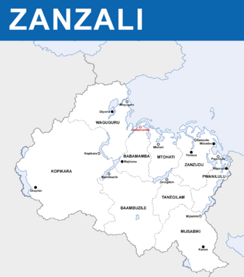
 Political Map of Zanzali | |
| Capital | Babamamba |
| Largest city | Zanzudu |
| Official languages | ShiMzanzi |
| Recognised regional languages | |
| Ethnic groups | |
| Religion | List of religions
|
| Demonym(s) | Mzanzi (sing.) WaMzanzi (pl.) |
| Government | Kritarchy with democratic and aristocratic characteristics |
| Zuwena binwa Mahiri | |
• Bendhara | Dana mwawa Endeleya |
| Mzuzi mwawa Sartika | |
| Legislature | Fukoshauri |
| Waswiya Mabadi | |
| Ɓaɓada | |
| Independence from the Mutul | |
• Tahamaja colony | 936-1353 CE |
• Pirate republics | 1353-1695 |
• Maok'ab client state | 15 September 1695 - 23 March 1841 |
• Madarakate | 23 March 1868 - present |
| Area | |
• Total area | 713,600 km2 (275,500 sq mi) |
• Water (%) | 9 |
| Population | |
• 2020 census | 21,753,300 |
| GDP (nominal) | 2020 estimate |
• Total | $746,138,190,000 |
• Per capita | $34,300 |
| Gini (2020) | medium |
| HDI (2020) | very high |
| Currency | biya (Z฿) (ZZP) |
| Time zone | UTC+2 |
| Date format | dd/mm/yyyy |
| Driving side | right |
| Calling code | +258 |
| Internet TLD | .ZZ |
Zanzali (/zɑːnzɑːliː/; ShiMzanzi: త్సణ్డజాలే, Tsandzale), officially the Madarakate of Zanzali (ShiMzanzi: మదరకత త్సణ్డజాలే, Madarakata Tsandzale), is a country in southeastern Malaio situated on the Karaihe Sea, bordering Pulau Keramat to the north and Onekawa-Nukanoa to the east. Its population of 21,753,300 is among the smallest in Malaio and concentrated on the tropical coast, with much of the rest of its 713,600km2 area being arid relatively sparsely populated. The capital of Zanzali is Babamamba, while the largest city is Zanzudu. Its majority and official language is ShiMzanzi, the southernmost Mwambao language.
For much of prehistory, Zanzali was occupied by Tuganani peoples, who would eventually be pushed out of the region, or otherwise assimilated, by Komontu migrants who began arriving en mass in the early 500s CE. Beginning in the 10th century CE, the area that is now Zanzali was utilized as a penal colony by the Tahamaja Empire, where criminals and dissidents from throughout the Ozeros region were sent to work mining gemstones and growing coffee and nuts alongside local Komontu and Tuganani tribes. The mixing of these groups gave rise to the WaMzanzi, which today are the largest group in Zanzali. This constant influx of criminal elements led to the region becoming known for its skilled mercenaries, smugglers, and pirates, who eventually became the main authorities in Zanzali after the collapse of the Tahamaja in the 1300s, leading to the rise of many pirate republics in the region. These republics came under the suzerainty of the Mutulese Yajawil of Maok'ab by the late 17th century. In 1841, the Mzanzi republics gained their independence from Maok'ab, and joined in 1863 under a union of religious courts which would evolve into the modern state.
Zanzali's political history has been defined by a unique system of rule by religious judges, called unamuzi, and a "big man" dynamic characterized by spectacle. The Madaraka is offically a unitary state which practices heavy devolution across 9 viceroyalties. Power is balanced between the central judiciary, aristocratic clans, and popular petitions and referenda. Zanzali is a minor power and a member of many international organizations, such as AMON, the Forum of Nations, and the Joint Space Agency. Its economy is highly developed, with a GDP per capita of $34,300, with its major industries including tourism, pharmaceutical and chemical production, and entertainment. Industrial agriculture and food processing is also a major component of the economy, with coffee, seafood, tobacco. and spices, particularly vanilla, being mainstays. Despite a relatively strong economy and high HDI of .804, Zanzali is known for its high income inequality, with a GINI coefficient of 44.3. Likewise, while it ranks well in many international comparisons of quality of life, Zanzali has been criticized for its lack of human rights protections and inconsistent public services.
Etymology
The name Zanzali is derived from the Middle ShiMzanzi word tsandzale (coast), which remains the native name for the country. This word was understood by Tahamajan authorities to be the native name for the region, but there is no historical evidence for its use in this context before the 13th century, records of which primarily come from Tahamajan documents. Other historical names include Zanzudu ("black coast"), Ikomwii ("bad shore"), and Waguguru (from mguguru, "stubborn, brutal"), all reflecting Tahamajan attitudes towards the area's inhabitants.
A person from Zanzali, or a member of its dominant ethnic group, is called an Mzanzi (/əmzɑːnziː/), the plural being WaMzanzi (/wɑːˈ-/).
"Madarakate" entered usage as a formal national title in 1868, being coined a century earlier to describe realms overseen by monastaries and judges, as opposed to Mutulese batabs. It comes from the ShiMzanzi word madaraka, literally "obligations, arrangements", and evokes the cultural and religious responsibilities upon which the Mzanzi state are based.
Geography and climate

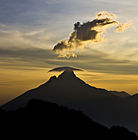
Zanzali is approximately 713,600km2 (275,523 square miles) in area, located on the southern shore of the Karaihe Sea in southeastern Malaio. It borders Onekawa-Nukanoa to the east, along the Hanaki River and accompanying swamplands, and the Javinassa peninsula of Pulau Keramat to the north, where the border is partially defined by the Javinassa Mountains.
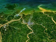
Zanzali's physical features are characterized by the dichotomy between the wet, tropical coast in the north and the semi-arid, rugged southern interior. Southern Karaihe coastal forests are broken up by coastal swamplands, particularly East Malaioan mangrove forests and Mzanzi flooded savanna, host thousands of diverse plant and animal species and support extensive fishing, agriculture, and tourism industries. The Koo, Mbizi, Ndzeya, and Hanaki rivers (listed west-to-east by the location of their estuaries) are the country's principle waterways, meandering north from the interior hills into the Karaihe Sea, creating numerous lakes, swamps, and floodplains along the way. The Hanaki river is Zanzali's widest river, spanning 22 kilometers (13.6 miles) across at its widest point, while the Koo River is the longest, winding 1220 kilometers (695 miles) from Lake Ntsiɗwe on the country's southwestern border to its outlet near the city of Waguguru.
Annual monsoons from May to November inundate coastal regions, with some areas receiving more than 1500 milimeters (60 inches) of rain annually. While the rainy season is also, on average, the warmer part of the year, it is rare for temperatures on the coast to deviate much outside of the range of 25°C-30°C (77°F-86°F). Moving away from the coast, there is a rapid transition to tropical savanna and miyombo woodlands, accompanied by a rise in elevation. This rise means that most major waterways were not fully navigable, due to rapids and waterfalls, until the construction of a system of locks and canals in the 20th century.
The southern half of the country consists mostly of semi-arid hills, featuring mopane woodlands in the river valleys and drier interior miyombo woodlands in elevated areas. Temperatures are typically similar to the coasts, but rain is much scarcer, with most areas receiving less than 500 milimeters (20 inches) of precipitation annually. This hot, dry hinterland is broken up by high plateaus featuring a contrasting subtropical temperate climate, hosting montane forests and grasslands. Temperatures are comparatively mild and consistent year-round in these regions, usually staying between 10°C-22°C (50°F-76°F). These highlands are the southern terminus of the larger Great Malaioan Rift, a system of lakes, mountains, and highlands running the length of the continent.
Zanzali is also on the southern edge of the Karaihe Ecological Intermediate Zone, a transitional area wherein three distinct biogeographical regions meet: the Malaio Rift savannas, the Ozeros tropical rainforests, and the Onekawan temperate woodlands, all centered around the Karaihe Coral Archipelago, a group of atolls and coral reefs throughout the Karaihe Sea which form one of the largest concentrations of coral and marine life in the world, protected by the internationally-administrated Karaihe International Marine Preserve. The Intermediate Zone features diverse flora and fauna from each of these regions, and Zanzali in particular hosts giraffes, both Ozerosi and Malaioan elephants, rhinoceroses, and other animals which contributes to a thriving eco-tourism sector and zoological community.
History
Tahamaja period
Majambazi period
majambazi majini ("water thieves")


