Bay of Montecara: Difference between revisions
No edit summary |
No edit summary |
||
| (21 intermediate revisions by 2 users not shown) | |||
| Line 1: | Line 1: | ||
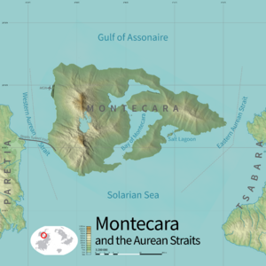
[[File:MC-topographic.png|300px|thumbnail|Bay of Montecara at center]] | |||
[[File:MC- | |||
The '''Bay of Montecara''' ([[Montecaran language|Montecaran]]: ''ia Bàia de Montecara'') is a body of water nearly surrounded by the main island of [[Montecara]]. | The '''Bay of Montecara''' ([[Montecaran language|Montecaran]]: ''ia Bàia de Montecara'') is a body of water nearly surrounded by the main island of [[Montecara]]. | ||
== Geology == | == Geology == | ||
The bay was | [[File:Kotor and Boka kotorska - view from city wall.jpg|thumb|left|The upper bay]] | ||
The bay was formed by the {{wp|pyroclastic flow}} of the now-extinct volcano [[Monte Cara]]. It is notably deep for its relatively small area, and its unusually cold water by the standards of the region makes it attractive to fish, making it known for its abundant sea life. The deep channel also makes it accessible to shipping. | |||
The upper part of the bay is relatively narrow with steep sides, leaving room for only a small rim of settlement around its edges in parts. | |||
== Geography == | |||
[[File:Isolasanmichele.jpg|thumb|The island of Oçì]] | |||
The bay covers an area of 137.8 square kilometers. The outlet to the [[Solarian Sea]] is 1.5 kilometers across, and the passage between the lower and upper bays is the narrowest point of the entire body of water at 850 meters across. Its mean depth is approximately 30 meters, and it is approximately 80 meters deep at its deepest. | |||
The bay has only one island of any size, [[Oçì]], which is home to approximately 100 monks who belong to a monastic community that has been established there for over a thousand years. It is closed to the public except on designated holidays during which a special ferry service stops there. The island has an area of {{convert|14.38|ha|km2|sigfig=2}}. | |||
== Port == | |||
The bay is a vast {{wp|natural harbor}} whose usefulness to seafarers has been recognized for millennia. It makes up the main part of the [[Port of Montecara]], with moorings and facilities for commercial, private, and military vessels. | |||
{{Template:Montecara topics}} | {{Template:Montecara topics}} | ||
[[Category:Bodies of water (Kylaris)]] | |||
[[Category:Montecara]] | [[Category:Montecara]] | ||
Latest revision as of 18:53, 27 March 2023
The Bay of Montecara (Montecaran: ia Bàia de Montecara) is a body of water nearly surrounded by the main island of Montecara.
Geology
The bay was formed by the pyroclastic flow of the now-extinct volcano Monte Cara. It is notably deep for its relatively small area, and its unusually cold water by the standards of the region makes it attractive to fish, making it known for its abundant sea life. The deep channel also makes it accessible to shipping.
The upper part of the bay is relatively narrow with steep sides, leaving room for only a small rim of settlement around its edges in parts.
Geography
The bay covers an area of 137.8 square kilometers. The outlet to the Solarian Sea is 1.5 kilometers across, and the passage between the lower and upper bays is the narrowest point of the entire body of water at 850 meters across. Its mean depth is approximately 30 meters, and it is approximately 80 meters deep at its deepest.
The bay has only one island of any size, Oçì, which is home to approximately 100 monks who belong to a monastic community that has been established there for over a thousand years. It is closed to the public except on designated holidays during which a special ferry service stops there. The island has an area of 14.38 hectares (0.14 km2).
Port
The bay is a vast natural harbor whose usefulness to seafarers has been recognized for millennia. It makes up the main part of the Port of Montecara, with moorings and facilities for commercial, private, and military vessels.


