Rezat: Difference between revisions
m (Text replacement - "Më'idan" to "Mëhidan") |
mNo edit summary |
||
| Line 21: | Line 21: | ||
| subdivision_type1 = | | subdivision_type1 = | ||
| subdivision_name1 = | | subdivision_name1 = | ||
| established_title = | | established_title = | ||
| established_date = | | established_date = | ||
| Line 35: | Line 31: | ||
| leader_name = | | leader_name = | ||
| unit_pref = Metric | | unit_pref = Metric | ||
| area_note = | | area_note = | ||
| area_water_percent = | | area_water_percent = | ||
| Line 56: | Line 45: | ||
| area_blank1_km2 = | | area_blank1_km2 = | ||
| area_blank2_km2 = | | area_blank2_km2 = | ||
| length_km = | | length_km = | ||
| width_km = | | width_km = | ||
| Line 96: | Line 76: | ||
==Geography== | ==Geography== | ||
The Rezati coastline is defined by chiefly by the large peninsula of Arnyü's Finger and the deep V-shaped bay to its immediate west, at the angle of which the [[Etsakha]] enters the sea. North of Arnyü's Finger is the island of [[Morikz]], the fifth largest island in the Sea of Velar. The [[Prosperity Hills]], in the southwest of the province, were historically a major source of silver. | The Rezati coastline is defined by chiefly by the large peninsula of [[Arnyü's Finger]] and the deep V-shaped bay to its immediate west, at the angle of which the [[Etsakha]] enters the sea. North of Arnyü's Finger is the island of [[Morikz]], the fifth largest island in the Sea of Velar. The [[Prosperity Hills]], in the southwest of the province, were historically a major source of silver. | ||
===Flora and fauna=== | ===Flora and fauna=== | ||
Latest revision as of 01:44, 29 January 2023
Rezat | |
|---|---|
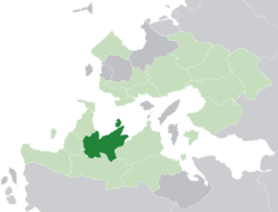
 Rezat (dark green) in the Kingdom of Trellin (light green) | |
| Nation | Trellin |
| Capital | Halith |
| Population (2013) | |
| • Total | 4,782,629 |
| Demonym | Rezati |
| Area code(s) | 067 |
Rezat (pronounced /rɛˈzæt/), officially the Fiefdom of Rezat (Trellinese: Tavesan Rezatai), is a province of the Trellinese Empire. It is the eighth-least populous province in Trellin and Hysera and the twelfth largest by total area.
Rezat borders Bal Emrith and Mevirin in the west, Khatax in the south and Mëhidan in the east, and is bounded to the north by the Sea of Velar. It also shares a border with the Trophy Port of Vacoas on the island of Morikz. Rezat has a population of 4,782,629 and covers a total area of 102,843.62 square kilometres. The province's capital is at Halith.
Despite Rezat's size, it is sparsely populated, with most population centres hugging the coast and the river Etsakha. Two fifths of the total population lives on Morikz.
Geography
The Rezati coastline is defined by chiefly by the large peninsula of Arnyü's Finger and the deep V-shaped bay to its immediate west, at the angle of which the Etsakha enters the sea. North of Arnyü's Finger is the island of Morikz, the fifth largest island in the Sea of Velar. The Prosperity Hills, in the southwest of the province, were historically a major source of silver.
Flora and fauna
The Rezati leopard lives here and jays lads is it goofy with the face on it and them gammy legs.

