Sahra: Difference between revisions
(Creating Sahra) |
No edit summary |
||
| Line 97: | Line 97: | ||
{{wip}} | {{wip}} | ||
{{TOC limit|2}} | {{TOC limit|2}} | ||
== Geography == | |||
{{multiple image | |||
| align = right | |||
| total_width = 300 | |||
| image_style = border:none; | |||
| title = | |||
| perrow = 2/1 | |||
| caption_align = center | |||
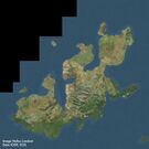
| image1 = Satellite image of Orioni.jpg | |||
| caption1 = Satellite image of Orioni. | |||
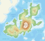
| image2 = Physical map of Orioni.png | |||
| caption2 = Physical map of Orioni. | |||
}} | |||
[[File:Rioni river - Georgia (Europe).jpg|200px|thumb|left|River in the [[Mendakh Mountains]].]] | |||
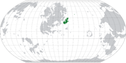
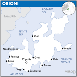
Orioni is located at the easternmost region of [[Europa (continent)|Europa]], separated from the Europan mainland by the [[#geography|Tethys Sea]] and along the [[Oriental Ocean]]. At 1,155,853 km2 (446,277 sq mi), according to the [[Assembled Nations|AN]] [[List of countries on Eurth by area|Geographic Yearbook]], Orioni is the 2nd-largest country on [[Eurth]]. It is slightly larger than [[Volsci]], twice the size of [[Tamurin]], three times as big as [[Variota]], four times the size of [[Batengdei]] and five times the size of the [[Seylos]]. The main island, also called the “Home Island", is divided into three parts: western {{wp|Alnitak}} where the majority of the Orinese population lives, central Alnilam is dominated by the Mendakh mountains, and northeastern {{wp|Almintaka}} forms a sparsely inhabited nature preserve. Besides the main island, there are also 430 smaller islands, of which the larger ones are being inhabited and others remain uninhabited. To the west of [[Nordhaven]] lies Deseti island, which hosts the headquarters for the [[Entente of Oriental States]]. To the southeast of [[Oris]] lies {{wp|Malindi}} island which is presently occupied by [[Miiros]]. | |||
[[Natural Wonders of Eurth|Mount Silesto]] in Amilaki at 3,450 m (11,320 ft) is the highest peak in Orioni. Excluding the [[Rohini]] and [[Burkini]] islands, the country lies between latitudes 15° and 31°N, and longitudes 135° and 152°E. It is south of [[Ide Jima]], separated by the [[#Geography|Rosario Sea]]; and north of [[Niederoestereich]], separated by the [[#Geography|Azure Sea]]. The closest neighbouring country to Orioni is the [[Tamurin]] republic westward across the [[#Geography|Roavia Strait]]. Orioni maintains maritime claims on the {{wp|continental shelf}} of 200 m depth or to the depth of exploitation. Its {{wp|territorial sea}} extends 12 {{wp|nautical miles}} (22,2 km or 13,8 mi) with an {{wp|exclusive economic zone}} of 200 nautical miles (370 km or 230 mi). The northernmost point is Cape Tawiseni extending into the [[#Geography|Rosario Sea]], [[#Administrative divisions|Mar province]] (30°57'N). The easternmost point is {{wp|Amrita|Cape Amrita}} on the [[#Geography|Deli peninsula]], [[#Administrative divisions|Meda province]] (152°04'E). The southernmost point is an unnamed point in one of the shifting sandbanks of the Wenizi {{wp|river delta}} at low tide, [[#Administrative divisions|Zuidhaven province]] (15°29'N). The westernmost point is {{wp|Cape Suzette}}, [[#Administrative divisions|Sirius province]] (134°54'E). | |||
=== Landscape === | |||
{{Pie chart | |||
| thumb = left | |||
| caption = <center>'''Land use'''</center> | |||
| other = | |||
| label1 = Arable land | |||
| value1 = 16 | |||
| color1 = #ffcc00 | |||
| label2 = Permanent crops | |||
| value2 = 15 | |||
| color2 = #003380 | |||
| label3 = Permanent pastures | |||
| value3 = 10 | |||
| color3 = #AE0B0B | |||
| label4 = Forest and woodland | |||
| value4 = 53 | |||
| color4 = #808080 | |||
| label5 = Other | |||
| value5 = 6 | |||
| color5 = #1673FF | |||
}} | |||
{{multiple image | |||
| align = right | |||
| total_width = 350 | |||
| image_style = border:none; | |||
| title = Geographical features of Orioni | |||
| perrow = 2/3/3 | |||
| caption_align = center | |||
| image1 = Monteverde_puente.jpg | |||
| caption1 = Canopy walkway in the tropical forest of Alnitak. | |||
| image2 = Eri_landscape.jpg | |||
| caption2 = Mixed woodland-grassland ecosystem in Irisha. | |||
| image3 = Owara canal.jpg | |||
| caption3 = Part of the Owara canal in [[Weriki]]. | |||
| image4 = Oman-Oasis.jpg | |||
| caption4 = Desert coast in western Alnilam. | |||
| image5 = Amilaki-mountains.jpg | |||
| caption5 = Mountains of the [[National Parks and Preserves of Eurth|Amilaki Wildlife Reserve]] in Almintaka. | |||
| image6 = Iran - Qazvin - Alamout Castle View.jpg | |||
| caption6 = Bilawa castle high in the Mendakh mountains. | |||
| image7 = Cỏ Ống, Côn Đảo - panoramio.jpg | |||
| caption7 = Dimeti Barrier Islands in the Weledi Gulf. | |||
| image8 = Rio Mantaro 511.jpg | |||
| caption8 = River valley in Alnilam region. | |||
}} | |||
About 53% of Orioni is either forested or mountainous, making it largely unsuitable for agricultural, industrial, or residential use. Hill country of over 500 m (1640 ft) above sea-level dominates the Home Island and in some other elevated regions such as central {{wp|Alnilam}} even 2000 m (6561 ft). Additional areas are inhospitable to human habitation, such as the coastal deserts of western Alnilam. This means that coastal areas contain habitable zones and have high population densities. The population tends to cluster around fresh-water sources and [[#Economy|seaports]]. As a result, these coastal regions of Orioni are some of the most densely populated areas on [[Eurth]]. | |||
The western part of the country contains temperate forestland and rolling hills, with a strong agricultural imprint on the northern plains and along the [[#Geography|Firigirigi river]]. The mountain ranges created great rivers that carry their sediment down to the lowlands, enriching the soil. The [[#Geography|Wenizi river]] flows through the western part of the country, its origin located somewhere in the high mountains towards the east. The artificial [[#Landscape|Owara canal]] connects the Wenizi with the Firigirigi, enabling shipping to multiple parts of this western region. The canal was built in 1671 by decree of [[Empress Owara]] and modernised in around 1900. Between 1895 and 1904, the army engineers enlarged the Owara canal to 25 metres (82 feet) wide and 3 metres (9.8 feet) deep. Empress $name expanded the canal again to 40 metres (130 feet) wide and 4.5 metres (14.8 feet) deep through mountainous rocky terrain. | |||
In the east and south, along the shores of the [[#Geography|Azure Sea]], are extensive and densely populated alluvial plains of the Wenizi and the [[#Geography|Caroni river]], combined with lower mountain ranges in the [[#Geography|Zinabi valley]] to the east. This fertile valley in the southeastern part of the country is curtailed by the [[#Geography|Dayonisesi mountains]], a mountain range that forms an enclosing arc, and also contains the countries highest point, [[#Geography|Mount Silesto]] at 3,450 m. | |||
The northeastern region of Orioni consists of elevated highlands called the [[#geography|Mendakh mountains]] by the local mountain tribes. | |||
=== Climate === | |||
[[File:Koppen climate classification map of Orioni.png|200px|thumb|right|Köppen climate classification map of Orioni. | |||
{{legend|#66D2FB|''Continental, Without dry season, Warm summer''}} | |||
{{legend|#F7B637|''Arid, Steppe, Hot''}} | |||
{{legend|#FD3737|''Arid, Desert, Hot''}} | |||
{{legend|#64BCFC|''Tropical, Savanna, Wet''}} | |||
{{legend|#4191FC|''Tropical, Monsoon''}} | |||
<!-- Legend inspired by https://iiwiki.us/wiki/Federated_Fire_Territories#Climate --> | |||
]] | |||
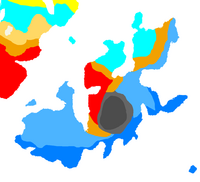
Orioni has a {{wp|tropical marine climate}} that is usually hot and humid. There are three seasons: the hot dry season or summer from March to May; the rainy season from June to November; and the cool dry season from December to February. Temperate easterly winds and southernlyocean currents ensure warm summers and very mild winters. Seasons vary per region, with the south being warmer compared to the rainy west and subtropical north. Temperatures usually range from 21 °C (70 °F) to 32 °C (90 °F) although it can get cooler or hotter depending on the season. The coolest month is January; the warmest is May. | |||
The average yearly temperature is around 26.6 °C (79.9 °F). In considering temperature, location in terms of latitude and longitude is not a significant factor. Whether in the extreme north, south, east, or west of the country, temperatures at sea level are in the same range. Altitude usually has more of an impact. The average annual temperature on the [[#geography|Mendakh mountains]] at an elevation of 1,500 meters (4,900 ft) above sea level is 18.3 °C (64.9 °F), making it a popular destination during hot summers. | |||
=== Fauna and flora === | |||
{{multiple image | |||
| align = left | |||
| total_width = 300 | |||
| image_style = border:none; | |||
| title = | |||
| perrow = 2 | |||
| caption_align = center | |||
| image1 = Amazonas Flussdelfin Apure Orinoco Duisburg 01.jpg | |||
| caption1 = A pair of pink dolphins. | |||
| image2 = Monteverde_puente.jpg | |||
| caption2 = Canopy walkway in the tropical forest of Alnitak. | |||
| image3 = DentelleMontmirail.jpg | |||
| caption3 = Vineyards along the Dayonisesi foothills. | |||
| image4 = La vida tranquila (25922837736).jpg | |||
| caption4 = Lake $name in summer | |||
}} | |||
Fauna in Orioni is quite diverse. The Orinese archipelago has many different animals in all shapes and sizes that are adapted to a wide range of climates and altitudes. About 53% of Orioni is either forested or mountainous. Orioni has a tropical marine climate that is usually hot and humid. The southeastern mountain flanks enjoy a nice climate that allows for vineyards to grow. Lush broadleaved trees in the northern forest. These lush green giants cover most of the country. Some areas are inhospitable to human habitation, such as the coastal deserts of western Alnilam. The main ecological divide is the one between urban pets versus rural “pets”. | |||
Venture outside any city and you'll meet a much wider variety of animals. The [[Pink dolphin]] (''Inia geoffrensis'') is the national animal of Orioni. They are solitary animals and live primarily in the southern river systems of the [[#Geography|Wenizi]] and [[#Geography|Caroni]]. Pink dolphins are unique among dolphins for having molar-like teeth and can chew their prey. The diet of Orioni river dolphins comprises {{wp|fish}}, {{wp|shrimps}} {{wp|crabs}}. They also eat {{wp|piranhas}} and {{wp|turtles}}. Pink dolphins are true carnivores (meat-eaters). Pink dolphins can move from rivers to ponds and lakes during the rainy season (when rivers flood). Some pink dolphins are actually very rare albinos. Albino dolphins can appear pink instead of white because of the blood vessels under their skin. For really wild animals, there's only one place: the northeastern [[Amilaki Wildlife Reserve]], established by EOS. It is the least populous region, with the longest coastline, largest area, lowest annual temperature, coldest winters, highest temperature difference between seasons, and most volcanic activity. Head up to Adansi to see an entirely different side of the country. The city is located in the mountainous Kidusi province. Elephant rides are a popular activity here, although the practice is sometimes ethically questionable. Tourists love visiting the elephant sanctuaries, transplanted from the Kingdom of Koku, which allow visitors to appreciate these magnificent creatures while providing them with a safe and loving environment at the same time. The cultural influence of animals is widely debated and certainly not settled. Some non-native animals were imported from former colonies, while enemies also brought animals to Orioni. For example, royal processions in the 10th Century CE are known to have included elephants. During the [[Orinese Civil War]] (1023-1174) the mercenaries of [[Uthman ibn Naissa]] brought many horses with them, an animal that's not native to tropical Orioni.<ref>[https://www.europans.com/topic/5982-december-2020-event-daily-worldbuilding-prompts/?do=findComment&comment=40015964 Pets in Orioni] (3 December 2020)</ref> | |||
Hunting and fishing is regulated on the provincial level. Historically, tigers were hunted to collect their famous striped skins. Tiger hunting took place on a large scale in the early 19th and 20th centuries. It was an admired sport by the continental Europan aristocrats. Tiger hunting was done on foot with a goat or buffalo as bait. The trade in tiger skins peaked in the 1930s. In some provinces, there is a hunting season for boars and deer, which cause large amounts of agricultural damage, until mid-March. In the mountainous provinces there are special hunting clubs in towns and villages. The men raise dogs to hunt wild boars in the mountains. The men get dressed up and put on their hats, they load up their dogs in trucks, cars, motorbikes and scooters, and they go hunting. Hunters are required to have gun and trapping licences. Boar and deer populations continue to climb despite efforts to shrink their numbers, Orioni is facing an ageing, declining population that increasingly lacks the energy, interest, and funding to cull wildlife.<ref>[https://www.europans.com/topic/5982-december-2020-event-daily-worldbuilding-prompts/?do=findComment&comment=40016029 Hunting and fishing in Orioni] (15 December 2020)</ref> | |||
For the average city dweller without much living space, you have your standard cats and dogs and what have you. School children are allowed to take care of the class aquarium fish. There is also a lively underground network of illegal trade in snakes and other reptiles. | |||
=== Administrative divisions === | |||
{{see also|List of cities in Orioni}} | |||
[[File:Administrative divisions of Orioni.png|200px|thumb|Regions and provinces of Orioni for the 2019 election.]] | |||
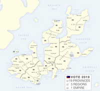
The bureaucratic administration of Orioni is divided into four basic levels. Following the {{wp|Nomenclature of Territorial Units for Statistics}} (NUTS), these levels are: country, region (NUTS-1), province (NUTS-2), and municipality (LAU). Below the national government, there are 5 regions, further divided into 19 provinces. Regions do not have elected officials, nor are they corporate bodies. But the practice of ordering provinces based on their geographic region is traditional. Every province has its head of the executive branch (governor), a legislative parliament, and a constitutional court. The governor is directly elected. Their considerable practical powers are moderated by the legislature. | |||
* '''Weriki''' (central) forms the core of the empire, with its ancient traditions and ageless monuments. It is the geographic location of the first {{wp|tribe}}s that banded together before politically uniting the entire island. Weriki has: the highest annual precipitation, fewest sunshine hours, smallest area, highest energy consumption, largest population, and hottest summers. | |||
* '''Asehayi''' (east) is geographically similar to the central region, but it is less populous because of the more arid climate. The rough inland geography encourages a more seaward attitude. Asehayi has: the most landslides, highest altitude, and wettest winters. | |||
* '''Irisha''' (west) has always followed a more continental approach, influenced by its proximity to the [[Europa (continent)|Europa]]n mainland across the [[#geography|Tethys Sea]]. It is agriculturally important thanks to the fertile land of the Western Plains. Irisha has: the largest forest area, lowest altitude, coolest summers, mildest winters. | |||
* '''Semeni''' (north) is the most mountainous region, dominated by the [[Mendakh Mountains]]. Rich in minerals, its mining enterprises provide most resources for the nation's industrial activity. The many rivers and coastal roads enhance accessibility, supported by a railroad network along the coast. Semeni has: the lowest annual precipitation, most erosion, most mineral resources, most climate diversity, highest annual temperature, most greenhouse farming, driest summers, smallest forest area, and most sunshine hours. | |||
* '''Amilaki''' (northeast) is the least populous region. Most of the area is part of the [[National Parks and Preserves of Eurth|Amilaki Wildlife Reserve]] established by [[EOS]]. Amilaki has: the longest coastline, largest area, lowest annual temperature, coldest winters, the highest temperature difference between seasons, most volcanic activity, and smallest population.{{efn|OOC. For inspiration about Kidusi, look to {{wp|Cadusii}}.}} | |||
From north to south, the provinces of Orioni and their commonly associated regions are: | |||
{{Administrative divisions of Orioni}} | |||
During the 20th century, Orioni claimed numerous neighbouring countries and regions in [[Europa (continent)|Europa]], [[Thalassa]] and [[Marenesia]] were “lost provinces” of Orioni. Many of these “lost provinces” were under the rule of Imperial Orinese dynasties or were former tributary states. Empress [[Hensei Nabérrie]] claimed in August 1997 that these provinces were lost because of unequal treaties, forceful occupation and annexation, and foreign interference.{{efn|OOC. Dated to one month after the {{wp|handover of Hong Kong}} to the PRC. This statement might also explain her premature death in a car crash. To be explored at a later date.}} These former provinces include [[Rohini]], [[Burkini]], the outlying islands of [[Miiros]]. | |||
Revision as of 06:58, 9 December 2024
Introduction
Kingdom Sahra | |
|---|---|
| Motto: One Mountain Cannot Accommodate Two Tigers. | |
| Anthem: [[]] [[]] | |
| Capital |
|
| Largest city | Ha Nihn |
| Official languages | Oharic |
| Recognised regional languages | Meharic; Nyburanic |
| Ethnic groups | Medanese |
| Demonym(s) | Sahran |
| Government | Theocracy |
| Formation | |
• Proto Pharaoh period | 1150 BC |
• Sa ma khom Dynasty | 1100 BC |
• So-Rah Dynasty | 1915 AD |
• Sahradduce Period | 1950 - 2024 AD |
| Area | |
• Total | 1,139,811 km2 (440,083 sq mi) |
• Water (%) | 4.20 |
| Population | |
• 2024 census | 32,800,000 |
| GDP (nominal) | 2024 estimate |
• Per capita | 12,000 |
| Currency | Sahra Scrip (SRS (₴)) |
| Date format | dd/mm/yyyy |
| Driving side | right |
| Internet TLD | .io |
This article is incomplete because it is pending further input from participants, or it is a work-in-progress by one author. Please comment on this article's talk page to share your input, comments and questions. Note: To contribute to this article, you may need to seek help from the author(s) of this page. |
Geography

Orioni is located at the easternmost region of Europa, separated from the Europan mainland by the Tethys Sea and along the Oriental Ocean. At 1,155,853 km2 (446,277 sq mi), according to the AN Geographic Yearbook, Orioni is the 2nd-largest country on Eurth. It is slightly larger than Volsci, twice the size of Tamurin, three times as big as Variota, four times the size of Batengdei and five times the size of the Seylos. The main island, also called the “Home Island", is divided into three parts: western Alnitak where the majority of the Orinese population lives, central Alnilam is dominated by the Mendakh mountains, and northeastern Almintaka forms a sparsely inhabited nature preserve. Besides the main island, there are also 430 smaller islands, of which the larger ones are being inhabited and others remain uninhabited. To the west of Nordhaven lies Deseti island, which hosts the headquarters for the Entente of Oriental States. To the southeast of Oris lies Malindi island which is presently occupied by Miiros.
Mount Silesto in Amilaki at 3,450 m (11,320 ft) is the highest peak in Orioni. Excluding the Rohini and Burkini islands, the country lies between latitudes 15° and 31°N, and longitudes 135° and 152°E. It is south of Ide Jima, separated by the Rosario Sea; and north of Niederoestereich, separated by the Azure Sea. The closest neighbouring country to Orioni is the Tamurin republic westward across the Roavia Strait. Orioni maintains maritime claims on the continental shelf of 200 m depth or to the depth of exploitation. Its territorial sea extends 12 nautical miles (22,2 km or 13,8 mi) with an exclusive economic zone of 200 nautical miles (370 km or 230 mi). The northernmost point is Cape Tawiseni extending into the Rosario Sea, Mar province (30°57'N). The easternmost point is Cape Amrita on the Deli peninsula, Meda province (152°04'E). The southernmost point is an unnamed point in one of the shifting sandbanks of the Wenizi river delta at low tide, Zuidhaven province (15°29'N). The westernmost point is Cape Suzette, Sirius province (134°54'E).
Landscape
About 53% of Orioni is either forested or mountainous, making it largely unsuitable for agricultural, industrial, or residential use. Hill country of over 500 m (1640 ft) above sea-level dominates the Home Island and in some other elevated regions such as central Alnilam even 2000 m (6561 ft). Additional areas are inhospitable to human habitation, such as the coastal deserts of western Alnilam. This means that coastal areas contain habitable zones and have high population densities. The population tends to cluster around fresh-water sources and seaports. As a result, these coastal regions of Orioni are some of the most densely populated areas on Eurth.
The western part of the country contains temperate forestland and rolling hills, with a strong agricultural imprint on the northern plains and along the Firigirigi river. The mountain ranges created great rivers that carry their sediment down to the lowlands, enriching the soil. The Wenizi river flows through the western part of the country, its origin located somewhere in the high mountains towards the east. The artificial Owara canal connects the Wenizi with the Firigirigi, enabling shipping to multiple parts of this western region. The canal was built in 1671 by decree of Empress Owara and modernised in around 1900. Between 1895 and 1904, the army engineers enlarged the Owara canal to 25 metres (82 feet) wide and 3 metres (9.8 feet) deep. Empress $name expanded the canal again to 40 metres (130 feet) wide and 4.5 metres (14.8 feet) deep through mountainous rocky terrain.
In the east and south, along the shores of the Azure Sea, are extensive and densely populated alluvial plains of the Wenizi and the Caroni river, combined with lower mountain ranges in the Zinabi valley to the east. This fertile valley in the southeastern part of the country is curtailed by the Dayonisesi mountains, a mountain range that forms an enclosing arc, and also contains the countries highest point, Mount Silesto at 3,450 m.
The northeastern region of Orioni consists of elevated highlands called the Mendakh mountains by the local mountain tribes.
Climate
Orioni has a tropical marine climate that is usually hot and humid. There are three seasons: the hot dry season or summer from March to May; the rainy season from June to November; and the cool dry season from December to February. Temperate easterly winds and southernlyocean currents ensure warm summers and very mild winters. Seasons vary per region, with the south being warmer compared to the rainy west and subtropical north. Temperatures usually range from 21 °C (70 °F) to 32 °C (90 °F) although it can get cooler or hotter depending on the season. The coolest month is January; the warmest is May.
The average yearly temperature is around 26.6 °C (79.9 °F). In considering temperature, location in terms of latitude and longitude is not a significant factor. Whether in the extreme north, south, east, or west of the country, temperatures at sea level are in the same range. Altitude usually has more of an impact. The average annual temperature on the Mendakh mountains at an elevation of 1,500 meters (4,900 ft) above sea level is 18.3 °C (64.9 °F), making it a popular destination during hot summers.
Fauna and flora
Fauna in Orioni is quite diverse. The Orinese archipelago has many different animals in all shapes and sizes that are adapted to a wide range of climates and altitudes. About 53% of Orioni is either forested or mountainous. Orioni has a tropical marine climate that is usually hot and humid. The southeastern mountain flanks enjoy a nice climate that allows for vineyards to grow. Lush broadleaved trees in the northern forest. These lush green giants cover most of the country. Some areas are inhospitable to human habitation, such as the coastal deserts of western Alnilam. The main ecological divide is the one between urban pets versus rural “pets”.
Venture outside any city and you'll meet a much wider variety of animals. The Pink dolphin (Inia geoffrensis) is the national animal of Orioni. They are solitary animals and live primarily in the southern river systems of the Wenizi and Caroni. Pink dolphins are unique among dolphins for having molar-like teeth and can chew their prey. The diet of Orioni river dolphins comprises fish, shrimps crabs. They also eat piranhas and turtles. Pink dolphins are true carnivores (meat-eaters). Pink dolphins can move from rivers to ponds and lakes during the rainy season (when rivers flood). Some pink dolphins are actually very rare albinos. Albino dolphins can appear pink instead of white because of the blood vessels under their skin. For really wild animals, there's only one place: the northeastern Amilaki Wildlife Reserve, established by EOS. It is the least populous region, with the longest coastline, largest area, lowest annual temperature, coldest winters, highest temperature difference between seasons, and most volcanic activity. Head up to Adansi to see an entirely different side of the country. The city is located in the mountainous Kidusi province. Elephant rides are a popular activity here, although the practice is sometimes ethically questionable. Tourists love visiting the elephant sanctuaries, transplanted from the Kingdom of Koku, which allow visitors to appreciate these magnificent creatures while providing them with a safe and loving environment at the same time. The cultural influence of animals is widely debated and certainly not settled. Some non-native animals were imported from former colonies, while enemies also brought animals to Orioni. For example, royal processions in the 10th Century CE are known to have included elephants. During the Orinese Civil War (1023-1174) the mercenaries of Uthman ibn Naissa brought many horses with them, an animal that's not native to tropical Orioni.[1]
Hunting and fishing is regulated on the provincial level. Historically, tigers were hunted to collect their famous striped skins. Tiger hunting took place on a large scale in the early 19th and 20th centuries. It was an admired sport by the continental Europan aristocrats. Tiger hunting was done on foot with a goat or buffalo as bait. The trade in tiger skins peaked in the 1930s. In some provinces, there is a hunting season for boars and deer, which cause large amounts of agricultural damage, until mid-March. In the mountainous provinces there are special hunting clubs in towns and villages. The men raise dogs to hunt wild boars in the mountains. The men get dressed up and put on their hats, they load up their dogs in trucks, cars, motorbikes and scooters, and they go hunting. Hunters are required to have gun and trapping licences. Boar and deer populations continue to climb despite efforts to shrink their numbers, Orioni is facing an ageing, declining population that increasingly lacks the energy, interest, and funding to cull wildlife.[2]
For the average city dweller without much living space, you have your standard cats and dogs and what have you. School children are allowed to take care of the class aquarium fish. There is also a lively underground network of illegal trade in snakes and other reptiles.
Administrative divisions
The bureaucratic administration of Orioni is divided into four basic levels. Following the Nomenclature of Territorial Units for Statistics (NUTS), these levels are: country, region (NUTS-1), province (NUTS-2), and municipality (LAU). Below the national government, there are 5 regions, further divided into 19 provinces. Regions do not have elected officials, nor are they corporate bodies. But the practice of ordering provinces based on their geographic region is traditional. Every province has its head of the executive branch (governor), a legislative parliament, and a constitutional court. The governor is directly elected. Their considerable practical powers are moderated by the legislature.
- Weriki (central) forms the core of the empire, with its ancient traditions and ageless monuments. It is the geographic location of the first tribes that banded together before politically uniting the entire island. Weriki has: the highest annual precipitation, fewest sunshine hours, smallest area, highest energy consumption, largest population, and hottest summers.
- Asehayi (east) is geographically similar to the central region, but it is less populous because of the more arid climate. The rough inland geography encourages a more seaward attitude. Asehayi has: the most landslides, highest altitude, and wettest winters.
- Irisha (west) has always followed a more continental approach, influenced by its proximity to the Europan mainland across the Tethys Sea. It is agriculturally important thanks to the fertile land of the Western Plains. Irisha has: the largest forest area, lowest altitude, coolest summers, mildest winters.
- Semeni (north) is the most mountainous region, dominated by the Mendakh Mountains. Rich in minerals, its mining enterprises provide most resources for the nation's industrial activity. The many rivers and coastal roads enhance accessibility, supported by a railroad network along the coast. Semeni has: the lowest annual precipitation, most erosion, most mineral resources, most climate diversity, highest annual temperature, most greenhouse farming, driest summers, smallest forest area, and most sunshine hours.
- Amilaki (northeast) is the least populous region. Most of the area is part of the Amilaki Wildlife Reserve established by EOS. Amilaki has: the longest coastline, largest area, lowest annual temperature, coldest winters, the highest temperature difference between seasons, most volcanic activity, and smallest population.[a]
From north to south, the provinces of Orioni and their commonly associated regions are:
| █♦█ Amilaki region | █♦█ Semeni region | █♦█ Irisha region | █♦█ Asehayi region | █♦█ Weriki region |
|---|---|---|---|---|
During the 20th century, Orioni claimed numerous neighbouring countries and regions in Europa, Thalassa and Marenesia were “lost provinces” of Orioni. Many of these “lost provinces” were under the rule of Imperial Orinese dynasties or were former tributary states. Empress Hensei Nabérrie claimed in August 1997 that these provinces were lost because of unequal treaties, forceful occupation and annexation, and foreign interference.[b] These former provinces include Rohini, Burkini, the outlying islands of Miiros.
- ↑ Pets in Orioni (3 December 2020)
- ↑ Hunting and fishing in Orioni (15 December 2020)
Cite error: <ref> tags exist for a group named "lower-alpha", but no corresponding <references group="lower-alpha"/> tag was found
