Namija: Difference between revisions
m (1 revision imported) |
mNo edit summary |
||
| Line 19: | Line 19: | ||
| map_alt = | | map_alt = | ||
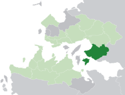
| map_caption = '''Namija''' (dark green) in the [[Trellin|Kingdom of Trellin]] (light green) | | map_caption = '''Namija''' (dark green) in the [[Trellin|Kingdom of Trellin]] (light green) | ||
| coor_pinpoint = | | coor_pinpoint = | ||
| coordinates_type = | | coordinates_type = | ||
| Line 95: | Line 89: | ||
| postal_code_type = | | postal_code_type = | ||
| postal_code = | | postal_code = | ||
| area_code_type = | | area_code_type = [[Telephone numbers in Trellin|Area code(s)]] | ||
| area_code = | | area_code = 056, 057, 058 | ||
| iso_code = | | iso_code = | ||
| website = <!-- {{URL|example.com}} --> | | website = <!-- {{URL|example.com}} --> | ||
Latest revision as of 14:48, 9 April 2019
Namija | |
|---|---|
 Namija (dark green) in the Kingdom of Trellin (light green) | |
| Nation | Trellin |
| Capital | Cavari |
| Government | |
| • Princess | Satiana Palægos |
| Population (2013) | |
| • Total | 18,419,276 |
| Demonym | Namijan |
| Area code(s) | 056, 057, 058 |
Namija (pronounced /næˈmiːdʒɑː/), officially the Principality of Namija (Trellinese: Lametha Namijika), is a province of the Trellinese Empire. At 145,994 km² it is the second largest province in the empire, behind only Khatax.
Namija is bordered to the north by the province of Ja'ekha and to the east by the Dangish Empire, and faces the Sea of Velar to the south and west. The southern coast holds the Trophy Port enclave of Mintra. It is the empire's 2nd-most populous province after Arimathea and the most populous in the Kingdom of Trellin with 18,419,276 people. Namija's capital is the city of Cavari, which lies at the top of the Hanoth delta.
History
Namija, like much of northern Trellin, has been inhabited by indigenous tribes for thousands of years. The oldest known archaeological sites, however, only date from 800 BC, ruins of the Velaric civilisation near the southern coast. While southern Namija remained mainly Velaric, with occasional Perendi settlements, the northwest coast was colonised by Ethlorek settlers in the early second century BC and, later, by Trellinese settlers. In 644 AD the already autonomous Trellinese inhabitants declared independence under their own prince.
In the middle ages, the Namijan princes waged war against their eastern and southern neighbours, or married their way to their thrones. They maintained a long peace with their northern neighbours in Ja'ekha and subsequently remained relatively neutral in regional politics. The port of Mintra was established by Trellinese merchants in the late 12th century on the southern coast.
The principality entered the Trellinese Empire in 1835 after Princess Lusilia married Txerig III. Namija was one of the main theatres of conflict during the Trophy Wars, when it was invaded by Andamonian forces. These invaders were repulsed in early 1934 when attempting to cross the Hanoth.
Geography

Namija has a total landmass of 145,993.84 km². The majority of this is on the mainland, though roughly a tenth of the province's area is the island of Kerypa, to the south. Hills form most of Namija's borders with Ja'ekha and Dungeyland; the westernmost of the river Trelk's numerous distributaries forms the remainder.
Despite its large population and a growing wood export industry, much of Namija remains heavily forested. The regular and often extreme flooding of the Hanoth river has restricted development along most of its course, supplemented in recent decades by the designation of the middle Hanoth and its surroundings as an area of special conservation. The province's terrain is relatively flat, rising only to low hills along its eastern borders with Dungeyland and Ja'ekha. Between these uplands and the low, coastal plateaux in the west is a broad plain through which the Hanoth flows with numerous broad meanders. A substantial portion of the river's course is defined by the Qeqsaraken, a vast wetland region, and the shallow Lake Revuniq. The river's biannual flooding in its middle and lower course leaves substantial amounts of fertile alluvium.

