Wazheganon
This article is incomplete because it is pending further input from participants, or it is a work-in-progress by one author. Please comment on this article's talk page to share your input, comments and questions. Note: To contribute to this article, you may need to seek help from the author(s) of this page. |
Free Federated Nations of Wazheganon 8 official names a
| |||||||||||||||||||||
|---|---|---|---|---|---|---|---|---|---|---|---|---|---|---|---|---|---|---|---|---|---|
Flag
Coat of Arms
| |||||||||||||||||||||
Motto: «ᐊᓇᒻᔅᑦᕋᑦᕝᓓᕐ, ᐗᐸᒣ᙮» "Anamstratfler, wapame." "Beneath the pavement, the beach." | |||||||||||||||||||||
Anthem: ᐊᐌᐤ ᑎᔅ ᓚᓐᑌ ᒍᐦ ᓚᓐᑌ Aweu Dis Land Jou Land "This Land Is Your Land" | |||||||||||||||||||||
 Location of Wazheganon on Earth, with claimed territory in light green. | |||||||||||||||||||||
 Political Map of Wazheganon | |||||||||||||||||||||
| Capital | Moynrout | ||||||||||||||||||||
| Largest city | Jabwegan | ||||||||||||||||||||
| Official languages | none at the federal level [a] | ||||||||||||||||||||
| Recognised national languages | [b] | ||||||||||||||||||||
| Recognised regional languages | |||||||||||||||||||||
| Ethnic groups (2020) | List of ethnicities
| ||||||||||||||||||||
| Religion | List of religions
| ||||||||||||||||||||
| Demonym(s) | Wazhenaby Wazhenabyg (plural) Wazhe(g) (colloquial) | ||||||||||||||||||||
| Government | Libertarian socialist federated semi-direct democracy | ||||||||||||||||||||
• Chancellor | Dyodosha Wolf | ||||||||||||||||||||
• Speaker | Minegan Kovaric | ||||||||||||||||||||
| Legislature | Federal Congress | ||||||||||||||||||||
| General Committee | |||||||||||||||||||||
| Federal Congress | |||||||||||||||||||||
| Independence from Tyrrslynd | |||||||||||||||||||||
| July 8th, 1731 | |||||||||||||||||||||
| July 8th, 1921 | |||||||||||||||||||||
| September 21st, 1957 | |||||||||||||||||||||
| November 1st, 1976 | |||||||||||||||||||||
| Area | |||||||||||||||||||||
• Total area | 1,854,816 km2 (716,148 sq mi) | ||||||||||||||||||||
• Water (%) | 14 | ||||||||||||||||||||
| Population | |||||||||||||||||||||
• 2020 census | 47,703,216 | ||||||||||||||||||||
• Density | 25.71/km2 (66.6/sq mi) | ||||||||||||||||||||
| GDP (nominal) | 2020 estimate | ||||||||||||||||||||
• Total | $1,327,580,501,280 | ||||||||||||||||||||
• Per capita | $27,830 | ||||||||||||||||||||
| Gini (2015) | low | ||||||||||||||||||||
| HDI (2015) | very high | ||||||||||||||||||||
| Currency | Wazhenaby kroun (ᑲᕑ) (WZK) | ||||||||||||||||||||
| Time zone | UTC -4 to -5 | ||||||||||||||||||||
| Date format | dd/mm/yyyy | ||||||||||||||||||||
| Driving side | right | ||||||||||||||||||||
| Calling code | +64 | ||||||||||||||||||||
| Internet TLD | .wz | ||||||||||||||||||||
Wazheganon (/wɑːˈʒɛɡənɔːn/ wah-ZHAY-guh-nun, -ZHEH-,-NAWN), officially the Free Federated Nations of Wazheganon, sometimes colloquially referred to as the Wazhenaby Federation or Wazhenaby Union, is a country in northeastern Norumbia. Its 15 commonwealths cover a peninsula of approximately 1,854,816 square kilometers (716,148 square miles), situated between the Sea of Dakmoor, across from Ghant, in the north and northeast, the Salacian Ocean in the southeast, and Winivere Bay in the west, sharing land and maritime borders with Awasin in the southwest and Moxaney in the southeast. Most of Wazheganon's population of 47,703,216 people live in the watershed surrounding the Kaċecameg lake system and the river Mazhesepeu. The capital of Wazheganon is Moynrout, while its largest city is Jabwegan. Other major cities include Victorya, Menawa, and Zorai. Wazheganon is a highly multicultural country, with the majority of the population identifying as Mezhte, a creole group drawing from indigenous, Belisarian, Oxidentalese, and Ochranese heritages.
Various indigenous peoples have inhabited what is now Wazheganon since the last ice age. The earliest written records from Wazheganon are found on birchbark scrolls dating back to the 12th century. Historically, the dominant political model was that of the mawaċimauweg, in which kinship groups formed loose confederations based on cultural ties. While contact with Belisarians was made as early as the 12th century, incursions into modern Wazheganon were largely repelled until the Great Lake War in the late 16th century, when Ottonian Tyrrslyndic colonizers advanced on weakened and disorganized coastal confederacies, forcibly displacing local populations and repopulating newly conquered land with Kamryker settlers from Onneria. Several of these Tyrrslyndic gained independence in 1733 as Valzia, and expanded into the continental interior in a series of protracted and deadly wars with indigenous polities, culminating in the Asherionic Wars.
The Waltzing Coups period dominated Wazhenaby politics for much of the 19th century, causing significant political turmoil and popular unrest. Beginning in the 1880s, the country saw a series of socialist reforms and uprisings which eventually culminated in the Wazhenaby Civil War from 1919 to 1921. Afterwards, the new Wazhenaby Federal Socialist Republic experienced several smaller ideological upsets before finally galvanizing into the contemporary political structure in 1957. Significant reforms in pursuit of decolonization took place in the 1970s and 1980s.
Wazheganon is a libertarian socialist federation in the communalist tradition, consisting of 1,732 autonomous communes and 14 nominally independent commonwealths, with a unicameral legislature which elects a steering committee to carry out executive functions, in a system of council democracy. It maintains a decentralized hybrid-socialist ecomomy in which basic needs have been decommodified and most businesses are either worker-owned or state-operated. Major industries and products include foodstuffs, forest products, commercial vehicles, industrial machinery, telecommunications, and tourism. Wazheganon ranks highly in international measurements of political freedoms, government transparancy, education, and quality of life. It is a member of several international organizations and alliances, including the Forum of Nations, Joint Space Agency, Kiso Pact, Global Observatory of Labor, Common Congress of Oxidentale and Norumbia, and Osawanon Community.
Etymology
The origins of the name Wazheganon are obscure and debated in academia. It first appears in written records in the late 17th century, as Mashagagon, used by Umbier traders as an apparent indigenous name for the region between the River Mazhesepeu and Lake Ataluca. Despite superficial similarities, it is believed to be unrelated to the modern word Matagamon, which is considered by lingusits to have derived from a Wobenaq word meaning "far on the other side".
Older belocentric folk etymologies held that the name was related to the name of explorer Dietrich Valza, for whom the historical region of Valzia is named, but this has been rejected by scholars since the late 19th century.
The most likely origin with widespread scholarly support today is that the word derives from a clipped compound of the words Mazhe (a form of Mezhte) and jiigi-zaaga'igan, an Onigamymowin word meaning "by the lake shore". Thus, the name would roughly translate to "the Mixed by the lake". This would make sense, as in the 1600s the area around northern Lake Ataluca was an entrepot of trade which would have featured significant populations of early mixed Belisarian-Indigenous people; it is possible that this name was used by Onigamyg to refer to the locals, and misinterpreted by Umbier colonists as the name for the region.
It is unclear precisely when or where the switch from "mash" to "wazh" occurred, but, by the 1730s, the spelling Wauzhegigan was common, anglicized as Wazheganon, and the word was used to refer to the general borderlands region in what is now east-central Wazheganon. It was adopted as the name for the country with the establishment of the Federal Wazhenaby Socialist Republic in 1921.
Demonyms
Numerous demonyms and nicknames are used officially and colloquially to refer to people from Wazheganon and various groups therein. The official noun and adjective for an individual from Wazheganon is Wazhenaby (plural: -g). '"Wazhe/y (plural: -g) is acceptable shorthand for Wazhenaby.
A majority of Wazhenaby identify as Mezhteg, derived from the Umbiaans word Mëschtes, meaning "mixed". Although they may consider themselves part of this larger creole group, it is also common for individuals to simultaneously identify with various Belisarian or indigenous groups based on their ancestry.
Wazhenaby descended from Belisarians ("Belo-Wazhe"), primarily Umbiers (of primarily Ottonian but also general Belisarian descent) but also Gexabans (of Ghantish descent), are often called mooks (from Onigamymowin: gichi-mookomaan, literally "long knife") by indigenous peoples, while indigenous peoples are frequently nicknamed bylies (from Umbiaans: byl, literally "ax") by Belo-Wazhe. These terms occasionally carry negative connotations, but are also frequently used affectionately or neutrally in recent decades and so depend mostly on context.
Indigenous Wazhenabyg as a whole can be referred to as First Nations (Ashinatig), Indigenous Wazhenabyg (Inhëmwazhenabyg), or Nebeseuweg (derived from an old term meaning "lake people").
The term Josy/ee (from the 17th century Nordic pejorative Jo Sild, meaning Johannes Herring) is used as a catch-all nickname for anybody from the east coast or eastern third of the country, regardless of descent, and is sometimes applied more liberally to somebody from any part of the country by foreigners.
Official title
Officially, the country is known to as the Free Federated Nations of Wazheganon (Wazhewen: Wrymawaċimaubond Wauzhagigan, ᐤᕐᔾᒪᐗᒋᒪᐤᐳᓐᑌ ᐗᐤᔕᑭᑲᐊᓐ). Colloquially however, as well as in some official settings, the country is referred to be many other titles, including, the Federation, the Union, and the United Nations. Another moniker is that of "the Republic", or "the Fourth Republic", which are usually considered poor taste, as they associate the current Wazhenaby state with that of previous failed governments with wildly differing ideologies.
Geography and climate
Wazheganon comprises the northeastern corner of Norumbia, occupying approximately 1,854,816 square kilometers (716,148 square miles) lying approximately between the latitudes 48° and 72°N and longitudes 76° and 103°W. Despite its position and cool climate, no part of mainland Wazheganon lies above the Boreic Circle; the only part of Wazheganon to extend so far north are the islands of Wanleussenland and Nijau Kisinatin in Misiqwan. Wazheganon is situated on the northern end of Norumbia's northeastern peninsula, surrounded by Winivere Bay to the west, the Sea of Dakmoor across from Ghant to the north, and the Salacian Ocean in the east. It shares land and maritime borders with Awasin in the southwest and Moxaney in the southeast.
The geography of Wazheganon is dominated by a series of freshwater lakes and rivers called the Kaċecameg (ᑲᒉᒐᒣᑫ), literally meaning the Great Lakes, which connect to the Sea of Dakmoor via the River Mazhesepeu. They consist of, in order of largest to smallest: Kaċecam (ᑲᒉᒐᒻ) [d], Ginögama (ᑭᓄᐅᑲᒪ), and Ataluca (ᐊᑕᓗᐅᒐ); the southern bay of Kaċecam is called Hoshicyra (ᐦᐅᔑᒐᔾᕋ) and often treated as a separate lake, despite not being an independent body of water. Ontaraqy ᐅᓐᑕᕋᑫᐁ), part of the Mazhesepeu, is also usually included among the Kaċecameg. Kaċecam is the second largest lake in Norumbia, with a surface area of approximately 64,352 square kilometers (24,846 square miles), and one of the deepest lakes in the world with a maximum depth of 706 meters (2,316 feet). The collective watershed of the Kaċecameg encompasses the majority of mainland Wazheganon, with thousands of rivers flowing into the lakes. The longest of these is the Mineshösh River, which flows over 1,133 kilometers (704 miles) from norther Misiqwan to Hoshicyra. The Kaċecameg flow out into Chigïgö Bay, the largest estuary in the world, from the Mazhesepeu and Lake Ontaraqy. Not including Lake Ontaraqy, Mazhespeu is one of the widest rivers in the world, standing 40 kilometers (25 miles) at its widest point. Not including the estuary, the Mazhesepeu is approximately 252 kilometers (157 miles) long.
Regions of Wazheganon that are not part of the Kaċecameg basin are typically separated from it by hills and mountains. The eastern coast is primarily flat and rocky, characterized by many inlets and islands, most notably Hesepuq Bay. The Oscandowa Mountains run along the east coast from Sangweny in the north to Oscandowa in the south. They transition into the larger and more rugged Osawanon Mountains along the Oscandowa-Jenasy border. The Osawanons begin in northern Matagamon and go both south into Moxaney and west along the southern border. The Gerögera Mountains run along the west coast from northern Misiqwan into Awasin, forming the easternmost segement of the Winivere Cordillera. The highest mountain in the Gerögeras, Dolidaq, is also the highest peak in Wazheganon at 5959 meters.
Climate

Wazheganon is dominated by a humid continental climate, of the hot-summer variety on the east coast and the warm-summer variety in the interior. Cold air from the Boreic and warm air from the Kayamuca stream produce dynamic, frequently extreme weather patterns. The Kaċecameg produce a strong moderating effect for much of the region, but heavy and frequent lake-effect snow is common in the winters, where snow can remain on the ground for as long as six months. Summers are typically warm and mild, although heatwaves are not uncommon. The region around the Kaċecameg hosts fertile farmland and extensive forests, ranging from the Lotharian forests on the east coast, to the Kaċecameg Northwoods in the interior, to extensive boreal forest in the north.
Wazheganon's northern regions have a subboreal climate which transitions to a tundra zone along the northern coast and Boreic islands. Along with boreal forests, cold wetlands, extensive lakes, and rolling hills dot the landscape. Some of Wazheganon's most iconic fauna, such as the pygmy forest mastodon and greater hodag, are found in the north.
The west coast of the country is part of the Winivere Cordillera, a sweeping, interconnected series of mountain ranges that spans almost the entirety of the coastline of Winivere Bay throughout Norumbia. In Wazheganon, this region features a subpolar oceanic climate along the coast, with subboreal conditions found in the Gerögera Mountains.

The highest mountain in the Gerögeras, Dolidaq, is also the highest peak in Wazheganon at 5959 meters.

The lakeshore of the Kaċecameg is a popular domestic and international tourist destination and an important economic hub.
- Pygmy forest mastodon.png
The pygmy forest mastodon, once critically endangered, has recovered in the past century and is an iconic mascot of northern Wazheganon.

Cranes taking flight in a marsh in southern Wescouseq.

Urban forests and greenways are common in Wazhenaby cities.

.jpg)


History
Indigenous civilizations
Ottonian colonization
Federal Republic of Valzia
Wazhenaby Federal Socialist Republic
Anouwälist renewal to present
Government and politics

Chancellor

Speaker

Wazheganon is a federal, libertarian socialist council republic in the communalist tradition. Despite a turbulent history, democratic norms are strong in Wazhenaby politics, with human dignity, social consciousness, and individual autonomy enshrined in the constitution. Although the federal constitution makes certain provisions and mandates various rights, each constituency at every level is considered theoretically and nominally independent and sovereign; this means that, so long as the core concepts of the Wazhenaby system (consensus, free association, and militant democracy) are not violated, there is a wide variety of political and economic organization possible witin Wazheganon, ranging from traditional indigenous hereditary councils to syndicalist workplace-conglomerates.
Federal executive and legislative powers are combined together and vested in the Federal Congress, a unicameral body under a delegate model of representation. Congress vests executive power in a General Committee, empowered to act on Congress's behalf in coordinating government departments (called Federal Public Services (FEDeg), as well as making decisions when Congress is not in session or during emergencies where time is of the essence. Members of Congress (LwK(eg)) are elected by grawing directories every two years, although the specific electoral systems which build to the grawing level vary considerably. Presently, Congress consists of 500 members (each representing approximately 100,000 constituents each). Congress is presided over by the Speaker, who oversees debates and votes and is elected by the other members. The speaker also serves on the General Committee as a liaison and watchdog for the rest of Congress. Due to its bottom-up formation, Wazheganon is prone to what has been termed the "house of cards effect", in which a particularly controversial decision by Congress can lead to the instantaneous recalling of dozens or hundreds of representatives at all levels, effectively collapsing the government and spontaneously forcing a new round of elections at any time.
The secretary-general of the General Committee, appointed by Congress, is considered the de facto Chancellor of Wazheganon and the highest-ranking Wazhenaby official. They preside over Committee meetings and serve as the head of state in conducting official visits abroad, as well as usually serving as a public figurehead for the platform of the governing coalition. They also have the possibility of assuming emergency powers to make decisions for the Committee as a whole in instances where the Committee is dispersed or quick reactions are vital. Apart from these roles, the chancellor is a first among equals, having no power above and beyond the other members, and also serves as a regular commissioner of a Federal Public Service. The General Committee typically consists of 17 members, those being the 15 commissioners of the Federal Public Services and the Speaker of the Congress, with the possibility of other members being appointed by Congress as needed. The Committee is appointed by Congress every two years following elections, and the Chancellor is appointed at the beginning of every year, with a term limit of five years. Committee members in general are limited to ten years. All Members of Congress have a term limit of 20 non-consecutive years, meaning that only half of a representatives time in Congress could conceivably be spent on the Committee, and of that time over half of it could be spent as chancellor.
Political parties in Wazheganon function as caucuses (breukeg, literally "fractions") in which numerous regional parties form overarching conventions at a federal level. For example, the Federation of Left-Socialists is comprised of nine smaller groups, each of which is in turn an alliance of various regional and local political organizations. Congressional parties are therefore mostly a convenient estimate of the current political climate, rather than concrete institutions. Due to their imperative mandate, Members of Congress are not obligated to vote along party lines, and can be instantly recalled by their grawing directories if they attempt to vote out of line with their constituents' wishes. Thus, while voting along party lines is common simply due to the similar agendas that formed them, it is also possible for portions of caucuses to individually work with groups from other caucuses. An example of this is the current "War Kettle" coalition, formed from an alliance of individual members from most of the major parties, united by a common desire for military intervention in the Enyaman Civil War.

Western Moynrout is dominated by the Commonwealth Commons, a district of government buildings, cultural centers, and public spaces.

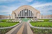
The Donehogawa Building in Moienrout is the official office and part-time residence of the General Committee.
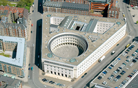
The Commonwealth Building is the meeting place of the Federal Congress.
The Woss Center, colloquially called "the Trapezoid" (Trapezyem) is the headquarters of the Federal Public Defense Service.
.jpg)
.jpg)


Law
Foreign relations
the Northern Common Development Agreement and Antipodal Military Design Bureau
.jpg)
Military
particularly the Center for Permanent Revolution (SJPR, ZEPHYR; Sentrum Jouperminentrewolutie
Constituencies
The most fundamental political subdivision in Wazheganon is the ward, a conglomeration of households, apartment complexes, workplaces, dormitories, and in some cases even military barracks, typically numbering around 100 people, or covering 1-4 city blocks.Template:Enf These wards handle the most basic responsibilities of governance, such as ensuring individuals' needs are being met. As the foundation of a council republic, wards then form neighborhoods, typically containing 200-2000 people, which then confederate into quarters (or parishes, in rural communities), which then form boroughs, a catch-all term referring to various rural and urban population centers which consider themselves one corporate unit; depending on the population density of the region, these might encompass cities or entire rural regions. Neighborhood councils elect delegates to serve on a borough council, which in turn facilitates the confederation of buroughs into communes. Communes, of which there are 1,732, are widely considered the most ubiquitous and relevant level of government, far-reaching enough to allow multiple boroughs to pool significant resources and interact with higher levels, but localized enough to allow for swift communication between citizens and delegates as well as direct involvement by citizens in legislation and implementation of policy. Communes then confederate into counties, which are expected to encompass a population of roughly 100,000 people (and htus tend to shift borders after the census every decade), with some special exceptions made for extremely rural regions, and are the only level whose councils elect delegates to two other levels: both the Federal Congress and the commonwealth level. Commonwealths, of which there are 14, represent the highest level subdivisions, which interface with the federal government and each other on behalf of their constituencies.
Economy
Agriculture
Energy
Tourism
Transporation
Science and technology
Culture
Architecture
Cuisine
Wazhenaby cuisine embodies the inherited tastes and aspects received throughout the nation’s history of Belisarian immigration as they are adapted to a rich, native cuisine, whose domestication of bovidae and early access to dairy coincided with the prolific use of cornmeal. Fluctuating between points of full autonomy and international influence, Wazheganon’s culinary atmosphere emphasizes a savory profile that delves into earthy accents and highlighted sweetness, with a variety of nuts and berries often being used as accentuating enhancers over the core of dishes in contemporary cuisine. Wazhenaby culinary patterns share many similarities to those found in Awasin and Moxaney, to where many restaurateurs and culinarians infer to the styles of cooking and recipes as "Osawanon cuisine", noting that whilst clear deviations appear between each nation based on how cooking changed in their environments, base similarities are entrenched in a common historical culinary landscape.
Staples often reflect notes of Tyrrsylndic and Ghantish presence and impact, but endemic boreic fish, temperate vegetables, and several key herbs are reflective of Wazhenaby cuisine, most notably utilized in their compound butters, accentuating herbs such as fennel, yarrow, sage, and nettle. In savory dishes, aromatic herbs are often smoked and utilized akin to charcoal in order to imbue flavors into many proteins or baked goods, with cheese-baked pastries unique to the northeastern Norumbian corridor often being internationally coveted; examples include Natalanuq, a cheese and onion bread that’s stuffed with sage butter, and Mesemenapwan, a Cornbread that uses dried apples and cherries. Vegetables are primarily root vegetables, and as such, are starchier and commonly assist in making the many heavy stews that have spawned regional variations throughout the nation, with eastern territories often incorporating flavors from Oxidentale as well, with chilis and citrus being unique, and contemporary additions. One reflection of this is in the popular Nystol Chili, which was first created in Nystolmarqsted after the smokey meat of the ‘Muskusrund’ was stewed with beans and dried chilis garnered through the Kayamucan trade routes. In terms of grains, both corn and wild rice were crucial, harvested in several areas and utilized in stews, desserts, and as an additive for stuffing, such as in smaller poultry and game. Agunömin, a fried rice from the Winivere Bay, uses the wild rice with squash and nettle butter, and is often served at celebrations as it is a rich and heavy dish.
Most impressive is the expansive dessert culture and ‘raw’ culinary experience within the area, with the many berries and winter fruits (such as apples and cranberries) from the temperate forests and plains forming many hybrid blends for the many jams and preserves that are served with simple platters, or with the cornbread that is commonplace throughout any area in the region. Syrups derived from these berries were often complemented with maple syrup, making a popular additive not only in deserts, but also in cooking meats, such as the many bacon types that are cured, like Muskox, Duck, and Elk. The Nyniwa sandwich is a staple for many in larger, urban centers, with maple-infused bacon being served with butterhead lettuce and tomato between cornbread slices. In addition, Wazhenaby cheeses are some of the most diverse in their taste profiles and preparation methods given the multiple, deviant sources they come from. With different cheeses of all types, from various blue, soft, semi-firm, and crusted regional variations, high culture and important events can often be embodied by expensive cheese platters to accompany finer culinary aspects, such as Winivere caviar and wild mushroom tarts.
Cuisine is typically divided into one or two general groups; divided into those that seem to derive further from coastal Winivere Bay groups, and those in the Dakmoor sea. Whilst this distinction is most obviously perceived in the sea food utilized, it also takes a further emphasis in the cooking methods often used; with the western coast often developing shorter cooking times and more immediate results, and the eastern coast using longer cooking methods in stews and preserves. Owomewo sticks out as a fish dish from the Western coasts, being baked in maple, and served with wild onion-turnip jam, and served at many fancier settings.
Forms of address
Sports
Symbols
- ↑ Although Wazheganon does not have an official language at a federal level, Wazhewen is spoken as a first or second language by the vast majority of the population and is typically the primary language used in federal proceedings.
- ↑ All commonwealths have one or more official languages. Wazhewen is an official language in all commonwealths except for Nyonerya, Mägdeland, and Santa Elixabete. Gexabarag is an official language in Santa Elixabete and Ternua. Hązírat'e holds official status in Waushyra and Mousinë. Jajigaq'mawi is an official language in Sangweny and Ternua. Masenomaweq is an official language in Meshgoseq, Matagamon, and Jenasha. Nawymawin is official in Misiqwan. Odoleqeneha is official in Jenasha and Taigon. Onigamymowin holds official status in Zagäqwä, Taigon, Misiqan, and Mousinë. Umbiaans is an official language in Nyonerya, Oscandowa, Mägdeland, and Sangweny. Wasooqwit is official in Hyċeqoy.
- ↑ The division between Mezthe and their origin groups is sometimes unclear, with many Mezhteg identifying simultaneously as mixed, indigenous, and/or Belisarian, or as one over the others. Thus, ethnic estimates can vary wildly. "Belo-Wazhe" incorporates all Wazhenabyg of Belisarian descent, but primarily indicates Ottonian or Ghantish origins.
- ↑ Because of its meaning ("Great Lake") the name Kaċecam is usually used on its own, i.e. not "Lake Kaċecam". A similar practice is used for other bodies of water in Wazheganon, such as Ginögama (another lake) and Mazhesepeu (a river).