Aurean Straits: Difference between revisions
No edit summary |
No edit summary |
||
| (2 intermediate revisions by the same user not shown) | |||
| Line 14: | Line 14: | ||
| location = [[Solarian Sea]]—[[Gulf of Assonaire]] | | location = [[Solarian Sea]]—[[Gulf of Assonaire]] | ||
| group = | | group = | ||
| coordinates = | | coordinates = 39°47′N 83°30′W (Western strait)<br/>39°44′N 82°54′W (Eastern strait) | ||
| type = {{wp|Strait}} | | type = {{wp|Strait}} | ||
| etymology = | | etymology = | ||
| Line 24: | Line 24: | ||
| length = <!-- {{convert|VALUE|UNITS}} must be used --> | | length = <!-- {{convert|VALUE|UNITS}} must be used --> | ||
| width = | | width = | ||
| min_width = {{convert|5.4|km|sp=us}} ( | | min_width = {{convert|5.4|km|sp=us}} (Western strait)<br>{{convert|8.7|km|sp=us}} (Eastern strait) | ||
| area = <!-- {{convert|VALUE|UNITS}} must be used --> | | area = <!-- {{convert|VALUE|UNITS}} must be used --> | ||
| depth = {{convert|38|m|sp=us}} | | depth = {{convert|38|m|sp=us}} | ||
| Line 53: | Line 53: | ||
Hydrographically, the [[Community of Nations]] Commission for Maritime Boundaries defines the Straits as follows: | Hydrographically, the [[Community of Nations]] Commission for Maritime Boundaries defines the Straits as follows: | ||
:The two bodies of water connecting the Solarian Sea to the south with the Gulf of Assonaire to the north; the extent of the | :The two bodies of water connecting the Solarian Sea to the south with the Gulf of Assonaire to the north; the extent of the Western strait being between one line connecting the southwestern extremity of the main island of Montecara and the southeastern extremity of Cabo Continental of Paretia and another line connecting the northwestern extremity of the main island of Montecara and the northeastern extremity of Cape XX of Paretia; the extent of the Eastern strait being between one line connecting Pònto da Galàna and Point XX and another line connecting Cape Gansìn and Point XX. | ||
== Ship traffic == | == Ship traffic == | ||
| Line 59: | Line 59: | ||
== Crossings == | == Crossings == | ||
The [[Aurean Tunnel]] | The [[Aurean Tunnel]], which runs under the Western strait, connects Montecara to the Euclean mainland by rail. | ||
A gas pipeline runs from Tsabara underneath Montecara to Euclea. | A gas pipeline runs from Tsabara underneath Montecara to Euclea. | ||
Latest revision as of 17:59, 30 May 2023
| Aurean Straits | |
|---|---|
 | |
| Location | Solarian Sea—Gulf of Assonaire |
| Coordinates | 39°47′N 83°30′W (Western strait) 39°44′N 82°54′W (Eastern strait) |
| Type | Strait |
| Managing agency | Aurean Forum |
| Min. width | 5.4 kilometers (3.4 mi) (Western strait) 8.7 kilometers (5.4 mi) (Eastern strait) |
| Average depth | 38 meters (125 ft) |
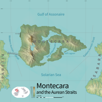
The Aurean Straits are a pair of narrow natural channels at the narrowest point between the continents of Euclea and Coius. They lie to either side of the island city-state of Montecara and border Paretia on the Euclean side and Tsabara on the Coian side. The Straits lie in the three countries’ territorial waters but are open to all traffic under the principle of transit passage.
Definition and extent
Hydrographically, the Community of Nations Commission for Maritime Boundaries defines the Straits as follows:
- The two bodies of water connecting the Solarian Sea to the south with the Gulf of Assonaire to the north; the extent of the Western strait being between one line connecting the southwestern extremity of the main island of Montecara and the southeastern extremity of Cabo Continental of Paretia and another line connecting the northwestern extremity of the main island of Montecara and the northeastern extremity of Cape XX of Paretia; the extent of the Eastern strait being between one line connecting Pònto da Galàna and Point XX and another line connecting Cape Gansìn and Point XX.
Ship traffic
The Straits are the most-trafficked shipping route in the world. In 2017 nearly 92,000 ships transited the straits, an average of approximately one ship every six minutes year-round.
Crossings
The Aurean Tunnel, which runs under the Western strait, connects Montecara to the Euclean mainland by rail.
A gas pipeline runs from Tsabara underneath Montecara to Euclea.
Governance
The Aurean Forum is the regional intergovernmental organization responsible for the administration of the Straits. Its mandates include navigation, fisheries, the protection of the natural environment, and the extraction of seabed resources.
Illegal migration
The Eastern strait is a focal point for illegal migration from Coius to Euclea. The area is heavily patrolled by the Montecaran Public Force, which regularly interdicts boats of migrants attempting to land on Montecaran soil.
Immigration, legal and otherwise, is a major political issue in Montecara and the state is under serious pressure by citizens to crack down on attempts to enter the state without authorization. This has sometimes resulted in controversies when the Montecaran uniformed services have been especially heavy-handed in their enforcement of immigration law.
Montecaran policy is to, when possible, interdict migrants on the sea. They are taken aboard Montecaran ships where they are questioned as to their place of origin and reasons for migrating, have their personal information recorded, and are photographed and fingerprinted. Those with acute medical conditions are treated aboard ship when possible. They are then returned to the Tsabaran coast, generally far from Montecara in order to deter future attempts to cross the Straits. Their boats are seized and destroyed.
