Garambura
Republic of Garambura République de Garamboure (Gaullican) | |
|---|---|
| Motto: "Unité et force" ("Unity and strength") | |
| Anthem: "Peuple de Garamboure, lève-toi" (Estmerish: People of Garambura, arise") | |
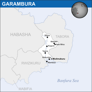
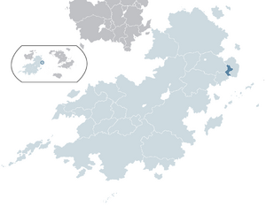 Garambura (dark blue) located within Coius (light blue). | |
 | |
| Capital | |
| Largest city | |
| Official languages | Gaullican |
| Recognised national languages | Estmerish Garamburan Sign Language |
| Recognised regional languages | |
| Ethnic groups (2017) | 90.6% Black Bahian[1] 8.2% Chennois 1.2% Other ––0.6% Yebase ––0.2% Mirite ––0.4% Other |
| Religion (2014) |
|
| Demonym(s) | Garamburan |
| Government | Unitary presidential republic |
| Sylvain Sikali | |
• Premier | Tumai Gwisai |
| Legislature | Parliament |
| Congress | |
| National Assembly | |
| Independence from Rwizikuru | |
• Declared | 16 February 1969 |
• Republic | 30 April 1969 |
• Admitted to the CoN | 5 March 1971 |
• Admitted to the CBS | 17 November 1979 |
| Area | |
• Total | 116,784 km2 (45,091 sq mi) |
• Water (%) | 3.17 |
| Population | |
• 2021 estimate | 18,104,187 |
• 2020 census | 17,507,192 |
• Density | 149.91/km2 (388.3/sq mi) |
| GDP (PPP) | 2021 estimate |
• Total | $161.6 billion |
• Per capita | $8,924 |
| GDP (nominal) | 2021 estimate |
• Total | $86.3 billion |
• Per capita | $4,768 |
| Gini (2014) | high |
| HDI (2014) | high |
| Currency | Garamburan denier (GSH) |
| Date format | dd-mm-yyyy |
| Driving side | left |
| Calling code | +181 |
| ISO 3166 code | GAR |
| Internet TLD | .gb |
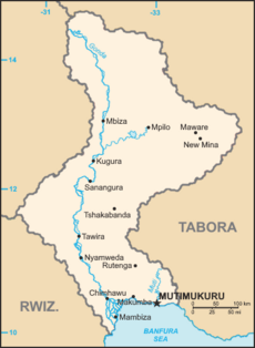
Garambura (/'gæræmbʊra:/; Gaullican: Garamboure), officially the Republic of Garambura (Gaullican: République de Garamboure), is a country in eastern Bahia, located on the continent of Coius. The River Gonda runs up most of the country. It borders Yemet to the north, Rwizikuru to the west and Masari to the east. The country's capital is Mutimukuru, while the country's largest is Mambiza. With around 17.5 million people, Garambura is one of the smallest countries in Coius and Bahia, though it also has one of the world's fastest growing populations. The country has five official languages, with veRwizi, Sisulu and Gaullican being the most prevalent.
Since the 11th century, Garambura was historically under the subjugation of the vast veRwizi Empire, who hailed from modern-day Rwizikuru. First colonial contact came when the Gaullican Lower Gonda Company under Cassien merchant and explorer Michel Masson established a trading outpost called Saint-Germaine (modern-day Mambiza) in 1656. The Gaullicans eventually worked their way inland through colonial conquest and by 1840 the entirety of Garambura was part of the Gaullican Baséland colony. Sainte-Germaine served as a major stopover for Gaullican merchants on their way to Xiaodong and the Asterias, and so the city grew quickly under colonial rule. When Rafael Duclerque's national functionalists took power in Gaullica in 1919, cultural repression began spiking on the island as previous colonial ministers were replaced with national functionalists. Many natives were conscripted into the Gaullican army and fought heavily on the Bahian front of the war. When Gaullica lost the war, Garambura was transferred to Estmere as East Riziland, a subdivision of the larger Riziland.
Garambura got its independence from Estmere under the Rwizikuru Republic, but growing authoritarianism and the declaration of Izibongo Ngonidzashe that he would become an absolute monarch spearheaded calls for Garamburan independence. The Garamburan National Front formed in 1968 under Takakunda Kuda Kani as a guerrilla paramilitary, and Garambura unilaterally declared its independence on February 16, 1969, whilst Rwizikuru was fighting over the region of Yekumavirira. The war was swift as the guerrillas won a major battle at the Battle of Mambiza on April 18, forcing the Rwizikurans to retreat. Surrounded on both sides, Izibongo met with Takakunda on April 30, 1969, in Port Fitzhubert, and agreed to fully recognise Garamburan independence. Izibongo referred to the Garamburans as "traitors" and relations with Rwizikuru did not recover until Kupakwashe Ngonidzashe came to power in 1979.
In the modern day, Garambura is a member of the ICD, CoN, the ITO and GIFA. Despite the country's fractured past, it scores well on democracy and freedom indexes.
Etymology
The name "Garambura" originates as a corrupted portmanteau of the veRwizi words Garama - meaning "life" or "lively" - and rakakura, meaning "vast". The country's official name is the Republic of Garambura, which was adopted upon independence in 1969. Unlike many other colonised nations, its etymology stems from its native language. Under Gaullican colonisation, it was referred to as Baséland, a name given to it by the Gaullicans after the Yebase people, who worked closely with the Gaullicans in the early colonial period of the country.
History
Early period
Archaeological evidence uncovered in Garambura suggests that civilised humans had inhabited the area since at least 2000 BC. Stone tools, fossilised bones and cuttings on animal bones suggest that foragers made up the majority of an early Garamburan populace. However, some archaeologists suggest these marks could have been made during the excavation process, and attribute the first humans in Garambura to be a people who inhabited a small area near modern-day Mbiza, known simply as the Vanhu peoples.
The first permanent settlers in Garambura appeared some time between 800 and 400 BC, and settled areas around the Gonda Delta, utilising the region's fertility to begin small settlements across the river. Slash and burn agriculture was used extensively and affected the early biodiversity of the region, both flora and fauna. These small settlements would exist almost independent of any other Bahian polities of the time, and the area was well-developed for pre-colonial Bahia, transforming into a loose confederacy of tribes by 800 AD, following fetishist beliefs. When the Irfanic Founagé Dominion of Heaven formed towards the end of the 9th-century, the tribesmen of early Garambura feared their traditional beliefs would be forcefully stamped out. The towns briefly united into the Akatendeka Confederacy, but were swiftly defeated by the rising Hourege system in Bahia, which would heavily influence Garamburan society after the fall of Akatendeka.
After the emergence of Hourege, many villages began to be settled up and down the Gonda River, mainly by the veRwizi and Sisulu populace, who had diverged into separate areas of the country by this point. The villages were dominated by the Hourege system, but the Banfuri coastal cities dominated, with Mutimukuru emerging to be one of the larger Hourege settlements in Bahia. Traditional society flourished in Garambura under the Houragic golden age, with the Gonda Delta settlements and Mutimukuru seeing increases in size as Pan-Bahian trade increased. The dominance of Hourege was solidifed when the area was conquered by the veRwizi Empire in the 12th century.

veRwizi Empire
The empire's rule was generally quite lax and the area did not suffer any real direct oppression. Under the golden age of the veRwizi Empire, around the 1400s, pan-Bahian trade flourished and the coastal cities of Garambura attracted merchants and tradesmen for their attractive deltas and natural harbours. The start of major trade in the area caused a massive divide between the veRwizi people of the coast, now wealthy and living lives more akin to middle-class veRwizi in Rwizikuru, and the Sisulu and Njinji peoples inland, who felt neglected by the empire's rule. They revolted in 1636, losing the revolt itself but contributing as a whole to the collapse of the empire in the 1650s, after which a Sisulu-Njinji tribal confederacy invaded the veRwizi portions of Garambura, suing them for land in the north and isolating them to the direct coast.
Confederacy of Njinjiland and the Sisulu
The confederacy would consider themselves as a regional successor to the veRwizi Empire as it collapsed back into modern-day Rwizikuru. They controlled most of Garambura and the River Gonda but were disgruntled by company presence in southern Garambura and the Gonda Delta, which was viewed as sacred by the fetishists of the confederacy. They would launch regular raids on the company-owned trade cities of the Lower Gonda, culminating in one successful raid in 1772, lead by Mabuti I, which damaged the local finances and disrupted trade to and from Gaullican colonies in Bahia and the Asterias. The Gaullican Lower Gonda Company would quickly amass an army to avenge the raids and decisively defeated the Confederacy and the 1774 Battle of Ingezi, which heavily destabilised the Confederacy and caused local rebel groups to try and secure their independence. By 1813, the confederacy had effectively ceased to exist, and most of its modern day borders were absorbed into the colony of Baséland. Some Njinji leaders are thought to have fled into rural Bahia, including into Yemet and the nearby Nyikaitsva mountains, to escape persecution by Gaullican colonial authorities.
Colonial rule
The colony of Baséland was declared as a protectorate of the Gaullican Empire, with its first governor, Robin Gaume, taking power officially on February 19, 1813. The preceding Gaullican Lower Gonda Company was nationalised and abolished by royal decree a year prior as the Gaullican crown sought to take direct control over the area for its imperial ambitions. Explorations and documentations of Baséland north of the Gonda delta began in 1820, under Gaullican explorers Timothée Fabre, Jehan Traver and Patrice Pasternoste. Sponsored by the crown, the trio explored and vaguely mapped much of central and northern Baséland, including the Gonda Valley, Gibixego forest and Lusulu forest. Maware was discovered and documented by Pasternoste in 1823, and was the first major pre-colonial city the Gaullicans discovered. The head of Mabuti I, Karame of the Njinji, was also discovered by Pasternoste and donated to the Musée de l'histoire baïenne in Verlois that same year.

In the middle of the 19th century, Gaullica expanded the area military, building an assortment of coastal forts and a naval docks in Sainte-Germaine and across the coast throughout the 1850s. Major Gaullican naval assets were moved to Sainte-Germaine's large and expanded port and the city benefitted massively from becoming a global trade entrepot under the Gaullican Empire. The Gaullicans made use of the Yebase, traditional nomadic peoples originating from Yemet that often ran and administered specific aspects of the colony. The Yebase was a Sotirian people, whose status in colonial society was semi-equal to that of the white settler populations. The Chennois demographic of Sainte-Germaine expanded massively during this era as Gaullica encouraged settlement in the area to transform it into one of its prestigious colonial cities. Didier Maxime Rhissassi led a major expedition northwards that produced the first detailed maps of Maware and northern Garambura, assisting in the assertion of absolute Gaullican control in the area. Alphonse Amsalu sunk the Gaullican ship Insulaire off the coast of Sainte-Germaine in 1884, during the height of the Sougoulie rebellions, which destroyed the relationship between the settlers and the Yebase and started the first major Pan-Bahian literary revolution in the colony, with influential authors such as B.S.E. Mercier, Otes Touré and Louis Larue publishing their works around this time. With this legacy, the city of Sainte-Germaine hosted the Conference for the Promotion of the Pan-Bahian Idea, gathering an assortment of Pan-Bahian advocates, philosophers, historians and authors to discuss the future of Bahia.
Charles Dumont became governor of the colony in 1906, beginning a thirteen-year-long tenure marked with landmark liberal reforms, including the Vivien Lemaigre case in 1907, which affected the status of white landowners relations with their indentured workers. Demont was captured and executed in 1919 by the Parti populaire during their takeover in Gaullica in what is now celebrated domestically as Droits de l'homme day. High militarisation levels as well as conscription into the Tirailleurs bahiens followed under functionalist rule. Throughout the war, Gaullican colonies enjoyed success in the Bahian front, but with the fall of mainland Gaullica in 1934, surrendered to Allied forces towards the end of the year.
Baséland was sought after by many Euclean powers, mainly Etruria, who wished to expand their colonial influence with the prestige and development of the colony. Ultimately, through political posturing and an unwillingness from Werania and Estmere to succumb to Etruria's major colonial ambitions, the colony fell to Estmere, who merged into the existing colony of Riziland in 1935. Estmerish colonial rule was comparatively lax as authorities prepared the colony for its independence. Over this time, Indigénisme developed as a political ideology in the 1930s and 1940s, with the eventual goal of creating a racially-segregated Baséland. The idea never came to fruition, despite its popularity among Chennois people, and Baséland remained a part of the new Republic of Rwizikuru when it declared its independence in 1946, becoming the District of East Riziland.
Modern history
In 1946, East Riziland became an autonomous province under Rwizikuru. Estmerish was introduced as a national language and its teaching was made mandatory in schools alongside Gaullican and another native language, and many political movements calling for self-determination were suppressed by the Rwizikuran government. Cultural differences also contributed to an extremely negative relationship between the central government and the people of East Riziland. The 1947 Sainte-Germaine riots called for self-determination, but were brutally repressed by the Rwizikuran government and the province's autonomy docked at a result. The promotion of Pan-Bahianism saw the United Bahian Republic form in 1954. New Mina began construction as the planned capital of the republic that same year.
Political instability and disagreements between the Masahari and Rwizikuran governments, as well as the proclamation of Izibongo Ngonidzashe as Mambo of Rwizikuru in 1964, caused the UBR to dissolve in 1965. The political vacuum and uncertainty caused by the republic's dissolution gave rise to further calls for independence in East Riziland, and protests soon followed. After further brutal repressions in 1966 and 1968, the East Riziland Liberation Front formed in late 1968, led by Gen. Fazile Maqoma. In February 1969, Garambura declared independence, starting a brief conflict that coincided with the Mabifian-Rwizikuran War. Overstretched supplies, poor logistics and overall low morale led to Garambura securing its independence on April 30, 1969, with the Treaty of Bazadavo signed in Dezevau by Garamburan representatives Takakunda Kuda Kani and Papa Kadu.
First elections were held in October 1969, and were won by Takakunda's Garamburan National Party. Garambura was accepted into the Community of Nations in 1971, and by then had garnered most of the world's recognition as a sovereign state. A year prior, Mutimukuru had been designated as the country's capital, and the legislature and judiciary were moved from Mambiza in 1972. Takakunda won re-election in 1974 after a successful first term as president. In 1975, the Kulo State insurgency spilled over into Garambura as estranged and neglected Kulo minorities took up open arms against the government, after small exchanges with Garamburan military units in August, Garambura stood down in the area, deeming losses too high. The northern areas of the Culloland province remained under rebel control until 1977, when a renewed Garamburan offensive drew them out of the country's borders. At the same time, the Mabifian Democratic Republic was undergoing major civil strife as the socialist government lost power to local warlords and generals. Hassan Babangida, leader of the Mabifian Patriotic Movement, visited Garambura in 1978, and was regarded as an admirer of Takakunda Kuda Kani and his successful model of democracy in Bahia. Garambura somewhat oversaw the Mabifian transition to democracy in the late 1970s. A period of rapprochement between Garambura and Rwizikuru began with the ascension of Kupakwashe Ngonidzashe to Rwizikuru's throne in 1979, and Garambura joined the Congress of Bahian States in 1979.
In 1981, Takakunda announced that he would not be running for another term after his current one ended in 1984. He was succeeded by Tapfuma Mkondo, who was largely a political disciple of Takakunda and continued his policies through to 1989, when he succeeded by Jongwe Mujuru. Mujuru began the promotion of local native languages throughout the country to try and prevent them from being assimilated into more major languages. In the 1990s, Garambura's population and economy were one of the fastest growing in the world, and Mambiza was expanding rapidly, which saw the emergence of shanty towns throughout the city as the property market failed to keep up with the city's growing population. Louis Jezilé was elected in 1999, and in 2000 joined the International Forum for Developing States, an organisation led by south-south cooperation principles. In 2002, Garambura became an economic associate of the Council for Mutual Security and Development, and combined funding from the two contributed greatly to the expansion of Garamburan infrastructure. Jazilé's assassination in 2010 by Kulo-affiliated militants brought a renewed resurgence in military insurgence in Culloland, and Garambura still retains military presence there to this day. The first coalition government between the Garamburan National Party and the Forum for Change emerged in 2011 with the resignation and defection of various ministers. The current president in Sylvain Sikali, who was elected in 2020.
Geography
Garambura is located in eastern Bahia, with a 168 km (104 mi) coastline on the Banfura Sea, where most of its population is located. It lies between longitudes 10°N and 15°N and latitudes 30°W and 34°W. Garambura has an area of 104,491 sq km (40,344 sq mi), making it the smallest country on mainland Coius. Garambura shares borders with two sovereign states, the Kingdom of Rwizikuru to the west, and the Republic of the Adésine to the north-west.
Garambura's geography is dominated by the River Gonda, which runs the entire the length of the country. Most of Garambura's population and urban areas lie on the Gonda, which runs a total length of 604 km (375.3 mi) within the borders of the country. Due to Garambura's rurality outside of the coastline, the Gonda is known for its expansive meanders, as well as its large oxbow lakes which have formed as a result of meanders joining and disconnecting larger meanders. Oxbow lakes can be across most of the country where the Gonda flows. As well as oxbow lakes, Garambura has a significant amount of freshwater and saltwater lakes, which are scattered out across the country. Lake Msosa, previously known as Lake Stephanie until 1977, is the country's largest lake, and is a freshwater lake located in the Gibixego Nature Reserve.
The tallest point in Garambura is the peak of Mt. Kabwata, located at the eastern end of the Nyikaitsva mountains, a larger mountain range spanning most of Rwizikuru, but ending in Garambura. Mt. Kabwata is located 1,627 m (5,338 ft) above sea level, and is a regular tourist destination for hikers and climbers due to its relative ease to climb and peakside views. The lowest point in Garambura is the floor of Lake Kangalongolo at 57 m (187 ft) below sea level.
Much of Garambura is covered by subtropical rainforests, around 86%, that experiences humid and wet climates throughout most of the year. Mangroves also exist on the country's coastline, although are fairly rare and limited to the Jilonga Mangroves around 20 miles west of the country's capital of Mutimukuru. The country also possesses some of the most extensive environmental protection legislation in Bahia, with around 40% of the country's forests designated as protected reserves. The Gibixegu Nature Reserve, Gonda Valley Nature Reserve, and Lusulu Village Nature Reserve are among the most expansive untouched natural habitats in Bahia.
Geology
Garambura is known for its diverse geology and mineral resources, being a producer of minerals such as coal, copper, iron ore and tin, as well as having large deposits of valuable resources like diamonds and gold, the latter of which the country possesses the largest deposits in Bahia.
Climate
Much of Garambura is subject to a tropical climate with some large-scale local variations. Towards the east of the country, away from the Gonda, the climate is known for its heat and aridity, whilst the western portion of the country nearer to the Gonda is known for its vast rainforests, its humidity, mild temperatures and large amounts of rainfall. The country rarely experiences prolonged drought periods, although the city of Maware in the east has been known for its longer-than-usual dry periods. However, schemes are beginning to be put in place that transfer water from the river Gonda into reservoirs in the Lusulu Village National Park, some 20 miles south of Maware.
Flora and fauna
Garambura is home to an extremely diverse selection of local flora and fauna, with most of the country covered in tropical rainforests and inhabited by numerous species of animal, many of which are unique to the area. Many nature conservationist organisations estimate there are over 500 unique species of mammal, reptile and amphibious creatures in Garambura, and the country works closely with these organisations to preserve the wildlife. An estimated 85% of the country is covered by rainforest, down from around 92% in 1979, which has caused some groups to raise concern for deforestation in Garambura, much of which is illegal and untracked by the government.
Environmental issues
In recent years, the government of Garambura have begun numerous programs in order to prevent the degradation of the country's environment, particularly its rainforests. Illegal deforestation is a problem in the country, especially in the north and east, where settlements and scarce and illegal foresters can conduct slash and burn techniques on vast swathes of the forest. In 2013 especially conservationist efforts for wildlife spiked up significantly when the Banfura ray was declared extinct, having been targeted by fisheries along the south coast for years.
Politics and government
Administrative divisions
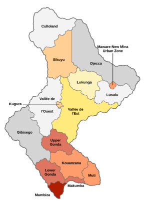
Garambura is subdivided into sixteen separate departments, each of which elect separate local councils but are not granted any federal devolvement from the central government. Each department is also divided into multiple cantons (or districts in Mambiza, Kugura and the Maware-New Mina UZ), which usually comprise one significant or large town within the department as well as its surrounding villages or urban sprawl. Funding for local projects is distributed by the central government on a provincial level, then further distributed on a cantonal level by the department's local council.
| Department | Capital | Population (2016) |
|---|---|---|
| Culloland | Rashamira | 38,716 |
| Djecca | Mukutukutu | 85,412 |
| Gibixego | Makado | 98,056 |
| Kouanzana | Ngezi | 744,952 |
| Kugura | Kugura | 416,775 |
| Lower Gonda | Nyamadzavo | 1,615,991 |
| Lukunga | Mpilo | 126,889 |
| Lusulu | Mabuva | 33,101 |
| Makumba | Makumba | 1,981,726 |
| Mambiza | Mambiza | 7,516,282 |
| Maware-New Mina Urban Zone | New Mina | 712,408 |
| Muti | Mutimukuru | 671,625 |
| Sikuyu | Mbiza | 418,614 |
| Upper Gonda | Tawira | 1,167,772 |
| Vallée de l'Est | Sanangura | 371,954 |
| Vallée de l'Ouest | Uhera | 41,018 |
Law and judiciary
Foreign relations
Military
Economy
Garambura is widely considered as a developing/emerging economy, with a growing tertiary sector that has seen more of the population become employed in general services. It is one of the most developed economies in Bahia, and despite its small population, has the highest real GDP of any Bahian nation. Its nominal and PPP GDPs per capita are significantly above the regional average, and has given Garambura the leverage to become a developing trade and business hub for Bahia's rapidly expanding markets. Integration with both regional and international economies has also helped the economy grow in recent years.
Most of the country's workforce, around 65%, is employed in agriculture and industry. Garambura's low population density allow for large-scale livestock and crop farms. It is a significant exporter of meats such as beef and chicken, as well as valuable food goods such as coffee and cocoa. In addition to this, Garambura's rich natural resources make it a large exporter of bauxite, cobalt, copper, diamonds, iron and nickel. More recently, international investment from organisations such as COMDEV and the IFDS have stimulated Garambura's natural resource industries.
Despite its economic success, the country still struggles with poverty and underemployment, particularly in its large urban agglomerations. Over 20% of the country still lives below the poverty line, and in rural departments poverty can exceed rates of over 60%. Underemployment is a significant problem in cities such as Mambiza, and large shanty towns have formed in the city as a result. Unemployment rates usually fluctuate between 35–45%.
Natural resources
Tourism
Services
Science and technology
Demographics
| Historical population | ||
|---|---|---|
| Year | Pop. | ±% p.a. |
| 1900 | 287,162 | — |
| 1930 | 872,819 | +3.78% |
| 1936 | 916,278 | +0.81% |
| 1946 | 1,291,827 | +3.49% |
| 1960 | 1,907,816 | +2.82% |
| 1970 | 2,162,810 | +1.26% |
| 1980 | 4,012,716 | +6.38% |
| 1990 | 6,564,731 | +5.05% |
| 2000 | 9,871,554 | +4.16% |
| 2010 | 12,882,103 | +2.70% |
| 2020 | 17,507,192 | +3.12% |
| 2021 (est.) | 18,104,187 | +3.41% |
Ethnicity
Language
Garambura is an incredibly linguistically diverse country. With 25 languages recognised in some form or another by the government, it is one of the most diverse on the planet. The sole official language in Garambura is Gaullican, used as both an official language and vernacular language in some parts of the country. Estmerish is also recognised as a national language from its usage in neighbouring Rwizikuru as well as its elevated importance during the period of the United Bahian Republic. Despite only a small fraction of the country speaking Estmerish (almost none natively), it still enjoys usage in various diplomatic documents and other official purposes.
Garambura's indigenous languages make up the overwhelming plurality of its linguistic structure. Most of these languages are part of the Rizi-Gondic language group, and only two (!Kibito and ǂ'Adingi are not part of it. Both of these languages are part of the isolate Shukusanga language group, which is endemic to much of southern Bahia. These languages are notable for their use of click consonants, which are extremely rare in the world's languages. Speakers of Shukusanga languages are concentrated mainly in the rural eastern forests and plains of the country.
Despite its large number of recognised languages, it still only constitutes around 30-40% of Garambura's native spoken languages. Linguists estimate that there are at least 60 languages native to Garambura, many of which are native to a small areas such as rural towns and villages. Many of these languages see daily usage within families or small communities, but on a larger scale they have been assimilated over time as more widespread languages emerged as regional vernacular languages in the 1960s and 1970s. These languages include veRwizi and Sisulu in the south (including the city of Mambiza), Eastern Molisa in the west near the border with Rwizikuru, Western Nbunguma in the east on the border with Masari and Njinji in the more rural north. !Kibito also serves as a more minor shared language between speakers of the Shukusanga languages.
Immigration and emigration
Urbanisation
Religion
Education
Health
Culture
Arts and literature
Cuisine
The cuisine of Garambura has been influenced over time by a multitude of different cultures and cuisines, including Rahelia, West Bahia, North Bahia, Gaullica and less predominantly Satrian and South-eastern Coian cuisines. Garambura's cuisine heavily features livestock such as beef, chicken, lamb and pork, and its coastal location has given importance to fish in local cuisine.

Popular Garamburan dishes including thieboudienne, a fish dish marinated in lemon, garlic and various herbs, then cooked in tomato paste with rice and vegetables. Thieboudienne is closely related to jollof, commonly found in Mabifian cuisine. Ugali is a common form of porridge made from cornmeal, and is usually eaten at breakfast. Garamburan yellow rice is a popular side dish to curries and other savoury dishes, and is made from cooking fragrent rice in turmeric as well as cinnamon, which gives it its distinct sweetened taste. Suya is also popular and generally consists of spicy skewered meat cooked on a barbecue.
Throughout the 18th and 19th centuries, new crops and foods were introduced into Garamburan cuisine through trade. Cassava, natively known as manioc, is an immensely popular food introduced from Satucin in the 18th century. Its uses include matapa, a stew cooked using young cassava leaves, often adding seafood such as crab and cooking in coconut milk, as well as cassava leaf sauce, a thick paste prepared using cassava, dried fish and onions. The sauce can also include okra, another popular crop introduced through trade.
As well as crops from the new world, cuisine from northern Coius influenced Garamburan cuisine. Popular with Tsabaran traders, harira, a soup of Rahelian origin, has since become popular with locals in Garambura. Mahdjouba are also a popular street food in Garambura, and are pancakes made from semolina dough, wheat flour and olive oil.
Chennois cuisine takes a more consistent form of influence from Euclean cuisine and Gaullican cuisine. Viande poivrée are popular among the Chennois community, dried strips of meat seasoned with black pepper and coriander and dried for preservation. It is often considered beef jerky and shares many commonalities in both preparation and consumption. Snowballs, also known locally as mekéalam, are balls of fried dough infused with sweet syrup and covered in shredded coconut.
Music
Garambura is renowned for its relative diverse array of music for both its size and location, having been the location of pioneers of worldwide genres such as jazz and house, as well as localised genres such as djeli pop and gondaphonics. Garambura's burgeoning music scene, both presently and historically, has allowed it to be a large cultural exporter of music both in Bahia and across the world.
Traditionally, veRwizi and Sisulu music focussed heavily around percussion instruments, most frequently the karyenda, a type of Bahian drum. These drums were used for the creation of both culturally sacred and leisurely music, and their use during the coronation ceremonies of karames during the Houregic period is well-documented. Historians also speculate that during Mabhuti's raids of Sainte-Germaine in the 18th century, these drums were also used as war drums to intimidate the enemy. Other traditional instruments like the balafon have also been found in Garambura, and were likely exported or brought over from modern-day Mabifia during the Bahian Consolidation.
Modern Garamburan music began with the explosion in popularity of djeli pop, a subgenre of traditional Bahian folk music mixed with elements of the popular music of the time. Pioneered by Honorine Uwineza in Mabifia and refined by many artists in Garambura, djeli pop became the first quasi-mainstream genre to originate from Bahia. Garamburan musician Chloe Kolisi became the face of Garamburan djeli pop and the emerging Club Mambiza in the 1970s, a harder, brasher iteration of its predecessor that earned a dedicated fanbase in the Asterias' and Euclea's emerging punk rock fandoms. Kolisi toured across eastern Euclea, notably being barred from entry into Estmere after authorities concluded her music and tours correlated with a rise of ethnic violence within the country. Garamburan disk jockey DJ Kuvaka is also credited with pioneering some of the first house records during sets played at the Clube das Palmas in Mambiza in 1985, extensively utilising sampling, which would become a mainstay feature of future Garamburan genres.
In the 21st century, Garamburan music has been characterised by a return to traditional roots with significant modern influence. The emergence of mbalax from Mabifia has given a rise to some of Garambura's notable folk singers and acts, including Karam Hy and The Nokutenda Olonga Quintet, who often use traditional instruments such as the karyanda and balafon in their music. Mbalax, and folk in general, is popular among Garambura's rural communities. Urban scenes have seen the emergence of gondaphonics, an electronic, industrial take on Bahian folk music. Gondaphonics is sometimes characterised as house music, but it's popularity in recent times has seen it characterised as its own genre, and was pioneered by music group Ukuvuselelwa kweNtlalo in Mambiza in the mid-2000s.
Sport
Notes
- ↑ Refers to Garambura's 23 officially-recognised ethnic groups.


