List of highest points of Astyrian countries: Difference between revisions
Jump to navigation
Jump to search


mNo edit summary |
mNo edit summary |
||
| Line 2: | Line 2: | ||
==Countries and territories== | ==Countries and territories== | ||
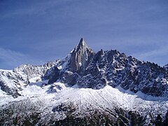
[[File:Mount Aeneas.jpg|thumb|240px|right|[[Mount Aeneas]] is the highest point in East Astyria]] | [[File:Mount Aeneas.jpg|thumb|240px|right|[[Mount Aeneas]] is the highest point in Ixalia and East Astyria]] | ||
[[File:Sajama National Park.jpg|thumb|240px|right|[[Torúmalana]] is the highest point in West Astyria]] | [[File:Sajama National Park.jpg|thumb|240px|right|[[Torúmalana]] is the highest point in Teudallum and West Astyria]] | ||
[[File:Carstensz Mountain.jpg|thumb|240px|right|[[Carstensz Mountain]], the highest point in Sythith]] | [[File:Carstensz Mountain.jpg|thumb|240px|right|[[Carstensz Mountain]], the highest point in Sythith]] | ||
[[File:Margherita-Peak-border-Mount-Stanley-Ruwenzori-Range.jpg|thumb|240px|right|[[Mons Caligo]], the highest point in Hesperidesia]] | [[File:Margherita-Peak-border-Mount-Stanley-Ruwenzori-Range.jpg|thumb|240px|right|[[Mons Caligo]], the highest point in Hesperidesia]] | ||
| Line 92: | Line 92: | ||
|38||{{flag|Noordenstaat}}||[[Willemspiek]]||{{convert|1095|m|ft|0|abbr=on}}|| | |38||{{flag|Noordenstaat}}||[[Willemspiek]]||{{convert|1095|m|ft|0|abbr=on}}|| | ||
|- | |- | ||
|39||{{flag| | |39||{{flag|Alcantara}}||[[Monte de Santa Teresa]]||{{convert|1068|m|ft|0|abbr=on}}|| | ||
|- | |- | ||
|40||{{flag| | |40||{{flag|Plätteisen Adler}}||[[Hill]]||{{convert|616|m|ft|0|abbr=on}}|| Needs a name | ||
|- | |- | ||
|41||{{flag|Valle Crucis}}||[[Mons Silva]]||{{convert|404|m|ft|0|abbr=on}}|| Needs a better name | |41||{{flag|Valle Crucis}}||[[Mons Silva]]||{{convert|404|m|ft|0|abbr=on}}|| Needs a better name | ||
Latest revision as of 19:30, 5 May 2024
This is a list of sovereign states and dependent territories in Astyria by their highest points above sea level.
Countries and territories
File:Mount Aeneas.jpg
Mount Aeneas is the highest point in Ixalia and East Astyria

Torúmalana is the highest point in Teudallum and West Astyria
File:Carstensz Mountain.jpg
Carstensz Mountain, the highest point in Sythith

Mons Caligo, the highest point in Hesperidesia

Mount Ciel, the highest point in Lorecia
Dependent countries, overseas territories and countries with disputed sovereignty are listed in italics. Mother countries or claimants are indicated in parentheses. This list includes all countries and territories that are listed by ISO 3166-1.
| 1 | Mount Aeneas | 6,893 m (22,615 ft) | Highest point (i.e. elevation) in Ixalia. | |
| 2 | Torúmalana | 5,711 m (18,737 ft) | Highest point in Teudallum. | |
| 3 | Carstensz Mountain | 5,188 m (17,021 ft) | Highest point in Sythith. | |
| 4 | Mons Caligo | 5,124.3 m (16,812 ft) | Highest point in Hesperidesia. | |
| 5 | Jabal al-Awan | 5,043.8 m (16,548 ft) | ||
| 6 | Triglav | 4,616 m (15,144 ft) | ||
| 7 | Mount Ciel | 4,589 m (15,056 ft) | Highest point in Lorecia. | |
| 7 | Mount Ciel | 4,589 m (15,056 ft) | Highest point in Lorecia. | |
| 9 | Mount Ukhamba | 4,532.7 m (14,871 ft) | ||
| 10 | Mount Asteres | 4,239 m (13,907 ft) | ||
| 11 | Txin Tiyaia | 4,227 m (13,868 ft) | ||
| 12 | Beinn Maoirthighearna | 4,026 m (13,209 ft) | ||
| 13 | Montparnasse | 3,412 m (11,194 ft) | ||
| 14 | Korkenvuori | 3,267 m (10,719 ft) | ||
| 15 | Slávu | 2,877 m (9,439 ft) | ||
| 16 | Mont Darc | 2,815 m (9,236 ft) | Needs a better name | |
| 16 | Wulckneberga | 2,798 m (9,180 ft) | ||
| 18 | Gorblanhail | 2,625 m (8,612 ft) | ||
| 19 | Mount Igbeti | 2,538.7 m (8,329 ft) | ||
| 20 | Varddi (disputed by Belka) | Njullávarri | 2,402 m (7,881 ft) | |
| 21 | Stragonorvia | 2,378 m (7,802 ft) | ||
| 22 | Mount Archer | 2,376 m (7,795 ft) | ||
| 23 | Shuhatlaliaxu | 2,248 m (7,375 ft) | ||
| 24 | Fichtelberg | 2,234 m (7,329 ft) | ||
| 25 | Mons Sancte Maria | 2,139 m (7,018 ft) | ||
| 26 | Hírímlad | 2,120 m (6,955 ft) | ||
| 27 | Mount Oso | 1,947 m (6,388 ft) | ||
| 28 | Template:Country data South Kamalbia | Mount Kimepra | 1,887 m (6,191 ft) | |
| 28 | File:Flag of Oduya.png Oduya | Mount Kimepra | 1,887 m (6,191 ft) | |
| 30 | Xudatoy | 1,634 m (5,361 ft) | ||
| 31 | Nhialyok Ridge | 1,628 m (5,341 ft) | ||
| 32 | Gaokidi plateau | 1,614 m (5,295 ft) | ||
| 33 | Monte Titan | 1,412 m (4,633 ft) | ||
| 34 | Volksberg | 1,344 m (4,409 ft) | ||
| 35 | Vekh Neramë | 1,163 m (3,816 ft) | ||
| 36 | La Sagra | 1,148 m (3,766 ft) | ||
| 37 | Vegi Kroreg | 1,109 m (3,638 ft) | ||
| 38 | Willemspiek | 1,095 m (3,593 ft) | ||
| 39 | Monte de Santa Teresa | 1,068 m (3,504 ft) | ||
| 40 | Template:Country data Plätteisen Adler | Hill | 616 m (2,021 ft) | Needs a name |
| 41 | Mons Silva | 404 m (1,325 ft) | Needs a better name | |
| 42 | Kuninga iste | 322 m (1,056 ft) | ||
| 43 | Biryn Taal | 296 m (971 ft) | ||
| 44 | Greenemund | 271 m (889 ft) |
References
| Continents |  | ||||||||
|---|---|---|---|---|---|---|---|---|---|
| Law and politics | |||||||||
| Economics | |||||||||
| Demographics | |||||||||
| Intergovernmental organisations |
| ||||||||
| Culture |
| ||||||||