Transport in Mascylla: Difference between revisions
No edit summary |
No edit summary |
||
| Line 16: | Line 16: | ||
==Roads== | ==Roads== | ||
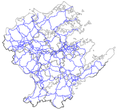
[[File:Autobahn map Mascylla.png|230px|thumb|right|Map of the Mascyllary ''Autobahn'' road network]] | |||
==Air transport== | ==Air transport== | ||
===Airlines=== | ===Airlines=== | ||
Revision as of 18:39, 6 March 2020
This article is incomplete because it is pending further input from participants, or it is a work-in-progress by one author. Please comment on this article's talk page to share your input, comments and questions. Note: To contribute to this article, you may need to seek help from the author(s) of this page. |
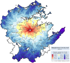
Transportation in Mascylla relies on one of the densest transportation and infrastructure networks of the world with 129 km or roadway and 5.8 km of rail lines per 100 km2, and is needed by Mascylla, a densely populated, economically developed country in central Erdara. Rail, road, air and water are all suffisticated and widely developed means of transportation in Mascylla.
All activities and affairs of transportation is overseen by the Ministry of Infrastructure of the Realm of the Mascyllary government.
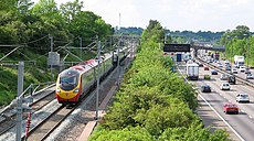
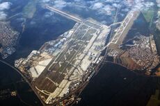
One of the world's first large-scale highway systems, the Autobahn is a nation-wide system of highways and roads. The country's most important waterways are the rivers Blaugold, Röhrn and Warne, as well as a canal system connecting the three rivers and Lake Sigismund respectively; the largest mairitime port is that of Flussmund at the mouth of the Blaugold. Königsreh–Albert Polschnitz Airport is the largest aiport in Mascylla and a large international hub of air travel and transport in Erdara. Air travel in general is rarely used for inland flights, mainly due to its suffisticated road and rail network, but nevertheless competes with Mascylla's Gekrönte Bahn, the state-owned railway operator. High- and medium-speed trains such as the ILE (InterLandExpress) connect urban areas, with passengers and cargo able to move at 370 km/h between cities. Most Mascyllary cities have a connection to rapid transit capabilities and public transport is provided by state.
