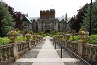
This article belongs to the lore of Anteria.

Gallatin: Difference between revisions

Jump to navigation Jump to search
No edit summary
 
(107 intermediate revisions by the same user not shown)
Line 1: Line 1:
{{DISPLAYTITLE:Port Victoria}}
{{Infobox settlement
|name                    = Gallatin
|name                    = Port Victoria
|native_name            =  
|native_name            =  
|native_name_lang        = <!-- ISO 639-1 code e.g. "fr" for French. If more than one, use {{lang}} instead -->
|native_name_lang        = <!-- ISO 639-1 code e.g. "fr" for French. If more than one, use {{lang}} instead -->
|settlement_type        = Capital City and Region
|settlement_type        = Capital City
|image_skyline          =  
|image_skyline          =  
{{Photomontage
{{Photomontage
| photo1a = NGI - Imgur.jpg
| photo1a = Port Victoria Skyline.jpg
| photo1b =  
| photo1b =  
| photo1c =  
| photo1c =  
| photo1d =  
| photo1d =  
| photo1e =  
| photo1e =  
| photo2a = NGI - Imgur (1).jpg
| photo2a = Mansion District NGI.jpg
| photo2b =  
| photo2b =  
| photo2c =
| photo2c =
| photo2d =
| photo2d =
| photo2e =
| photo2e =
| photo3a = NGI - Imgur (2).jpg
| photo3a = NGI 12.jpg
| photo3b =  
| photo3b =  
| photo3c =
| photo3c =
| photo3d =
| photo3d =
| photo3e =
| photo3e =
| photo4a = NGI - Imgur (3).jpg
| photo4a = NGI National Assembly Building.jpg
| photo4b =  
| photo4b =  
| photo4c =
| photo4c =
| photo4d =
| photo4d =
| photo4e =
| photo4e =
| photo5a = Gough City Hall - Imgur.jpg
| photo5a = NGI Supreme Court.jpg
| photo5b =  
| photo5b =  
| photo5c =
| photo5c =
| photo5d =
| photo5d =
| photo5e =  
| photo5e =  
| photo6a = Gough City Government Square - Imgur.jpg
| photo6a = NGI Cheif Executive Res.jpg
| photo6b =  
| photo6b =  
| photo6c =
| photo6c =
| photo6d =
| photo6d =
| photo6e =
| photo6e =
| photo7a = BC Art M - Imgur.jpg
| photo7a = NZ-New Gough Island Images.jpg
| photo7b =  
| photo7b =  
| photo7c =
| photo7c =
| photo7d =
| photo7d =
| photo7e =
| photo7e =
| photo8a = Stretfield Park neighborhood Fenburg - Imgur.jpg
| photo8a = NZ-New Gough Island Images 2.jpg
| photo9a = Tram in the city - Imgur.jpg
| size =  
| size =  
| spacing = <!-- Number indicating width of spacing between the images (default: 1) -->
| spacing = <!-- Number indicating width of spacing between the images (default: 1) -->
Line 54: Line 54:
|imagesize              =  
|imagesize              =  
|image_alt              =  
|image_alt              =  
|image_caption          = From top to bottom: Gallatin seen from the City Observatory, State Street in Central City, Pinehurst Neighborhood, Conifer Ave in Central City, Gallatin City Hall, Bernard Square, National Museum of Art, Fenburg Park Neighborhood, Cava 3 Tram traveling down a street in the Central City 
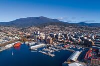
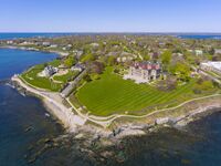
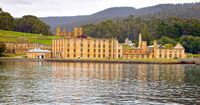
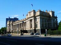
|image_caption          = From top to bottom: Port Victoria skyline, Mansion District, New Gough Island National History Museum, New Gough Island National Assembly Building, New Gough Island Supreme Court Building, New Gough Island Executive Mansion, Battey Point Neighborhood, Old Town Port Victoria
|image_flag              =
|flag_alt                =  
|flag_alt                =  
|image_seal              =  
|image_seal              =  
Line 77: Line 76:
|subdivision_name        = [[New Gough Island]]
|subdivision_name        = [[New Gough Island]]
|subdivision_type1      = Region
|subdivision_type1      = Region
|subdivision_name1      = [[Gallatin]]
|subdivision_name1      = South East Islands
|subdivision_type2      =  
|subdivision_type2      = Municipality
|subdivision_name2      =  
|subdivision_name2      = [[Gallatin| Port Victoria]]
|subdivision_type3      =  
|subdivision_type3      =  
|subdivision_name3      =  
|subdivision_name3      =  
Line 88: Line 87:
|seat                    =  
|seat                    =  
|government_footnotes    =  
|government_footnotes    =  
|leader_party            =  
|leader_party            = [[Liberal Democratic Party (New Gough Island)|LDP]]
|leader_title            = Executive Mayor  
|leader_title            = Mayor  
|leader_name            = James Parker
|leader_name            = James Parker
|unit_pref              = US<!-- or UK -->
|unit_pref              = US<!-- or UK -->
Line 104: Line 103:
|area_blank2_title      =  
|area_blank2_title      =  
<!-- square miles -->
|area_total_sq_mi        = 80
|area_total_sq_mi        = 50
|area_land_sq_mi        = 75
|area_land_sq_mi        = 36
|area_water_sq_mi        = 5
|area_water_sq_mi        = 14
|area_urban_sq_mi        = 380
|area_urban_sq_mi        = 410
|area_rural_sq_mi        =  
|area_rural_sq_mi        =  
|area_metro_sq_mi        = 1,982
|area_metro_sq_mi        = 2,800
|area_blank1_sq_mi      =  
|area_blank1_sq_mi      =  
|area_blank2_sq_mi      =  
|area_blank2_sq_mi      =  
Line 127: Line 126:
|elevation_ft            =  
|elevation_ft            =  
|population_footnotes    =  
|population_footnotes    =  
|population_as_of        = 2023
|population_as_of        = 2024
|population_total        = 987,000
|population_total        = 179,000
|population_density_sq_mi = 13,160
|population_density_sq_mi = 4,972
|population_urban = 2,190,000
|population_urban = 1,290,000
|population_metro = 2,410,000
|population_density_urban_sq_mi = 3,146.3
|population_metro = 1,680,000
|population_density_metro_sq_mi = 600
|population_note        =  
|population_note        =  
|population_demonym      = Gellatiner
|population_demonym      = Port Victorian
|timezone1              =  
|timezone1              =  
|utc_offset1            =  
|utc_offset1            =  
Line 147: Line 148:
|footnotes              =  
|footnotes              =  
}}
}}
'''Gallatin''' is the capital city and largest city of the Republic of [[New Gough Island]]. It is the second largest city and the anchor of the Greater Gallatin Area which includes the Gallatin City Region and part of the Parasides Island Region. The city has a population of 987,000 people as of the 2023 estimate. The city is the most densely populated city in the country. Located in the northern area of the country which houses 84% of the national population in 20% of the land area.
'''Port Victoria''' is the capital city of the New Gough Island. It is the 5th largest city of New Gough Island. The Greater Port Victoria is the second largest metro area in the country home to 1.098 million people.
 
The city was founded in 1718 but not proclaimed capital of the country until 1870. The city is well known for its historic architecture and art scene. Gallatin and the Parasides Island as a whole is connected to the mainland (Gough Island) by the 1 1/2-mile-long road and rail President Frank Berman Memorial Bridge. The city has a robust transit system connecting itself to the suburbs by commuter rail. Bus and street trams are the main features of the transit system. With a subway system under construction to improve transit in the city. The city has a network of freeways outside of the city limits.
 
The city attracts the largest amount tourists to the country, with many arriving in the city to travel to the nature and rugged outdoors oriented vast South Area. On average, 8-10 million tourists visit the city each year. For this reason, the city is called the Gateway to New Gough Island. Tourist attractions include: the several historic parks in the city, the National Museum of Art, Bernard Square, City Observatory, national monuments, and much more.               
 
==History==
 
==Geography==
===Climate===
{{Weather box|width=auto
|location = City Observatory, Gallatin, New Gough Island, 1991–2020 normals, extremes 1900–present
|single line = Y
| Jan high F = 63
| Feb high F = 61
| Mar high F = 55
| Apr high F = 47
| May high F = 44
| Jun high F = 42
| Jul high F = 41
| Aug high F = 41
| Sep high F = 43
| Oct high F = 48
| Nov high F = 54
| Dec high F = 58
|year high F =
|Jan mean F =
|Feb mean F =
|Mar mean F =
|Apr mean F =
|May mean F =
|Jun mean F =
|Jul mean F =
|Aug mean F =
|Sep mean F =
|Oct mean F =
|Nov mean F =
|Dec mean F =
|year mean F =
| Jan low F = 50
| Feb low F = 46
| Mar low F = 42
| Apr low F = 36
| May low F = 32
| Jun low F = 27
| Jul low F = 24
| Aug low F = 25
| Sep low F = 28
| Oct low F = 34
| Nov low F = 41
| Dec low F = 45
|year low F =
|Jan record high F = 80
|Feb record high F = 79
|Mar record high F = 77
|Apr record high F = 72
|May record high F = 64
|Jun record high F = 59
|Jul record high F = 54
|Aug record high F = 52
|Sep record high F = 58
|Oct record high F = 63
|Nov record high F = 68
|Dec record high F = 73
|year record high F = 80
|Jan record low F = 36
|Feb record low F = 32
|Mar record low F = 22
|Apr record low F = 10
|May record low F = 1
|Jun record low F = -9
|Jul record low F = -14
|Aug record low F = -3
|Sep record low F = 4
|Oct record low F = 12
|Nov record low F = 24
|Dec record low F = 31
|year record low F = -14
|precipitation colour = green
| Jan precipitation inch = 3.71
| Feb precipitation inch = 4.01
| Mar precipitation inch = 4.28
| Apr precipitation inch = 4.89
| May precipitation inch = 5.14
| Jun precipitation inch = 5.56
| Jul precipitation inch = 6.23
| Aug precipitation inch = 6.28
| Sep precipitation inch = 5.53
| Oct precipitation inch = 4.83
| Nov precipitation inch = 4.38
| Dec precipitation inch = 4.12
|year precipitation inch =
| unit precipitation days = 0.01 in
| Jan precipitation days = 9
| Feb precipitation days = 10
| Mar precipitation days = 12
| Apr precipitation days = 12
| May precipitation days = 13
| Jun precipitation days = 14
| Jul precipitation days = 15
| Aug precipitation days = 16
| Sep precipitation days = 15
| Oct precipitation days = 14
| Nov precipitation days = 12
| Dec precipitation days = 10
| year precipitation days =
|Jan snow inch = 0
|Feb snow inch = 0
|Mar snow inch = 0
|Apr snow inch = 1
|May snow inch = 4
|Jun snow inch = 9
|Jul snow inch = 12
|Aug snow inch = 10
|Sep snow inch = 10
|Oct snow inch = 9
|Nov snow inch = 4
|Dec snow inch = 1
|year snow inch =
|unit snow days = 0.1 in
|Jan snow days = 0
|Feb snow days = 0
|Mar snow days = 0
|Apr snow days = 1
|May snow days = 4
|Jun snow days = 7
|Jul snow days = 10
|Aug snow days = 9
|Sep snow days = 8
|Oct snow days = 7
|Nov snow days = 3
|Dec snow days = 1
|year snow days =
|source 1 = New Gough Island Weather Service
}}
==Transporation==
The Greater Gallatin Transit Authority or GGTA is the provider of public transportation in the Greater Gallatin area. The GGTA covers the city tram network of Gallatin, buses, buses rapid transit, taxis, para transit, and commuter rail. The Tram network has 28 lines city wide. The trams are the vintage Cava 2 (1949-1961) and Cava 3 (1962-1989) which has been kept up over the years. There are 30 city bus lines and 5 bus rapid transit lines. There are 50 bus lines serving the Greater Gallatin area. There are 10,000 taxis severing the Greater Gallatin area. There are 7 commuter rail lines serving the suburbs. As of 2009, the GGTA has been constructing the Gallatin Subway which will be completed in 2024. The subway will have 3 lines, the red, blue, and green lines will make travel easier throughout the city.
 
The Greater Gallatin area is also served by 8 motorways. With The Perimeter Motorway as a ring roac traveling just outside city limits. There are no motorways in the city limits of Gallatin. Gallatin is connected to the rest of the county by the President Frank Berman Memorial Bridge which carries The Gallatin- Greycott Motorway as well as train service across the Queens Strait. Train service is frequent having the Gallatin Union Station as the only place in the city for train service. Gallatin Union Station will be the hub for the subway.
[[File:Tram in Gallatin.jpg|thumb|right|A Cava 2 Tram traveling down a City Center Street]]
[[File:President Frank Berman Memorial Bridge.jpg|thumb|right|The President Frank Berman Memorial Bridge connects Gallatin amd Parasides Island with Gough Island (the mainland). The bridge carries 100,000 vehicles per day]]
 
==Culture==
 
==City Government==
 
==City Neighborhoods==
 
==Education==
 
==Economy==


==Neighborhoods==
==Sister Cities==  
==Sister Cities==  
[[Králowec, F.D.]], [[Morrawia]] (2000)
[[Králowec, F.D.]], [[Morrawia]] (2000)
Line 305: Line 157:
[[Category:Anteria]]
[[Category:Anteria]]
[[Category:New Gough Island]]
[[Category:New Gough Island]]
[[Category:Countries in Anteria]]

Latest revision as of 17:56, 17 May 2024

Port Victoria
Capital City
Port Victoria Skyline.jpg
Mansion District NGI.jpg
NGI 12.jpg
NGI National Assembly Building.jpg
NGI Supreme Court.jpg
NGI Cheif Executive Res.jpg
NZ-New Gough Island Images.jpg
NZ-New Gough Island Images 2.jpg
From top to bottom: Port Victoria skyline, Mansion District, New Gough Island National History Museum, New Gough Island National Assembly Building, New Gough Island Supreme Court Building, New Gough Island Executive Mansion, Battey Point Neighborhood, Old Town Port Victoria
CountryNew Gough Island
RegionSouth East Islands
Municipality Port Victoria
Government
 • MayorJames Parker (LDP)
Area
 • Capital City50 sq mi (100 km2)
 • Land36 sq mi (90 km2)
 • Water14 sq mi (40 km2)
 • Urban
410 sq mi (1,100 km2)
 • Metro
2,800 sq mi (7,000 km2)
Population
 (2024)
 • Capital City179,000
 • Density4,972/sq mi (1,920/km2)
 • Urban
1,290,000
 • Urban density3,146.3/sq mi (1,214.8/km2)
 • Metro
1,680,000
 • Metro density600/sq mi (200/km2)
DemonymPort Victorian

Port Victoria is the capital city of the New Gough Island. It is the 5th largest city of New Gough Island. The Greater Port Victoria is the second largest metro area in the country home to 1.098 million people.

Neighborhoods

Sister Cities

Králowec, F.D., Morrawia (2000)