North New Gough Island Wildlands: Difference between revisions
(Created page with "{{Infobox settlement |name = North New Gough Island Wildlands |native_name = |native_name_lang = <!-- ISO 639-1 code e.g. "fr" for French. If more than one, use {{lang}} instead --> |settlement_type = District |image_skyline = {{Photomontage | photo1a = | photo1b = | photo1c = | photo1d = | photo1e = | photo2a = | photo2b = | photo2c = | photo2d = | photo2e = | photo3a = | photo3b = | photo3c = | photo3d...") |
No edit summary |
||
| (12 intermediate revisions by the same user not shown) | |||
| Line 6: | Line 6: | ||
|image_skyline = | |image_skyline = | ||
{{Photomontage | {{Photomontage | ||
| photo1a = | | photo1a = Bohemian Bay.jpg | ||
| photo1b = | | photo1b = | ||
| photo1c = | | photo1c = | ||
| photo1d = | | photo1d = | ||
| photo1e = | | photo1e = | ||
| photo2a = | | photo2a = Forest Village.jpg | ||
| photo2b = | | photo2b = | ||
| photo2c = | | photo2c = | ||
| photo2d = | | photo2d = | ||
| photo2e = | | photo2e = | ||
| photo3a = | | photo3a = NGI Mountians.jpg | ||
| photo3b = | | photo3b = | ||
| photo3c = | | photo3c = | ||
| photo3d = | | photo3d = | ||
| photo3e = | | photo3e = | ||
| photo4a = | | photo4a = NGI mountains 2.jpg | ||
| photo4b = | | photo4b = | ||
| photo4c = | | photo4c = | ||
| photo4d = | | photo4d = | ||
| photo4e = | | photo4e = | ||
| photo5a = | | photo5a = Forested Mountains .jpg | ||
| photo5b = | | photo5b = | ||
| photo5c = | | photo5c = | ||
| photo5d = | | photo5d = | ||
| photo5e = | | photo5e = | ||
| photo6a = | | photo6a = NGI forest.jpg | ||
| photo6b = | | photo6b = | ||
| photo6c = | | photo6c = | ||
| Line 55: | Line 55: | ||
|imagesize = | |imagesize = | ||
|image_alt = | |image_alt = | ||
|image_caption = From top to bottom: | |image_caption = From top to bottom: Bohemian Bay, Forest Village, Mount Blandan, Mountains Along the Sea, Subtropical highland forest, cloud forest | ||
|image_flag = | |image_flag = | ||
|flag_alt = | |flag_alt = | ||
| Line 78: | Line 78: | ||
|subdivision_name = [[New Gough Island]] | |subdivision_name = [[New Gough Island]] | ||
|subdivision_type1 = District | |subdivision_type1 = District | ||
|subdivision_name1 = [[North New Gough Island Wildlands] | |subdivision_name1 = [[North New Gough Island Wildlands]] | ||
|subdivision_type2 = | |subdivision_type2 = | ||
|subdivision_name2 = | |subdivision_name2 = | ||
| Line 91: | Line 91: | ||
|leader_party = [[Wild and Free Party (New Gough Island)|WFP]] | |leader_party = [[Wild and Free Party (New Gough Island)|WFP]] | ||
|leader_title = District Administrator | |leader_title = District Administrator | ||
|leader_name = Jake | |leader_name = Jake Maine | ||
|unit_pref = US<!-- or UK --> | |unit_pref = US<!-- or UK --> | ||
<!-- ALL fields with measurements have automatic unit conversion --> | <!-- ALL fields with measurements have automatic unit conversion --> | ||
| Line 105: | Line 105: | ||
|area_blank2_title = | |area_blank2_title = | ||
<!-- square miles --> | <!-- square miles --> | ||
|area_total_sq_mi = | |area_total_sq_mi = 1,353.55 | ||
|area_land_sq_mi = 1,353.55 | |area_land_sq_mi = 1,353.55 | ||
|area_water_sq_mi = | |area_water_sq_mi = | ||
|area_urban_sq_mi = 15 | |area_urban_sq_mi = 15 | ||
|area_rural_sq_mi = 1,338.55 | |area_rural_sq_mi = 1,338.55 | ||
|area_metro_sq_mi = | |area_metro_sq_mi = | ||
|area_blank1_sq_mi = | |area_blank1_sq_mi = | ||
|area_blank2_sq_mi = | |area_blank2_sq_mi = | ||
| Line 130: | Line 130: | ||
|population_as_of = 2024 | |population_as_of = 2024 | ||
|population_total = 63,000 | |population_total = 63,000 | ||
|population_urban = 33,000 | |population_urban = 33,000 | ||
|population_rural = 30,000 | |population_rural = 30,000 | ||
| | |population_density_sq_mi = 46.5 | ||
|population_density_urban_sq_mi = 2,200 | |||
|population_density_rural_sq_mi = 22.4 | |||
|population_metro = | |||
|population_note = | |population_note = | ||
|population_demonym = North Wildlander | |population_demonym = North Wildlander | ||
| Line 150: | Line 151: | ||
|footnotes = | |footnotes = | ||
}} | }} | ||
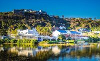
'''North New Gough Island Wildlands''' is a district in New Gough Island. It is the largely a rural and nature filled area in the country. It is home to the North New Gough Island | '''North New Gough Island Wildlands''' is a district in [[New Gough Island]]. It is the largely a rural and nature filled area in the country. It is home to the North New Gough Island National Forest and Park. There are 5 neighborhoods in the district: Bohemian Bay, Forest Village, North Wildlands Rural Area, South Wildlands Rural Area, and North Cape Village. | ||
==Neighborhoods== | ==Neighborhoods== | ||
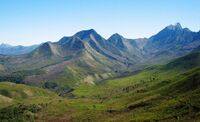
The most populated neighborhood in the North New Gough Island Wildlands is Bohemian Bay located on the west side of the island. The Forest Village is located on the south side of the island by The New Gough Island Strait Bridge. While the North Cape Village is located on the northern most part of the island, and thus the northern most point of the country. The North and South Wildlands Rural Areas area rural areas that are heavily forested and mountainous. The North New Gough Island National Park and Forest is in both neighborhoods. It takes up, 100 sq mi (260 sq km) in area. It is home to the tallest mountain in the country, Mount Blandan which is 5,789 feet (1,764.5 meters) tall. | |||
{| class="wikitable sortable" | |||
|+ Neighborhoods of North New Gough Island Wildlands | |||
|- | |||
! Neighborhood !! Population !! Land Area || Population Density | |||
|- | |||
| Bohemian Bay || 18,000 || {{convert|3|sqmi|km2|abbr=on}} || 6,000 people per sq mi (2,307.7 people per sq km) | |||
|- | |||
| Forest Village || 12,000 || {{convert|10|sqmi|km2|abbr=on}} || 1,200 people per sq mi (461.5 people per sq km) | |||
|- | |||
| North Cape Village || 3,000 || {{convert|2|sqmi|km2|abbr=on}} || 1,500 people per sq mi (576.9 people per sq km) | |||
|- | |||
| North Wildlands Rural Area || 10,000 || {{convert|694.55|sqmi|km2|abbr=on}} || 14.4 people per sq mi (5.6 people per sq km) | |||
|- | |||
| South Wildlands Rural Area || 20,000 || {{convert|644|sqmi|km2|abbr=on}} || 31.1 people per sq mi (12 people per sq km) | |||
|} | |||
==Climate== | |||
The climate of North New Gough Island is mostly highland subtropical to tropical under the influence of a marine monsoon. It is the rainiest place in the country. The island also has the coldest temperatures recorded in the country. Despite being north of South New Gough Island, it has a cooler wetter climate because of the forest cover and mountainous terrain. | |||
{{Weather box | |||
| name = Weather | |||
| width = <!-- Width parameter for wikitable, default width=100%. Set width=auto to fit the table in the next available space automatically. --> | |||
| collapsed = <!-- Any entry in this line will make the template initially collapsed. Leave blank or remove this line for uncollapsed. --> | |||
| open = <!-- Any entry in this line will make the template permanently open, and remove the hide button. Remove this line for a collapsible table. --> | |||
| single line = / | |||
| trace = <!-- Any entry in this line will replace the word "trace" with the input when entering trace amounts for precipitation. Leave blank for default.--> | |||
| location = Mount Blandan, North New Gough Island National Forest and Park, North New Gough Island Wildlands, New Gough Island | |||
| temperature colour = <!-- Enter "pastel" for pastel temperature colours, "none" for no colours, remove this line for the standard colouring. --> | |||
| Jan record high F = 82 | |||
| Feb record high F = 82 | |||
| Mar record high F = 81 | |||
| Apr record high F = 79 | |||
| May record high F = 73 | |||
| Jun record high F = 70 | |||
| Jul record high F = 72 | |||
| Aug record high F = 77 | |||
| Sep record high F = 86 | |||
| Oct record high F = 89 | |||
| Nov record high F = 90 | |||
| Dec record high F = 88 | |||
| year record high F = | |||
<!-- Average monthly absolute maximum temperatures (that is, on average, the highest temperature to be observed in a month). It is important to note that this data is not very prominent in most climate data archives. --> | |||
<!-- Average high temperatures --> | |||
| Jan high F = 71.3 | |||
| Feb high F = 70.4 | |||
| Mar high F = 68.9 | |||
| Apr high F = 65.6 | |||
| May high F = 62.3 | |||
| Jun high F = 59.0 | |||
| Jul high F = 60.8 | |||
| Aug high F = 64.1 | |||
| Sep high F = 72.2 | |||
| Oct high F = 77.2 | |||
| Nov high F = 78.4 | |||
| Dec high F = 74.6 | |||
| year high F = | |||
<!-- Mean daily temperature --> | |||
| Jan mean F = 65.2 | |||
| Feb mean F = 64.3 | |||
| Mar mean F = 62.5 | |||
| Apr mean F = 59.3 | |||
| May mean F = 55.2 | |||
| Jun mean F = 51.9 | |||
| Jul mean F = 53.2 | |||
| Aug mean F = 57.1 | |||
| Sep mean F = 63.2 | |||
| Oct mean F = 67.4 | |||
| Nov mean F = 69.8 | |||
| Dec mean F = 67.7 | |||
| year mean F = | |||
<!-- Average low temperatures --> | |||
| Jan low F = 59.0 | |||
| Feb low F = 58.1 | |||
| Mar low F = 56.1 | |||
| Apr low F = 52.9 | |||
| May low F = 48.1 | |||
| Jun low F = 44.8 | |||
| Jul low F = 45.6 | |||
| Aug low F = 50.1 | |||
| Sep low F = 54.2 | |||
| Oct low F = 57.5 | |||
| Nov low F = 61.2 | |||
| Dec low F = 60.8 | |||
| year low F = | |||
<!-- Average monthly absolute minimum temperatures (that is, on average, the lowest temperature to be observed in a month). It is important to note that this data is not very prominent in most climate data archives. --> | |||
<!-- Record low temperatures --> | |||
<!-- Note that record temperatures should only be used when the data period is of the greatest length possible. --> | |||
| Jan record low F = 47 | |||
| Feb record low F = 44 | |||
| Mar record low F = 41 | |||
| Apr record low F = 36 | |||
| May record low F = 32 | |||
| Jun record low F = 30 | |||
| Jul record low F = 34 | |||
| Aug record low F = 39 | |||
| Sep record low F = 45 | |||
| Oct record low F = 50 | |||
| Nov record low F = 53 | |||
| Dec record low F = 50 | |||
| year record low F = | |||
<!-- Rainfall --> | |||
| rain colour = green | |||
| Jan rain inch = 20.1 | |||
| Feb rain inch = 22.1 | |||
| Mar rain inch = 18.4 | |||
| Apr rain inch = 12.1 | |||
| May rain inch = 5.8 | |||
| Jun rain inch = 4.1 | |||
| Jul rain inch = 2.4 | |||
| Aug rain inch = 4.8 | |||
| Sep rain inch = 5.2 | |||
| Oct rain inch = 5.9 | |||
| Nov rain inch = 7.1 | |||
| Dec rain inch = 14.8 | |||
| year rain inch = | |||
<!-- Average number of rainy days --> | |||
| unit rain days = 0.1 | |||
| Jan rain days = 20 | |||
| Feb rain days = 22 | |||
| Mar rain days = 18 | |||
| Apr rain days = 14 | |||
| May rain days = 10 | |||
| Jun rain days = 7 | |||
| Jul rain days = 3 | |||
| Aug rain days = 4 | |||
| Sep rain days = 5 | |||
| Oct rain days = 8 | |||
| Nov rain days = 10 | |||
| Dec rain days = 16 | |||
| year rain days = | |||
| source = New Gough Island Weather Service | |||
}} | |||
{{Weather box | |||
| name = Weather | |||
| width = <!-- Width parameter for wikitable, default width=100%. Set width=auto to fit the table in the next available space automatically. --> | |||
| collapsed = <!-- Any entry in this line will make the template initially collapsed. Leave blank or remove this line for uncollapsed. --> | |||
| open = <!-- Any entry in this line will make the template permanently open, and remove the hide button. Remove this line for a collapsible table. --> | |||
| single line = / | |||
| trace = <!-- Any entry in this line will replace the word "trace" with the input when entering trace amounts for precipitation. Leave blank for default.--> | |||
| location = Bohemian Bay, North New Gough Island Wildlands, New Gough Island | |||
| temperature colour = <!-- Enter "pastel" for pastel temperature colours, "none" for no colours, remove this line for the standard colouring. --> | |||
| Jan record high F = 90 | |||
| Feb record high F = 88 | |||
| Mar record high F = 86 | |||
| Apr record high F = 83 | |||
| May record high F = 81 | |||
| Jun record high F = 77 | |||
| Jul record high F = 80 | |||
| Aug record high F = 86 | |||
| Sep record high F = 92 | |||
| Oct record high F = 97 | |||
| Nov record high F = 101 | |||
| Dec record high F = 98 | |||
| year record high F = | |||
<!-- Average monthly absolute maximum temperatures (that is, on average, the highest temperature to be observed in a month). It is important to note that this data is not very prominent in most climate data archives. --> | |||
<!-- Average high temperatures --> | |||
| Jan high F = 78.1 | |||
| Feb high F = 76.8 | |||
| Mar high F = 75.8 | |||
| Apr high F = 72.4 | |||
| May high F = 68.1 | |||
| Jun high F = 65.8 | |||
| Jul high F = 69.1 | |||
| Aug high F = 74.1 | |||
| Sep high F = 78.1 | |||
| Oct high F = 82.9 | |||
| Nov high F = 84.1 | |||
| Dec high F = 80.9 | |||
| year high F = | |||
<!-- Mean daily temperature --> | |||
| Jan mean F = 73.6 | |||
| Feb mean F = 72.5 | |||
| Mar mean F = 71.0 | |||
| Apr mean F = 67.7 | |||
| May mean F = 63.1 | |||
| Jun mean F = 60.3 | |||
| Jul mean F = 62.4 | |||
| Aug mean F = 67.1 | |||
| Sep mean F = 71.2 | |||
| Oct mean F = 75.2 | |||
| Nov mean F = 77.7 | |||
| Dec mean F = 75.9 | |||
| year mean F = | |||
<!-- Average low temperatures --> | |||
| Jan low F = 69.0 | |||
| Feb low F = 68.1 | |||
| Mar low F = 66.1 | |||
| Apr low F = 62.9 | |||
| May low F = 58.1 | |||
| Jun low F = 54.8 | |||
| Jul low F = 55.6 | |||
| Aug low F = 60.1 | |||
| Sep low F = 64.2 | |||
| Oct low F = 67.5 | |||
| Nov low F = 71.2 | |||
| Dec low F = 70.8 | |||
| year low F = | |||
<!-- Average monthly absolute minimum temperatures (that is, on average, the lowest temperature to be observed in a month). It is important to note that this data is not very prominent in most climate data archives. --> | |||
<!-- Record low temperatures --> | |||
<!-- Note that record temperatures should only be used when the data period is of the greatest length possible. --> | |||
| Jan record low F = 57 | |||
| Feb record low F = 54 | |||
| Mar record low F = 51 | |||
| Apr record low F = 46 | |||
| May record low F = 42 | |||
| Jun record low F = 40 | |||
| Jul record low F = 44 | |||
| Aug record low F = 49 | |||
| Sep record low F = 55 | |||
| Oct record low F = 60 | |||
| Nov record low F = 63 | |||
| Dec record low F = 60 | |||
| year record low F = | |||
<!-- Rainfall --> | |||
| rain colour = green | |||
| Jan rain inch = 15.1 | |||
| Feb rain inch = 18.1 | |||
| Mar rain inch = 12.4 | |||
| Apr rain inch = 8.1 | |||
| May rain inch = 6.8 | |||
| Jun rain inch = 4.1 | |||
| Jul rain inch = 3.4 | |||
| Aug rain inch = 5.8 | |||
| Sep rain inch = 6.2 | |||
| Oct rain inch = 6.9 | |||
| Nov rain inch = 10.1 | |||
| Dec rain inch = 13.8 | |||
| year rain inch = | |||
<!-- Average number of rainy days --> | |||
| unit rain days = 0.1 | |||
| Jan rain days = 20 | |||
| Feb rain days = 22 | |||
| Mar rain days = 18 | |||
| Apr rain days = 14 | |||
| May rain days = 10 | |||
| Jun rain days = 9 | |||
| Jul rain days = 5 | |||
| Aug rain days = 6 | |||
| Sep rain days = 8 | |||
| Oct rain days = 10 | |||
| Nov rain days = 11 | |||
| Dec rain days = 16 | |||
| year rain days = | |||
| source = New Gough Island Weather Service | |||
}} | |||
{{Template:Anteria info pages}} | {{Template:Anteria info pages}} | ||
[[Category:Anteria]] | [[Category:Anteria]] | ||
[[Category:New Gough Island]] | [[Category:New Gough Island]] | ||
[[Category:Countries in Anteria]] | [[Category:Countries in Anteria]] | ||
Latest revision as of 17:22, 5 May 2024
North New Gough Island Wildlands | |
|---|---|
District | |
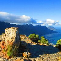
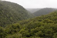
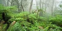
From top to bottom: Bohemian Bay, Forest Village, Mount Blandan, Mountains Along the Sea, Subtropical highland forest, cloud forest | |
| Country | New Gough Island |
| District | North New Gough Island Wildlands |
| Government | |
| • District Administrator | Jake Maine (WFP) |
| Area | |
| • District | 1,353.55 sq mi (3,505.7 km2) |
| • Land | 1,353.55 sq mi (3,505.7 km2) |
| • Urban | 15 sq mi (40 km2) |
| • Rural | 1,338.55 sq mi (3,466.8 km2) |
| Population (2024) | |
| • District | 63,000 |
| • Density | 46.5/sq mi (18.0/km2) |
| • Urban | 33,000 |
| • Urban density | 2,200/sq mi (800/km2) |
| • Rural | 30,000 |
| • Rural density | 22.4/sq mi (8.6/km2) |
| Demonym | North Wildlander |
North New Gough Island Wildlands is a district in New Gough Island. It is the largely a rural and nature filled area in the country. It is home to the North New Gough Island National Forest and Park. There are 5 neighborhoods in the district: Bohemian Bay, Forest Village, North Wildlands Rural Area, South Wildlands Rural Area, and North Cape Village.
Neighborhoods
The most populated neighborhood in the North New Gough Island Wildlands is Bohemian Bay located on the west side of the island. The Forest Village is located on the south side of the island by The New Gough Island Strait Bridge. While the North Cape Village is located on the northern most part of the island, and thus the northern most point of the country. The North and South Wildlands Rural Areas area rural areas that are heavily forested and mountainous. The North New Gough Island National Park and Forest is in both neighborhoods. It takes up, 100 sq mi (260 sq km) in area. It is home to the tallest mountain in the country, Mount Blandan which is 5,789 feet (1,764.5 meters) tall.
| Neighborhood | Population | Land Area | Population Density |
|---|---|---|---|
| Bohemian Bay | 18,000 | 3 sq mi (7.8 km2) | 6,000 people per sq mi (2,307.7 people per sq km) |
| Forest Village | 12,000 | 10 sq mi (26 km2) | 1,200 people per sq mi (461.5 people per sq km) |
| North Cape Village | 3,000 | 2 sq mi (5.2 km2) | 1,500 people per sq mi (576.9 people per sq km) |
| North Wildlands Rural Area | 10,000 | 694.55 sq mi (1,798.9 km2) | 14.4 people per sq mi (5.6 people per sq km) |
| South Wildlands Rural Area | 20,000 | 644 sq mi (1,670 km2) | 31.1 people per sq mi (12 people per sq km) |
Climate
The climate of North New Gough Island is mostly highland subtropical to tropical under the influence of a marine monsoon. It is the rainiest place in the country. The island also has the coldest temperatures recorded in the country. Despite being north of South New Gough Island, it has a cooler wetter climate because of the forest cover and mountainous terrain.
| Month | Jan | Feb | Mar | Apr | May | Jun | Jul | Aug | Sep | Oct | Nov | Dec | Year |
|---|---|---|---|---|---|---|---|---|---|---|---|---|---|
| Record high °F (°C) | 82 (28) |
82 (28) |
81 (27) |
79 (26) |
73 (23) |
70 (21) |
72 (22) |
77 (25) |
86 (30) |
89 (32) |
90 (32) |
88 (31) |
90 (32) |
| Average high °F (°C) | 71.3 (21.8) |
70.4 (21.3) |
68.9 (20.5) |
65.6 (18.7) |
62.3 (16.8) |
59.0 (15.0) |
60.8 (16.0) |
64.1 (17.8) |
72.2 (22.3) |
77.2 (25.1) |
78.4 (25.8) |
74.6 (23.7) |
68.7 (20.4) |
| Daily mean °F (°C) | 65.2 (18.4) |
64.3 (17.9) |
62.5 (16.9) |
59.3 (15.2) |
55.2 (12.9) |
51.9 (11.1) |
53.2 (11.8) |
57.1 (13.9) |
63.2 (17.3) |
67.4 (19.7) |
69.8 (21.0) |
67.7 (19.8) |
61.4 (16.3) |
| Average low °F (°C) | 59.0 (15.0) |
58.1 (14.5) |
56.1 (13.4) |
52.9 (11.6) |
48.1 (8.9) |
44.8 (7.1) |
45.6 (7.6) |
50.1 (10.1) |
54.2 (12.3) |
57.5 (14.2) |
61.2 (16.2) |
60.8 (16.0) |
54.0 (12.2) |
| Record low °F (°C) | 47 (8) |
44 (7) |
41 (5) |
36 (2) |
32 (0) |
30 (−1) |
34 (1) |
39 (4) |
45 (7) |
50 (10) |
53 (12) |
50 (10) |
30 (−1) |
| Average rainfall inches (mm) | 20.1 (510) |
22.1 (560) |
18.4 (470) |
12.1 (310) |
5.8 (150) |
4.1 (100) |
2.4 (61) |
4.8 (120) |
5.2 (130) |
5.9 (150) |
7.1 (180) |
14.8 (380) |
122.8 (3,121) |
| Average rainy days (≥ 0.1) | 20 | 22 | 18 | 14 | 10 | 7 | 3 | 4 | 5 | 8 | 10 | 16 | 137 |
| Source: New Gough Island Weather Service | |||||||||||||
| Month | Jan | Feb | Mar | Apr | May | Jun | Jul | Aug | Sep | Oct | Nov | Dec | Year |
|---|---|---|---|---|---|---|---|---|---|---|---|---|---|
| Record high °F (°C) | 90 (32) |
88 (31) |
86 (30) |
83 (28) |
81 (27) |
77 (25) |
80 (27) |
86 (30) |
92 (33) |
97 (36) |
101 (38) |
98 (37) |
101 (38) |
| Average high °F (°C) | 78.1 (25.6) |
76.8 (24.9) |
75.8 (24.3) |
72.4 (22.4) |
68.1 (20.1) |
65.8 (18.8) |
69.1 (20.6) |
74.1 (23.4) |
78.1 (25.6) |
82.9 (28.3) |
84.1 (28.9) |
80.9 (27.2) |
75.5 (24.2) |
| Daily mean °F (°C) | 73.6 (23.1) |
72.5 (22.5) |
71.0 (21.7) |
67.7 (19.8) |
63.1 (17.3) |
60.3 (15.7) |
62.4 (16.9) |
67.1 (19.5) |
71.2 (21.8) |
75.2 (24.0) |
77.7 (25.4) |
75.9 (24.4) |
69.8 (21.0) |
| Average low °F (°C) | 69.0 (20.6) |
68.1 (20.1) |
66.1 (18.9) |
62.9 (17.2) |
58.1 (14.5) |
54.8 (12.7) |
55.6 (13.1) |
60.1 (15.6) |
64.2 (17.9) |
67.5 (19.7) |
71.2 (21.8) |
70.8 (21.6) |
64.0 (17.8) |
| Record low °F (°C) | 57 (14) |
54 (12) |
51 (11) |
46 (8) |
42 (6) |
40 (4) |
44 (7) |
49 (9) |
55 (13) |
60 (16) |
63 (17) |
60 (16) |
40 (4) |
| Average rainfall inches (mm) | 15.1 (380) |
18.1 (460) |
12.4 (310) |
8.1 (210) |
6.8 (170) |
4.1 (100) |
3.4 (86) |
5.8 (150) |
6.2 (160) |
6.9 (180) |
10.1 (260) |
13.8 (350) |
110.8 (2,816) |
| Average rainy days (≥ 0.1) | 20 | 22 | 18 | 14 | 10 | 9 | 5 | 6 | 8 | 10 | 11 | 16 | 149 |
| Source: New Gough Island Weather Service | |||||||||||||

