Greycott: Difference between revisions
No edit summary |
|||
| (4 intermediate revisions by the same user not shown) | |||
| Line 80: | Line 80: | ||
|subdivision_name = [[New Gough Island]] | |subdivision_name = [[New Gough Island]] | ||
|subdivision_type1 = Region | |subdivision_type1 = Region | ||
|subdivision_name1 = | |subdivision_name1 = South East Islands | ||
|subdivision_type2 = Municipality | |subdivision_type2 = Municipality | ||
|subdivision_name2 = [[Greycott|Hartridge]] | |subdivision_name2 = [[Greycott|Hartridge]] | ||
| Line 131: | Line 131: | ||
|population_footnotes = | |population_footnotes = | ||
|population_as_of = 2024 | |population_as_of = 2024 | ||
|population_total = | |population_total = 438,000 | ||
|population_density_sq_mi = | |population_density_sq_mi = 8,760 | ||
|population_urban = | |population_urban = 1,160,000 | ||
|population_density_urban_sq_mi = | |population_density_urban_sq_mi = 1,671 | ||
|population_metro = 1, | |population_metro = 1,628,000 | ||
|population_density_metro_sq_mi = | |population_density_metro_sq_mi = 463 | ||
|population_note = | |population_note = | ||
|population_demonym = Hartridger | |population_demonym = Hartridger | ||
| Line 156: | Line 156: | ||
==History== | ==History== | ||
==Geography== | ==Geography== | ||
The Greater Hartridge Area is located in the Hartridge Forest Plain, sandwiched between the | The Greater Hartridge Area is located in the Hartridge Forest Plain, sandwiched between the Island Coastal Ranges. The forest costal plain isn't flat but quite hilly. The Hartridge Bay is at its widest point 1.5 miles (7,920 feet or 2,414 meters) at its narrowest. The tallest mountain in the Greater Hartridge Area is Mount Baylee which is 5,612 feet (1,710.5 meters) tall. Hartridge is located on the Hartridge Península while it's twin city, Gough City is on the shore. | ||
===Climate=== | ===Climate=== | ||
The climate of Hartridge is | The climate of Hartridge is Oceanic. With cool to mild conditions all year round. During the summer it is warm to hot and less rainy. Temperatures decline in the autumn and the frequency of the rain increases. Snow can occur during the months of June through August. Though heavy long-lasting snow is uncommon. Cold waves are common with temperatures reaching 3 degrees F (-16 degrees C) on July 15, 2012. The heaviest snowstorm happened on July 14, 2012 when it brought 6.8 in (17 cm) of snow. The coldest high temperature ever recorded was 16 degrees F (-9 degrees C) on July 15, 2012. The wet cool spring gives way to summer when heatwaves can take place. With the hottest temperature ever recorded was 101 degrees F (38 degrees C) on January 2, 1997, the warmest overnight temperature was 77 degrees F (25 degrees C) on January 15, 2014. While the city receives a moderate of rainfall through the year, the rainiest year was 1984 with 100 in (2,540 mm) while the driest year was 1990 with 30 in (762 mm). The wettest month was July 1999 with 13 in (330 mm). The wettest day was August 4, 1955 when 5 in (127 mm) of rain fell in 24 hours. The direst month was January 1990 with only 0.9 in (23 mm) rain fell. The snowiest month was July 2012 with 14.1 in (36 cm) of snow fell. The snowiest season was in 1996 with 24 in (61 cm) of snow. | ||
{{Weather box | {{Weather box | ||
| name = Weather | | name = Weather | ||
| Line 166: | Line 166: | ||
| single line = / | | single line = / | ||
| trace = <!-- Any entry in this line will replace the word "trace" with the input when entering trace amounts for precipitation. Leave blank for default.--> | | trace = <!-- Any entry in this line will replace the word "trace" with the input when entering trace amounts for precipitation. Leave blank for default.--> | ||
| location = Hartridge, South | | location = Hartridge, South East Islands Region, New Gough Island | ||
| temperature colour = <!-- Enter "pastel" for pastel temperature colours, "none" for no colours, remove this line for the standard colouring. --> | | temperature colour = <!-- Enter "pastel" for pastel temperature colours, "none" for no colours, remove this line for the standard colouring. --> | ||
| Jan record high F = | | Jan record high F = 101 | ||
| Feb record high F = | | Feb record high F = 99 | ||
| Mar record high F = 95 | | Mar record high F = 95 | ||
| Apr record high F = 86 | | Apr record high F = 86 | ||
| Line 179: | Line 179: | ||
| Oct record high F = 95 | | Oct record high F = 95 | ||
| Nov record high F = 99 | | Nov record high F = 99 | ||
| Dec record high F = | | Dec record high F = 100 | ||
| year record high F = | | year record high F = | ||
<!-- Average monthly absolute maximum temperatures (that is, on average, the highest temperature to be observed in a month). It is important to note that this data is not very prominent in most climate data archives. --> | <!-- Average monthly absolute maximum temperatures (that is, on average, the highest temperature to be observed in a month). It is important to note that this data is not very prominent in most climate data archives. --> | ||
<!-- Average high temperatures --> | <!-- Average high temperatures --> | ||
| Jan high F = | | Jan high F = 77 | ||
| Feb high F = | | Feb high F = 74 | ||
| Mar high F = | | Mar high F = 67 | ||
| Apr high F = | | Apr high F = 61 | ||
| May high F = | | May high F = 55 | ||
| Jun high F = | | Jun high F = 50 | ||
| Jul high F = | | Jul high F = 47 | ||
| Aug high F = | | Aug high F = 48 | ||
| Sep high F = | | Sep high F = 52 | ||
| Oct high F = | | Oct high F = 60 | ||
| Nov high F = | | Nov high F = 68 | ||
| Dec high F = | | Dec high F = 73 | ||
| year high F = | | year high F = | ||
<!-- Mean daily temperature --> | <!-- Mean daily temperature --> | ||
| Line 211: | Line 211: | ||
| year mean F = | | year mean F = | ||
<!-- Average low temperatures --> | <!-- Average low temperatures --> | ||
| Jan low F = | | Jan low F = 60 | ||
| Feb low F = | | Feb low F = 58 | ||
| Mar low F = | | Mar low F = 50 | ||
| Apr low F = | | Apr low F = 44 | ||
| May low F = | | May low F = 38 | ||
| Jun low F = | | Jun low F = 32 | ||
| Jul low F = | | Jul low F = 27 | ||
| Aug low F = | | Aug low F = 28 | ||
| Sep low F = | | Sep low F = 33 | ||
| Oct low F = | | Oct low F = 39 | ||
| Nov low F = | | Nov low F = 45 | ||
| Dec low F = | | Dec low F = 52 | ||
| year low F = | | year low F = | ||
<!-- Average monthly absolute minimum temperatures (that is, on average, the lowest temperature to be observed in a month). It is important to note that this data is not very prominent in most climate data archives. --> | <!-- Average monthly absolute minimum temperatures (that is, on average, the lowest temperature to be observed in a month). It is important to note that this data is not very prominent in most climate data archives. --> | ||
<!-- Record low temperatures --> | <!-- Record low temperatures --> | ||
<!-- Note that record temperatures should only be used when the data period is of the greatest length possible. --> | <!-- Note that record temperatures should only be used when the data period is of the greatest length possible. --> | ||
| Jan record low F = | | Jan record low F = 45 | ||
| Feb record low F = | | Feb record low F = 42 | ||
| Mar record low F = | | Mar record low F = 34 | ||
| Apr record low F = | | Apr record low F = 27 | ||
| May record low F = | | May record low F = 21 | ||
| Jun record low F = | | Jun record low F = 11 | ||
| Jul record low F = | | Jul record low F = 3 | ||
| Aug record low F = | | Aug record low F = 4 | ||
| Sep record low F = | | Sep record low F = 14 | ||
| Oct record low F = | | Oct record low F = 25 | ||
| Nov record low F = | | Nov record low F = 32 | ||
| Dec record low F = | | Dec record low F = 41 | ||
| year record low F = | | year record low F = | ||
<!-- Rainfall --> | <!-- Rainfall --> | ||
| rain colour = green | | rain colour = green | ||
| Jan rain inch = | | Jan rain inch = 3.4 | ||
| Feb rain inch = | | Feb rain inch = 3.9 | ||
| Mar rain inch = | | Mar rain inch = 4.3 | ||
| Apr rain inch = | | Apr rain inch = 4.8 | ||
| May rain inch = | | May rain inch = 5.4 | ||
| Jun rain inch = | | Jun rain inch = 6.3 | ||
| Jul rain inch = | | Jul rain inch = 6.8 | ||
| Aug rain inch = | | Aug rain inch = 6.5 | ||
| Sep rain inch = | | Sep rain inch = 5.7 | ||
| Oct rain inch = | | Oct rain inch = 4.8 | ||
| Nov rain inch = | | Nov rain inch = 4.2 | ||
| Dec rain inch = | | Dec rain inch = 3.8 | ||
| year rain inch = | | year rain inch = | ||
<!-- Average number of rainy days --> | <!-- Average number of rainy days --> | ||
| Line 300: | Line 300: | ||
===Bus and Bus Rapid Transit=== | ===Bus and Bus Rapid Transit=== | ||
There are 130 bus routes serving the Greater Hartridge Area. There are | There are 130 bus routes serving the Greater Hartridge Area. There are 50 Hartridge city routes and 70 outer city routes. There are 5 bus rapid transit routes and 5 express routes. | ||
===Taxis and Ride-sharing=== | ===Taxis and Ride-sharing=== | ||
There are an estimated 5,000 taxis throughout the Greater Hartridge Area. Popular ridesharing services such as Go Places! or Wayride are the alternative to taxis. Rideshares can go areas where taxis can't such as out of the Greater Hartridge Urban Area. And are usually much cheaper than taxis. | There are an estimated 5,000 taxis throughout the Greater Hartridge Area. Popular ridesharing services such as Go Places! or Wayride are the alternative to taxis. Rideshares can go areas where taxis can't such as out of the Greater Hartridge Urban Area. And are usually much cheaper than taxis. | ||
===Motorways=== | ===Motorways=== | ||
There are 3 motorways within the Hartridge city limits, the Northside Motorway and the West Wilderness Motorway would merge into the Hartridge City Motorway at the Paramount Interchange. The Hartridge City Motorway stretches for 4.92 miles (8 km) into Uptown Hartridge ending at the intersection of Queen Street and Royal Main Ave. The Bypass Ring Motorway is a horseshoe shaped motorway | There are 3 motorways within the Hartridge city limits, the Northside Motorway and the West Wilderness Motorway would merge into the Hartridge City Motorway at the Paramount Interchange. The Hartridge City Motorway stretches for 4.92 miles (8 km) into Uptown Hartridge ending at the intersection of Queen Street and Royal Main Ave. The Bypass Ring Motorway is a horseshoe shaped motorway for Hartridge. It stretches for 30 miles (50 km). The Bypass Ring Motorway connects to the Eastshore Motorway. | ||
<gallery> | <gallery> | ||
NZ-New Gough Island Images 8.jpg|Northside Motorway | NZ-New Gough Island Images 8.jpg|Northside Motorway | ||
New Gough Island Motorway.jpg|Hartridge City Motorwway | New Gough Island Motorway.jpg|Hartridge City Motorwway | ||
</gallery> | </gallery> | ||
===Commuter Rail=== | ===Commuter Rail=== | ||
Latest revision as of 16:49, 20 July 2024
Hartridge | |
|---|---|
City | |
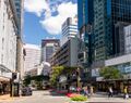
             From left to right,down: Hatridege city skyline from the Southern Coastal Ranges, Hartridge city skyline seen from across the Hartridge Bay, Commerce Street in Downtown Hartridge, Hartridge city skyline, Harridge City Panorama, Wellington Street in Downtown Hartridge, Victoria Hills neighborhood, Miramar neighborhood, Hartridge University, Eastern Town neighborhood, Hartridge Art Gallery, Hartridge Old Trust Building, Hartridge City Hall, Hartridge Bay Bridge (opened 1929) | |
| Country | New Gough Island |
| Region | South East Islands |
| Municipality | Hartridge |
| Government | |
| • Mayor | Lisa Haddock (LDP) |
| Area | |
| • City | 75 sq mi (190 km2) |
| • Land | 50 sq mi (100 km2) |
| • Water | 25 sq mi (60 km2) |
| • Urban | 694 sq mi (1,800 km2) |
| • Metro | 3,515 sq mi (9,100 km2) |
| Population (2024) | |
| • City | 438,000 |
| • Density | 8,760/sq mi (3,380/km2) |
| • Urban | 1,160,000 |
| • Urban density | 1,671/sq mi (645/km2) |
| • Metro | 1,628,000 |
| • Metro density | 463/sq mi (179/km2) |
| Demonym | Hartridger |
Hartridge is a city in New Gough Island. It is the largest city in the country, home to 438,000 people as of 2024. The Greater Hartridge Area is home to 1.02 million people in the North Coast Region. The Greater Hartridge area takes up 77% of the region's population in 33% of the region's area. On the national scale the area takes up 35% of the population in 2.6% of the national land area. Other cities in the area include the capital of South Peninsula Region, Gough City which is across the river from Hartridge. And the country's 8th largest city and suburb of Hartridge, Berman. The city is cosmopolitan for its size. It is the financial and banking center of the country. It is home to the tallest building in the country, the Majestic Center Tower which is 55 Storeys and 771 feet (235 meters) tall. The city is home to the majority of the national and international corporations in the country and the Hartridge Stock Market. It is also home to the New Gough Island National Art Gallery, the most prestigious university in the country, Hartridge University. The city is famous for its Victorian, Edwardian, Neoclassical, and Modern architecture styles.
History
Geography
The Greater Hartridge Area is located in the Hartridge Forest Plain, sandwiched between the Island Coastal Ranges. The forest costal plain isn't flat but quite hilly. The Hartridge Bay is at its widest point 1.5 miles (7,920 feet or 2,414 meters) at its narrowest. The tallest mountain in the Greater Hartridge Area is Mount Baylee which is 5,612 feet (1,710.5 meters) tall. Hartridge is located on the Hartridge Península while it's twin city, Gough City is on the shore.
Climate
The climate of Hartridge is Oceanic. With cool to mild conditions all year round. During the summer it is warm to hot and less rainy. Temperatures decline in the autumn and the frequency of the rain increases. Snow can occur during the months of June through August. Though heavy long-lasting snow is uncommon. Cold waves are common with temperatures reaching 3 degrees F (-16 degrees C) on July 15, 2012. The heaviest snowstorm happened on July 14, 2012 when it brought 6.8 in (17 cm) of snow. The coldest high temperature ever recorded was 16 degrees F (-9 degrees C) on July 15, 2012. The wet cool spring gives way to summer when heatwaves can take place. With the hottest temperature ever recorded was 101 degrees F (38 degrees C) on January 2, 1997, the warmest overnight temperature was 77 degrees F (25 degrees C) on January 15, 2014. While the city receives a moderate of rainfall through the year, the rainiest year was 1984 with 100 in (2,540 mm) while the driest year was 1990 with 30 in (762 mm). The wettest month was July 1999 with 13 in (330 mm). The wettest day was August 4, 1955 when 5 in (127 mm) of rain fell in 24 hours. The direst month was January 1990 with only 0.9 in (23 mm) rain fell. The snowiest month was July 2012 with 14.1 in (36 cm) of snow fell. The snowiest season was in 1996 with 24 in (61 cm) of snow.
| Month | Jan | Feb | Mar | Apr | May | Jun | Jul | Aug | Sep | Oct | Nov | Dec | Year |
|---|---|---|---|---|---|---|---|---|---|---|---|---|---|
| Record high °F (°C) | 101 (38) |
99 (37) |
95 (35) |
86 (30) |
80 (27) |
77 (25) |
72 (22) |
77 (25) |
92 (33) |
95 (35) |
99 (37) |
100 (38) |
101 (38) |
| Average high °F (°C) | 77 (25) |
74 (23) |
67 (19) |
61 (16) |
55 (13) |
50 (10) |
47 (8) |
48 (9) |
52 (11) |
60 (16) |
68 (20) |
73 (23) |
61 (16) |
| Average low °F (°C) | 60 (16) |
58 (14) |
50 (10) |
44 (7) |
38 (3) |
32 (0) |
27 (−3) |
28 (−2) |
33 (1) |
39 (4) |
45 (7) |
52 (11) |
42 (6) |
| Record low °F (°C) | 45 (7) |
42 (6) |
34 (1) |
27 (−3) |
21 (−6) |
11 (−12) |
3 (−16) |
4 (−16) |
14 (−10) |
25 (−4) |
32 (0) |
41 (5) |
3 (−16) |
| Average rainfall inches (mm) | 3.4 (86) |
3.9 (99) |
4.3 (110) |
4.8 (120) |
5.4 (140) |
6.3 (160) |
6.8 (170) |
6.5 (170) |
5.7 (140) |
4.8 (120) |
4.2 (110) |
3.8 (97) |
59.9 (1,522) |
| Average rainy days (≥ 0.1) | 7 | 7 | 8 | 9 | 10 | 12 | 14 | 14 | 12 | 10 | 9 | 8 | 120 |
| Source: New Gough Island Weather Service | |||||||||||||
Neighborhoods
Downtown Hartridge
Eastern Town
Miramar
Uptown Hartridge
East Town
Victorian Hills
Star Hill
Greycott
Transportation
Transportation of Hartridge and Greater Hartridge is primarily done by private vehicle. However, there is a public transportation authority.
Streets
Royal Main Ave

Quray Court

Westford Street


Bus and Bus Rapid Transit
There are 130 bus routes serving the Greater Hartridge Area. There are 50 Hartridge city routes and 70 outer city routes. There are 5 bus rapid transit routes and 5 express routes.
Taxis and Ride-sharing
There are an estimated 5,000 taxis throughout the Greater Hartridge Area. Popular ridesharing services such as Go Places! or Wayride are the alternative to taxis. Rideshares can go areas where taxis can't such as out of the Greater Hartridge Urban Area. And are usually much cheaper than taxis.
Motorways
There are 3 motorways within the Hartridge city limits, the Northside Motorway and the West Wilderness Motorway would merge into the Hartridge City Motorway at the Paramount Interchange. The Hartridge City Motorway stretches for 4.92 miles (8 km) into Uptown Hartridge ending at the intersection of Queen Street and Royal Main Ave. The Bypass Ring Motorway is a horseshoe shaped motorway for Hartridge. It stretches for 30 miles (50 km). The Bypass Ring Motorway connects to the Eastshore Motorway.

Northside Motorway

Hartridge City Motorwway


Commuter Rail
Rail and Airport
Currently, there are 950 pages associated to Anteria | |||||||||||
| History |
| ||||||||||
| Legal status of | |||||||||||
| Culture | |||||||||||
| Society and Demographics | |||||||||||
| Economics | |||||||||||
| Geography |
| ||||||||||
| Government | |||||||||||
| International organizations |
| ||||||||||
| Sporting Unions | |||||||||||