Gallatin: Difference between revisions
No edit summary |
No edit summary |
||
| Line 6: | Line 6: | ||
|image_skyline = | |image_skyline = | ||
{{Photomontage | {{Photomontage | ||
| photo1a = | | photo1a = Gallatin CBD.jpg | ||
| photo1b = | | photo1b = | ||
| photo1c = | | photo1c = | ||
| photo1d = | | photo1d = | ||
| photo1e = | | photo1e = | ||
| photo2a = NGI - Imgur | | photo2a = NGI - Imgur.jpg | ||
| photo2b = | | photo2b = | ||
| photo2c = | | photo2c = | ||
| photo2d = | | photo2d = | ||
| photo2e = | | photo2e = | ||
| photo3a = NGI - Imgur ( | | photo3a = NGI - Imgur (1).jpg | ||
| photo3b = | | photo3b = | ||
| photo3c = | | photo3c = | ||
| photo3d = | | photo3d = | ||
| photo3e = | | photo3e = | ||
| photo4a = NGI - Imgur ( | | photo4a = NGI - Imgur (2).jpg | ||
| photo4b = | | photo4b = | ||
| photo4c = | | photo4c = | ||
| photo4d = | | photo4d = | ||
| photo4e = | | photo4e = | ||
| photo5a = | | photo5a = NGI - Imgur (3).jpg | ||
| photo5b = | | photo5b = | ||
| photo5c = | | photo5c = | ||
| photo5d = | | photo5d = | ||
| photo5e = | | photo5e = | ||
| photo6a = Gough City | | photo6a = Gough City Hall - Imgur.jpg | ||
| photo6b = | | photo6b = | ||
| photo6c = | | photo6c = | ||
| photo6d = | | photo6d = | ||
| photo6e = | | photo6e = | ||
| photo7a = | | photo7a = Gough City Government Square - Imgur.jpg | ||
| photo7b = | | photo7b = | ||
| photo7c = | | photo7c = | ||
| photo7d = | | photo7d = | ||
| photo7e = | | photo7e = | ||
| photo8a = Stretfield Park neighborhood Fenburg - Imgur.jpg | | photo8a = BC Art M - Imgur.jpg | ||
| | | photo9a = Stretfield Park neighborhood Fenburg - Imgur.jpg | ||
| photo10a = Tram in the city - Imgur.jpg | |||
| size = | | size = | ||
| spacing = <!-- Number indicating width of spacing between the images (default: 1) --> | | spacing = <!-- Number indicating width of spacing between the images (default: 1) --> | ||
| Line 54: | Line 55: | ||
|imagesize = | |imagesize = | ||
|image_alt = | |image_alt = | ||
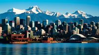
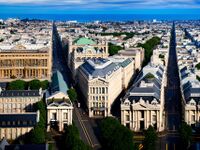
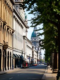
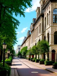
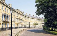
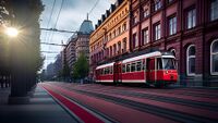
|image_caption = From top to bottom: Gallatin seen from the City Observatory, State Street in Central City, Pinehurst Neighborhood, Conifer Ave in Central City, Gallatin City Hall, Bernard Square, National Museum of Art, Fenburg Park Neighborhood, Cava 3 Tram traveling down a street in the Central City | |image_caption = From top to bottom: Gallatin New City CBD, Gallatin seen from the City Observatory, State Street in Central City, Pinehurst Neighborhood, Conifer Ave in Central City, Gallatin City Hall, Bernard Square, National Museum of Art, Fenburg Park Neighborhood, Cava 3 Tram traveling down a street in the Central City | ||
|image_flag = | |image_flag = | ||
|flag_alt = | |flag_alt = | ||
| Line 104: | Line 105: | ||
|area_blank2_title = | |area_blank2_title = | ||
<!-- square miles --> | <!-- square miles --> | ||
|area_total_sq_mi = | |area_total_sq_mi = 150 | ||
|area_land_sq_mi = | |area_land_sq_mi = 130 | ||
|area_water_sq_mi = | |area_water_sq_mi = 20 | ||
|area_urban_sq_mi = 1, | |area_urban_sq_mi = 1,982 | ||
|area_rural_sq_mi = | |area_rural_sq_mi = | ||
|area_metro_sq_mi = | |area_metro_sq_mi = 6,500 | ||
|area_blank1_sq_mi = | |area_blank1_sq_mi = | ||
|area_blank2_sq_mi = | |area_blank2_sq_mi = | ||
| Line 128: | Line 129: | ||
|population_footnotes = | |population_footnotes = | ||
|population_as_of = 2023 | |population_as_of = 2023 | ||
|population_total = | |population_total = 1,280,000 | ||
|population_density_sq_mi = | |population_density_sq_mi = 9,846 | ||
|population_urban = 3, | |population_urban = 3,937,000 | ||
|population_metro = | |population_metro = 4,145,000 | ||
|population_note = | |population_note = | ||
|population_demonym = | |population_demonym = Gallatiner | ||
|timezone1 = | |timezone1 = | ||
|utc_offset1 = | |utc_offset1 = | ||
| Line 147: | Line 148: | ||
|footnotes = | |footnotes = | ||
}} | }} | ||
'''Gallatin''' is the capital city and largest city of the Republic of [[New Gough Island]]. It is the largest city and the anchor of the Greater Gallatin | '''Gallatin''' is the capital city and largest city of the Republic of [[New Gough Island]]. It is the largest city and the anchor of the Greater Gallatin Area which includes the Gallatin City Region, and the Parasides Island Region. The city has a population of 1,280,000 people as of the 2023 estimate. The city is the most densely populated city in the country. Located in the northern area of the country which houses 85% of the national population in 10% of the land area. The Greater Gallatin area has a population of 4,145,000 with 3,937,000 people living in the urban area. | ||
The city was founded in 1718 but not proclaimed capital of the country until 1870. The city is well known for its historic architecture and art scene. Gallatin and | The city was founded in 1718 but not proclaimed capital of the country until 1870. The city is divided into the island or the old city and the new city or the mainland. The Gallatin Annexation Act of 1930 expanded the city to the size it is today. The city is well known for its historic architecture and art scene. Gallatin Island (old city) and Parasides Island (the new city) as a whole is connected to the mainland (Gough Island) by the 1 mile-long road and rail President Frank Berman Memorial Bridge. The city has a robust transit system connecting itself to the suburbs by commuter rail. Bus and street trams are the main features of the transit system. With a subway system under construction to improve transit in the city. The city has a network of freeways outside of the city limits. | ||
The city attracts the largest amount tourists to the country, with many arriving in the city to travel to the nature and rugged outdoors oriented vast South Area. On average, 8-10 million tourists visit the city each year. For this reason, the city is called the Gateway to New Gough Island. Tourist attractions include: the several historic parks in the city, the National Museum of Art, Bernard Square, City Observatory, national monuments, and much more. | The city attracts the largest amount tourists to the country, with many arriving in the city to travel to the nature and rugged outdoors oriented vast South Area. On average, 8-10 million tourists visit the city each year. For this reason, the city is called the Gateway to New Gough Island. Tourist attractions include: the several historic parks in the city, the National Museum of Art, Bernard Square, City Observatory, national monuments, and much more. | ||
| Line 286: | Line 287: | ||
==Transportation== | ==Transportation== | ||
The Greater Gallatin Transit Authority or GGTA is the provider of public transportation in the Greater Gallatin area. The GGTA covers the city tram network of Gallatin, buses, buses rapid transit, taxis, para transit, and commuter rail. The Tram network has | The Greater Gallatin Transit Authority or GGTA is the provider of public transportation in the Greater Gallatin area. The GGTA covers the city tram network of Gallatin, buses, buses rapid transit, taxis, para transit, and commuter rail. The Tram network has 35 lines city wide. The trams are the vintage Cava 2 (1949-1961) and Cava 3 (1962-1989) which has been kept up over the years. There are 50 city bus lines and 5 bus rapid transit lines. There are 80 bus lines serving the Greater Gallatin area. There are 20,000 taxis severing the Greater Gallatin area. There are 7 commuter rail lines serving the suburbs. As of 2009, the GGTA has been constructing the Gallatin Subway which will be completed in 2024. The subway will have 3 lines, the red, blue, and green lines will make travel easier throughout the city. | ||
The Greater Gallatin area is also served by 8 motorways. With The Perimeter Motorway as a ring road traveling just outside city limits. There are no motorways in the city limits of Gallatin. Gallatin is connected to the rest of the county by the President Frank Berman Memorial Bridge which carries The Gallatin- Greycott Motorway as well as train service across the Queens Strait. Train service is frequent having the Gallatin Union Station as the only place in the city for train service. Gallatin Union Station will be the hub for the subway. | The Greater Gallatin area is also served by 8 motorways. With The Perimeter Motorway as a ring road traveling just outside city limits. There are no motorways in the city limits of Gallatin. Gallatin is connected to the rest of the county by the President Frank Berman Memorial Bridge which carries The Gallatin- Greycott Motorway as well as train service across the Queens Strait. Train service is frequent having the Gallatin Union Station as the only place in the city for train service. Gallatin Union Station will be the hub for the subway. | ||
| Line 293: | Line 294: | ||
===City Streets=== | ===City Streets=== | ||
Gallatin city streets are largely in | Gallatin city streets are largely in 2 planned grid systems from the 1718 and 1930, both have been modified multiple times afterwards. The old city has a network of grand avenues which are usually tree lined and are 4 lanes wide, two lanes in each direction. The new city has a network of streets ranging from 2 lanes to 6 lanes wide. The speed limit for the grand avenues which are main thoroughfares for traffic are 30 mph. One-way streets are also common in the city. Many streets have been redesigned for the inclusion of cycling lanes and traffic calming. There are no motorways in the city limits as the result of the Motorway Exclusion Act of 1950 which prohibited the construction of motorways in the city of Gallatin on the basis of cutting off historic neighborhoods and increasing traffic. It is estimated that 75% of city residents do not commute by a personal vehicle. As of 2023, 60% of residents take public transportation. While 10% walk to commute and 5% bike to work. | ||
There are residential streets which are usually narrow and one-way have a speed limit of 15-20 mph. Many streets are paved with brick or cobblestone and slow careful driving is expected. Residential streets have space for street parking for residents. There are strict school and hospital slow zones which limit speed limits to 15 mph. These zones are on 24/7 regardless if the school is in session or not. Drivers will receive a ACU 150 fine and will be expected to pay within a reasonable amount of time. | There are residential streets which are usually narrow and one-way have a speed limit of 15-20 mph. Many streets are paved with brick or cobblestone and slow careful driving is expected. Residential streets have space for street parking for residents. There are strict school and hospital slow zones which limit speed limits to 15 mph. These zones are on 24/7 regardless if the school is in session or not. Drivers will receive a ACU 150 fine and will be expected to pay within a reasonable amount of time. | ||
===Motorways=== | ===Motorways=== | ||
There are 12 motorways in the Greater Gallatin | There are 12 motorways in the Greater Gallatin Area. These include The Perimeter Motorway which circles the city which is known as the UH-3, the Gallatin-Greycott Motorway which is SH-1, The Eastwood Motorway which is UH-8, The Airport Motorway which is UH-5, The Oakridge Motorway which is SH-10, The Outer Ring Motorway which is UH-4 and SH-2, The Parasides Island Motorway which is SH-16, The Greenwood Motorway which is UH 14, The Hartfield Motorway which is UH 114, The Mountain to Sea Motorway which is SH 20, The Harbor Motorway which is UH 214 and The Cloverfield Motorway which is UH-20. Urban Highway or UH is a motorway within a urban or metro area. While State Highway or SH are national routes that be motorways or rural 2 lane roads. The primary routes are the 18 mile The Perimeter Motorway which carries traffic around the city limits and has exits for city streets. The Perimeter Motorway has the second highest traffic volume in the country with 130,000 vehicles per day traveling with 3 lanes in each direction as it was the first motorway build in the country opened in 1953. The most important motorway is the Gallatin- Greycott Motorway which is one of the three links from Parasides Island to Gough Island (the mainland), the 6 lane (3 lanes in each direction) President Frank Berman Memorial Bridge is a suspension bridge which crosses the mile wide Queens Strait located 30 miles west of the city center carries 100,000 vehicles per day and also has a railway on the lower deck. The Gallatin- Greycott Motorway carries nearly 150,000 vehicles in places closer to the end of the motorway at an interchange with the Perimeter Motorway. | ||
The third busiest motorway is The Eastwood Motorway as it is 28 miles long which mainly serves the eastern suburbs which carries 90,000 vehicles per day. This motorway is tied with The Outer Ring Motorway which is 80 miles long and is 6-8 lanes wide and serves as the bypass for traffic. The Outer Ring Motorway has interchanges with The Gallatin- Greycott Motorway, The Parasides Island Motorway, The Oakridge Motorway, and The Eastwood Motorway. It also serves as the beginning/end of The Airport Motorway which is only 4 miles long and is the shortest motorway in the area. Motorway speed limits range from 40 mph on The Perimeter Motorway to 60 mph on The Outer Ring Motorway. Most motorways have speeds of 50 or 55 mph. | The third busiest motorway is The Eastwood Motorway as it is 28 miles long which mainly serves the eastern suburbs which carries 90,000 vehicles per day. This motorway is tied with The Outer Ring Motorway which is 80 miles long and is 6-8 lanes wide and serves as the bypass for traffic. The Outer Ring Motorway has interchanges with The Gallatin- Greycott Motorway, The Parasides Island Motorway, The Oakridge Motorway, and The Eastwood Motorway. It also serves as the beginning/end of The Airport Motorway which is only 4 miles long and is the shortest motorway in the area. Motorway speed limits range from 40 mph on The Perimeter Motorway to 60 mph on The Outer Ring Motorway. Most motorways have speeds of 50 or 55 mph. | ||
There are 3 Parkways within city limits. The Waterfront Parkway is a two lane divided highway stretching along the waterfront with views of Gallatin Island (the old city). The City Connector Parkway connects the old city and new city via the President Frank Berman Memorial Bridge and is the shortest of the parkways at 2 miles. And The Eastside Parkway travels along the east side of the new city. Speed limits of the parkways are 35 mph. There are no large trucks allowed on the parkways. The parkways are electronically tolled for ACU 4 per one way trip. | |||
[[File:President Frank Berman Memorial Bridge.jpg|thumb|right|The President Frank Berman Memorial Bridge connects Gallatin | [[File:President Frank Berman Memorial Bridge.jpg|thumb|right|The President Frank Berman Memorial Bridge connects Gallatin Island (the old city) to Parasides Island (the new city). The bridge carries 50,000 vehicles per day]] | ||
===Street Trams=== | ===Street Trams=== | ||
The street tram system dates back to the 1860's as horse drawn carriages. The street tram network became electrified in 1898 and rapidly expanded during the early 1900's. At its peak it had 70 lines in the city and the inner suburbs. The increase of car ownership and suburban growth caused ridership to decline in the late 1940's and 1950's. In the 1960's the city introduced bus routes and it replaced half of the tram system by 1968. The tram system was revitalized and expanded the track milage to better serve the population that wasn't able to access the buses. There are 108 miles of track across the city as of 2023. The tram system has 35 routes and is integrated with the rest of the public transportation system. The cost of the tram is ACU 1.25 per one way. At night there are only 5-night lines that run every hour only really serving the city center and government center. Trams run every 5 to 10 minutes at rush hour and 15 to 20 minutes at off peak hours. There are on average up to 250,000 people using the trams per day. | The street tram system dates back to the 1860's as horse drawn carriages. The street tram network became electrified in 1898 and rapidly expanded during the early 1900's. At its peak it had 70 lines in the city and the inner suburbs. The increase of car ownership and suburban growth caused ridership to decline in the late 1940's and 1950's. In the 1960's the city introduced bus routes and it replaced half of the tram system by 1968. The tram system was revitalized and expanded the track milage to better serve the old city population that wasn't able to access the buses. There are 108 miles of track across the city as of 2023. The tram system has 35 routes and is integrated with the rest of the public transportation system. The cost of the tram is ACU 1.25 per one way. At night there are only 5-night lines that run every hour only really serving the city center and government center. Trams run every 5 to 10 minutes at rush hour and 15 to 20 minutes at off peak hours. There are on average up to 250,000 people using the trams per day. | ||
[[File:Tram in Gallatin.jpg|thumb|right|A Cava 2 Tram traveling down a City Center Street]] | [[File:Tram in Gallatin.jpg|thumb|right|A Cava 2 Tram traveling down a City Center Street]] | ||
===Buses and Bus Rapid Transit=== | ===Buses and Bus Rapid Transit=== | ||
Buses were introduced in 1963 and rapidly expanded during the late 1960's and 1970's. The city has | Buses were introduced in 1963 and rapidly expanded during the late 1960's and 1970's. The city has 50 bus lines. They serve the streets in the new city. They run throughout the city and cost ACU 1 within city limits one way. There are 5 Bus Rapid Transit lines which are as frequent as every 5 minutes during the rush hour and 10 minutes on off peak hours. BRT uses bus lanes and bus traffic signals to help keep the system efficient. The regular bus service is as frequent as every 15 minutes at rush hour and 30 minutes at off peak hours. There are 75 buses lines to and from the suburbs and routes within suburbs. Greycott has 50 bus lines serving the city. The suburb to city buses run every 30 minutes during rush hour to every hour during off peak hours. The suburb to suburb or within suburb bus routes are less frequent and range from every 20 to 40 minutes at peak rush hour to every hour during off peak hours. There are 5 night lines for buses only serving the city's main thoroughfares. There are 8 city to suburb night bus lines. All night lines run every hour. Night lines are available 12 am to 5 am. There is one Gallatin- Greycott bus line that runs 24/7 that runs every 30 minutes during the day and every 1 hour at night. There are 300,000 commuters that use the bus on average every day. | ||
===Commuter Rail and connection to the National Rail Network=== | ===Commuter Rail and connection to the National Rail Network=== | ||
Commuter rail lines were started in the 1960's. There are 8 lines connecting the city to the inner and outer suburbs. During peak hours they run every 30 minutes and every hour at off peak hours | Commuter rail lines were started in the 1960's. There are 8 lines connecting the city to the inner and outer suburbs. During peak hours they run every 30 minutes and every hour at off peak hours. The commuter rail runs from 5 am to 10 pm every day. And cost can vary, as it cost ACU 10 during the weekdays one way, to ACU 5 every weekend per one way. There are up to 250,000 commuters that use it every day on average. The city has daily train service to the rest of the country provided by the National Rail Service Authority out of Gallatin Union Station. The rail line between Gallatin and Greycott is the busiest rail line in the system. | ||
===Cycling and Walkability=== | ===Cycling and Walkability=== | ||
| Line 325: | Line 328: | ||
==City Neighborhoods== | ==City Neighborhoods== | ||
There are | There are 39 city neighborhoods | ||
Old City Neighborhoods | |||
• City Center | • City Center | ||
| Line 366: | Line 370: | ||
• Kingston | • Kingston | ||
New City Neighborhoods | |||
• New City Central Business District | |||
• The Arts District | |||
• The Gayborhood | |||
• The Port | |||
• Waterfront Park | |||
• East Fox Point | |||
• West Fox Point | |||
• Southbridge | |||
• Hartridge | |||
• New Oakridge | |||
• Westerlin | |||
• Zaledo | |||
• Haymarket | |||
• Eastside | |||
• Perimeter Heights | |||
• Garden Estates | |||
• Flatiron | |||
• Edward Town | |||
• Princeton | |||
==Education== | ==Education== | ||
Revision as of 02:52, 11 April 2024
Gallatin | |
|---|---|
Capital City and Region | |
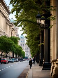
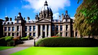
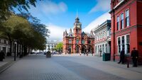
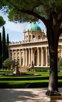
From top to bottom: Gallatin New City CBD, Gallatin seen from the City Observatory, State Street in Central City, Pinehurst Neighborhood, Conifer Ave in Central City, Gallatin City Hall, Bernard Square, National Museum of Art, Fenburg Park Neighborhood, Cava 3 Tram traveling down a street in the Central City | |
| Country | New Gough Island |
| Region | Gallatin |
| Government | |
| • Executive Mayor | James Parker |
| Area | |
| • Capital City and Region | 150 sq mi (400 km2) |
| • Land | 130 sq mi (300 km2) |
| • Water | 20 sq mi (50 km2) |
| • Urban | 1,982 sq mi (5,130 km2) |
| • Metro | 6,500 sq mi (17,000 km2) |
| Population (2023) | |
| • Capital City and Region | 1,280,000 |
| • Density | 9,846/sq mi (3,802/km2) |
| • Urban | 3,937,000 |
| • Metro | 4,145,000 |
| Demonym | Gallatiner |
Gallatin is the capital city and largest city of the Republic of New Gough Island. It is the largest city and the anchor of the Greater Gallatin Area which includes the Gallatin City Region, and the Parasides Island Region. The city has a population of 1,280,000 people as of the 2023 estimate. The city is the most densely populated city in the country. Located in the northern area of the country which houses 85% of the national population in 10% of the land area. The Greater Gallatin area has a population of 4,145,000 with 3,937,000 people living in the urban area.
The city was founded in 1718 but not proclaimed capital of the country until 1870. The city is divided into the island or the old city and the new city or the mainland. The Gallatin Annexation Act of 1930 expanded the city to the size it is today. The city is well known for its historic architecture and art scene. Gallatin Island (old city) and Parasides Island (the new city) as a whole is connected to the mainland (Gough Island) by the 1 mile-long road and rail President Frank Berman Memorial Bridge. The city has a robust transit system connecting itself to the suburbs by commuter rail. Bus and street trams are the main features of the transit system. With a subway system under construction to improve transit in the city. The city has a network of freeways outside of the city limits.
The city attracts the largest amount tourists to the country, with many arriving in the city to travel to the nature and rugged outdoors oriented vast South Area. On average, 8-10 million tourists visit the city each year. For this reason, the city is called the Gateway to New Gough Island. Tourist attractions include: the several historic parks in the city, the National Museum of Art, Bernard Square, City Observatory, national monuments, and much more.
History
Geography
Climate
The climate of Gallatin is Subpolar Oceanic. With cool to mild summers and wet cold and sometimes snowy winters. The city is one of the wettest places in the country with the North West Rainforest being wetter. The city is in the path of a lot of low pressure systems. During the winter snow is common with most snow days bringing 1-2 in (2.5-5 cm) per snow day. Heavy snow storms and blizzards happen at least once a year. However, both heavy rainfall and snow events are becoming more common.
| Climate data for City Observatory, Gallatin, New Gough Island, 1991–2020 normals, extremes 1900–present | |||||||||||||
|---|---|---|---|---|---|---|---|---|---|---|---|---|---|
| Month | Jan | Feb | Mar | Apr | May | Jun | Jul | Aug | Sep | Oct | Nov | Dec | Year |
| Record high °F (°C) | 80 (27) |
79 (26) |
77 (25) |
72 (22) |
64 (18) |
59 (15) |
54 (12) |
52 (11) |
58 (14) |
63 (17) |
68 (20) |
73 (23) |
80 (27) |
| Average high °F (°C) | 63 (17) |
61 (16) |
55 (13) |
47 (8) |
44 (7) |
42 (6) |
41 (5) |
41 (5) |
43 (6) |
48 (9) |
54 (12) |
58 (14) |
50 (10) |
| Average low °F (°C) | 50 (10) |
46 (8) |
42 (6) |
36 (2) |
32 (0) |
27 (−3) |
24 (−4) |
25 (−4) |
28 (−2) |
34 (1) |
41 (5) |
45 (7) |
36 (2) |
| Record low °F (°C) | 36 (2) |
32 (0) |
22 (−6) |
10 (−12) |
1 (−17) |
−9 (−23) |
−14 (−26) |
−3 (−19) |
4 (−16) |
12 (−11) |
24 (−4) |
31 (−1) |
−14 (−26) |
| Average precipitation inches (mm) | 3.71 (94) |
4.01 (102) |
4.28 (109) |
4.89 (124) |
5.14 (131) |
5.56 (141) |
6.23 (158) |
6.28 (160) |
5.53 (140) |
4.83 (123) |
4.38 (111) |
4.12 (105) |
58.96 (1,498) |
| Average snowfall inches (cm) | 0 (0) |
0 (0) |
0 (0) |
1 (2.5) |
4 (10) |
9 (23) |
12 (30) |
10 (25) |
10 (25) |
9 (23) |
4 (10) |
1 (2.5) |
60 (151) |
| Average precipitation days (≥ 0.01 in) | 9 | 10 | 12 | 12 | 13 | 14 | 15 | 16 | 15 | 14 | 12 | 10 | 152 |
| Average snowy days (≥ 0.1 in) | 0 | 0 | 0 | 1 | 4 | 7 | 10 | 9 | 8 | 7 | 3 | 1 | 50 |
| Source: New Gough Island Weather Service | |||||||||||||
Transportation
The Greater Gallatin Transit Authority or GGTA is the provider of public transportation in the Greater Gallatin area. The GGTA covers the city tram network of Gallatin, buses, buses rapid transit, taxis, para transit, and commuter rail. The Tram network has 35 lines city wide. The trams are the vintage Cava 2 (1949-1961) and Cava 3 (1962-1989) which has been kept up over the years. There are 50 city bus lines and 5 bus rapid transit lines. There are 80 bus lines serving the Greater Gallatin area. There are 20,000 taxis severing the Greater Gallatin area. There are 7 commuter rail lines serving the suburbs. As of 2009, the GGTA has been constructing the Gallatin Subway which will be completed in 2024. The subway will have 3 lines, the red, blue, and green lines will make travel easier throughout the city.
The Greater Gallatin area is also served by 8 motorways. With The Perimeter Motorway as a ring road traveling just outside city limits. There are no motorways in the city limits of Gallatin. Gallatin is connected to the rest of the county by the President Frank Berman Memorial Bridge which carries The Gallatin- Greycott Motorway as well as train service across the Queens Strait. Train service is frequent having the Gallatin Union Station as the only place in the city for train service. Gallatin Union Station will be the hub for the subway.
It is estimated that 60% of city residents use public transportation regularly with 30% of commuters from the Greater Gallatin area using public transportation to go in and out of the city.
City Streets
Gallatin city streets are largely in 2 planned grid systems from the 1718 and 1930, both have been modified multiple times afterwards. The old city has a network of grand avenues which are usually tree lined and are 4 lanes wide, two lanes in each direction. The new city has a network of streets ranging from 2 lanes to 6 lanes wide. The speed limit for the grand avenues which are main thoroughfares for traffic are 30 mph. One-way streets are also common in the city. Many streets have been redesigned for the inclusion of cycling lanes and traffic calming. There are no motorways in the city limits as the result of the Motorway Exclusion Act of 1950 which prohibited the construction of motorways in the city of Gallatin on the basis of cutting off historic neighborhoods and increasing traffic. It is estimated that 75% of city residents do not commute by a personal vehicle. As of 2023, 60% of residents take public transportation. While 10% walk to commute and 5% bike to work.
There are residential streets which are usually narrow and one-way have a speed limit of 15-20 mph. Many streets are paved with brick or cobblestone and slow careful driving is expected. Residential streets have space for street parking for residents. There are strict school and hospital slow zones which limit speed limits to 15 mph. These zones are on 24/7 regardless if the school is in session or not. Drivers will receive a ACU 150 fine and will be expected to pay within a reasonable amount of time.
Motorways
There are 12 motorways in the Greater Gallatin Area. These include The Perimeter Motorway which circles the city which is known as the UH-3, the Gallatin-Greycott Motorway which is SH-1, The Eastwood Motorway which is UH-8, The Airport Motorway which is UH-5, The Oakridge Motorway which is SH-10, The Outer Ring Motorway which is UH-4 and SH-2, The Parasides Island Motorway which is SH-16, The Greenwood Motorway which is UH 14, The Hartfield Motorway which is UH 114, The Mountain to Sea Motorway which is SH 20, The Harbor Motorway which is UH 214 and The Cloverfield Motorway which is UH-20. Urban Highway or UH is a motorway within a urban or metro area. While State Highway or SH are national routes that be motorways or rural 2 lane roads. The primary routes are the 18 mile The Perimeter Motorway which carries traffic around the city limits and has exits for city streets. The Perimeter Motorway has the second highest traffic volume in the country with 130,000 vehicles per day traveling with 3 lanes in each direction as it was the first motorway build in the country opened in 1953. The most important motorway is the Gallatin- Greycott Motorway which is one of the three links from Parasides Island to Gough Island (the mainland), the 6 lane (3 lanes in each direction) President Frank Berman Memorial Bridge is a suspension bridge which crosses the mile wide Queens Strait located 30 miles west of the city center carries 100,000 vehicles per day and also has a railway on the lower deck. The Gallatin- Greycott Motorway carries nearly 150,000 vehicles in places closer to the end of the motorway at an interchange with the Perimeter Motorway.
The third busiest motorway is The Eastwood Motorway as it is 28 miles long which mainly serves the eastern suburbs which carries 90,000 vehicles per day. This motorway is tied with The Outer Ring Motorway which is 80 miles long and is 6-8 lanes wide and serves as the bypass for traffic. The Outer Ring Motorway has interchanges with The Gallatin- Greycott Motorway, The Parasides Island Motorway, The Oakridge Motorway, and The Eastwood Motorway. It also serves as the beginning/end of The Airport Motorway which is only 4 miles long and is the shortest motorway in the area. Motorway speed limits range from 40 mph on The Perimeter Motorway to 60 mph on The Outer Ring Motorway. Most motorways have speeds of 50 or 55 mph.
There are 3 Parkways within city limits. The Waterfront Parkway is a two lane divided highway stretching along the waterfront with views of Gallatin Island (the old city). The City Connector Parkway connects the old city and new city via the President Frank Berman Memorial Bridge and is the shortest of the parkways at 2 miles. And The Eastside Parkway travels along the east side of the new city. Speed limits of the parkways are 35 mph. There are no large trucks allowed on the parkways. The parkways are electronically tolled for ACU 4 per one way trip.
Street Trams
The street tram system dates back to the 1860's as horse drawn carriages. The street tram network became electrified in 1898 and rapidly expanded during the early 1900's. At its peak it had 70 lines in the city and the inner suburbs. The increase of car ownership and suburban growth caused ridership to decline in the late 1940's and 1950's. In the 1960's the city introduced bus routes and it replaced half of the tram system by 1968. The tram system was revitalized and expanded the track milage to better serve the old city population that wasn't able to access the buses. There are 108 miles of track across the city as of 2023. The tram system has 35 routes and is integrated with the rest of the public transportation system. The cost of the tram is ACU 1.25 per one way. At night there are only 5-night lines that run every hour only really serving the city center and government center. Trams run every 5 to 10 minutes at rush hour and 15 to 20 minutes at off peak hours. There are on average up to 250,000 people using the trams per day.
Buses and Bus Rapid Transit
Buses were introduced in 1963 and rapidly expanded during the late 1960's and 1970's. The city has 50 bus lines. They serve the streets in the new city. They run throughout the city and cost ACU 1 within city limits one way. There are 5 Bus Rapid Transit lines which are as frequent as every 5 minutes during the rush hour and 10 minutes on off peak hours. BRT uses bus lanes and bus traffic signals to help keep the system efficient. The regular bus service is as frequent as every 15 minutes at rush hour and 30 minutes at off peak hours. There are 75 buses lines to and from the suburbs and routes within suburbs. Greycott has 50 bus lines serving the city. The suburb to city buses run every 30 minutes during rush hour to every hour during off peak hours. The suburb to suburb or within suburb bus routes are less frequent and range from every 20 to 40 minutes at peak rush hour to every hour during off peak hours. There are 5 night lines for buses only serving the city's main thoroughfares. There are 8 city to suburb night bus lines. All night lines run every hour. Night lines are available 12 am to 5 am. There is one Gallatin- Greycott bus line that runs 24/7 that runs every 30 minutes during the day and every 1 hour at night. There are 300,000 commuters that use the bus on average every day.
Commuter Rail and connection to the National Rail Network
Commuter rail lines were started in the 1960's. There are 8 lines connecting the city to the inner and outer suburbs. During peak hours they run every 30 minutes and every hour at off peak hours. The commuter rail runs from 5 am to 10 pm every day. And cost can vary, as it cost ACU 10 during the weekdays one way, to ACU 5 every weekend per one way. There are up to 250,000 commuters that use it every day on average. The city has daily train service to the rest of the country provided by the National Rail Service Authority out of Gallatin Union Station. The rail line between Gallatin and Greycott is the busiest rail line in the system.
Cycling and Walkability
The city has the highest walkability score in the country. The city has invested into the bike lanes and pathways in recent years. There are 100 miles of bike lanes and pathways across the city.
Gallatin Subway
The Gallatin Subway has been under construction since 2009. Phase 1 is set to compete in 2024 and open soon after. There are 3 lines with phase one, the red line which will serve the city center and government center, the green line which will serve the eastern part of the city and the blue line which will serve the west part of the city. Phase 2 will begin in 2024 and will be completed in 2029 which will be the orange line which will connect all lines in a semi-circle, and the purple line which will cover the south and north of the city. It is hoped that up to 100,0000 to 200,000 people or more will use the subway once it is competed in 2029.
Culture
City Government
City Neighborhoods
There are 39 city neighborhoods
Old City Neighborhoods • City Center
• Fenburg Park
• Pinehurst
• Bernard Square
• Stratford
• Berlint
• Mangata
• Hanover Park
• Raynham
• Betty's Corner
• Confier Forrest
• Evergreen Terrace
• Berman
• Crossway
• Newport Park
• Harrison Heights
• Westminster
• Government Center
• Marble Field
• Kingston
New City Neighborhoods • New City Central Business District
• The Arts District
• The Gayborhood
• The Port
• Waterfront Park
• East Fox Point
• West Fox Point
• Southbridge
• Hartridge
• New Oakridge
• Westerlin
• Zaledo
• Haymarket
• Eastside
• Perimeter Heights
• Garden Estates
• Flatiron
• Edward Town
• Princeton
Education
Economy
Sister Cities
Králowec, F.D., Morrawia (2000)
