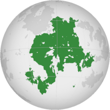
Olivacia
This article is incomplete because it is pending further input from participants, or it is a work-in-progress by one author. Please comment on this article's talk page to share your input, comments and questions. Note: To contribute to this article, you may need to seek help from the author(s) of this page. |
 | |
| Area | 100 km2 (39 sq mi) (6th) |
|---|---|
| Population | TBD |
| Population density | TBD |
| GDP (nominal) | TBD |
| GDP (PPP) | TBD |
| GDP per capita | TBD |
| HDI | TBD |
| Ethnic groups |
|
| Religions |
|
| Demonym | Olivacian |
| Countries | TBD |
| Dependencies | 2 |
| Languages |
|
| Time zones | UTC +3 to +9 |
| Largest cities | Largest urban areas:
|
Olivacia is a landmass comprising the totality of Northeastern and South Olivacia. Olivacia make up a third of the land in Anteria's Eastern Hemisphere and comprise the New World alongside Astariax, Meredonne and Caliandia. Unlike its New Worlder neighbors, Olivacia was perhaps the least colonized continent of Anteria, despite its discovery discovery to the Western world in 1489 still relevant to history.
Etymology
History
Geography
Countries and territories
Countries
As of 2021, there are 25 recognized nations in Olivacia, which are listed here:
| Flag | Arms | Name | Official language | Area (km2) |
Population | Population density (per km2) |
Capital |
|---|---|---|---|---|---|---|---|
| Gran Rugido
(Spanish: República Federal de Gran Rugido) |
Spanish and 48 indigenous languages | 1,230,307 | 52,165,016 | 42.4 km2 | San Jorge Xayacatlán | ||
| Hoterallia (Hoterallian: ほてらじあの第二帝国) |
Hoterallian Central Hoterallian (Recognised regional language) |
788,103 | 76,504,980 | 97.07 km2 | Orajioe | ||

|
Nunoguay
(Spanish: República de Nunoguay) |
Spanish and Duarani | TBA | 6,355,407 | El Farenzia |
Territories
A number of dependencies, enjoying varying degrees of autonomy, are found within Olivacia or nearby. These dependencies are not sovereign entities in their own rights, but rather constitute the sovereign territory of a larger state. However, they are not integral political units, regarded as separate from the main territory of their parent state.
| Flag | Arms | Name | Sovereign state |
Name in official language |
Area (km2) |
Population | Population density (per km2) |
Capital |
|---|---|---|---|---|---|---|---|---|
| Country of Freice | Riamo | Pưƞqyǡ 'gi frɨs | 121.3 km2 | 14,158 | 117 | Frɨs ưɟte̩qąl | ||
| Template:Country data Layfet | TBA | Layfet | Vultesia | None | 324 km2 | 8,431,700 | 26,023 | Layfet |
| TBA | The Prefectural Kingdom of Sagolsh | Hoterallia | 象国都道王国 | 113 km2 | 29,752 | 261 | Shinminato (新港) |
Demography
Terminology
Economy