Tsinkin: Difference between revisions
Jump to navigation
Jump to search
(Blanked the page) Tag: Blanking |
(Undo revision 215729 by PaperMoonKing (talk)) Tag: Undo |
||
| Line 1: | Line 1: | ||
{{Infobox country | |||
|native_name = <!--e.g. France--> Mokingpudöva | |||
|conventional_long_name = <!--Conventional English long-form--> The Democratic States Of Mokingpudöva | |||
|common_name = <!--Common English name--> Mokingpudova | |||
|image_flag = <!--* e.g. Flag of country.svg--> [[File:Mokingpudovajpg.jpeg|200px|thumb|center]] | |||
|alt_flag = <!--Alt text--> Flag of Mokingpudova | |||
|image_coat = <!--* e.g. Coat of arms of country.svg--> | |||
|alt_coat = <!--alt text for coat of arms--> | |||
|symbol_type = <!--emblem/seal/... based on image_coat--> | |||
|national_motto = <!--"[[motto]]"--> "[[Kuuyi, maqas, qatsi]]" | |||
|national_anthem = <!--''[[name of/link to anthem]]''--> | |||
|royal_anthem = <!--''[[name of/link to anthem]]''--> | |||
|other_symbol_type = <!--Another symbol, e.g. Hymn--> | |||
|other_symbol = <!--another symbol text--> | |||
|image_map = <!--e.g. LocationCountry.svg--> [[File:MokingpudovaMap.jpeg|200px|thumb|center]] | |||
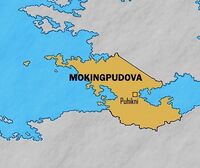
|alt_map = <!--alt text for map--> Mokingpudova with Puhikni | |||
|map_caption = <!--Caption to place below map--> Mokingpudova with Puhikni | |||
|image_map2 = <!--Another map, if required--> | |||
|alt_map2 = <!--alt text for second map--> | |||
|map_caption2 = <!--Caption to place below second map--> | |||
|capital = <!--e.g. Paris--> Puhikni | |||
|latd= | latm= | latNS = <!--capital's latitude degree/min/dir--> | |||
|longd= |longm= |longEW = <!--capital's longitude deg/min/dir--> | |||
|largest_city = <!--Largest city or settlement: --> Puhikni | |||
|largest_settlement = <!--(if not a city)--> | |||
|largest_settlement_type = <!--Type of settlement if largest settlement not a city--> | |||
|official_languages = <!--e.g. English, French--> None | |||
|national_languages = <!--Officially recognized national languages--> Hopi, English | |||
|regional_languages = <!--Officially recognized regional languages--> N/A | |||
|languages_type = <!--Other type of languages --> | |||
|languages = <!--Other languages list--> | |||
|ethnic_groups = <!--List/breakdown of ethnic groups--> | |||
|ethnic_groups_year = <!--Year of ethnic data (if provided)--> | |||
|demonym = <!--e.g. American--> Mokingpudovan | |||
|government_type = Constitutional Democracy | |||
|leader_title1 = <!-- e.g. President--> President | |||
|leader_name1 = <!-- e.g. Barack Obama--> Nàapina Naa'öna | |||
|leader_title2 = Founder | |||
|leader_name2 = Hotsko Wuwan'aya | |||
|leader_title6 = | |||
|leader_name6 = | |||
|sovereignty_type = | |||
|sovereignty_note = | |||
|established_event1 = | |||
|established_date1 = | |||
|established_event2 = | |||
|established_date2 = | |||
|established_event9 = | |||
|established_date9 = | |||
|area_rank = | |||
|area_magnitude = | |||
|area = <!-- major area size (in [[Template:convert]] either km2 or sqmi first) --> | |||
|area_km2 = <!-- major area size (in square km) --> | |||
|area_sq_mi = <!-- area in square mi (requires area_km2) --> | |||
|area_footnote = <!-- optional footnote for area --> | |||
|percent_water = | |||
|area_label = <!-- label under "Area" (default: Total) --> | |||
|area_label2 = <!-- label below area_label (optional) --> | |||
|area_dabodyalign = <!-- text after area_label2 (optional) --> | |||
|population_estimate = | |||
|population_estimate_rank = | |||
|population_estimate_year = | |||
|population_census = 13,095,000 | |||
|population_census_year = 2018 | |||
|population_density_km2 = | |||
|population_density_sq_mi = | |||
|population_density_rank = | |||
|GDP_PPP = | |||
|GDP_PPP_rank = | |||
|GDP_PPP_year = | |||
|GDP_PPP_per_capita = | |||
|GDP_PPP_per_capita_rank = | |||
|GDP_nominal = | |||
|GDP_nominal_rank = | |||
|GDP_nominal_year = | |||
|GDP_nominal_per_capita = | |||
|GDP_nominal_per_capita_rank = | |||
|Gini = | |||
|Gini_rank = | |||
|Gini_year = | |||
|Gini_change = <!--increase/decrease/stable--> | |||
|Gini_category = | |||
|HDI = | |||
|HDI_rank = | |||
|HDI_year = | |||
|HDI_change = <!--increase/decrease/stable--> | |||
|HDI_category = | |||
|currency = Piviskuyi | |||
|currency_code = MKP | |||
|time_zone = +9 | |||
|utc_offset = <!-- +N, where N is number of hours--> | |||
|time_zone_DST = | |||
|antipodes = <!-- countries or islands antipodal to this one--> | |||
|date_format = <!-- numeric dates (dd-mm-yyyy, yyyy.mm.dd, etc.) plus era (AD, AH, etc.) --> | |||
|DST_note = | |||
|utc_offset_DST = <!-- +N, where N is number of hours--> | |||
|drives_on = <!-- vehicles drive on the left or right of the road --> Right | |||
|cctld = .mok | |||
|iso3166code = MK | |||
|calling_code = +24 | |||
|image_map3 = | |||
|alt_map3 = | |||
|footnotes = <!--for any generic non-numbered footnotes--> | |||
|footnote1 = | |||
|footnote2 = | |||
<!-- ... --> | |||
|footnote7 = | |||
}} | |||
'''Mokingpudöva''', officially the '''Democratic States of Mokingpudöva''', is a constitutional democracy leaded by president Nàapina Naa'öna with Alternative vote elections. Mokingpudöva is located in North East [[Meredonne]], in [[Anteria]], and boasts the primacy of fishing and terrace farming of the world. | |||
==History== | |||
Mokingpudova first existed as 4 separate tribes. The [[Kwasipaatuwaqatsi]], [[Patuphadokwi]], [[Patuphaqlo]], and [[Bunupaatuwaqatsi]]. In 600~800 BC Hotsko Wuwan'aya unified the four tribes under the name Mokingpudova. | |||
==Geography== | |||
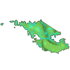
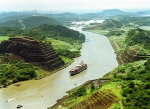
Mokingpudova is full of rivers, mountains, and a desert. | |||
[[File:MokingpudovaTerrain.png|thumb|Darker areas are higher and lighter areas are lower]] | |||
[[File:MokingpudovaRiver.jpg|thumb|Photo of Puhikni River]] | |||
===Climate=== | |||
The climate of Mokingpudova is sub-tropical. | |||
===Environment=== | |||
In the forests of Mokingpudova live many creatures including are national animal the Java Mouse Deer. | |||
==Politics and Government== | |||
===Military=== | |||
===Foreign Relations=== | |||
===Infrastructure=== | |||
==Demographics== | |||
===Education=== | |||
===Religion=== | |||
===Culture=== | |||
====Music and Art==== | |||
====Cuisine==== | |||
====Sports==== | |||
[[Category:Anteria]] | |||
{{Template:Anteria info pages}} | |||
Revision as of 21:45, 4 June 2020
The Democratic States Of Mokingpudöva Mokingpudöva | |
|---|---|
|
Flag | |
| Motto: "Kuuyi, maqas, qatsi" | |
Mokingpudova with Puhikni | |
| Capital and | Puhikni |
| Official languages | None |
| Recognised national languages | Hopi, English |
| Recognised regional languages | N/A |
| Demonym(s) | Mokingpudovan |
| Government | Constitutional Democracy |
• President | Nàapina Naa'öna |
• Founder | Hotsko Wuwan'aya |
| Population | |
• 2018 census | 13,095,000 |
| Currency | Piviskuyi (MKP) |
| Time zone | +9 |
| Driving side | right |
| Calling code | +24 |
| ISO 3166 code | MK |
| Internet TLD | .mok |
Mokingpudöva, officially the Democratic States of Mokingpudöva, is a constitutional democracy leaded by president Nàapina Naa'öna with Alternative vote elections. Mokingpudöva is located in North East Meredonne, in Anteria, and boasts the primacy of fishing and terrace farming of the world.
History
Mokingpudova first existed as 4 separate tribes. The Kwasipaatuwaqatsi, Patuphadokwi, Patuphaqlo, and Bunupaatuwaqatsi. In 600~800 BC Hotsko Wuwan'aya unified the four tribes under the name Mokingpudova.
Geography
Mokingpudova is full of rivers, mountains, and a desert.
Climate
The climate of Mokingpudova is sub-tropical.
Environment
In the forests of Mokingpudova live many creatures including are national animal the Java Mouse Deer.
Politics and Government
Military
Foreign Relations
Infrastructure
Demographics
Education
Religion
Culture
Music and Art
Cuisine
Sports


