New Gough Island
Country of New Gough Island | |
|---|---|
| Anthem: The Great New Gough Island | |
 | |
| Status | Recognised as a country of Riamo with independence in foreign relations de jure; operating as an independent state under Riamese protection de facto (since 1980). |
| Capital | Port Victoria |
| Largest | Hartridge |
| Official languages | Common |
| Recognised regional languages | Gough |
| Ethnic groups (2024) | White (74%) Black (12%) East Asian (8%) Native (4%) Mixed Race (2%) |
| Religion (2024) | Non Religious (47%) Christan (45%) East Asian Religions (5%) Native Gough Religions (2%) Other (1%) |
| Demonym(s) | New Gough Islander |
| Government | Unitary Executive lead Democracy under a federal constitutional monarchy |
• Monarch | Diana II |
• Chief Executive | Helen Zealand |
• Vice Chief Executive | Richard Wright |
| Legislature | National Assembly |
| Country of Riamo | |
• Arrival of the First Colonists | 1609 |
• Self Governed Colony | January 1, 1955 |
• Recognition of independence in foreign relations | July 8, 1980 |
| Area | |
• | 60,528 sq mi (156,770 km2) |
• Water (%) | 0.8 |
| Population | |
• 2024 census | 11,160,000 |
• Density | 184.4/sq mi (71.2/km2) |
| GDP (nominal) | 2024 estimate |
• Total | ACU 223.2 Billion |
• Per capita | ACU 20,000 |
| Gini (2024) | 34.6 medium |
| HDI (2024) | very high |
| Currency | New Gough island Hull (NGIH) |
| Time zone | New Gough Island Time |
| Date format | mm/dd/yyyy |
| Driving side | left |
| Calling code | +53 |
| Internet TLD | .ng |
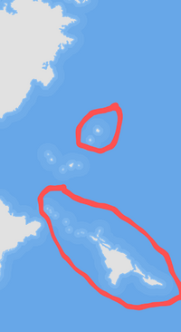
New Gough Island officially the Country of New Gough Island or less commonly known, The State of New Gough Island is a country in the southern hemisphere. The country is made up of a large island and a smaller islands. As of the 2024 census, the nation's population stood at 11.16 million. The country has a land area of 60,528 sq mi. The capital city is Port Victoria. While the largest city is Hartridge. The half of the country's population lives on the highly populated South Península and South East Regions which are home to the largest city and capital city. While the country is highly mountainous along the west and south west coasts and forested with some rolling hills. The climate of the country is temperate, with some spots in humid subtropical and tropical climate zones.
History
Demographics
Largest City Proper in New Gough Island
2024 Census | |||||||||
|---|---|---|---|---|---|---|---|---|---|
| Rank | Region | Pop. | |||||||
 ]] ]][[Hartridge]]  Gough City |
1 | [[Hartridge]] | South Peninsula | 438,000 |  Parsides City  Jarvis Bay | ||||
| 2 | Gough City | South Peninsula | 237,000 | ||||||
| 3 | Parsides City | Parasides Islands | 207,000 | ||||||
| 4 | Jarvis Bay | North Coast | 191,000 | ||||||
| 5 | [[Port Victoria]] | South East Islands | 179,000 | ||||||
| 6 | Gladen | Northern Island Chain | 163,000 | ||||||
| 7 | Golden | Eastern Lands | 148,000 | ||||||
| 8 | Berman | South Peninsula | 136,000 | ||||||
| 9 | Westberg | South East Islands | 120,000 | ||||||
| 10 | New Verdun | West Coast | 108,000 | ||||||
| Historical population | ||
|---|---|---|
| Year | Pop. | ±% |
| 1730 | 10,000 | — |
| 1750 | 50,000 | +400.0% |
| 1800 | 200,000 | +300.0% |
| 1820 | 780,000 | +290.0% |
| 1850 | 968,000 | +24.1% |
| 1870 | 1,380,000 | +42.6% |
| 1880 | 1,900,000 | +37.7% |
| 1890 | 2,250,000 | +18.4% |
| 1900 | 2,700,000 | +20.0% |
| 1910 | 3,180,000 | +17.8% |
| 1920 | 3,808,000 | +19.7% |
| 1930 | 4,290,000 | +12.7% |
| 1940 | 4,800,000 | +11.9% |
| 1950 | 5,090,000 | +6.0% |
| 1960 | 5,775,000 | +13.5% |
| 1970 | 6,587,000 | +14.1% |
| 1980 | 7,420,000 | +12.6% |
| 1990 | 8,020,000 | +8.1% |
| 2000 | 8,850,000 | +10.3% |
| 2010 | 10,080,000 | +13.9% |
| 2020 | 10,989,000 | +9.0% |
| 2024 | 11,160,000 | +1.6% |
Geography
The geography of New Gough Island is quite diverse. The major geographic features are the Western Alps, the Northern Coastal Ranges and the Southern Coastal Ranges. As well as the Eastern plains and the West Coast Rainforest, the New Gough Island forest and the tropical Parasides Islands.
Climate
The climate of New Gough Island is largely temperate. With the northern part of the country being humid subtropical and the northern most Parasides Islands being tropical. The majority of the country is temperate with plentiful precipitation. Mild to warm summers to cool to cold winters are common. Heatwaves and Cold waves are common but aren't intense. Snow and wintery precipitation is common in the mountains and highlands during the cooler parts of the year. Temperatures in the temperate zone range from 63 degrees F (17 degrees C) to 77 degrees F (25 degrees C) during the summer to 41 degrees F (5 degrees C) to 59 degrees F (15 degrees C), precipitation ranges from 40 in (1,016 mm) in the Eastern Plains to 200 in (5,080 mm) at Candace Sound on the West Coast.
The Western Alps, the Northern Coastal Ranges and the Southern Coastal Ranges see snow from as early as late March to as late as early December. Snowfall can be measured in feet in some places. Snow can occur at sea-level usually once a year. The coldest temperature ever recorded was on Mount Reginia at -21 degrees F (-29 degrees C). The Western Alps receive the most snow out of all the mountain ranges.
The Northern most part of the country is humid subtropical, with temperatures ranging from 77 degrees F (25 degrees C) to 84 (29 degrees C) during the summer from 63 degrees F (17 degrees C) to 68 degrees F (20 degrees C) during the winter. Rainfall ranges from 60 in (1,524 mm) to 80 in (2,032 mm). The hottest temperature ever recorded was 104 degrees F (40 degrees C). Heatwaves are common in the area with high humidity.
The Parasides Islands are the only tropical area in the country. Temperatures range from 90 degrees F (32 degrees C) during the summer to 80 degrees F (27 degrees C) during the winter. Rainfall is 70 in (1,778 mm).
Administrative Divisions
Regions
| Name | Population | Land Area | Population Density | Capital | Largest City |
|---|---|---|---|---|---|
| South Peninsula | 3,906,000 | 4,700 sq mi | 831.1 people per sq mi | Gough City | Hartridge |
| West Coast | 770,000 | 9,100 sq mi | 84.6 people per sq mi | New Verdun | New Verdun |
| Parasides Islands | 884,000 | 1,837 sq mi | 481.2 people per sq mi | Parasides City | Parasides City |
| North Coast | 1,680,000 | 10,250 sq mi | 163.9 people per sq mi | Jarvis Bay | Jarvis Bay |
| South East Islands | 2,800,000 | 8,834 sq mi | 317 people per sq mi | Westberg | Port Victoria |
| Eastern Lands | 690,000 | 22,545 sq mi | 30.6 people per sq mi | Golden | Golden |
| Northern Island Chain | 420,000 | 3,263 sq mi | 128.7 people per sq mi | Gladen | Gladen |
Government
Politics
2020 New Gough Island General Elections 2024 New Gough Island General Elections
Supreme Court
National Assembly
President and Cabinet
Transportation
Education
Economy

