Keizaan
This article is incomplete because it is pending further input from participants, or it is a work-in-progress by one author. Please comment on this article's talk page to share your input, comments and questions. Note: To contribute to this article, you may need to seek help from the author(s) of this page. |
United Provinces of Keizaan Aaǧùkëzman eð Keizaan (KZ) | |
|---|---|
|
Flag | |
 | |
| Capital | Fenẑahsaan |
| Official languages | Keizaani |
| Ethnic groups (2023) | 97%: Keizaani 1.3%: Iwonian 1.7%: Others |
| Religion (2022) | 97%: Folk religions 1%: Christianity 2%: Others |
| Demonym(s) | Keizaani (Singular) Keizaanin (Plural) |
| Government | Federal directorial elective monarchy |
| Ðesaǩan Ŕuudẑika | |
| Tùǧan Rizat Ẑetso Kidzim Ƿesùn Kafkata Eeňit Sùňùtir | |
| Ùrta Havaan | |
| Adm. Kùňe Raŝdhar | |
| Legislature | Union Congress |
| Establishment | |
| ~8700 BCE | |
| 14 December 415 | |
| 11 October 700 | |
| 1 February 1001 | |
| 17 August 1315 | |
| 1 October 1990 | |
| Area | |
• | 844,393 km2 (326,022 sq mi) |
| Population | |
• 2023 estimate | 14,354,681 |
• Density | 17/km2 (44.0/sq mi) (2023) |
| Gini (2023) | 23.2 low |
| HDI | 0.954 very high |
| Currency | Keizaani Razaki (RAZ.) |
| Date format | DD.MM.YYYY |
| ISO 3166 code | KZ |
| Internet TLD | .kz |
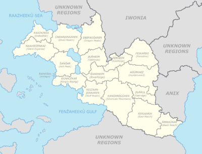
Keizaan, officially the United Provinces of Keizaan (Keizaani: Aaǧùkëzman eð Keizaan) is a country located in North-Eastern Hiraethia. It possesses no overseas regions or territories and is only composed of the mainland. Metropolitan Keizaan shares its borders with Iwonia to the north, Anix to the east and Sanxenxo to the south. The mainland extends from the north-western Raazheekù Sea to the south-eastern Talsar Sea. The entire country is 844,393 square kilometers or 326,021.96 square miles with an entire population of 14,354,681 as of July 2023. Keizaan is a federal directorial elective monarchy with its capital Fenẑahsaan in the Bay of Wind.
Keizaan's history starts about 600,000 years ago with the ancestors of the Keizaani people in the south-eastern parts of the current day Province of Blackreach as they evolved through the periods by moving towards the current day Province of East March and Province of Oakridge. What would be called the Early Ancient Period also known as Ƿeǧr Ðëmaǩar or "Clay Period", in around 9000 BCE, was when the first officially confirmed traces of the modern Keizaani people would be found in the southern Province of Silvervale Mountains, the Province of Wolf Realm and the Province of Huntersward, a lot of early settlements made up of clay and hay were discovered. About 300 years later the First Keizaani League is thought to have been established as an alliance of the multiple tribes around the Ash Peaks basin.
Agriculture started to appear by the 5th millenium BCE and as of the 3rd millenium BCE, metallurgy appeared along with other fields that helped develop the tribes as they started to form small tribal states. By the 4th century BCE, the outlines of the current provinces would appear on the map as most of them became independent states still trading with each other. The first Congress was held in 415 AD and the southern provinces allied into the Keizaani Republic until the 7th century AD, lasting for less than three centuries.
Geography
The entirety of Keizaan is situated in Central Hiraethia as the country doesn't possess any overseas dependencies. It is surrounded by Iwonia to the north, Sanxenxo to the south and Anix to the east on land, while on water it borders the Talsar Sea to the east, the Fenẑaheekù Gulf to the south-west and the Raazheekù Sea to the north-west.
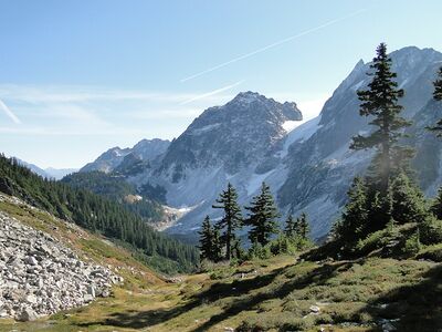
The entire country enjoys a temperate climate from north to south and east to west, the eastern Feikarðo Temperate Forest in the Province of Forestine (Feikarðo), the Province of Eastforge (Ǩerheim), Province of Huntersward (Aǧùrkaiz) and the Province of Oakridge (Ƿuŕǩul or Ƿuŕǩut) is the biggest forest in the entire country and supplies around 70% of the nation's wood supplies, a similar sort of forest exists near the Province of Blackreach but isn't as massive. Plains are also pretty common in the country, especially in the north-west around the Raazheekù Sea with the Province of Elven Realm, the Province of the Silent Expanse and the Province of Endwalker with the Raazvak Plains and the south-east around the Province of East March with the East March Plains. In the absolute north, center, south and central-west of the country, four mountain ranges, the first mountain ranger being the one in the east of the Province of Ash Peak with the volcanic Ash Peaks Mountain Range which is a very dense range spanning from the capital of the Province near its center to the Lake of the Elvenkin and the Lake of Kings. The second range resides in the Far Northern Region encompassing the Province of Dragon Peaks also known as "Keizaal" in Old Elvarin and a small area in the north of the Province of Oakforge, it ranks second in the highest mountain range, at an average of 4000 meters in height, it's also the coldest of all and least populated with a few Holds like Nightwatch and Grayhold respectively in the center and absolute north. This region is a pretty hard to access and closed up place that has the least amount of roads fit for cars and trucks as well as the least kilometers of rails, nearly every hold and town has a helicopter pad which is the best way to get people and goods in and out of the regions. The third range is located in the central-south in the Province of Silvervale Mountains also known as "Kandar" (Outer Heavens or Silver Valley), it spans the entire province from north to south and is the most populated mountain-province in the entire country. It was named "Silvervale" for its abundant silver ore deposits, it being the source of most of the armed forces' weaponry before the invention of guns. The fourth range is located in the heart of the country in the Three Forges Region, it's a pretty huge mountain chain in term of area but not in height, the highest peak being only 4371 meters high.
The country also possesses six main bays, the Capital Bay where the capital city lies, the King's Bay and Kovan Bay in the south of the Province of King's Rising, the Ghost Coast Bay (also known as Beak Bay) shared between the Province of Ash Peak and the Province of King's Rising, the fifth one is located in the south-central area of the Province of the Silent Expanse and is named the Lost Arch Bay named after the structure surrounding it, the sixth and last one is located west of the Raaz Peninsula in the Province of Endwalker, it being named the Kaerik Bay, after the Demi-God of Death Karik.
Keizaan's total area is roughly 844,393 square kilometers (or about 326,022 square miles), being nearly as big as Greater Efrafa but still smaller than Anavero. The highest peak of the country being the Avekward Peak in the Province of Dragon Peaks, at around 7201 meters, also called the "Resting Place of Avek".
Environment
Keizaan was one of the first countries with an environment-related government entity, it was officially created in 1731 by the 193rd Supreme Elder, it has been called the Department of the Environment and Wildlife Protection or the "DEWP" since its inception. Keizaan remains very lightly industrialized except in big cities where the architecture grew along with the technology. Cars are very limited and trains are predominant in the country, being the most common way of transport after helicopters and planes. The country function at 83% with electricity, produced from solar panels, dams, geothermal energies and windmills. Keizaan is the most environmentally cautious country in Anteria.
There are a total of 75 national parks around the country divided into multiple categories including the three main categories that are Maritime National Parks which take into account coral reefs, underwater structures and everything that concerns lakes, rivers and ocean, Mainland National Parks that encompass every mainland national parks that are mountainous, plains, forests or anything and Underground National Parks which are every national parks that count caves and ravines.
Climate
The climate of Keizaan is pretty favourable for agriculture and cultivation. The entirety of Keizaan is part of the northern temperate zone
Flora and fauna
Administrative divisions
Subdivisions
Demographics
Immigration
Religion
Language
Ethnic groups
Major cities
Education
Health
Government
Law
Foreign relations
Military
Economy
Infrastructure
Tourism
Energy
Transport
Trains
Planes and helicopters
Science and technology
Art
Architecture
Literature
Music
Cinema
Fashion
Media
Cuisine
Sports
See also


