Pelostan: Difference between revisions
mNo edit summary |
|||
| (16 intermediate revisions by one other user not shown) | |||
| Line 2: | Line 2: | ||
{{Infobox country | {{Infobox country | ||
|micronation = Yes | |micronation = Yes | ||
|conventional_long_name = The Citystate of Pelostan | |conventional_long_name = The Royal Citystate of Pelostan | ||
|native_name = Teplore le Pelostan | |native_name = Teplore le Pelostan | ||
|common_name = Pelostan | |common_name = Pelostan | ||
|status = Citystate | |status = Royal Citystate | ||
|image_flag = | |image_flag = New_Pelostan_Flag.png | ||
|alt_flag = <!--alt text for flag (text shown when pointer hovers over flag)--> | |alt_flag = <!--alt text for flag (text shown when pointer hovers over flag)--> | ||
|flag_border = | |flag_border = | ||
| Line 17: | Line 17: | ||
|national_motto = ⁶⁶Bitok Enu Le Kobev!₉₉ | |national_motto = ⁶⁶Bitok Enu Le Kobev!₉₉ | ||
|englishmotto = ⁶⁶Fight Until The End₉₉ | |englishmotto = ⁶⁶Fight Until The End₉₉ | ||
|national_anthem = | |national_anthem = Naczdy svonodny! (Forever free!) [[file:MediaPlayer.png|link=https://soundcloud.com/miroslav-bou-ek/naczdy-svonodny/s-NMQiiVcyw79]] | ||
|royal_anthem = <!--in inverted commas and wikilinked if link exists--> | |royal_anthem = <!--in inverted commas and wikilinked if link exists--> | ||
|other_symbol_type = <!--Use if a further symbol exists, e.g. hymn--> | |other_symbol_type = <!--Use if a further symbol exists, e.g. hymn--> | ||
|other_symbol = | |other_symbol = | ||
|image_map = | |image_map = Pelostan_Location2.png | ||
|loctext = <!--text description of location of country--> | |loctext = <!--text description of location of country--> | ||
|alt_map = <!--alt text for map--> | |alt_map = <!--alt text for map--> | ||
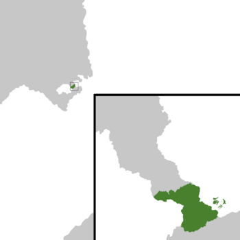
|map_caption = | |map_caption = Pelostan shown on the map. | ||
|image_map2 = | |image_map2 = Untitled231 20210918122912.png | ||
|alt_map2 = <!--alt text for second map--> | |alt_map2 = <!--alt text for second map--> | ||
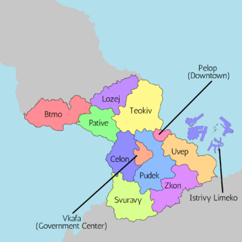
|map_caption2 = | |map_caption2 = A district map of Pelostan. | ||
|capital = <!--Name of country/territory's capital, wikilinked if link exists--> | |capital = <!--Name of country/territory's capital, wikilinked if link exists--> | ||
|coordinates = <!-- Coordinates for capital, using {{tl|coord}} --> | |coordinates = <!-- Coordinates for capital, using {{tl|coord}} --> | ||
| Line 42: | Line 42: | ||
|languages2 = <!--Languages of this second further type--> | |languages2 = <!--Languages of this second further type--> | ||
|languages2_sub = <!--Is the second alternative type of languages a sub-item of the previous non-sub type? ("yes" or "no")--> | |languages2_sub = <!--Is the second alternative type of languages a sub-item of the previous non-sub type? ("yes" or "no")--> | ||
|ethnic_groups = | |ethnic_groups = | ||
|ethnic_groups_year = 2019 | |ethnic_groups_year = 2019 | ||
|ethnic_groups_ref = <!--(for any ref/s to associate with ethnic groups data)--> | |ethnic_groups_ref = <!--(for any ref/s to associate with ethnic groups data)--> | ||
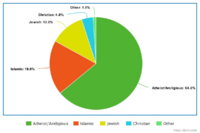
|religion = | |religion = [[File:Pelostan Religion.png|200x200px|frameless]] | ||
|religion_year = 2019 | |religion_year = 2019 | ||
|religion_ref = <!--(for any ref/s to associate with religion data)--> | |religion_ref = <!--(for any ref/s to associate with religion data)--> | ||
| Line 69: | Line 69: | ||
|area_rank = | |area_rank = | ||
|area = | |area = | ||
|area_km2 = | |area_km2 = 545 | ||
|area_sq_mi = | |area_sq_mi = 210 | ||
|area_footnote = <!--Optional footnote for area--> | |area_footnote = <!--Optional footnote for area--> | ||
|percent_water = 3.5% | |percent_water = 3.5% | ||
| Line 100: | Line 100: | ||
|Gini_year = 2021 | |Gini_year = 2021 | ||
|HDI_year = 2021 | |HDI_year = 2021 | ||
|HDI = 0. | |HDI = 0.98506 | ||
|HDI_change = Increase | |HDI_change = Increase | ||
|HDI_rank = | |HDI_rank = | ||
| Line 142: | Line 142: | ||
=== The 1968 expansion=== | === The 1968 expansion=== | ||
In the year of 1968, the decision to expand was made, leading to 19 years of expansion, which had covered all of what is nowdays Pelostan. | In the year of 1968, the decision to expand was made, leading to 19 years of expansion, which had covered all of what is nowdays Pelostan. | ||
=Politics= | =Politics & Government= | ||
==Foreign Relations== | ==Foreign Relations== | ||
== | {| class="wikitable sortable collapsible" | ||
! width=120px|Country/Union/Autonomous District | |||
[[File:Elisabeth Birgirsdottír.jpg| | ! Status | ||
! State of relations | |||
! Mutual Embassies | |||
! Formal Relations Began | |||
! Pelostani Ambassador | |||
! Foreign Ambassador | |||
|- | |||
| | |||
[[File:Flag of Blechingia.png|50px]] [[Kingdom of Blechingia|Blechingia]] | |||
| bgcolor = green | Good. | |||
| Trade Partners. | |||
| bgcolor = grey | TBA. | |||
| 18th October 1993. | |||
| [[File:Elo Nuvak.png|120x120px|frameless|Elo Nuvak]] | |||
Elo Nuvak | |||
| [[File:Elisabeth Birgirsdottír.jpg|120x120px|frameless|Elisabeth Birgirsdottír]] Elisabeth Birgirsdottír | |||
|- | |||
|} | |||
{{Template:Anteria info pages}} | {{Template:Anteria info pages}} | ||
[[Category:Anteria]] | [[Category:Anteria]][[Category:Countries in Anteria]] | ||
Latest revision as of 09:24, 21 August 2022
This article is incomplete because it is pending further input from participants, or it is a work-in-progress by one author. Please comment on this article's talk page to share your input, comments and questions. Note: To contribute to this article, you may need to seek help from the author(s) of this page. |
The Royal Citystate of Pelostan Teplore le Pelostan | |
|---|---|
|
Flag | |
| Motto: ⁶⁶Bitok Enu Le Kobev!₉₉ ⁶⁶Fight Until The End₉₉ | |
| Anthem: Naczdy svonodny! (Forever free!) | |
 Pelostan shown on the map. | |
 A district map of Pelostan. | |
| Status | Royal Citystate |
| Official languages | Pelostani |
| Recognised regional languages | Relopik, Ozite |
| Religion (2019) |  |
| Demonym(s) | Pelostani |
| Government | Federal Parliamentary Constitutional Citystate |
• President | Pelof Belovie |
• Vice President | Nelo Vip |
• Head of Parliament | Gole Herno |
| Legislature | Parliament |
| Senate | |
| Chamber of Deputies | |
| Establishment | |
• Founding of Pelostan | 1946 |
| Area | |
• | 545 km2 (210 sq mi) |
• Water (%) | 3.5% |
| Population | |
• 2021 estimate | 5,924,347 |
• 2019 census | 5,892,314 |
• Density | 6,627/km2 (17,163.9/sq mi) |
| GDP (PPP) | 2021 estimate |
• Total | 334,304,976,863 |
• Per capita | 56,492 |
| GDP (nominal) | 2021 estimate |
• Total | 351,586,297,062 |
• Per capita | 59,346 |
| Gini (2021) | 0.49 low |
| HDI (2021) | 0.98506 very high |
• Summer (DST) | UTC+2 |
| Driving side | right |
| Calling code | +68 |
| Internet TLD | .ps |
The Citystate of Pelostan is a tiny citystate nation, with a total population of 5,924,347 residents. The nation was founded by Iloper Netoj. Pelostan acts as a major business hub and tourist attraction in Anteria.
History
Viking Age
Before the foundation of modern day Pelostan, the land was inhabited by vikings.
The vikings were cruel rulers, as any dissobediance is was met with saddist punishements, such as: slicing off a toe finger, poking an eyeball out, being stripped naked and stoned in public, etc.
Evidence to proove the inhabitence by vikings, are traditional fairytales & drawings. One of these fairytales, named Role I Foper is still commonly spread to this day.
Foundation of modern Pelostan
The Citystate of Pelostan was founded on the 28. 7. 1946. It was founded by a group of 120 refugees escaping civil war from a now non-existent country. The refugees were looking either to find a nation that will let them stay, or found a new nation. There was a low chance of them being accepted into an already existing country, as (at that time) the people from their country were seen as terrorists, murderers and robbers. After 3 days on the sea, they stumbled actoss the land, which is nowdays Pelop, deciding to stay there.
The 1950 expansion
After 4 years of inhabiting the same land, the people had decided to expand to the surrounding area. The expansion had taken 10 years, as the terrain was at that time full of rain forests. The expansion had covered all of Teokiv and a majority of Pudek and Uvep.
The 1968 expansion
In the year of 1968, the decision to expand was made, leading to 19 years of expansion, which had covered all of what is nowdays Pelostan.
Politics & Government
Foreign Relations


