Gregoria: Difference between revisions
No edit summary |
No edit summary |
||
| Line 149: | Line 149: | ||
==History== | ==History== | ||
{{main|History of Gregoria}} | |||
==Politics== | ==Politics== | ||
==Government and Military== | ==Government and Military== | ||
Revision as of 16:29, 9 May 2022
Evardom of Gregoria გრიგორიის ევარდომი (Gregorian) | |
|---|---|
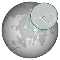
 Gregoria's Location in Thrismari. | |
| Capital and | Ananuri |
| Official languages | Gregorian |
| Demonym(s) | Gregorian |
| Government | Unitary parliamentary constitutional monarchy |
• Evar | Alexei IV |
• Prime-Minister | Kira Kobalia |
• Evarwifia | Eva Alavidze |
| Population | |
• 2022 estimate | 6,440,000 |
• 2020 census | 6,432,332 |
Gregoria (Gregorian:გრიგორიის ევარდომი) officially the Evardom of Gregoria is a country in west-central Thrismari, landlocked and surrounded by Encessia to the north and Lyttohnstan to the south. The nation is located exclusively within the Narinjinsperi Mountain Range, giving the nation a rough but naturally beautiful climate. Gregoria has a total land area of x km^2, making it one of the smallest countries in continental Thrismari.
The Evardom has a population of around 6.4 million people. The population is fairly sparsley urbanised, with a population density of around x/km2 (x/sq mi). Gregoria is a constitutional monarchy headed by the Evar of Gregoria.
Etymology
The name 'Gregoria' derives from the patron saint of Gregoria, Saint Gregory, who founded the nation and established the beginning of recorded history within the mountain enclave. It became the name of the nation in 1566, however, replacing Tsilori due to a legal documentation signed by the Evar that gave the land the name 'Gregoria' which is believed to be for the ease of Common speakers.
Geography
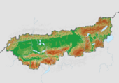
Gregoria is located in the southern regions of the Narinjinsperi Mountain Range that stretch from southerb Encessia into central Lyttohnstan. The mountains surround Gregoria, giving it an alpine climate. Gregoria encompasses a great diversity of landscapes and climates on a limited area of xkm^2 (x square miles). The nations population is around 6.4 million people (2021 estimate). Gregoria has an estimated population density of x people per km2 (x/sq mi). In the largest canton, Tskhami, the population density falls to around 13 people per km2.
The nation lies entirely within the -2 timezone, on the same latitude as nations such as Alamtar and Aisharia and the same longitude as nations such as the Ganji Islands and Foxomexra. It contains three basic topographical areas: the Gregorian Narinjinsperi to the south, the Gregorian Plateau or Western Plateau, and the Sera mountains on the east. The Narinjinsperis are a high mountain range running across the north, west, south and some of the east of the country, constituting about 70% of the country's total area. The large majority of the nations citizens live in the Gregorian Plateau region. Among the high valleys of the Gregorian Narinjinsperi, many glaciers are found, totalling an area of 806 square kilometres (311 sq mi). From these originate the headwaters of several major rivers, such as the Gortanula, Inna, Pzilrua and Rhône, which flow in the four cardinal directions into the whole of Europe.
History
Politics
Government and Military
Economy
Culture
Architecture and Arts
Media
Music
Cuisine
Ski Culture
Sports
See Also
Notes
References


