Urban Transit in Riamo

The term Urban Transit in Riamo refers to the various urban transportation and mass transit systems across the Riamese Federation. With a history of major developments in the transportation field, Riamo became a major railroad nation by the turn of the 20th century, closely tying the history of railroads in Riamo with the history of rail transportation across Anteria.
History

With the first global metropolitan railway opening in Guri by 1880, Riamo soon ascended to become the most advanced railway operator worldwide. The nation, which possessed notable coal and iron deposits along the Leight river, was quick to join the trend of 'railwayisation' across its territory, opening numerous lines between 1880 and 1908 with financial aid of both public and private sectors, the most important of which became the Guri Metropolitan Railway, today part of the Guri Metro; the first undeground urban railway in history.
The Guri Metropolitan Railway, which aimed to take underground some of the urban surface traffic congestion, started a revolution that would lead to the creation of a new mode of transportation adopsted across the globe: the subway.
This mode of transit, popularized across the main urban centers of Riamo by the end of the 10th century, would only materialize in 2 other riamese cities by the end of the century: Portington's subway, which started operations soon after, in 1892, and Nammington's, doing so by 1901 as well. However, due to the Great War, further projects would be put on hold, but during the first decades of the century, and because of their much proven success, another 3 Riamese century-old systems would follow behind, those being Nashe's (1903), Crosston's (1914), and Redport's (1915).
By the war's end, and with most cities in the post-war reconstruction process, funding for these transit projects intensified, looking to attract a new urbanistic model capable of handling the rising riamese population. It would be from these ideas that trenchways would eventually come from, bringing with it an ever-increasing population support for urban transit, and with it, models that would culminate into the well-known riamese transit dependency.
After the Great War reconstruction efforts, and with city councils jumping into this railfaner trend, tram and subway systems started opening across Riamo, with more than 277 cities having either of them by 1960.
Nowadays, Riamo possesses the largest amount of subway systems, subway lines, lenght of national railways, and daily urban transit ridership across the globe, with a deep-rooted transit culture and a well-extended populational support for transit systems.
Guri

Known for the Guri Underground, the first metropolitan railway in the world, the Guri Metropolitan Area features the largest urban transportation network in Anteria. The system operates more than 30 lines and features all methods of urban transit to be known, including trenchways, subways, tramways, ropeways, a monorail express line to the airport, and an urban ferry system, nicknamed "waterbuses".
Portington
Main Article: Portington Urban Transit
By the late 1880s it had become clear that the city of Portington was receiving a large influx of new inhabitants, many from the upper valley, but many from surrounding areas too.
Innaugurated in 1892 in hopes to alleviate surface traffic, the Portington Subway linked the eastern and western halves of Central Portington in a 1.7km segment with only 4 stops. While only managing to catch a rough 7000 passengers for the end of the first month, the subway quickly became a resounding success comparable to that of Guri's, gathering interest at the local and regional level. By 1900, and having managed to secure funding from the local government, the Subway soon expanded north towards Riamo Station, in Westangle.
By 1904 the second line would open to connect the central city with the first rows blocks around it, being further extended by 1906. [1][2].
During the Great War lines ceased operation and were instead used as shelters, as the whole system went into lockdown and tunnels were perpetually used as such. After the war was over, and with better funding, the system reopened and works regarding the third line, now blue Line, continued. Excavations reached Flower's Avenue (1918) and the Diagonal Avenue (1920), and after some final works, the line opened by 1921, with interchange stations having to wait until 1922.
By 1925, line 4 opens linking yellow and blue lines with a short 4-stop path, and was quickly enlarged east, reaching Republic Square (1927); and west, reaching Riamo Station (1930)[3].
By the 1940s, the city of Portington was well on its way to complete a large grid of several paralel roads, which had been planned from the 1920s, and whose aim was to unite the 6 former towns that today make up Portington, following an efficient and organized urbanistic approach.
In an effort to further formalize the grid, the Diagonal Railway (later Trenchway line orange) would open in 1936[4], also linking with north Grasston and Barren by 1940[5][6].
After the resounding success of orange trenchway line, several polls were made from the townhall, giving the citizens an opportunity to choose between several transit ideas from at least 5 different architectonic studios. This lead to the development of several more Trenchway lines along poorly-used long-distance rail corridors, notably, The Marine line, which linked East Gate with Junlesse and Oakley through the Marina, creating the now known "Parliament Rotonde".
By this time, the townhall had assembled a large project for the metropolitan area's transit, commonly nicknamed "The 1940 Grid Plan", but elections soon after would give the power to opposers of the plan. Plans changed, and some lines were rerouted. Blue subway line eventually reached Nordille by 1940, instead of the yellow line, which was instead exteded north, and by 1942 opened at Saints Station, where the red line would have gone, but was instead extended to Farrington, opening later that year.

By 1944, excavations for the red-orange interchange station (today Parkville station) were proving to be particularly difficult, given the depth of the tunnels were particularly deep as well. On September 2nd, 1944, a particularly strong rain fell on the city. Human error and a series of faulty equipment lead to a discharge of rainwater into the orange line under construction tunnels, which hadn't been installed much of its safety equipment yet. The tunnels, still unconnected from the rest of the system, had not been casted into a solid tunnel structure, but were in fact a ~102 meter-long openings of exposed rock. This all lead to the flodding of the partially-excavated southbound tunnels, which collapsed into a sinkhole at 12:07. To this day, it is unknown how many workers were in the tunnels at the time, but it is estimated 45 personnel were trapped into the collapsing tunnels, with only 3 of being rescued alive.

This accident, known as the Parkville Bend Accident, lead to a Day of National Sorrow as with many important accident in Riamo. Most of the areas affected by the sinkhole, as well as those that eventually got flooded by rainwater (mostly from broken pipes), were designated as not rigid enough for construction, and urbanization was prohibited. This forced the Portington-Bielton highway, then under construction as well, to be deviated east near Parkville. Parkville Station was redesigned following the disaster, mainly as a homage to the victims and their unknown resiting place, turning the initially small station into what would become the transportation hub of northern Portington. The plan also incuded the creation of a memorial park, with a shrine being installed in place where the sinkhole is thought to have originated. Plans were laid for Trenchway routes to pass through the station, setting the stage for the Circumvent Rail Corridor to eventually open a decade later, which would latter create a natural rail ring north of the city. By 1948 the new station opened, and by 1949 it was linked to the Tramnord tramway network.

By this time, tramways became widely used, the most notorious being Oakley's Oaktram, Barren's Eastram, Barrenlow's Barrentram, Greenhill's Greenway, and Junlesse's Juniper transit. All of these would go near bankrupt along the 70s, but ultimately survived into the 20th century via public-private funding and cooperation.[7]
In 1948, Riamo Station, Saints Station and East Gate are formalized as the 3 long-distance stations of the city, and a large amount of additional regional Trenchway services started soon operating from them[4]. From Riamo Station, trains reaches Oakley and Watterpon; from Saints start operating trains into the upper valley (including Halshire and Pandeltown); and from East Gate trains start operating in the new coastal Barrenlow Corridor via Barrenlow-Arrendale.
From 1948 to 1960, 3 more subway lines would open. In the far north, a...
With the arrival of the arrival of the Federation, the system saw a massive influx of public funding starting in 1978. The expansions of the system past this time started to happen multiple times a year, and station-by-station, at an unprecedented rate, with multiple modifications of preexisting lines being made possible because to the system's universal gauge and electrification, as well as the multiple underground crossings and interconnections preplanned into it[4].
By the late 70s and 80s, the Metropolitan Railway company was seeing a steep increase in revenue and riders, which lead to many upgrades in the system, specially in the shape of a refurbishment of several century-old corridors, many of which saw complete remakes of tunnels and junctions that forced to deviate lines for months or even years. Some of the new additions to the system were lines brown, turquoise, and maroon, Westmount's Cable car, the airport's interterminal monorail, 2 of Greenhill's cable car lines, and the famous Riamo-East Gate rail tunnel, a project which links Riamo and East Gate stations underground through a tunnel parallel to the green subway line. Soon after, regional Trenchway train services were reorganized following multiple network upgrades and extensions, with the former 4 lines becoming 9. By year 2000, the system would have 8 subway lines, 10 trenchway regional lines, and more than 10 tramway and ropeway lines.
By 1983, the red line would be finally connected with its northernmost half, a project in the works for almost a decade by then. This connection, seen by many as a mistake, created a direct transit corridor between the towns of Watterpon-Junlesse and Portington proper, and was soon to become the most crowded line in the system by 1990. By 1995, an idea which envisioned the creation of an underground trenchway corridor linking the 2 towns would be popularized by local majors. While it took another decade to be completed due to the lack of incentive by the Metropolitan Railway Company, the development incentivized by the line would be, at the time, one of the largest in terms of revenue for the company.


As 2002 came, the system suffered a major line restructuration that saw the renovation of several stations previously located in curves. This overhall also saw the reincorporation of the Docks-Princess tunnel to the system, as part of the newer version of the ring line, previously closed to public access in 1980 (the yellow line's branch had been transfered to the then new purple line as to avoid track sharing). By that year, the company took a turn for new developments, starting to overlap lines even in non-doubled track segments when considered beneficial, something that had been continuously been avoided before, and had lead to many unique concepts being created as consequence.[4]
The reworking of the circle line sparkled a lot of controversy mid-project, leading to a popular vote in 2002 that chose a route with no curve stations, via the Docks-Princess tunnel, connecting to Riamo station by track-sharing with the purple line, taking the green line's Riamo-Saints tunnel, and then continuing north past the Diagonal Avenue until reaching the other end of the line near Grasston. The other 2 branches of the former yellow line became the newer version of the purple line, which would eventually be completely separated from the yellow with the Central West corridor in 2007, linking the 2 former branches through a different parth directly underneath the city center.
By 2007 the orange line had been fully extended to reach the seashore at Shellytown, reaching the rouristical town of Beachfort by 2009.
By 2020, another set of projects would arise once again, including innumerable upgrade ideas for many stations. One of these, Grasston station (Also known as Grasston Central) would see a massive urbanistical remake of several road blocks by 2025, which would see the construction of a northern CBD district in plain Portington city.

Trenchway 449 Series (5-1 Configuration)

Nashton
Originally intended as a small, quality system meant to aid the small city's crowded streets, Nashton's subway system was more of a tramway network than that of a subway proper. Starting operations in 1903, the system soon expanded to have 12 lines across the city by the start of the Great War, point by which it went into a small decline given the circumstances.
After the war, and with large waves of immigrants slowly turning the former village into a large city, the system soon expanded into Victoria Harbour (1920), Southon (1922), and West Island (1929). The electric revolution started by 1944, with lines being upgraded to accomodate for larger, more modern, electric-powered, multi-axial trams.
By 1949 the system reached an all-time-high line count of 49 lines, reaching peripheral towns like Barracks and Tumblewood, and with local government preventing urban development in much of what was considered "green spaces" of the rugged terrain, population density started to rise steeply throughout the decade.
The 50s and 60s scame with a lack of funding for the system, which combined with the ever-increasing traffic jams, longer journeys, and poor service quality, deriving in declining ridership and revenue that brought the company to almost filing bankruptcy, being partially bought by the local government to be incorporated into United Trenchways in 1963.
Starting that year, the business model of the company swiftly changed, slowly starting projects for the construction of 2 subway lines in downtown Nashton, which were built by 1969, year by which Alexander Ferrier was put as head of the organization, who promoted a policy of including the lease of real state as part of the company's model.
By 1975, and with the company making profit and slowly paying its debts, the so-called Ferrier System would be trialed in cities like Watergate and Portington, where they were eventually completely implemented.
By 1976, line 3 would be innaugurated traversing Victoria Port's canal, linking the 2 large parts of the city, and slowly expanding outwards, with line 4 coming by 1882, and line 5 by 1987.
The system, which today encompasses the main, and, essentially, sole method of transportation of the city, is used by over 2 million daily commuters. While it has been qualified as the system with the highest revenue per kilometer of built rail in the world, its business model has been critizised for its ethics, said to have started a nation-wide housing crisis, as well as a Transit-dependent society across the nation.
Redport
With the war leaving most of the city absolutely destroyed, the post-war period saw the re-urbanization of a vast majority of the city, turning new developments into a grid-like street pattern that followed the idea behind Portington's urban design. With the model implemented, the city's first subway line opened by 1915, linking both sides of the river with the Opera house, the Grand Catedral and the Naval Museum.
Lines soon expanded to cover a large portion of the old city, and with the urban area soon growing to a metropolis,
Gallery
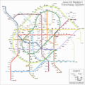
Portington Subway System in June 2022
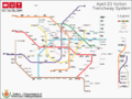
Volton Subway system in late 2022


Read more
References
- ↑ First lines. Metropolitan Railway Company. Retrieved June 15, 2022.
- ↑ About us. Metropolitan Railway Company. Retrieved June 15, 2022.
- ↑ Study on Portington's Urbanism by Joe Markston. Retrieved June 15, 2022.
- ↑ 4.0 4.1 4.2 4.3 Almondy, Joe. History on Riamese Railways.
- ↑ Republic Square's Station. Web Archives of the Metropolitan Railway Company. Retrieved June 15, 2022.
- ↑ Barren's history and geography, volume I by Hamilton Shelton. Retrieved June 15, 2022.
- ↑ Iqe, Pagei, A. A resume of the Riamese Transportation Culture, p.102
External links
Currently, there are 953 pages associated to Anteria | |||||||||||
| History |
| ||||||||||
| Legal status of | |||||||||||
| Culture | |||||||||||
| Society and Demographics | |||||||||||
| Economics | |||||||||||
| Geography |
| ||||||||||
| Government | |||||||||||
| International organizations |
| ||||||||||
| Sporting Unions | |||||||||||
| Institutions | |||||||
|---|---|---|---|---|---|---|---|
| Geography & Geology |
| ||||||
| History |
| ||||||
| Culture |
| ||||||
| People |
| ||||||
Part of Anteria Universe lore | |||||||