Thuadia: Difference between revisions
Native Qazh (talk | contribs) |
Native Qazh (talk | contribs) |
||
| Line 110: | Line 110: | ||
| style="text-align:center"| [[File:Coat of Arms Qazhshava.png|50px|frameless]] | | style="text-align:center"| [[File:Coat of Arms Qazhshava.png|50px|frameless]] | ||
| style="text-align:center"| [[Qazhshava]]<br>([[Samyr language|Samyr]]: Пӗрӗхҫин Каҫҫава'нӑн) | | style="text-align:center"| [[Qazhshava]]<br>([[Samyr language|Samyr]]: Пӗрӗхҫин Каҫҫава'нӑн) | ||
| style="text-align:center"| [[Samyr language|Samyr]] | | style="text-align:center"| [[Samyr language|Samyr]], [[Bisveni Language|Bisveni]], [[Pustogorian Bogmian language|Bogmian]], [[Kodin language|Kodin]],<br>[[Lakkathan language|Lakkathan]], [[Louzen language|Louzenish]], [[Bornese languages|Padlian]], [[New Sebronia#Sebric|Sebric]],<br>[[Tayamo language|Tayamo]], {{wp|Surzhyk|Tiskai}}, {{wp|Bulgarian|Vranic}}, [[Veltic language|Veltic]] | ||
| style="text-align:center"| 1,467,137 | | style="text-align:center"| 1,467,137 | ||
| style="text-align:center"| 82,109,690 | | style="text-align:center"| 82,109,690 | ||
Revision as of 21:47, 12 February 2022
This article is incomplete because it is pending further input from participants, or it is a work-in-progress by one author. Please comment on this article's talk page to share your input, comments and questions. Note: To contribute to this article, you may need to seek help from the author(s) of this page. |
 | |
| Area | 50,592,305.17 km2 (19,533,798.23 sq mi) (1st) |
|---|---|
| Population | TBD |
| Population density | TBD |
| GDP (nominal) | TBD |
| GDP (PPP) | TBD |
| GDP per capita | TBD |
| HDI | TBD |
| Ethnic groups | |
| Religions | |
| Demonym | Thuadian |
| Countries | 62 |
| Languages | |
| Time zones | UTC -11 to 0 |
| Internet TLD | .th |
| Calling code | +1, +3, +7 |
| Largest cities | Largest urban areas:
|
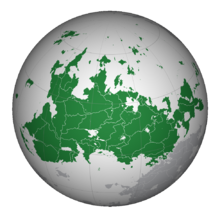
Thuadia is a Continent in Western Anteria, making up the Northern part of the wider Thuado-Thrismaria landmass. Stretching from around 170°W to around 10°E, Thuadia is Anteria's largest continent, clocking in at 50.6 million kilometers squared. It is bordered by the Rimidic Ocean to the north, the Paisi Ocean to the west, the Hagalaz Ocean and Thrismari to the south and the Sunadic Ocean to the east. Thuadia is separated from Thrismari by the the waterways of the Dagatai Sea, Madak Strait and the Canton canal.
Etymology
History
Thuadia was the second continent to be inhabited after Thrismarian humans arrived from Central Thrismari. After multiple decades, humans spread to almost every area of the continent and the first settlements were established. One of the first of these were the Proto-Guurissi in modern-day Neuewland, who have existed there since 9000 BCE, and the Botenik Hunter-Gatherer culture in modern day Kentalis, who date back to around 15,000 BCE. One of the first cities established on Thuadia was the ancient city of Kjun in modern day southern Kiyortza in the fourth millenium BCE. The first nation established was in modern Senefpat, which existed from 2500~ BCE. Christianity was introduced to the continent by missionaries from Silvadum around 300 AD, and spread across the continent quickly, beating out folk religions across southern and central Thuadia. 499 AD saw the beginning of the Jovanist split from the main Orthodox churches of Thuadia, establishing Jovanist Orthodoxism as a seperate religion. Thuadia was home to many medieval states and kingdoms, which lasted from 550 AD up to 1450 AD, when changes in the wider mentality caused many of these states and the catholic church to need reform, together with the introduction of gunpowder. Technological advances were made from 1450 forward in the Thuadian Technological Reborning, and contact with the Eastern continents of Astirax and Olivacia was beginning to become more common. Thuadia was home to the main colonial empires of Anteria, which mainly colonised Thrismari.
From the 1590s upwards, Thuadian nations started colonising parts of Thrismari and Astirax. One of the main colonisers was the Canterian Empire, while smaller regional empires included the Neuew empire. In the 1610s, the kingdom of Požanovac, one of the largest regional empires in southern Thuadia, collapsed, causing chaos across the southern part of the continent, especially the Laurentine Gulf area. 1773 saw the Empire of Three Kings formed in Mustelaria, and in the mid 1800s the Požanovac peninsula was re-united. Following the invention of the steam engine, many nations across Thuadia started industrialising. From 1905 to 1911, the Great War was fought across the entirity of Anteria, with many fronts and the start of the war taking place in Thuadia. During the Era of Civil Wars, many Thuadian nations, including Zhousheng and Kentalis, saw civil unrest. Following the Turn of the Century, the continent has stabilised, and with the exception of Vescarium, has been relatively peaceful.
Geography
Countries
Listed below are all countries located on the continent of Thuadia as of 2022.
| Flag | Arms | Name | Official language | Area (km2) |
Population | Population density (per km2) |
Capital |
|---|---|---|---|---|---|---|---|
| Kentalis
(Kental: Република Кенталис) |
Kental, Ereskanese, Bisveni and Arakovac | 759,872 | 65,843,589 | 86.8 | Polácica | ||
| TBA | Kiyortza
(Keijasi: Dijavn Kijorcani) |
Keijasi, Rijaki, Ikari, Norita, Rukoči, Žinasi, Lorfier, and Ifarszi |
1,657,269 | 194,416,610 | 118.26 | Kyrisje | |
| Qazhshava (Samyr: Пӗрӗхҫин Каҫҫава'нӑн) |
Samyr, Bisveni, Bogmian, Kodin, Lakkathan, Louzenish, Padlian, Sebric, Tayamo, Tiskai, Vranic, Veltic |
1,467,137 | 82,109,690 | 55.96 | Karakach |