Melasia
Federal Republic of Melasia Norwegian: Forbundsrepublikken Melasia | |
|---|---|
| Motto: Styrke og enhet (Norwegian) Strength and unity | |
| Anthem: TBA
TBA TBA | |
 | |
| Capital and largest city | Jørgenshavn |
| Official languages | Norwegian |
| Recognised national languages | See National languages in Melasia |
| Ethnic groups (2018) | TBD |
| Religion | Various |
| Demonym(s) | Melasian |
| Government | Federal constitutional parliamentary republic |
• President | Gustaf Sorbo |
• Prime Minister | Eirik Bradt |
| Legislature | Parliament |
| Senate | |
| House of Representatives | |
| Independence from the UKL | |
| 31 January 1904 | |
| 13 May 1913 | |
| 1-16 June 1967 | |
• Current Constitution | 11 November, 1967 |
• Water (%) | 13.8 |
| Population | |
• September 2020 estimate | 22,872,511 (42) |
• June 2019 census | 22,983,117 |
| GDP (PPP) | 2019 estimate |
• Total | $1.31 trillion |
• Per capita | $56,915 |
| GDP (nominal) | 2019 estimate |
• Total | $1.26 trillion |
• Per capita | $54,722 |
| Gini (2018) | 34.7 medium |
| HDI (2017) | 0.921 very high |
| Currency | krona (Kr) |
| Time zone | AST +8 to +9 |
| Date format | dd-mm-yyyy |
| Driving side | right |
| Calling code | +375 |
| ISO 3166 code | ME |
| Internet TLD | .me |
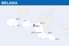
Melasia, officially the Federal Republic of Melasia (Norwegian:Forbundsrepublikken Melasia), is a country in western Savai. At idk square kilometres (idk sq mi), Melasia is the nth largest country in the world by area, and the xth most populous, with slightly below 23 million people living in the country as of 2019. Melasia's capital and largest city, Jørgenshavn, is the largest city in the country and a major port on the sea route between Catai and Asura, situated in the Pulau strait between the Manatan sea and the Southern Catai sea; other major cities include Grønnek, Nykirke, Buktgård, Lykkefort, Eiriksgård, Østerkirk and Sølborg. The territory of the country is situated within the AST +8 to +9 time zones.
Melasia consists of 3 major islands of the Savai arhipelago, as well as up to 350 small and volcanic islands in the Manatan, Saba and the South Cataian seas. The western Savaian archipelago is formed on the border between the Cataian and Savaian plates. The area is still seismologically active, which leads to frequent earthquakes, tsunamis and volcanic erruptions, especially in the Manatan sea. This area is considered one of the most dangerous ones in the world. The territory of the country is located close to the equator and is relatively flat, which makes it exposed to monsoons. Almost all of the territory of the country is covered by rainforests and is located within the tropical rainforest climate region.
It is confirmed that various tribes have crossed the strait between Catai and Western Savai as early as 2200 BCE. The first documented civilizations date from the 1800 BCE. As suggested by its geographical location, the islands of modern-day Melasia played a vital role in ancient and medieval naval trade between the east and the west. Melasian tribes were known as excellent sailors, and evidences of their expeditions can be found around the Savai archipelago and as far as southern Catai. During the Middle ages the area was heavily influenced by various Cataian nations. Until the 19th century the area was never unified under one flag, with parts of the islands in strategic locations being owned by more powerful Cataian empires, with the rest of modern-day Melasia being divided among various feudals, tribal alliances and isolated communities.
The islands were first discovered by Asurans in the 17th century. The first colonial empire to aquire full control over the territory of modern-day Melasia was the United Kingdom of Lhedwin in 1804. After a series of conflicts between the Asuran colonizers and the local warlords, the Crown Colony of Lhedwinic Savai was formed in 1823. Melasia as a concept arose after the Great Asuran War, when the area experienced a rise of national identity among its native peoples. Due to rising internal tensions, the colony was given increased autonomy from its metropole following a number of reforms between 1905-1912, and declared indepence in 1913. Following a severe economical crisis and unsuccessful political reforms in the late 1960s, the country experienced a revolution in 1967, when its government was disbanded and the presidend Salemon Ljungberg was imprisoned. Melasia constructed a stable liberal democratic political system over the course of forty years, slowly rebuilding its economy. Today Melasia is a federation consisting of 6 states and 4 autonomous territories.
Hafar is considered a minor power in Arabekh and has a nominal GDP of $92.8 billion, one of the lowest in the region. The country has a mixed economy that is completely dependent on fossil fuel exports, and relies heavily on exports into Asuran states, especially Midrasia. Primary exports include unrefined petroleum, copper, cotton, civil vehicles and construction materials. Agriculture is poorly developed, mostly because of the harsh weather conditions on most of territory of Hafar. The country has a nominal GDP per capita of $9,460.9, scoring well above the regional level. The national currency is the Hafari dirham. Hafar is the founding member of the Council of Fossil Fuel Exporting Countries.


