Riamo: Difference between revisions
No edit summary |
|||
| (87 intermediate revisions by 4 users not shown) | |||
| Line 1: | Line 1: | ||
{{Infobox country | {{Infobox country | ||
|conventional_long_name = Riamese Federation | |conventional_long_name = Riamese Federation | ||
|native_name = | |native_name = | ||
{{collapsible list | {{collapsible list | ||
| titlestyle = background:transparent;line-height:normal;font-size:75%; | | titlestyle = background:transparent;line-height:normal;font-size:75%; | ||
| title = Other: | | title = Other: | ||
| {{Infobox |subbox=yes |bodystyle=font-size:77%;font-weight:normal; | | {{Infobox |subbox=yes |bodystyle=font-size:77%;font-weight:normal; | ||
| rowclass1 = mergedrow | label1 = [[ | | rowclass1 = mergedrow | label1 = [[wikipedia:English|Spanish]]: | ||
| data1 = ''{{color|#00005A| | | data1 = ''{{color|#00005A|Federación de Riamo}}'' | ||
| rowclass2 = mergedrow | label2 = [ | | rowclass2 = mergedrow | label2 = [[Gallese Language|Gallese]]: | ||
| | | data2 = ''{{color|#00005A|Riamosze Federativa}}'' | ||
| rowclass3 = mergedrow | label3 = [[Namese language|Namese]]: | |||
| data3 = ''{{color|#00005A|Riamesze Federatona}}'' | |||
| rowclass4 = mergedrow | label4 = [[wikipedia:Spanish|Gavrilian]]: | |||
| data4 = ''{{color|#00005A|Riamesze Federatona}}'' | |||
| rowclass5 = mergedrow | label5 = [[Freice|Freician]]: | |||
| data5 = ''{{color|#00005A|Landua Kahe Ramio}}'' | |||
}} | }} | ||
}} | }} | ||
| Line 18: | Line 24: | ||
|image_coat = File:Emblem of Riamo.png | |image_coat = File:Emblem of Riamo.png | ||
|symbol_type = Seal | |symbol_type = Seal | ||
|image_map = File:Map | |image_map = File:Riamo Globe Map.png | ||
| image_map_size = | | image_map_size = 251px | ||
| map_caption = Location of Riamo (green). | | map_caption = Location of Riamo (green) and the Unhak Island Territories (circled). | ||
|national_motto = " | | image_map2 = [[File:Map of Riamese territories.png|251px]] | ||
| map_caption2 = Location of the Riamese Federation and its external territories: non-contiguous overseas territories (circled) and and the Unhak Condominium (pink). | |||
|national_motto = "Strength in Unity" | |||
|languages_type = {{wp|De facto}} [[wikipedia:National language|national language]] | |languages_type = {{wp|De facto}} [[wikipedia:National language|national language]] | ||
|languages = [[wikipedia:English|Common]] | |languages = [[wikipedia:English|Common]] | ||
| Line 27: | Line 35: | ||
|languages2 = {{collapsible list | |languages2 = {{collapsible list | ||
|titlestyle = background:transparent;text-align:left;font-weight:normal;font-size:100% | |titlestyle = background:transparent;text-align:left;font-weight:normal;font-size:100% | ||
|title = [[#Languages| | |title = [[#Languages|2 languages]]: | ||
|[https://iiwiki.us/wiki/Haydag_language {{H:title|Qazhshavan|Haydag}}]<br>({{H:title|Nashean dialect|вӹшосы Нашер}}) | |[https://iiwiki.us/wiki/Haydag_language {{H:title|Qazhshavan|Haydag}}]<br>({{H:title|Nashean dialect|вӹшосы Нашер}}) | ||
|[[Freice|Freician]] | |||
}} | }} | ||
|demonym = Riamese | |demonym = Riamese | ||
|ethnic_groups = | |ethnic_groups = | ||
|nationalities = | |nationalities = | ||
|capital = Guri | |capital = [[Guri]] | ||
|largest_city = | |largest_city = [[Guri]] | ||
|government_type = Federal monarchic republic | |government_type = Federal monarchic republic | ||
|leader_title1 = Monarch | |leader_title1 = [[Monarchy of Riamo|Monarch]] | ||
|leader_name1 = Diana II | |leader_name1 = [[Monarchy of Riamo|Diana II]] | ||
|leader_title2 = Chancellor | |leader_title2 = Chancellor | ||
|leader_name2 = Elisa Nunes | |leader_name2 = Elisa Nunes | ||
| Line 50: | Line 59: | ||
|population_census = 138,643,589 | |population_census = 138,643,589 | ||
|population_census_year = 2020 | |population_census_year = 2020 | ||
|population_density_km2 = 145.89 | |||
|GDP_PPP = | |GDP_PPP = | ||
|GDP_PPP_year = | |GDP_PPP_year = | ||
| Line 58: | Line 68: | ||
|established_event1 = Kingdom of Guri | |established_event1 = Kingdom of Guri | ||
|established_date1 = 1251 | |established_date1 = 1251 | ||
|established_event2 = | |established_event2 = Grandkingdom of Riamo | ||
|established_date2 = 1488 | |established_date2 = 1488 | ||
|established_event3 = Riamese Empire | |established_event3 = Riamese Empire | ||
| Line 65: | Line 75: | ||
|established_date4 = 1980 | |established_date4 = 1980 | ||
|currency = [[Riamese hull]] <br> 1:1 conversion with real Euro | |currency = [[Riamese hull]] <br> 1:1 conversion with real Euro | ||
|currency_code = | |currency_code = (Ħ) | ||
|time_zone = | |time_zone = | ||
|utc_offset = -6 | |utc_offset = -6 | ||
| Line 74: | Line 84: | ||
|iso3166code = | |iso3166code = | ||
}} | }} | ||
'''Riamo''', officially the '''Riamese Federation''' is a federal devolutionary monarchic republic, composed of a collection of federal subjects with varying levels of autonomy. Its capital city, Guri, which lies on the Leight River, is home to the country's key political, judicial, and financial institutions. The country is primarily situated in Astariax, with additional territories located in Olivacia and maritime exclaves like [[Freice]]. Riamo is bordered by [[Gavrilia]] to the north, former colony and closest ally to the nation. | '''Riamo''', officially the '''Riamese Federation''' is a federal devolutionary monarchic republic, composed of a collection of federal subjects with varying levels of autonomy. Its capital city, Guri, which lies on the [[Leight River]], is home to the country's key political, judicial, and financial institutions. The country is primarily situated in Astariax, with additional territories located in Olivacia and maritime exclaves like [[Freice]] and [[Pohnpenesia]]. Riamo is bordered by [[Gavrilia]] to the north, and [[Zona Umida]] to the east, former colony and closest ally to the nation. Riamo is also a member of the [[Saltstil Pact]] and operates an extensive network of diplomatic relations supported by the [[Riamese Armed Forces]], from which the [[Riamese Navy]] has played a fundamental role, throughout its history. | ||
Riamo is also | Riamo is also one of three countries to hold significant territory in both [[Hirethia]] and [[Olivacia]], spanning a total of 803,910 km<sup>2</sup> (310,390 sq mi), the other two being [[Vultesia]] and [[Zona Umida]]. | ||
The large population of over 138 million people predominately live, however, in the coastal areas and southern less arid lands, where most of the largest cities are located, including [[Riamese cities#Nashton|Nashton]], [[Riamese cities#Portington|Portington]], [[Riamese cities#Guri|Guri]], and the wider [[Leight river]] conurbation, amongst others. | |||
With a long colonial history dating centuries, Riamo was quick to become a very diverse country in both ethnical and economical terms, all of which would contribute to a generation of wealth and early industrialization. These differences have, however, generated a certain degree of social inequality, marginalization, poor wealth distribution and inequity of opportunities for centuries to | With a long [[Riamese Empire|colonial history]] dating centuries, Riamo was quick to become a very diverse country in both ethnical and economical terms, all of which would contribute to a generation of wealth and early industrialization. These differences have, however, generated a certain degree of social inequality, marginalization, poor wealth distribution and inequity of opportunities for centuries to population of certain ethnical backgrounds. And though this continues to our days, the last 50 years have seen a massive improvement in social values and overall [[Riamese Culture|ethical mindset]], and it is now widely accepted that the older generations still maintain a somewhat xenophobic mindset, now being phased out. | ||
Riamo stands as a developed country with an advanced, highly developed market economy along with a strong | Riamo stands as a developed country with an advanced, highly developed market economy along with a strong market-active state. The country also posseses a world-renowned [[Urban Transit in Riamo|urban transportation industry]] which has become a staple in the international stage. This industry is however widely criticized for having engrained a deep [[Urban Transit in Riamo|Transit dependency in Riamo]], as well as for having encouraged marginalization practices. | ||
=Etymology= | Riamo ranks highly in measures of democracy and political freedom, but some statistics point to significant problems, such as elevated suicide rates, a prominent housing crisis in most major cities, and a very high tendency to over-work. | ||
<!--highly developed market economy along with a strong welfare state | |||
large inequality of opportunities are situated as some of the worse globally.--> | |||
==Etymology== | |||
The etimology of the country is said to come from a derivation of "Ram-Aeyo", native phrase for "Land of Rivers", but its origin is disputed. | The etimology of the country is said to come from a derivation of "Ram-Aeyo", native phrase for "Land of Rivers", but its origin is disputed. | ||
<!--spanish "Río llano" (plain river), which would soon see itself modified with the heavy creole that appeared in the area by the dawn of the 19th century.--> | <!--spanish "Río llano" (plain river), which would soon see itself modified with the heavy creole that appeared in the area by the dawn of the 19th century.--> | ||
=Language= | ==Language== | ||
While Riamo is the second largest [[English|Common]]-speaking country in [[Anteria]], it is to be noted that the language's origin itself has not been scientifically proven and remains a mistery. Common is simply an inexplicable phenomenon that are forces of nature<sup>[3][4][5]</sup>. | While Riamo is the second largest [[English|Common]]-speaking country in [[Anteria]], it is to be noted that the language's origin itself has not been scientifically proven and remains a mistery. Common is simply an inexplicable phenomenon that are forces of nature<sup>[3][4][5]</sup>. | ||
=History= | ==History== | ||
''main article:[[History of Riamo]]'' | |||
The history of Riamo dates to the Ancient times... | |||
By the arrival of the nostrian peoples, the first writing systems known as Paleoriamese scripts were developed. During Classical Antiquity, the region that today encompasses Riamo was the site of multiple successive colonizations of Gallese, Hiraethians, Proto-hoterallians and multiple other smaller unorganized tribes and peoples. Native peoples of the region, such as the Lozas, intermingled with the colonizers to create a uniquely Riamese culture, which would eventually have its core along the Leight river and what today encompasses the eastern coast of Riamo. By the time the civilizations had met, it is speculated the pre-nostrian peoples on the northern coasts of the Nostrian Sea made contact with the proto-hoterallian peoples in northern Olivacia, in an event that is today known as The Meeting. | |||
This event is mostly speculative as records did not exist at the time, and only some clues point to its happening, the main one being a small paragraph of "The Nosse", by Riamese-Hirethian poet Alexander Grand. In it, the poet refers to a "Great Meeting" between the peoples of the east and south, admittedly, Proto-nostrians and proto-Hoterallians. It is speculated to have happened around 120 BC, as the Lozas peoples started losing terrain in today's Riamo to the proto-nostrians. | |||
In the east, the Gallese confederation reigned most of territories today inhabited by Namese and Gallese peoples. The civilization would have had an early alphabet by year 100BC, mostly consisting of rune-like symbols, some of which would later be incorporated into the Hirethian alphabet. | |||
The | The [[Hirethian Empire]], which had been considering an expansion into the fertile riamese lowlands, would invade the area in a series of conquests against both the Gallese Confederation and other proto-nostrian groups. By year XX, the Gallese would collapse into a series of smaller rogue states, all of which were soon conquered by the Hirethian Empire. (edited) | ||
By the arrival of the and the first writing systems known as Paleoriamese scripts were developed. During Classical Antiquity, the region that today encompasses Riamo was the site of multiple successive colonizations of Hiraethians, Gallese, Proto-hoterallians and multiple other smaller unorganized tribes and peoples. Native peoples of the region, such as the Lozas, intermingled with the colonizers to create a uniquely Riamese culture. The Hiraethians referred to the region as Ryamania, from where the modern name of Riamo originates. The region was divided up, at various times, into different Hiraethian provinces. As was the rest of the Hirethian Empire, Riamo was subject to the numerous invasions of Proto-nostrian tribes during the 4th and 5th centuries CE, resulting in the loss of Hiraethian rule and the establishment of Nostrian kingdoms, most notably the Fawlls and the Galls, marking the beginning of the Middle Ages in Riamo. | |||
The Hirethian Empire, which had been considering an expansion into the fertile riamese lowlands, would invade the area in a series of conquests against both the Gallese Confederation and other proto-nostrian groups. By year XX, the Gallese would collapse into a series of smaller rogue states, all of which were soon conquered by the Hirethian Empire in a quick conflict against the Gallese and Nostrian tribes, lead by First Lord Addmus, former general of the Hirethian Army. | |||
The region would be then invaded, and would later come under the administrative name of Ryamania, as it was the name the Hiraethians used to refer to the region, and would be later further divided, at various times, into different Hiraethian provinces. The name closely translates to "Land of Rivers", phrase from where the modern name of Riamo originates. | |||
In this time, a variety of [[Nostrian Ships|early ships designs]] were common in the Nostrian sea; the so called [[Nostrian Ships|"Nostrian Ships"]]. Some of the designs were extremely influential, and would prove a key factor to the initial Hirethian naval dominance, to the point many would later evolve to become some of the most well-known ships in the riamese age of sail. | |||
[[File:Teatro de Mérida, España, 2017 18.jpg|thumb|300px|left|The Hirethian Empire founded numerous cities on the Nostrian Coast]] | |||
By year 52 BC, the Covire Sea would come to be under complete control of Hirethia under Addmus, but advancements would be halted due to the civil war that ensued soon after. Addmus would be killed as the Empire fell into a short civil war, from which his son Rhom would emerge victorious. | |||
Soon after, quick conquests under supervision of Rhom lead to the establishment of small cities like Gæl in the southern coast of modern Riamo, along the scarped nostrian seafront, prompting the expansion into the Riamese flatlands, covering the lenght of the Nam River, and eventually reaching modern Gavrilia through the Black River Crossing, which gave Rhom an excellent reputation throughout Hirethia. | |||
From then, the Addmusite dynasty would rule the empire for an unprecedented nine decades, with the Empire expanding to its greatest historical extent, stretching from the Toendran coast, to the Vultesian Plateau, to the Riamese Nostrian. A complete naval and military dominance would be achieved during these times, with the [[Nostrian Ships|Speer]], [[Nostrian Ships|Kettler]], and [[Nostrian Ships|Butter]] designs being common across the empire. | |||
By 136 came the Yellow Wasting, which, together with other factorss lead to a big reduction in territories controlled by Hirethia. | |||
{{Pie chart | Facing much political backlash for his -in hindsight well foreseen- reduction in imperial territory, then First Lord Agrdrusz is vindicated when the eastern parts of the empire weathers the largest invasion ever recorded by a Hama confederation under the warlord Gokat. The First Lord himself is killed in battle, succeeded by his son, Mærsz. | ||
|thumb = right | |||
|caption = Land uses in Riamo | By year 188, and following the alleged poisoning and subsequent death of the heirless Fimrod V, the Empire once again is split by civil, following three years of factional violence and no fewer than six claimants. The surviving pretenders of the war's first three bloody years of clashes are Mizal, governor militant of the southern Nostrian provinces (making up modern Eastern and Southern Riamo) and Nimrod Akaiax, an ethnically Talsarine admiral turned politician. The Great Schismatic war lasts a further three years, with the Empire divided by the Delamere Mountains. | ||
|label1 = Urbanized | |||
|value1 = 1.9 | [[File:Evariste-Vital Luminais - Le Sac de Rome.jpg|thumb|150px|right|From the turn of the II century, the eastern half of the empire was plagued with constant invasions of the Hama peoples]] | ||
|color1 = Grey | By 201, Nimrod Akaiax nominates his son, Afdal Akaiax as heir to the empire. In response, Mizal elects his younger half brother Matel, and diplomatic efforts to end the war come to naught when the Yellow Wasting returns, reaping an even greater human toll than its first outbreak during the reign of the Addmusites, with one in every nine citizens or subjects of both halves of the Empire succumbing to it. | ||
|label2 = Agricultural uses | |||
|value2 = 36.9 | Nimrod Akaiax succumbs to the disease in 209, while Afdal Akaiax will survive an infection around 205-6. In the Southern Empire, both of the pretender brothers manage to remain untouched by the disease, though an outbreak ravages their massing armies, putting pause to any hope of an expedition across the Delamere. | ||
|color2 = Brown | |||
|label3 = Dense or Medium vegetation | By 220, the western half of the empire had reduced its territories significantly, but managing to put a hold on external invasions. | ||
|value3 = 21.5 | |||
|color3 = DarkGreen | While the western half, with its capital now in modern day Athmusford, the eastern half was being continuously sacked by the Hama Confederation and Talsarine pirates. By 229 AC, the city of Hiraeth itself is burnt to the ground, and the ruins are subsequently sacked by both Talsarine pirates and an alliance of Hama and Delemarite raiders within quick succession. With the empire's ruling dynasty erased and its legitimacy irreparably tarnished, the death knell of the Upper Empire is signed. While several dozen members of the Imperial Council, the landed gentry and military command would attempt to claim the title, Gol Akaix remains known to history as the Last First Lord of the eastern Empire. (edited) | ||
|label4 = Low vegetation | |||
|value4 = 9.9 | As was the rest of the Hirethian Empire, Riamo was subject to the numerous invasions of Proto-nostrian tribes during the 4th and 5th centuries CE, resulting in the loss of Hiraethian rule and the establishment of Nostrian kingdoms, most notably the Fawlls and the Galls, marking the beginning of the Middle Ages in Riamo. | ||
|color4 = LightGreen | |||
|label5 = | ==Geography== | ||
|value5 = 29.8 | [[File:Gall Island.jpg|200px|right|thumb|Gall Island, one of the many atolls found across the Unhak Island Chain]] | ||
|color5 = Orange | |||
}} | <!--{{Pie chart|thumb = right |caption = Land uses in Riamo | ||
|label1 = Urbanized |value1 = 1.9 |color1 = Grey | |||
|label2 = Agricultural uses |value2 = 36.9 |color2 = Brown | |||
|label3 = Dense or Medium vegetation |value3 = 21.5 |color3 = DarkGreen | |||
|label4 = Low vegetation |value4 = 9.9 |color4 = LightGreen | |||
|label5 = Scarcely populated |value5 = 29.8 |color5 = Orange}}--> | |||
At 950,309.35 km2 (366,916.49 sq mi), Riamo is the world's twelfth largest country and the fourth largest of the eastern hemisphere. It is some <!--591,421.28 km2 (228,349.03 sq mi)--> 590,000 km2 smaller than [[Vultesia]]. [[Mount Witty]] is the highest mountain peak in Riamo, while Gargantuon, it's largest active volcano, sits third in the list of largest volcanos in the world. Riamo is a transcontinental country, having territory in both [[Hirethia]] and [[Olivacia]]. | |||
Mainland Riamo lies between latitudes 12° to 23° N, and longitudes 63° to 83° E, with overseas territories such as [[Freice]] and [[Unhak Islands|the Unhak Islands]] expanding those latitudes to cover from 52° S to 23° N, and longitudes 47° to 92° E. | |||
On the west, Riamo is bordered by [[Gavrilia]]; <!--on the north, it is bordered by [[Arverynn]];--> on the south, it is bordered by [[Nova Japanese States|Nova]], and on the east, it is bordered by [[Zona Umida]], both via a direct border with the Mainland, as well as through its exclave in [[Nostrian Island]]. | |||
Along the [[Black river]], in the province of Nashton, a small exclave town called Newport(Puertonuevo) is surrounded by [[Gavrilia]]. | |||
<!--Extending to 1,214 km (754 mi), the Portugal–Spain border is the longest uninterrupted border within the European Union.[122]--> | |||
===Islands=== | |||
Main article: [[Islands of Riamo]] | |||
<!-- | |||
Spain also includes the Balearic Islands in the Mediterranean Sea, the Canary Islands in the Atlantic Ocean and a number of uninhabited islands on the Mediterranean side of the Strait of Gibraltar, known as plazas de soberanía ("places of sovereignty", or territories under Spanish sovereignty), such as the Chafarinas Islands and Alhucemas. The peninsula of de Vélez de la Gomera is also regarded as a plaza de soberanía. The isle of Alborán, located in the Mediterranean between Spain and North Africa, is also administered by Spain, specifically by the municipality of Almería, Andalusia. The little Pheasant Island in the River Bidasoa is a Spanish-French condominium. | |||
There are 11 major islands in Spain, all of them having their own governing bodies (Cabildos insulares in the Canaries, Consells insulars in Baleares). These islands are specifically mentioned by the Spanish Constitution, when fixing its Senatorial representation (Ibiza and Formentera are grouped, as they together form the Pityusic islands, part of the Balearic archipelago). These islands include Tenerife, Gran Canaria, Lanzarote, Fuerteventura, La Palma, La Gomera and El Hierro in the Canarian archipelago and Mallorca, Ibiza, Menorca and Formentera in the Balearic archipelago. | |||
--> | |||
===Mountains and rivers=== | |||
<!--At 2997m high, Mount Witty is the greatest peak in Riamo, followed by Empire's Summit, and Eagles Top, and are all located in the Western mountain ranges.--> | |||
Mainland Riamo is marked by 3 main prominent mountain chains across the country, as well as 2 flatland regions and a plateau. | |||
The Sexxe mountains separate the Sunadic coast from the Leight Valley, in the west of the country. They are the most prominent mountain chain in Riamo and reach 3 main peaks above 3500 meters; the Indomable Peak, Whitechapel Peak, and Eagle's Eye, which stand as the three of the five highest peaks of Riamo. This chain is interrupted by the Black River and its mouth into the Sunadic, but continue past the Gavrilian border into western Gavrilia. | |||
In the southeast, the Mountees dominate the Nostrian Seafront with steep mounts following coastal alluvial plains, in which the larger cities of the region stand. Northwards from the Southern Plateau originates the [[Nam river]]. It is a young chain, believed to still be under development as consequence of the Hirethian and Olivacian plates colliding near the riamese nostrian coast. | |||
To the east, the Southern Plateau forms a steep seafront with the Walz sea in a series of smaller consecutive mounts of volcanic origin. | |||
The easternmost coasts of metropolitan Riamo form an inlet called the Namese Sea, bordered to its west by the Oriental Plateau. With a height of less than 2500 meters at its peak, these mounts stand at 500 meters over sea level and are predominantly rocky (with the [[Diorite Arch]] dating back to {{wp|Precambrian|Precambrian times}}) and forme multiple {{wp|ries}} as rivers come to end in the Nostrian. | |||
The center of the country features a large depression, known as the Leight river Valley. This region is very humid and is predominantly composed of wetland. This continuous arch of wetland has been calculated to be, from the mouth, 550km long if counted to its easternmost point, or 270km long if counted into the Avalon river, at its maximum points in wet season. This depression is very prone to floodings, which have been a major problem for civilizations to settle around the river, but modern dams have reduced the risk dramatically. | |||
Part of the country are also a group of islands from the Unhak island chain, including multiple Atolls, uninhabited islets, and rocks. All of these are of very recent formation, being in current development by the convergent plate boundary between the Sunadic and the Hirethian plates. They are of volcanic origin and have rocky composition. The exclave of Seaview has a predominantly rocky soil as well, with no points of major elevation other than numerous hills. The Fubinian exclave on the north of Olivacia is also located on a zone of very rocky underneath, with predominantly humid zones of fertile soil. | |||
There are several major rivers in Riamo such as the Leight, Nam, Avalon, and Black. Alluvial plains are found along the coast, the largest of which is that of the Dine river, in Cape Walz. | |||
The [[Leight River]], which flows along many important cities of central Riamo, has been historically named "the river of a thousand battles" due to its historical importance to the many reigns that have ruled the region for millenia. The river is considered of core importance to the region, serving as a waterway and direct connection between the ocean and the wetlands of central Riamo, as it is used to travel goods and people through {{wp|barges}}. In the east, the [[Nam River]] prevails, crossing through ethnically diverse regions and having served as a historical battlefront between the Riamese and [[Gallese]] kingdoms and states. It is surrounded by dense forests, {{wp|Karst}} terrain, and large terrace plantations of rice. In the west, the Black River divides Riamo and Gavrilia, and has served as a natural border between the [[Canteria|Canterian]] and Riamese Empires for centuries. It is also of great economical importance, being deep enough for large container ships to traverse it daily, with most lighter container vessels being able to navigate it more than 300km inland. | |||
<!-- | |||
===Climate=== | |||
Main article: [[Climate of Spain]] | |||
The coast north of the Cantabrian Mountains features an humid oceanic climate | |||
The southeasternmost end of the Iberian peninsula features an arid climate. | |||
Three main climatic zones can be separated, according to geographical situation and orographic conditions:[123][124][125] | |||
The Mediterranean climate, characterised by warm/hot and dry summers, is dominant in the peninsula. It has two varieties: Csa and Csb according to the Köppen climate classification. | |||
The Csa zone is associated to areas with hot summers. It is predominant in the Mediterranean and Southern Atlantic coast and inland throughout Andalusia, Extremadura and much, if not most, of the centre of the country. The Csa zone covers climatic zones with both warm and cool winters which are considered extremely different from each other at a local level, reason for which Köppen classification is often eschewed within Spain. Local climatic maps generally divide the Mediterranean zone (which covers most of the country) between warm-winter and cool-winter zones, rather than according to summer temperatures. | |||
The Csb zone has warm rather than hot summers, and extends to additional cool-winter areas not typically associated with a Mediterranean climate, such as much of central and northern-central of Spain (e.g. western Castile–León, northeastern Castilla-La Mancha and northern Madrid) and into much rainier areas (notably Galicia). Note areas with substantial summer rainfall such as Galicia are classed as oceanic. | |||
The semi-arid climate (BSk, BSh), is predominant in the southeastern quarter of the country, but is also widespread in other areas of Spain. It covers most of the Region of Murcia, southern Valencia and eastern Andalusia. Further to the north, it is predominant in the upper and mid reaches of the Ebro valley, which crosses southern Navarre, central Aragon and western Catalonia. It also is found in Madrid, Extremadura, Castilla-La Mancha, and some locations of western Andalusia. The dry season extends beyond the summer and average temperature depends on altitude and latitude. | |||
The oceanic climate (Cfb), located in the northern quarter of the country, especially in the Atlantic region (Basque Country, Cantabria, Asturias, and partly Galicia and Castile–León). Additionally it is also found in northern Navarre, in most highlands areas along the Iberian System and in the Pyrenean valleys, where a humid subtropical variant (Cfa) also occurs. Winter and summer temperatures are influenced by the ocean, and have no seasonal drought. | |||
Apart from these main types, other sub-types can be found, like the alpine climate in areas with very high altitude, the humid subtropical climate in areas of northeastern Spain and the continental climates (Dfc, Dfb / Dsc, Dsb) in the Pyrenees as well as parts of the Cantabrian Range, the Central System, Sierra Nevada and the Iberian System, and a typical desert climate (BWk, BWh) in the zone of Almería, Murcia and eastern Canary Islands. Low-lying areas of the Canary Islands average above 18.0 °C (64.4 °F) during their coolest month, thus having a tropical climate. | |||
===Fauna and flora=== | |||
The Iberian wolf in Castile and Leon. The region has 25% of the land covered by Natura 2000 protected natural spaces. | |||
Main article: Wildlife of Spain | |||
The fauna presents a wide diversity that is due in large part to the geographical position of the Iberian peninsula between the Atlantic and the Mediterranean and between Africa and Eurasia, and the great diversity of habitats and biotopes, the result of a considerable variety of climates and well differentiated regions. | |||
The vegetation of Spain is varied due to several factors including the diversity of the terrain, the climate and latitude. Spain includes different phytogeographic regions, each with its own floral characteristics resulting largely from the interaction of climate, topography, soil type and fire, and biotic factors. The country had a 2019 Forest Landscape Integrity Index mean score of 4.23/10, ranking it 130th globally out of 172 countries.[126]--> | |||
<!--The Riamese economy is highly dependant on its rivers.--> | |||
===Territorial Organization=== | |||
[[File:Fragment of Watergate Atlas - 1.png|500px|right|thumb|Simplified scan from the Watergate Atlas, 2022 Edition, depicting provinces and ethnical groups on the Riamese mainland]] | |||
The Riamese Federation is organized in over 50 provinces, grouped into Regions of between 1 and 7 provinces. | |||
====Regions==== | |||
These are described in the {{wp|constitution}} as "Territorial units not capable of independent self governance whose main objective is that of organizing groups of provinces considered ethnically, culturally, and economically paired".<ref name="Our history 1">"Our history". ''www.riamo.gov/us''. Retrieved 26 Jun 2022.</ref> | |||
. Regions bear the right to self-determination, which assigns them consitutional rights to choose official languages and statal organizations deemed best for governance, as well as to have own symbols, folklore, culture and traditions. The most well-known obbligation present alongside these rights is the [[Common Language Law]], a nation-wide formality stablishing that {{wp|English|Common}} must be present in all documents of national importance, which is not to be incompatible with the usage of alternative local languages, which, in case of being used, must be always used alongside Riamese Common. Regions often represent culturally-tied regions and often follow historical borders, some dating back to the [[Grandkingdom of Riamo]]. | |||
====Provinces==== | |||
Provinces are the base of the Riamese government. They represent the core of the [[Riamo#Territory|Riamese government]]'s executive branch, and are responsible for the direct governance of the land which they control, being responsible of areas such as tax collection, [[Urban Transit in Riamo|urban transportation]], local legislation, public services and emergency services, and some degree of environmental policies, law enforcement, road faring and drug control, amongst others.<ref name="Our history 1">"Our history". ''www.riamo.gov/us''. Retrieved 26 Jun 2022.</ref> | |||
<!--{{Riamo labelled map (provinces)}}--> | |||
= Government | ==Government== | ||
Riamo is a federal monarchic republic and representative democracy, with government regulated by a system of checks and balances outlined and codified in the country's constitution. The seat of government is in the city of Guri, the nation's capital, although may convene in other locations in extraordinary circumstances, as defined in the constitution. Suffrage is extended to every person over the age of 18, with the secret ballot an important part of the state's political culture. | Riamo is a federal monarchic republic and representative democracy, with government regulated by a system of checks and balances outlined and codified in the country's constitution. The seat of government is in the city of Guri, the nation's capital, although may convene in other locations in extraordinary circumstances, as defined in the constitution. Suffrage is extended to every person over the age of 18, with the secret ballot an important part of the state's political culture. | ||
| Line 165: | Line 245: | ||
The judicial branch consists of the Federal Supreme Court, the Federal Constitutional Court, the Federal High Court, and lower federal courts. The courts interpret laws and overturn those declared to be unconstitutional. The judicial branch is independent of the executive and legislative branches; although judges are appointed by the Chancellor, they are nominated by an independent, non-partisan body. The Federal Supreme Court (FSS) and the Federal Constitutional Court (FCC) are the two highest courts of appeal. The FSS has broad scope to address any law considered to be unconstitutional; the FCC has limited scope only in interpreting the constitution in cases where there is disputed meaning. | The judicial branch consists of the Federal Supreme Court, the Federal Constitutional Court, the Federal High Court, and lower federal courts. The courts interpret laws and overturn those declared to be unconstitutional. The judicial branch is independent of the executive and legislative branches; although judges are appointed by the Chancellor, they are nominated by an independent, non-partisan body. The Federal Supreme Court (FSS) and the Federal Constitutional Court (FCC) are the two highest courts of appeal. The FSS has broad scope to address any law considered to be unconstitutional; the FCC has limited scope only in interpreting the constitution in cases where there is disputed meaning. | ||
== | Riamese politics have been noted to have consistently kept a post-imperialistic mindset ever since the former Riamese Empire fell in the 1970s and 80s. With important lands such as [[Senefpat]], [[Gassasinia]], [[Gavrilia]] and [[Laguaira]] now out of reach, politics during the 80s started the now known as the [[Regenerationism]] movement, seeking to kickstart the riamese economy and culture into previously unseen numbers while creating a proper vanguardist mindset for new cultures to be born by the new millenium. | ||
==Military== | |||
See: [[Riamese Armed Forces]], [[Riamese Navy]] | |||
[[File:USS Arleigh Burke (DDG 51) departs Clyde Naval Base.jpg|thumb|The [[Riamese Navy]] is considered the most important geopolitical asset of the Riamese government, and has become a cultural symbol of pride]] | |||
The [[Riamese Armed Forces]] consists of three professional service branches: the [[Riamese Navy|Royal Navy and Royal Marines]] (forming the Naval Service), the [[Riamese Armed Forces|Riamese Army]] and the [[Riamese Armed Forces|Riamese Air Force]]. The armed forces of the Riamese Federation are managed by the Ministry of Defence and controlled by the Defence Council, chaired by the Secretary of State for Defence. The Commander-in-Chief is the Riamese monarch, to whom members of the forces swear an oath of allegiance. The Armed Forces are charged with protecting the Federation and its overseas territories, promoting Riamo's global security interests and supporting international peacekeeping efforts. They are active and regular participants in the [[Saltstil Pact]], including the Rapid Response Forces, and other worldwide coalition operations. Overseas garrisons and facilities are maintained in <!--Ascension Island, Bahrain, Belize, Brunei, Canada, Cyprus, Diego Garcia, the Falkland Islands, Germany, Gibraltar, Kenya, Oman, Qatar and Singapore.[274][275]--> | |||
The armed forces played a key role in establishing the [[Riamese Empire]] as a dominant world power in the 18th, 19th and early 20th centuries. By emerging victorious from conflicts, Riamo has often been able to decisively influence world events. Since the end of the Riamese Empire, the Riamese Federation has remained a major military power. Following the end of the [[Nostrian Freeze]], defence policy has a stated assumption that "the most demanding operations" will be undertaken as part of a coalition. | |||
According to sources which include the Saltstil International Peace Research Institute and the International Institute for Strategic Studies, Riamo has either the fourth- or the fifth-highest military expenditure. Total defence spending amounts to 3.6 per cent of national GDP. | |||
The federation's armed forces have come to be a major player in the region in the modern age<!--, fueled mainly by a long legacy of a strong shipbuilding industry and a strong tendency to make alliances with militaristic countries-->. It is to be noted that Riamo offers citizens the possibility of serving in the army, while getting a salary and an education degree, with the condition of staying in the force for a minimum of 5 continuous years. | |||
' | With the [[Freice Autonomy Act]], the Riamese military remains in charge of the defense of [[Freice]]. This includes the obligation to defend the country in terms of internal order and external affairs, as well as against natural disasters and other catastrophes. The agreement also established a shared {{wp|Exclusive Economic Zone}} and allows for free movement in the other's waters. | ||
==Economy== | |||
[[File:Shinkansen Bullet Train passes Tamachi, Tokyo, Japan 16 03 20 (49665672947).jpg|thumb|right|300px|The Riamese-Hoterallian-designed Shinkansen railway network remains as the core of the Riamese transportation industry]] | |||
The Riamese economy is strongly based on [[transportation]] and [[construction]] sectors, being an international leader in rail development and infrastructure management. Other large industries include heavy machinery, shipbuilding, transportation and resource extraction, among others. | |||
Despite being a market economy, the country has a strong natinalized sector in the way of public-private partnerships, most of which operate as private companies with severe capitalization coming from public institutions, reason why most remain under heavy governmental supervision and guidance. | |||
''' | Historically, the Riamese economy had always been supported mainly by a strong agricultural sector mixed with light industry, however, after the [[Pacific Revolution]], the country experienced a massive economic boom lead by legislation towards the protectionism of local enterprises, the overexploitation of high value economical resources, benefitial geopolitical factors, governmental interventionism, and internal investments into high-value sectors. By the 1980's, Riamo was in an unprecedented economic boom that lead companies to start exporting goods to the world. | ||
Amongst its many exports, Riamo is one of the top global producers of iron, oranges, rice, soybeans, military armament, microchips, vehicle parts, coffee and ammonia, and is considered a world leader in the construction, transportation and shipbuilding industries, with these 3 encompassing a fourth of the nation's GDP both directly and indirectly. | |||
===Currency and Finances=== | |||
[[File:Riamo Coins 2021.png|thumb|right|300px|Riamese Hull coins set, 2021 Mainland Issue]] | |||
Riamo controls it's economy trough the Central Bank of Riamo, partially subject to the [[Saltstil Pact]] monetary agreements, as well as through other institutions. Notably, there is a branch of the [[Riamese Government]] dedicated to finances of the state, following the [[Neuewland|Neuew]] philosophy. | |||
While Riamo only has power over those economies linked to the Riamese government, the former [[Riamese Empire]]'s currency is still in circulation across the world in many former colonies of Riamo. Notably, the Hull remains as the official currency of several states across Anteria, including [[Riamo]], [[Freice]], [[Pohnpenesia]], [[Pacaronesia]], other overseas territories of Riamo such as [[Laguaira]], and other states such as [[Gassasinia]], which use a different currency but kept the name from times of the empire. | |||
===Natural Resources and Produce=== | |||
Riamo has abundant reserves of iron ores, coal, bauxite, copper, nickel, and marble. Additional lesser deposits include magnesite, gold, tungsten, and uranium. Most coal deposits are located over the former swamplands in today's [[Leight River]] valley. The country has few oil and natural gas veins, most of the little crude oil is located in the northern deserts, near the Riamese-Gavrilian border. | |||
Agriculture also has always been a fundamental pillar of the Riamese economy, specially on the eastern regions. Main agricultural products include rice, soybeans, peaches, oranges, coffee, cabbage, tobacco and cherries. With one of the largest fishing fleet in eastern [[Anteria]], Riamo also produces large amounts of tuna, crustaceans, small fish, and squid. | |||
<gallery mode="packed"> | |||
File:Coffee plantation, Kauaʻi 58.jpg|<span style="font-size:80%;">Coffee Plantations are common near the [[Nam River]], as it has naturally good levels of humidity | |||
File:Terrace field yunnan china denoised.jpg|<span style="font-size:80%;">Riamo is one of the largest producers of rice worldwide.</span> | |||
File:Crops in acid soil demo 2017 05 09 6758.jpg|<span style="font-size:80%;">Soybeans are a common summer crop across eastern and southern Riamo, and can often be seen planted mixed with corn</span> | |||
File:El Ejido aerial.jpg|<span style="font-size:80%;">Cape Walz is the centre of production for fruit and vegetables in southeastern Riamo, mostly grown in hydroponic greenhouses.</span> | |||
</gallery><gallery mode="packed"> | |||
Bauxite train passing through Pinjarra, November 2019 01.jpg|<span style="font-size:80%;">Bauxite near the [[Nam River]] is usually transported by large trains to refineries.</span> | |||
File:Refinery of Slovnaft, view from Nový most viewpoint in Bratislava, Bratislava II District.jpg|<span style="font-size:80%;">Scarcity of oil in Riamese soil has lead to a dependency on other countries for its consumption</span> | |||
</gallery> | |||
<!--With minimal reserves on Riamese soil, the petrochemical industry must import 92% of resources needed for the production of most oil derivates.Oil derivates is usually produced with imported oil, as natural oil reserves are very scarse | |||
File:Glycine max habit7 Carol Rose (10220479636).jpg File:东北大雨过后的稻田.jpg | |||
File:Épône - récolte du maïs01.jpg|<span style="font-size:80%;">Almost 20 million tons of maize were produced in Riamo in 2020</span>--> | |||
==Demographics== | |||
{{WIP}} | |||
Although large, the Riamese population has been categorized as one of the overall poorest populations from the eastern hemisphere. With a poverty rate of over 1.2%, the country has a poverty headcount ratio at 5.00 ACU of over 25%. <!-- more than 25% earns less than 3 ACU of monthly salary --> | |||
Industrialization in the country came by the early 18th century, lead by the shipbuilding industry and recent colonial independence. With a rapid adoption of the steam locomotive for intranational shipping, most cities soon had their first industrial railyards and central grand stations which, by the dawn of the 20th century, found themselves surrounded by a sprawling spaghetti of railways. | |||
With industrialization came a rivalry between impoverished workers and farmers, and the high-incomed elites of factory owners. This would soon lead to the praising of populist figureheads and a rivalry between rural and urban areas of the country, the former leading on the agricultural and mining sectors, and the latter on the transit and shipbuilding ones. | |||
The Riamese government has made several adjustments to its legal system trying to promote more refined lifestyles, being the most noticeable the approval of mandatory military service, where recruits are forced into literacy, elegancy, respect, loyalty and discipline. Upon 70 years of constant political battles for a wealthier Riamo, the country has seen an increase in literacy of over 20% to its current 98.3% literacy rate, and an overall increase on Living Income from 50% to 80% in two and a half decades. | |||
Nowadays, Riamo counts with the largest rail and public transit networks in the [[Anteria|world]], mostly used by daily working commuters, who benefit from its low cost and high efficiency. However, long-term effects of this idealized concept of transit have devolved into widespread alcoholism, a generalized housing crisis in urban areas, high suicide rates and a population with one of the highest indexes of depression per capita in the [[Anteria|world]]. | |||
=== | {{Largest cities | ||
| name = Most populated Cities in Riamo | |||
| country = Riamo | |||
| stat_ref = 2020 Survey | |||
| list_by_pop = | |||
| class = nav | |||
| div_name = Province | |||
| div_link = | |||
| kind = Metropolitan Areas | |||
= | |city_1 = Guri | ||
|div_1 = Guri | |||
|pop_1 = 13,755,019 | |||
|img_1 = Paris Night.jpg | |||
= | |city_2 = Nashton | ||
|div_2 = Nashton | |||
|pop_2 = 9,743,530 | |||
|img_2 = Hong Kong Is. From TST.png | |||
|city_3 = Nammington | |||
|div_3 = Nammington | |||
|pop_3 = 5,232,750 | |||
|img_3 = The Twins SE Asia 2019 (49171985716).jpg | |||
|city_4 = Portington | |||
|div_4 = Portington | |||
|pop_4 = 4,032,920 | |||
|img_4 = Blick vom Palau Nacional Barcelona 2013.jpg | |||
= | |city_5 = Swanton | ||
|div_5 = Tsuwan | |||
|pop_5 = 2,972,192 | |||
|img_5 = | |||
|city_6 = Ashbury-Carbonelle | |||
|div_6 = Ashbury-Carbonelle | |||
|pop_6 = 2,732,826 | |||
|img_6 = | |||
|city_7 = Haiku | |||
|div_7 = Haiku | |||
|pop_7 = 2,601,141 | |||
|img_7 = | |||
|city_8 = Newharlow | |||
|div_8 = Newharlow | |||
|pop_8 = 2,511,514 | |||
|img_8 = | |||
|city_9 = Queenshire | |||
|div_9 = Queenshire | |||
|pop_9 = 2,454,403 | |||
|img_9 = | |||
== | |city_10 = Chesnough | ||
|div_10 = Chesnough | |||
|pop_10 = 2,421,818 | |||
|img_10 = | |||
== | |city_11 = Bolony | ||
|div_11 = Borlone | |||
|pop_11 = 2,401,706 | |||
|img_11 = | |||
|city_12 = Sefanville | |||
|div_12 = Sefa | |||
|pop_12 = 2,262,864 | |||
|img_12 = | |||
|city_13 = Parmy | |||
|div_13 = Parmy | |||
| | |pop_13 = 2,221,260 | ||
| | |img_13 = | ||
| | |||
| | |||
|city_14 = Reddington | |||
|div_14 = Reddington | |||
|pop_14 = 2,089,934 | |||
|img_14 = | |||
|city_15 = Rummington | |||
|div_15 = Rummington | |||
|pop_15 = 2,007,286 | |||
|img_15 = | |||
|city_16 = Seaview | |||
|div_16 = Nostrian | |||
|pop_16 = 1,503,703 | |||
|img_16 = | |||
|city_17 = Invarshire | |||
|div_17 = Invarshire | |||
= | |pop_17 = 1,293,770 | ||
|img_17 = | |||
= | |city_18 = Glowester | ||
|div_18 = Glowester | |||
|pop_18 = 1,184,989 | |||
|img_18 = | |||
|city_19 = Olchester | |||
|div_19 = Highlands | |||
|pop_19 = 1,012,697 | |||
|img_19 = | |||
|city_20 = Crosston | |||
|div_20 = Crosston | |||
|pop_20 = 984,662 | |||
|img_20 = | |||
|city_21 = Woncester | |||
|div_21 = Darnelles | |||
|pop_21 = 922,651 | |||
|img_21 = | |||
|city_22 = Farrenole-Walshire | |||
|div_22 = Cape Walz | |||
|pop_22 = 884,110 | |||
|img_22 = | |||
}} | |||
{{Riamo labelled map big}} | |||
= | ==Transportation and Infrastructure== | ||
Main article: [[Transportation in Riamo]] | Main article: [[Transportation in Riamo]] | ||
Riamese infrastructure is characterised by an extensive network of roads, railways (including the world's longest high speed rail network), rapid transit, air routes, and ports. Its geographic location makes it an important link between [[Astariax]], [[Olivacia]], [[Caliandia]] and the western hemisphere. Major forms of transit generally radiate from the capital, [[Guri]], located in the south of the country, and expand outwards to link with major urban areas. | |||
[[File:004 2015 06 02 Fahrzeuge Personenverkehr.jpg|300px|thumb|Touristic Port at [[Orchilla]] Island]] | [[File:004 2015 06 02 Fahrzeuge Personenverkehr.jpg|300px|thumb|Touristic Port at [[Orchilla]] Island]] | ||
Riamese transit is marked by a high degree of integration between its long-distance railway system and inner-city metro systems, and its vanguardist stance as a lead developer of the early railway has greatly impulsed integration with its neighbours via rail links | Riamese transit is marked by a high degree of integration between its long-distance railway system and inner-city metro systems, and its vanguardist stance as a lead developer of the early railway has greatly impulsed integration with its neighbours via rail links<ref name="United Trenchways 2">[[United Trenchways|Official Page of United Trenchways]]. Retrieved 19 September 2020.</ref>. The government is currently working to increase and improve linkage with the rail systems of [[Gavrilia]] and [[Zona Umida]], including the high-speed rail line between [[Guri]] and [[Gavrilopolis]]<ref>"New link between Riamo and Zona Umida to open this summer", by The Republic newspaper, June 27th 2022.</ref><ref>"Our future", [[United Trenchways|''United Trenchways'']]. Retrieved 8 November 2019.</ref>. | ||
The Riamese highway system is highly developed, being mostly composed of wide tolled motorways. It is to be noted, however, that the Riamese highway network has been historically inferior to that of its neigbours, as the country has historically primarily focused on the development of rail transportation<ref>"The decadence of our highways", by The Republic newspaper, June 22th 2022.</ref><ref name="Air transport">[[Transportation in Riamo|Air Transportation]]. ''www.visitriamo.ri''. Retrieved 22 Jun 2018.</ref>. | |||
Air traffic is routed through several international and regional airports, the largest of which is Guri International Airport in [[Guri]]<ref name="Hubs">"Airports of Riamo", ''www.visitriamo.ri''. Retrieved 22 Jun 2018.</ref> | |||
With the de-nationalization of land transportation of 1977, subways, airlines, bus companies and shipping companies all became privately-owned. After that year, and during the late-century economic boom, subways and airlines would see a massive increment in their bugdet, with many subways adopting the [[Ferrier System]]<ref>"What is the [[Ferrier System]]?", by The Republic newspaper, May 2019.</ref>. | |||
<!-- | |||
<gallery> | |||
File:Portington Subway Map June 2022.png | |||
File:Volton Transit System.png | |||
</gallery> | |||
Nowadays, many political parties have a possitive view on public transportation, but specially since 2006, when major investments on mass transit systems returned to Riamo, converting the nation into a world leader in the area once again. | Nowadays, many political parties have a possitive view on public transportation, but specially since 2006, when major investments on mass transit systems returned to Riamo, converting the nation into a world leader in the area once again. | ||
Cities like [[Riamese Cities#Redport|Redport]] have developed extensive [[Trenchway]] systems--> | |||
==Urban Transportation== | ==Urban Transportation== | ||
See: [[Trenchway|Riamese Trenchways]] [[ | [[File:Yokohama sta. 2022.jpg|thumb|right|300px|Guri Station, a major landmark of Riamese urban transportation]] | ||
''See: [[Trenchway|Riamese Trenchways]], [[Urban Transit in Riamo]]'' | |||
Urban transportation in Riamo commenced after the introduction of canterian steam engines in the country, which started the {{wp|industrial revolution}} in the country. Good quality of surface-level deposits of coal and iron prompted a quick industrialization of the country. Soon after would come the steam locomotive, first designed in 1804 by Thomas White. | |||
By 1812 would come the first trip with passengers, which happened between Watergate and Portagur, in Guri province, becoming the first operative railway line in the world, as well as the oldest still-active railway in the planet. This would be followed by the Carbonelle-Ashbury line in 1814, and the Nammington-Bosze line in 1815. | |||
The [[Trenchway]] | Following its early discovery, Riamo would become the first nation in the world to develop a nation-wide railroad network. The completion of the [[Trenchway| Transnational Railway]] in 1822 would soon lead to the Trans-[[Astariax]] Railway via [[Gavrilia]] in the 1830s, sparkling rapid industrialization across the [[Riamese Cities#Nashton|Nashean Valley]] and along the [[Leight river]], leaving most of eastern Riamo out of the first wave of rail industrialization. | ||
[[ | [[Ferrology]] would emerge as did rail transportation. Innitially as a small physological debate but soon becoming its own field of study, [[ferrology]] would kickstart social studies within the {{wp|Empire}}, eventually leading collosal infraestructure projects to engulf Riamo into a golden age of railroads. | ||
In turn, the system has been praised for boosting the riamese economy's core, helping reduce private car ownership, and ultimately helping provide millions of people with good, cheap, and reliable transportation access, decreasing transportation costs for individuals throughout urban Riamo and increasing quality of life. | [[File:Yellow Shinkansen in Guri.jpg|thumb|right|300px|Shinkansen train approaching Guri Station, in [[Riamese Cities#Guri|Guri]]. Shinkansen have become the most widely use method of transportation for inter-regional trips in Riamo]] | ||
The [[Ferrier System]] was adopted in the early 1960s as a response to widespread low income of public transportation systems mixed with a decaying railroad industry, the backbone of the riamese economy at the time. Originated in the city of [[Riamese Cities#Nashton|Nashton]], the System follows a simple repetitive plan by which real state is bought, transportation links and infrastructure are added, and then a major wave of land development would come, with exponentially increased value which would make for most of the company's revenue. It allowed income to skyrocket, making Riamo the only nation with active profit throughout its entire transportation industry, but has been severely critiziced for leading to a nationwide policy of scarce urban housing. In turn, the system has been praised for boosting the riamese economy's core, helping reduce private car ownership, and ultimately helping provide millions of people with good, cheap, and reliable transportation access, decreasing transportation costs for individuals throughout urban Riamo and increasing quality of life. | |||
Despite controversies, Riamo today posseses one of -if not the- largest high speed railway networks of Anteria, and it has become the most used method of transportation in the country, for both passengers and freight, and the connectivity between national long-distance and/or high speed railways with urban networks is remarcable, allowing most families to rely on consistent urban transit instead of being forced to buy a car to commute, and for trips, car rentals are very rare in the nation. | |||
From all [[Urban Transit in Riamo|Mass transportation]] systems in Riamo, [[Volton]] possesses the largest single tram network in the continent, while [[Guri]] has the largest [[Trenchway]] system on [[Anteria]], closly followed by [[Nashton]], which has more than 2.5 million individual daily riders and counts with a titanic [[Trenchway]] system. | |||
< | <gallery> | ||
=== | File:Portington Subway Map June 2022.png|[[Portington]] Subway System in June 2022 | ||
File:Volton Transit Map 2023-04-01.png|[[Volton]] Subway system in late 2022 | |||
File:Glowester Transit Map 2023-04-02.png | |||
</gallery> | |||
==Culture== | |||
===Beliefs=== | |||
[[File:Rosa Paul's Lemon Pillar1UME.jpg|200px|right|thumb|White flowers are not appropriate gifts as they are associated with funerals and bereavement in Riamo]]<!--White flowers are considered to have symbolism regarding death, as they are used for funerals--> | |||
Riamese culture is often characterised as having 3 main pillars: Respect, Trust and Self-awareness. | |||
Regarding respect, the most relevant facets of the belief system are those of respect for the further beyond, respect for others, and respect for one's origins. It is often considered rude to try predict any of these. | |||
Trust is another key factor in society. With ever increasing population numbers in most urban areas and larger networks of people being formed, trust has become a key element to create meaningful relations. Often, it is taken for granted when a certain level of mutual understanding has been reached between individuals, specially from the side of the hierarchically higher person. | |||
With a belief system where the monarch represents a role figure as much as a religious one, riamese kings and queens have deeply influenced this culture of respect and self-awareness through history, with Queen Diana, nicknamed the 'silk queen', being the most prominent example. She quickly promoted a sense of pride based on self awareness that still survives to our days, and is beloved by many as the queen who created modern Riamese culture and values. | |||
A fundamental part of Riamese culture is its hierarchical society, which dates back to the Hirethian Period. This pyramid is present in culture in many aspects. Through language, by the addition of preffixes to names of people to signify respect and devotedness, or to add personal distance while sounding respectful and considerate (often called honorifics); but also through relations, by eventual physical movements or postures to signify feelings or thoughts. | |||
Most riamese nowadays follow a line of thought by which beliefs, love and personal opinions are not to be disregarded or undervalued, being considered a very personal thing to share with others. Amongst the many beliefs, it is common for riamese to strongly defend the posture of the monarch as a divine and peacekeeping figure; to joke with oneself constantly but see it poorly when others do so; and to have the strong believe that actions from others, specially rude ones, are to be disregarded and ignored as if they hadn't happened, because they shouldn't have, in the first place. | |||
Another set of strong beliefs are that one must always treat others as one would like to be treated, and, intentions behind one's actions matter more than the actions themselves, as actions not meant with harmful intentions are not to be judged but by the intention they were done under. | |||
<!--People should act in ways to please their heart's desires, unless those desires mean involving others-->Along this line of thought, it is widely believed that one should be able to act freely, unless those actions involve or harm others, in which point they become absolutely unacceptable. | |||
== | <!--====== | ||
===Language=== | |||
===Religion=== | |||
===Education=== | |||
===Healthcare=== | |||
===Art, architecture and philosophy=== | ===Art, architecture and philosophy=== | ||
===Value system=== | |||
===People and ecology=== | |||
===Music=== | |||
===Film and television=== | |||
===Sports===--> | |||
=== | ===Cuisine=== | ||
[[File:Miso yaki onigiri.jpg|thumb|Whities can often be found grilled with soy and miso sauces]] | |||
The carbohydrate which most of Riamese gastronomy revolves around is rice. It is cultivated across the more humid parts of the nation and remains as the most important ingredient of the Riamese 'nostrian' diet. The vast majority of Riamese plates include it as a primary component of the dish, and the vast majority of those that do not, can often be seen accompanied by it as a garnish, sometimes mixed with sauces, which tend to be spicy. | |||
A very common method of cooking is boiling, followed by deep frying and grilling, but despite this, a majority of Riamese plates involve raw protein as a main part of the dish. | |||
International cuisine influence has added sauce as a key component to many, specially beef-based, plates, being Beef Victoria its highest expositor. | |||
Maki, historically called fishrolls but now in desuse, has grow to become the main expositor of southern Riamese cuisine. They are composed of inch-thick wakey algae (Wakame in Hoterallian), followed by a layer of grey rice, and filled with ingredients that usually consist of a mix of raw fish or seafood, plus vegetables, and the occasional sauce. | |||
Another common item are Whities; balls of grey rice pads with maki-like fillings, often including tempurized fish and thickened sauces, along with finely cut vegetables and spices. They are often now called Onigiris in hoterallian, and are among the favorite snacks of Riamo, being specially common as mid-day light lunches. | |||
=== | ====Spices==== | ||
<!--Garse(b)y * [[Talgo (train operator)]]--> | |||
Ginger and Garseby (wasabi in Hoterallian) are among the most common spices in riamo due to the enhancement in flavour they help provide to many plates. They are followed by sesame, garlic, black pepper, and crimson peppers, the last of which is specially common in the northeastern regions, highly influenced by Gavrilian cuisine. | |||
===Colonial heritage=== | ===Colonial heritage=== | ||
The colonial heritage remains a strong part of modern riamese culture. Stemming from the legendary reputation of the [[Riamese Navy]]throughout the Age of Sail and later the Colonial Era, Riamese have a strong rooting and proudness of the navy. Because of this, it is common to find popular games -such as [[Rule the Waves]]- or movies -such as [[The Stripped Shirt]]- as common items of the daily-life popular culture. | |||
==National Symbols== | |||
<!--During most of its history, the [[Riamese Empire]] had kept crimson red as its characteristical color, with most colonial symbolism incorporating red fields and blazon charges whenever possible. This all changed with the rise of the [[Blue Lotus Flag]] during the times of the revolution -symbol popularized by her majesty [[Diana I]]- with Guri Blue | |||
The Riamese flag stands as a union of the flags of all important ethnicities in a simplified ammalgamation. | |||
--> | --> | ||
The national color of Riamo is Guri blue; a dark and vibrant tone currently featured in multiple coats of arms, flags, and symbols across the nation. While the color associated to the nation had usually been crimson red, specially during the times of the late [[Riamese Empire]], the rise of the [[Blue Lotus Flag]] (symbol popularized by her majesty [[Diana I]] during the times of the [[Peaceful Revolution]]) would soon lead to the colonial red being replaced with the now federal-connotated Guri blue. | |||
===Heraldry=== | |||
{{wip}} {{template:incomplete list}} | |||
The tradition and art of {{wp|heraldry}} first appeared in Riamo at about the beginning of the eleventh century AD and its origin was similar to other nearby countries: the need for knights and nobles to distinguish themselves from one another on the battlefield, in jousts and in tournaments. Knights wore armor from head to toe and were often in leadership positions, so it was essential to be able to identify them on the battlefield. It is for the comonality of such practices across most of the developing nations of the medieval age, that historians often describe heraldic traditions to be of similar development throughout a large amount of nations. <!-- mostly due to the common need of knights and other military officers to be easily distinguised in the battlefields, which was common to most of the northern hemisphere by the early medieval era.--> | |||
Throughout most of [[Riamese Empire#Colonialism|Riamese Colonialism]], Riamese heraldic traditions were indirectly transmitted to many different regions, mostly as a byproduct of the usage of royal and noble symbology from the mainland, and although most of these practices retain notable elements from Riamese heraldry, most of them have diverged from official riamese tradition. Cases of deviation from such traditions include that of some former colonial states, as happens with [[Salamat|Salamatian heraldry]], whose heraldry has kept key elements like simplicity of representation, common appearances of riamese-originated and geometric-shaped charges, and the appearance of {{wp|Heraldry#Supporters_and_other_insignia|supporters}}; however, notable deviations include the appearance of complex main charges, islamic symbolism, large central supporters (as opposed to one on each side of the {{wp|Heraldry#Shield|shield}}) and the abandonment of the {{wp|Rule_of_tincture|Rule of Tincture}}. | |||
It is to be noted that Riamese heraldry changed drastically upon Federalization. Before the 1980s, and for most of Riamese history, the heraldic tradition had a series of principles associated with the monarchic rule, but with federalization came a strong, military-like set of new values, charges, and emblem shapes, which are slowly being adopted by the government and public as federalization increases. Because of this, two schools of heraldry arose in the country; the Historic school, which kept medieval and historic traditions mainly not due to political symbolism but for historic continuity; and the Federal school, who aimed for {{wp|Roundel|Roundel}}-like emblems with new rules and symbology. | |||
{| class="wikitable" | |||
|- | |||
! Feature !! Historic !! Federal | |||
|- | |||
| Shape || Mostly shield-like || Circular and very geometric | |||
|- | |||
| Charges || Mixed but mostly simple or adopted from nature, religion, or history || Prominence of military-orignated charges | |||
|- | |||
| Palette || 2 metals, 6 colors, and 4-8 secondary tinctures. Must be drawn to fit standard {{wp|Blazon|blazoning rules}} || Complete freedom, with desaturated tones being prominent | |||
|- | |||
| {{wp|Rule_of_tincture|Rule of Tincture}} || Prevails || Sometimes ignored | |||
|} | |||
====Notable Examples==== | |||
<gallery> | |||
File:Armas del soberano de Aragón.svg | Coat of Arms of Riamo <br> '''Historic School''' | |||
File:Arms of Diana II (in Riamo).png | Arms of Diana II | |||
File:Emblem of Riamo.png | Seal of Riamo <br> '''Federal School''' | |||
</gallery> | |||
====Foreign Examples==== | |||
<gallery> | |||
SalamatCoA.png|Coat of Arms of [[Salamat]] <br> '''[[Salamat]]''' | |||
National Emblem of Freice.png|Coat of arms of [[Freice]] <br> '''[[Freice]]''' | |||
Gassasinian Insignia2.png|Coat of arms of [[Gassasinia]] <br> '''[[Gassasinia]]''' | |||
Official Coat of Arms of Laguaira.png|Coat of arms of [[Laguaira]] <br> '''[[Laguaira]]''' | |||
</gallery> | |||
== | == Read more == | ||
* [[ | * [[Freice|Country of Freice]] | ||
* [[ | * [[Urban Transit in Riamo]] | ||
* [[ | * [[Riamese Cities]] | ||
* [[Trenchway| Riamese National Trenchway Network]] | |||
* [[Ferrier System]] | |||
== References == | ==References== | ||
{{Reflist|30em}} | |||
==External | ==External links== | ||
{{Template:Anteria info pages}} | |||
[[Category: | [[Category:Riamo]] | ||
[[Category:Anteria]] | |||
{{Template:Riamo Navbox}} | {{Template:Riamo Navbox}} | ||
[[Category:Countries in Anteria]] | |||
Latest revision as of 21:20, 9 January 2024
Riamese Federation | |
|---|---|
 Flag
 Seal
| |
Motto: "Strength in Unity" | |
Anthem: "Riamo will be there" | |
 Location of Riamo (green) and the Unhak Island Territories (circled). | |
 Location of the Riamese Federation and its external territories: non-contiguous overseas territories (circled) and and the Unhak Condominium (pink). | |
| Capital and largest city | Guri |
| De facto national language | Common |
| Recognized Regional Languages | |
| Demonym(s) | Riamese |
| Government | Federal monarchic republic |
• Monarch | Diana II |
• Chancellor | Elisa Nunes |
| Legislature | Federal Assembly |
| Council of the Federation | |
| Council of Deputies | |
| Establishment | |
• Kingdom of Guri | 1251 |
• Grandkingdom of Riamo | 1488 |
• Riamese Empire | 1820 |
• Riamese Federation | 1980 |
| Area | |
• Total | 950,309.35 km2 (366,916.49 sq mi) |
| Population | |
• 2020 census | 138,643,589 |
• Density | 145.89/km2 (377.9/sq mi) |
| GDP (nominal) | 2020 estimate |
• Total | 3.29 Trillion ACU |
• Per capita | 23,840.57 ACU |
| Currency | Riamese hull 1:1 conversion with real Euro ((Ħ)) |
| Time zone | UTC-6 |
| Date format | dd-mm-yyyy |
| Driving side | right |
Riamo, officially the Riamese Federation is a federal devolutionary monarchic republic, composed of a collection of federal subjects with varying levels of autonomy. Its capital city, Guri, which lies on the Leight River, is home to the country's key political, judicial, and financial institutions. The country is primarily situated in Astariax, with additional territories located in Olivacia and maritime exclaves like Freice and Pohnpenesia. Riamo is bordered by Gavrilia to the north, and Zona Umida to the east, former colony and closest ally to the nation. Riamo is also a member of the Saltstil Pact and operates an extensive network of diplomatic relations supported by the Riamese Armed Forces, from which the Riamese Navy has played a fundamental role, throughout its history.
Riamo is also one of three countries to hold significant territory in both Hirethia and Olivacia, spanning a total of 803,910 km2 (310,390 sq mi), the other two being Vultesia and Zona Umida.
The large population of over 138 million people predominately live, however, in the coastal areas and southern less arid lands, where most of the largest cities are located, including Nashton, Portington, Guri, and the wider Leight river conurbation, amongst others.
With a long colonial history dating centuries, Riamo was quick to become a very diverse country in both ethnical and economical terms, all of which would contribute to a generation of wealth and early industrialization. These differences have, however, generated a certain degree of social inequality, marginalization, poor wealth distribution and inequity of opportunities for centuries to population of certain ethnical backgrounds. And though this continues to our days, the last 50 years have seen a massive improvement in social values and overall ethical mindset, and it is now widely accepted that the older generations still maintain a somewhat xenophobic mindset, now being phased out.
Riamo stands as a developed country with an advanced, highly developed market economy along with a strong market-active state. The country also posseses a world-renowned urban transportation industry which has become a staple in the international stage. This industry is however widely criticized for having engrained a deep Transit dependency in Riamo, as well as for having encouraged marginalization practices.
Riamo ranks highly in measures of democracy and political freedom, but some statistics point to significant problems, such as elevated suicide rates, a prominent housing crisis in most major cities, and a very high tendency to over-work.
Etymology
The etimology of the country is said to come from a derivation of "Ram-Aeyo", native phrase for "Land of Rivers", but its origin is disputed.
Language
While Riamo is the second largest Common-speaking country in Anteria, it is to be noted that the language's origin itself has not been scientifically proven and remains a mistery. Common is simply an inexplicable phenomenon that are forces of nature[3][4][5].
History
main article:History of Riamo
The history of Riamo dates to the Ancient times...
By the arrival of the nostrian peoples, the first writing systems known as Paleoriamese scripts were developed. During Classical Antiquity, the region that today encompasses Riamo was the site of multiple successive colonizations of Gallese, Hiraethians, Proto-hoterallians and multiple other smaller unorganized tribes and peoples. Native peoples of the region, such as the Lozas, intermingled with the colonizers to create a uniquely Riamese culture, which would eventually have its core along the Leight river and what today encompasses the eastern coast of Riamo. By the time the civilizations had met, it is speculated the pre-nostrian peoples on the northern coasts of the Nostrian Sea made contact with the proto-hoterallian peoples in northern Olivacia, in an event that is today known as The Meeting.
This event is mostly speculative as records did not exist at the time, and only some clues point to its happening, the main one being a small paragraph of "The Nosse", by Riamese-Hirethian poet Alexander Grand. In it, the poet refers to a "Great Meeting" between the peoples of the east and south, admittedly, Proto-nostrians and proto-Hoterallians. It is speculated to have happened around 120 BC, as the Lozas peoples started losing terrain in today's Riamo to the proto-nostrians.
In the east, the Gallese confederation reigned most of territories today inhabited by Namese and Gallese peoples. The civilization would have had an early alphabet by year 100BC, mostly consisting of rune-like symbols, some of which would later be incorporated into the Hirethian alphabet.
The Hirethian Empire, which had been considering an expansion into the fertile riamese lowlands, would invade the area in a series of conquests against both the Gallese Confederation and other proto-nostrian groups. By year XX, the Gallese would collapse into a series of smaller rogue states, all of which were soon conquered by the Hirethian Empire. (edited)
By the arrival of the and the first writing systems known as Paleoriamese scripts were developed. During Classical Antiquity, the region that today encompasses Riamo was the site of multiple successive colonizations of Hiraethians, Gallese, Proto-hoterallians and multiple other smaller unorganized tribes and peoples. Native peoples of the region, such as the Lozas, intermingled with the colonizers to create a uniquely Riamese culture. The Hiraethians referred to the region as Ryamania, from where the modern name of Riamo originates. The region was divided up, at various times, into different Hiraethian provinces. As was the rest of the Hirethian Empire, Riamo was subject to the numerous invasions of Proto-nostrian tribes during the 4th and 5th centuries CE, resulting in the loss of Hiraethian rule and the establishment of Nostrian kingdoms, most notably the Fawlls and the Galls, marking the beginning of the Middle Ages in Riamo.
The Hirethian Empire, which had been considering an expansion into the fertile riamese lowlands, would invade the area in a series of conquests against both the Gallese Confederation and other proto-nostrian groups. By year XX, the Gallese would collapse into a series of smaller rogue states, all of which were soon conquered by the Hirethian Empire in a quick conflict against the Gallese and Nostrian tribes, lead by First Lord Addmus, former general of the Hirethian Army.
The region would be then invaded, and would later come under the administrative name of Ryamania, as it was the name the Hiraethians used to refer to the region, and would be later further divided, at various times, into different Hiraethian provinces. The name closely translates to "Land of Rivers", phrase from where the modern name of Riamo originates.
In this time, a variety of early ships designs were common in the Nostrian sea; the so called "Nostrian Ships". Some of the designs were extremely influential, and would prove a key factor to the initial Hirethian naval dominance, to the point many would later evolve to become some of the most well-known ships in the riamese age of sail.

By year 52 BC, the Covire Sea would come to be under complete control of Hirethia under Addmus, but advancements would be halted due to the civil war that ensued soon after. Addmus would be killed as the Empire fell into a short civil war, from which his son Rhom would emerge victorious.
Soon after, quick conquests under supervision of Rhom lead to the establishment of small cities like Gæl in the southern coast of modern Riamo, along the scarped nostrian seafront, prompting the expansion into the Riamese flatlands, covering the lenght of the Nam River, and eventually reaching modern Gavrilia through the Black River Crossing, which gave Rhom an excellent reputation throughout Hirethia.
From then, the Addmusite dynasty would rule the empire for an unprecedented nine decades, with the Empire expanding to its greatest historical extent, stretching from the Toendran coast, to the Vultesian Plateau, to the Riamese Nostrian. A complete naval and military dominance would be achieved during these times, with the Speer, Kettler, and Butter designs being common across the empire.
By 136 came the Yellow Wasting, which, together with other factorss lead to a big reduction in territories controlled by Hirethia.
Facing much political backlash for his -in hindsight well foreseen- reduction in imperial territory, then First Lord Agrdrusz is vindicated when the eastern parts of the empire weathers the largest invasion ever recorded by a Hama confederation under the warlord Gokat. The First Lord himself is killed in battle, succeeded by his son, Mærsz.
By year 188, and following the alleged poisoning and subsequent death of the heirless Fimrod V, the Empire once again is split by civil, following three years of factional violence and no fewer than six claimants. The surviving pretenders of the war's first three bloody years of clashes are Mizal, governor militant of the southern Nostrian provinces (making up modern Eastern and Southern Riamo) and Nimrod Akaiax, an ethnically Talsarine admiral turned politician. The Great Schismatic war lasts a further three years, with the Empire divided by the Delamere Mountains.

By 201, Nimrod Akaiax nominates his son, Afdal Akaiax as heir to the empire. In response, Mizal elects his younger half brother Matel, and diplomatic efforts to end the war come to naught when the Yellow Wasting returns, reaping an even greater human toll than its first outbreak during the reign of the Addmusites, with one in every nine citizens or subjects of both halves of the Empire succumbing to it.
Nimrod Akaiax succumbs to the disease in 209, while Afdal Akaiax will survive an infection around 205-6. In the Southern Empire, both of the pretender brothers manage to remain untouched by the disease, though an outbreak ravages their massing armies, putting pause to any hope of an expedition across the Delamere.
By 220, the western half of the empire had reduced its territories significantly, but managing to put a hold on external invasions.
While the western half, with its capital now in modern day Athmusford, the eastern half was being continuously sacked by the Hama Confederation and Talsarine pirates. By 229 AC, the city of Hiraeth itself is burnt to the ground, and the ruins are subsequently sacked by both Talsarine pirates and an alliance of Hama and Delemarite raiders within quick succession. With the empire's ruling dynasty erased and its legitimacy irreparably tarnished, the death knell of the Upper Empire is signed. While several dozen members of the Imperial Council, the landed gentry and military command would attempt to claim the title, Gol Akaix remains known to history as the Last First Lord of the eastern Empire. (edited)
As was the rest of the Hirethian Empire, Riamo was subject to the numerous invasions of Proto-nostrian tribes during the 4th and 5th centuries CE, resulting in the loss of Hiraethian rule and the establishment of Nostrian kingdoms, most notably the Fawlls and the Galls, marking the beginning of the Middle Ages in Riamo.
Geography

At 950,309.35 km2 (366,916.49 sq mi), Riamo is the world's twelfth largest country and the fourth largest of the eastern hemisphere. It is some 590,000 km2 smaller than Vultesia. Mount Witty is the highest mountain peak in Riamo, while Gargantuon, it's largest active volcano, sits third in the list of largest volcanos in the world. Riamo is a transcontinental country, having territory in both Hirethia and Olivacia.
Mainland Riamo lies between latitudes 12° to 23° N, and longitudes 63° to 83° E, with overseas territories such as Freice and the Unhak Islands expanding those latitudes to cover from 52° S to 23° N, and longitudes 47° to 92° E.
On the west, Riamo is bordered by Gavrilia; on the south, it is bordered by Nova, and on the east, it is bordered by Zona Umida, both via a direct border with the Mainland, as well as through its exclave in Nostrian Island.
Along the Black river, in the province of Nashton, a small exclave town called Newport(Puertonuevo) is surrounded by Gavrilia.
Islands
Main article: Islands of Riamo
Mountains and rivers
Mainland Riamo is marked by 3 main prominent mountain chains across the country, as well as 2 flatland regions and a plateau.
The Sexxe mountains separate the Sunadic coast from the Leight Valley, in the west of the country. They are the most prominent mountain chain in Riamo and reach 3 main peaks above 3500 meters; the Indomable Peak, Whitechapel Peak, and Eagle's Eye, which stand as the three of the five highest peaks of Riamo. This chain is interrupted by the Black River and its mouth into the Sunadic, but continue past the Gavrilian border into western Gavrilia.
In the southeast, the Mountees dominate the Nostrian Seafront with steep mounts following coastal alluvial plains, in which the larger cities of the region stand. Northwards from the Southern Plateau originates the Nam river. It is a young chain, believed to still be under development as consequence of the Hirethian and Olivacian plates colliding near the riamese nostrian coast.
To the east, the Southern Plateau forms a steep seafront with the Walz sea in a series of smaller consecutive mounts of volcanic origin.
The easternmost coasts of metropolitan Riamo form an inlet called the Namese Sea, bordered to its west by the Oriental Plateau. With a height of less than 2500 meters at its peak, these mounts stand at 500 meters over sea level and are predominantly rocky (with the Diorite Arch dating back to Precambrian times) and forme multiple ries as rivers come to end in the Nostrian.
The center of the country features a large depression, known as the Leight river Valley. This region is very humid and is predominantly composed of wetland. This continuous arch of wetland has been calculated to be, from the mouth, 550km long if counted to its easternmost point, or 270km long if counted into the Avalon river, at its maximum points in wet season. This depression is very prone to floodings, which have been a major problem for civilizations to settle around the river, but modern dams have reduced the risk dramatically.
Part of the country are also a group of islands from the Unhak island chain, including multiple Atolls, uninhabited islets, and rocks. All of these are of very recent formation, being in current development by the convergent plate boundary between the Sunadic and the Hirethian plates. They are of volcanic origin and have rocky composition. The exclave of Seaview has a predominantly rocky soil as well, with no points of major elevation other than numerous hills. The Fubinian exclave on the north of Olivacia is also located on a zone of very rocky underneath, with predominantly humid zones of fertile soil.
There are several major rivers in Riamo such as the Leight, Nam, Avalon, and Black. Alluvial plains are found along the coast, the largest of which is that of the Dine river, in Cape Walz.
The Leight River, which flows along many important cities of central Riamo, has been historically named "the river of a thousand battles" due to its historical importance to the many reigns that have ruled the region for millenia. The river is considered of core importance to the region, serving as a waterway and direct connection between the ocean and the wetlands of central Riamo, as it is used to travel goods and people through barges. In the east, the Nam River prevails, crossing through ethnically diverse regions and having served as a historical battlefront between the Riamese and Gallese kingdoms and states. It is surrounded by dense forests, Karst terrain, and large terrace plantations of rice. In the west, the Black River divides Riamo and Gavrilia, and has served as a natural border between the Canterian and Riamese Empires for centuries. It is also of great economical importance, being deep enough for large container ships to traverse it daily, with most lighter container vessels being able to navigate it more than 300km inland.
Territorial Organization

The Riamese Federation is organized in over 50 provinces, grouped into Regions of between 1 and 7 provinces.
Regions
These are described in the constitution as "Territorial units not capable of independent self governance whose main objective is that of organizing groups of provinces considered ethnically, culturally, and economically paired".[1] . Regions bear the right to self-determination, which assigns them consitutional rights to choose official languages and statal organizations deemed best for governance, as well as to have own symbols, folklore, culture and traditions. The most well-known obbligation present alongside these rights is the Common Language Law, a nation-wide formality stablishing that Common must be present in all documents of national importance, which is not to be incompatible with the usage of alternative local languages, which, in case of being used, must be always used alongside Riamese Common. Regions often represent culturally-tied regions and often follow historical borders, some dating back to the Grandkingdom of Riamo.
Provinces
Provinces are the base of the Riamese government. They represent the core of the Riamese government's executive branch, and are responsible for the direct governance of the land which they control, being responsible of areas such as tax collection, urban transportation, local legislation, public services and emergency services, and some degree of environmental policies, law enforcement, road faring and drug control, amongst others.[1]
Government
Riamo is a federal monarchic republic and representative democracy, with government regulated by a system of checks and balances outlined and codified in the country's constitution. The seat of government is in the city of Guri, the nation's capital, although may convene in other locations in extraordinary circumstances, as defined in the constitution. Suffrage is extended to every person over the age of 18, with the secret ballot an important part of the state's political culture.
The federal government is made up of three separate branches:
The legislative branch consists of a bicameral Federal Assembly, with the Council of the Federation and the Council of Deputies serving as the upper and lower houses respectively. The Council of Deputies represents the people, consisting of single-member constituencies elected every four years. The Council of the Federation represents the federal subjects, with two members appointed by the relevant subject's assembly to serve for six years. In most cases, nominees are elected by the subject's electorate, with the winning candidate nominated. However, this is not required by law. Together, the two houses make federal law, approves treaties, elects the government, and votes on the state budget.
The executive branch consists of the Chancellor and the government. The official designation of the political system is that of a "republic under the presidency of the crown". In this system, the Queen of Riamo, although head of state, is not de jure chief executive and has no political duties nor reserve powers. The Chancellor is formally chief executive as head of the executive branch. The Chancellor appoints members of the cabinet and other officeholders, administers and enforces the policies of the federal government, and serves as commander-in-chief of the Riamese military. The Chancellor is required to be a member of the Council of Deputies, and is elected from its membership on the basis of their power to command the chamber's confidence.
The judicial branch consists of the Federal Supreme Court, the Federal Constitutional Court, the Federal High Court, and lower federal courts. The courts interpret laws and overturn those declared to be unconstitutional. The judicial branch is independent of the executive and legislative branches; although judges are appointed by the Chancellor, they are nominated by an independent, non-partisan body. The Federal Supreme Court (FSS) and the Federal Constitutional Court (FCC) are the two highest courts of appeal. The FSS has broad scope to address any law considered to be unconstitutional; the FCC has limited scope only in interpreting the constitution in cases where there is disputed meaning.
Riamese politics have been noted to have consistently kept a post-imperialistic mindset ever since the former Riamese Empire fell in the 1970s and 80s. With important lands such as Senefpat, Gassasinia, Gavrilia and Laguaira now out of reach, politics during the 80s started the now known as the Regenerationism movement, seeking to kickstart the riamese economy and culture into previously unseen numbers while creating a proper vanguardist mindset for new cultures to be born by the new millenium.
Military
See: Riamese Armed Forces, Riamese Navy
_departs_Clyde_Naval_Base.jpg)
The Riamese Armed Forces consists of three professional service branches: the Royal Navy and Royal Marines (forming the Naval Service), the Riamese Army and the Riamese Air Force. The armed forces of the Riamese Federation are managed by the Ministry of Defence and controlled by the Defence Council, chaired by the Secretary of State for Defence. The Commander-in-Chief is the Riamese monarch, to whom members of the forces swear an oath of allegiance. The Armed Forces are charged with protecting the Federation and its overseas territories, promoting Riamo's global security interests and supporting international peacekeeping efforts. They are active and regular participants in the Saltstil Pact, including the Rapid Response Forces, and other worldwide coalition operations. Overseas garrisons and facilities are maintained in
The armed forces played a key role in establishing the Riamese Empire as a dominant world power in the 18th, 19th and early 20th centuries. By emerging victorious from conflicts, Riamo has often been able to decisively influence world events. Since the end of the Riamese Empire, the Riamese Federation has remained a major military power. Following the end of the Nostrian Freeze, defence policy has a stated assumption that "the most demanding operations" will be undertaken as part of a coalition.
According to sources which include the Saltstil International Peace Research Institute and the International Institute for Strategic Studies, Riamo has either the fourth- or the fifth-highest military expenditure. Total defence spending amounts to 3.6 per cent of national GDP.
The federation's armed forces have come to be a major player in the region in the modern age. It is to be noted that Riamo offers citizens the possibility of serving in the army, while getting a salary and an education degree, with the condition of staying in the force for a minimum of 5 continuous years.
With the Freice Autonomy Act, the Riamese military remains in charge of the defense of Freice. This includes the obligation to defend the country in terms of internal order and external affairs, as well as against natural disasters and other catastrophes. The agreement also established a shared Exclusive Economic Zone and allows for free movement in the other's waters.
Economy
.jpg)
The Riamese economy is strongly based on transportation and construction sectors, being an international leader in rail development and infrastructure management. Other large industries include heavy machinery, shipbuilding, transportation and resource extraction, among others.
Despite being a market economy, the country has a strong natinalized sector in the way of public-private partnerships, most of which operate as private companies with severe capitalization coming from public institutions, reason why most remain under heavy governmental supervision and guidance.
Historically, the Riamese economy had always been supported mainly by a strong agricultural sector mixed with light industry, however, after the Pacific Revolution, the country experienced a massive economic boom lead by legislation towards the protectionism of local enterprises, the overexploitation of high value economical resources, benefitial geopolitical factors, governmental interventionism, and internal investments into high-value sectors. By the 1980's, Riamo was in an unprecedented economic boom that lead companies to start exporting goods to the world.
Amongst its many exports, Riamo is one of the top global producers of iron, oranges, rice, soybeans, military armament, microchips, vehicle parts, coffee and ammonia, and is considered a world leader in the construction, transportation and shipbuilding industries, with these 3 encompassing a fourth of the nation's GDP both directly and indirectly.
Currency and Finances

Riamo controls it's economy trough the Central Bank of Riamo, partially subject to the Saltstil Pact monetary agreements, as well as through other institutions. Notably, there is a branch of the Riamese Government dedicated to finances of the state, following the Neuew philosophy.
While Riamo only has power over those economies linked to the Riamese government, the former Riamese Empire's currency is still in circulation across the world in many former colonies of Riamo. Notably, the Hull remains as the official currency of several states across Anteria, including Riamo, Freice, Pohnpenesia, Pacaronesia, other overseas territories of Riamo such as Laguaira, and other states such as Gassasinia, which use a different currency but kept the name from times of the empire.
Natural Resources and Produce
Riamo has abundant reserves of iron ores, coal, bauxite, copper, nickel, and marble. Additional lesser deposits include magnesite, gold, tungsten, and uranium. Most coal deposits are located over the former swamplands in today's Leight River valley. The country has few oil and natural gas veins, most of the little crude oil is located in the northern deserts, near the Riamese-Gavrilian border.
Agriculture also has always been a fundamental pillar of the Riamese economy, specially on the eastern regions. Main agricultural products include rice, soybeans, peaches, oranges, coffee, cabbage, tobacco and cherries. With one of the largest fishing fleet in eastern Anteria, Riamo also produces large amounts of tuna, crustaceans, small fish, and squid.

Coffee Plantations are common near the Nam River, as it has naturally good levels of humidity

Riamo is one of the largest producers of rice worldwide.

Soybeans are a common summer crop across eastern and southern Riamo, and can often be seen planted mixed with corn

Cape Walz is the centre of production for fruit and vegetables in southeastern Riamo, mostly grown in hydroponic greenhouses.


Bauxite near the Nam River is usually transported by large trains to refineries.

Scarcity of oil in Riamese soil has lead to a dependency on other countries for its consumption


Demographics
This article is incomplete because it is pending further input from participants, or it is a work-in-progress by one author. Please comment on this article's talk page to share your input, comments and questions. Note: To contribute to this article, you may need to seek help from the author(s) of this page. |
Although large, the Riamese population has been categorized as one of the overall poorest populations from the eastern hemisphere. With a poverty rate of over 1.2%, the country has a poverty headcount ratio at 5.00 ACU of over 25%.
Industrialization in the country came by the early 18th century, lead by the shipbuilding industry and recent colonial independence. With a rapid adoption of the steam locomotive for intranational shipping, most cities soon had their first industrial railyards and central grand stations which, by the dawn of the 20th century, found themselves surrounded by a sprawling spaghetti of railways.
With industrialization came a rivalry between impoverished workers and farmers, and the high-incomed elites of factory owners. This would soon lead to the praising of populist figureheads and a rivalry between rural and urban areas of the country, the former leading on the agricultural and mining sectors, and the latter on the transit and shipbuilding ones.
The Riamese government has made several adjustments to its legal system trying to promote more refined lifestyles, being the most noticeable the approval of mandatory military service, where recruits are forced into literacy, elegancy, respect, loyalty and discipline. Upon 70 years of constant political battles for a wealthier Riamo, the country has seen an increase in literacy of over 20% to its current 98.3% literacy rate, and an overall increase on Living Income from 50% to 80% in two and a half decades.
Nowadays, Riamo counts with the largest rail and public transit networks in the world, mostly used by daily working commuters, who benefit from its low cost and high efficiency. However, long-term effects of this idealized concept of transit have devolved into widespread alcoholism, a generalized housing crisis in urban areas, high suicide rates and a population with one of the highest indexes of depression per capita in the world.
Largest Metropolitan Areas in Riamo
2020 Survey | |||||||||
|---|---|---|---|---|---|---|---|---|---|
| Rank | Province | Pop. | Rank | Province | Pop. | ||||
Guri Nashton |
1 | Guri | Guri | 13,755,019 | 11 | Bolony | Borlone | 2,401,706 | .jpg) Nammington  Portington |
| 2 | Nashton | Nashton | 9,743,530 | 12 | Sefanville | Sefa | 2,262,864 | ||
| 3 | Nammington | Nammington | 5,232,750 | 13 | Parmy | Parmy | 2,221,260 | ||
| 4 | Portington | Portington | 4,032,920 | 14 | Reddington | Reddington | 2,089,934 | ||
| 5 | Swanton | Tsuwan | 2,972,192 | 15 | Rummington | Rummington | 2,007,286 | ||
| 6 | Ashbury-Carbonelle | Ashbury-Carbonelle | 2,732,826 | 16 | Seaview | Nostrian | 1,503,703 | ||
| 7 | Haiku | Haiku | 2,601,141 | 17 | Invarshire | Invarshire | 1,293,770 | ||
| 8 | Newharlow | Newharlow | 2,511,514 | 18 | Glowester | Glowester | 1,184,989 | ||
| 9 | Queenshire | Queenshire | 2,454,403 | 19 | Olchester | Highlands | 1,012,697 | ||
| 10 | Chesnough | Chesnough | 2,421,818 | 20 | Crosston | Crosston | 984,662 | ||
Transportation and Infrastructure
Main article: Transportation in Riamo
Riamese infrastructure is characterised by an extensive network of roads, railways (including the world's longest high speed rail network), rapid transit, air routes, and ports. Its geographic location makes it an important link between Astariax, Olivacia, Caliandia and the western hemisphere. Major forms of transit generally radiate from the capital, Guri, located in the south of the country, and expand outwards to link with major urban areas.

Riamese transit is marked by a high degree of integration between its long-distance railway system and inner-city metro systems, and its vanguardist stance as a lead developer of the early railway has greatly impulsed integration with its neighbours via rail links[2]. The government is currently working to increase and improve linkage with the rail systems of Gavrilia and Zona Umida, including the high-speed rail line between Guri and Gavrilopolis[3][4].
The Riamese highway system is highly developed, being mostly composed of wide tolled motorways. It is to be noted, however, that the Riamese highway network has been historically inferior to that of its neigbours, as the country has historically primarily focused on the development of rail transportation[5][6].
Air traffic is routed through several international and regional airports, the largest of which is Guri International Airport in Guri[7]
With the de-nationalization of land transportation of 1977, subways, airlines, bus companies and shipping companies all became privately-owned. After that year, and during the late-century economic boom, subways and airlines would see a massive increment in their bugdet, with many subways adopting the Ferrier System[8].
Urban Transportation

See: Riamese Trenchways, Urban Transit in Riamo
Urban transportation in Riamo commenced after the introduction of canterian steam engines in the country, which started the industrial revolution in the country. Good quality of surface-level deposits of coal and iron prompted a quick industrialization of the country. Soon after would come the steam locomotive, first designed in 1804 by Thomas White.
By 1812 would come the first trip with passengers, which happened between Watergate and Portagur, in Guri province, becoming the first operative railway line in the world, as well as the oldest still-active railway in the planet. This would be followed by the Carbonelle-Ashbury line in 1814, and the Nammington-Bosze line in 1815.
Following its early discovery, Riamo would become the first nation in the world to develop a nation-wide railroad network. The completion of the Transnational Railway in 1822 would soon lead to the Trans-Astariax Railway via Gavrilia in the 1830s, sparkling rapid industrialization across the Nashean Valley and along the Leight river, leaving most of eastern Riamo out of the first wave of rail industrialization.
Ferrology would emerge as did rail transportation. Innitially as a small physological debate but soon becoming its own field of study, ferrology would kickstart social studies within the Empire, eventually leading collosal infraestructure projects to engulf Riamo into a golden age of railroads.

The Ferrier System was adopted in the early 1960s as a response to widespread low income of public transportation systems mixed with a decaying railroad industry, the backbone of the riamese economy at the time. Originated in the city of Nashton, the System follows a simple repetitive plan by which real state is bought, transportation links and infrastructure are added, and then a major wave of land development would come, with exponentially increased value which would make for most of the company's revenue. It allowed income to skyrocket, making Riamo the only nation with active profit throughout its entire transportation industry, but has been severely critiziced for leading to a nationwide policy of scarce urban housing. In turn, the system has been praised for boosting the riamese economy's core, helping reduce private car ownership, and ultimately helping provide millions of people with good, cheap, and reliable transportation access, decreasing transportation costs for individuals throughout urban Riamo and increasing quality of life.
Despite controversies, Riamo today posseses one of -if not the- largest high speed railway networks of Anteria, and it has become the most used method of transportation in the country, for both passengers and freight, and the connectivity between national long-distance and/or high speed railways with urban networks is remarcable, allowing most families to rely on consistent urban transit instead of being forced to buy a car to commute, and for trips, car rentals are very rare in the nation.
From all Mass transportation systems in Riamo, Volton possesses the largest single tram network in the continent, while Guri has the largest Trenchway system on Anteria, closly followed by Nashton, which has more than 2.5 million individual daily riders and counts with a titanic Trenchway system.
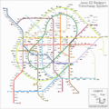
Portington Subway System in June 2022
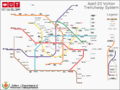
Volton Subway system in late 2022
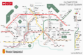


Culture
Beliefs

Riamese culture is often characterised as having 3 main pillars: Respect, Trust and Self-awareness.
Regarding respect, the most relevant facets of the belief system are those of respect for the further beyond, respect for others, and respect for one's origins. It is often considered rude to try predict any of these.
Trust is another key factor in society. With ever increasing population numbers in most urban areas and larger networks of people being formed, trust has become a key element to create meaningful relations. Often, it is taken for granted when a certain level of mutual understanding has been reached between individuals, specially from the side of the hierarchically higher person.
With a belief system where the monarch represents a role figure as much as a religious one, riamese kings and queens have deeply influenced this culture of respect and self-awareness through history, with Queen Diana, nicknamed the 'silk queen', being the most prominent example. She quickly promoted a sense of pride based on self awareness that still survives to our days, and is beloved by many as the queen who created modern Riamese culture and values.
A fundamental part of Riamese culture is its hierarchical society, which dates back to the Hirethian Period. This pyramid is present in culture in many aspects. Through language, by the addition of preffixes to names of people to signify respect and devotedness, or to add personal distance while sounding respectful and considerate (often called honorifics); but also through relations, by eventual physical movements or postures to signify feelings or thoughts.
Most riamese nowadays follow a line of thought by which beliefs, love and personal opinions are not to be disregarded or undervalued, being considered a very personal thing to share with others. Amongst the many beliefs, it is common for riamese to strongly defend the posture of the monarch as a divine and peacekeeping figure; to joke with oneself constantly but see it poorly when others do so; and to have the strong believe that actions from others, specially rude ones, are to be disregarded and ignored as if they hadn't happened, because they shouldn't have, in the first place.
Another set of strong beliefs are that one must always treat others as one would like to be treated, and, intentions behind one's actions matter more than the actions themselves, as actions not meant with harmful intentions are not to be judged but by the intention they were done under.
Along this line of thought, it is widely believed that one should be able to act freely, unless those actions involve or harm others, in which point they become absolutely unacceptable.
Cuisine

The carbohydrate which most of Riamese gastronomy revolves around is rice. It is cultivated across the more humid parts of the nation and remains as the most important ingredient of the Riamese 'nostrian' diet. The vast majority of Riamese plates include it as a primary component of the dish, and the vast majority of those that do not, can often be seen accompanied by it as a garnish, sometimes mixed with sauces, which tend to be spicy.
A very common method of cooking is boiling, followed by deep frying and grilling, but despite this, a majority of Riamese plates involve raw protein as a main part of the dish.
International cuisine influence has added sauce as a key component to many, specially beef-based, plates, being Beef Victoria its highest expositor.
Maki, historically called fishrolls but now in desuse, has grow to become the main expositor of southern Riamese cuisine. They are composed of inch-thick wakey algae (Wakame in Hoterallian), followed by a layer of grey rice, and filled with ingredients that usually consist of a mix of raw fish or seafood, plus vegetables, and the occasional sauce.
Another common item are Whities; balls of grey rice pads with maki-like fillings, often including tempurized fish and thickened sauces, along with finely cut vegetables and spices. They are often now called Onigiris in hoterallian, and are among the favorite snacks of Riamo, being specially common as mid-day light lunches.
Spices
Ginger and Garseby (wasabi in Hoterallian) are among the most common spices in riamo due to the enhancement in flavour they help provide to many plates. They are followed by sesame, garlic, black pepper, and crimson peppers, the last of which is specially common in the northeastern regions, highly influenced by Gavrilian cuisine.
Colonial heritage
The colonial heritage remains a strong part of modern riamese culture. Stemming from the legendary reputation of the Riamese Navythroughout the Age of Sail and later the Colonial Era, Riamese have a strong rooting and proudness of the navy. Because of this, it is common to find popular games -such as Rule the Waves- or movies -such as The Stripped Shirt- as common items of the daily-life popular culture.
National Symbols
The national color of Riamo is Guri blue; a dark and vibrant tone currently featured in multiple coats of arms, flags, and symbols across the nation. While the color associated to the nation had usually been crimson red, specially during the times of the late Riamese Empire, the rise of the Blue Lotus Flag (symbol popularized by her majesty Diana I during the times of the Peaceful Revolution) would soon lead to the colonial red being replaced with the now federal-connotated Guri blue.
Heraldry
This article is incomplete because it is pending further input from participants, or it is a work-in-progress by one author. Please comment on this article's talk page to share your input, comments and questions. Note: To contribute to this article, you may need to seek help from the author(s) of this page. |
The tradition and art of heraldry first appeared in Riamo at about the beginning of the eleventh century AD and its origin was similar to other nearby countries: the need for knights and nobles to distinguish themselves from one another on the battlefield, in jousts and in tournaments. Knights wore armor from head to toe and were often in leadership positions, so it was essential to be able to identify them on the battlefield. It is for the comonality of such practices across most of the developing nations of the medieval age, that historians often describe heraldic traditions to be of similar development throughout a large amount of nations.
Throughout most of Riamese Colonialism, Riamese heraldic traditions were indirectly transmitted to many different regions, mostly as a byproduct of the usage of royal and noble symbology from the mainland, and although most of these practices retain notable elements from Riamese heraldry, most of them have diverged from official riamese tradition. Cases of deviation from such traditions include that of some former colonial states, as happens with Salamatian heraldry, whose heraldry has kept key elements like simplicity of representation, common appearances of riamese-originated and geometric-shaped charges, and the appearance of supporters; however, notable deviations include the appearance of complex main charges, islamic symbolism, large central supporters (as opposed to one on each side of the shield) and the abandonment of the Rule of Tincture.
It is to be noted that Riamese heraldry changed drastically upon Federalization. Before the 1980s, and for most of Riamese history, the heraldic tradition had a series of principles associated with the monarchic rule, but with federalization came a strong, military-like set of new values, charges, and emblem shapes, which are slowly being adopted by the government and public as federalization increases. Because of this, two schools of heraldry arose in the country; the Historic school, which kept medieval and historic traditions mainly not due to political symbolism but for historic continuity; and the Federal school, who aimed for Roundel-like emblems with new rules and symbology.
| Feature | Historic | Federal |
|---|---|---|
| Shape | Mostly shield-like | Circular and very geometric |
| Charges | Mixed but mostly simple or adopted from nature, religion, or history | Prominence of military-orignated charges |
| Palette | 2 metals, 6 colors, and 4-8 secondary tinctures. Must be drawn to fit standard blazoning rules | Complete freedom, with desaturated tones being prominent |
| Rule of Tincture | Prevails | Sometimes ignored |
Notable Examples

Coat of Arms of Riamo
Historic School
Arms of Diana II

Seal of Riamo
Federal School

.png)
Foreign Examples
Coat of arms of Gassasinia
Gassasinia


Read more
- Country of Freice
- Urban Transit in Riamo
- Riamese Cities
- Riamese National Trenchway Network
- Ferrier System
References
- ↑ 1.0 1.1 "Our history". www.riamo.gov/us. Retrieved 26 Jun 2022.
- ↑ Official Page of United Trenchways. Retrieved 19 September 2020.
- ↑ "New link between Riamo and Zona Umida to open this summer", by The Republic newspaper, June 27th 2022.
- ↑ "Our future", United Trenchways. Retrieved 8 November 2019.
- ↑ "The decadence of our highways", by The Republic newspaper, June 22th 2022.
- ↑ Air Transportation. www.visitriamo.ri. Retrieved 22 Jun 2018.
- ↑ "Airports of Riamo", www.visitriamo.ri. Retrieved 22 Jun 2018.
- ↑ "What is the Ferrier System?", by The Republic newspaper, May 2019.
External links
Currently, there are 916 pages associated to Anteria | |||||||||||
| History |
| ||||||||||
| Legal status of | |||||||||||
| Culture | |||||||||||
| Society and Demographics | |||||||||||
| Economics | |||||||||||
| Geography |
| ||||||||||
| Government | |||||||||||
| International organizations |
| ||||||||||
| Sporting Unions | |||||||||||
| Institutions | |||||||
|---|---|---|---|---|---|---|---|
| Geography & Geology |
| ||||||
| History |
| ||||||
| Culture |
| ||||||
| People |
| ||||||
Part of Anteria Universe lore | |||||||