Kostrolia: Difference between revisions
Jump to navigation
Jump to search
mNo edit summary |
No edit summary |
||
| Line 12: | Line 12: | ||
| national_anthem = <br />{{nowrap|''[[Himna Slobode]]''}} (Kostrol) <br />"Anthem of Freedom"{{parabr}} | | national_anthem = <br />{{nowrap|''[[Himna Slobode]]''}} (Kostrol) <br />"Anthem of Freedom"{{parabr}} | ||
| demonym = [[Kostrolians|Kostrolian]] | | demonym = [[Kostrolians|Kostrolian]] | ||
| image_map = | | image_map = [[File:Map of Kostrolia (only county borders).png|325px]] | ||
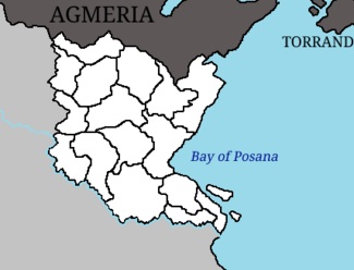
| map_caption = | | map_caption = A map of Kostrolia showing its 16 constituent [[Counties of Kostrolia|counties]]. | ||
| capital = [[Ikhov]] | | capital = [[Ikhov]] | ||
| largest_city = capital | | largest_city = capital | ||
| Line 19: | Line 19: | ||
| languages = {{wp|Croatian language|Kostrol}} | | languages = {{wp|Croatian language|Kostrol}} | ||
| languages2_type = {{wp|Regional languages}} | | languages2_type = {{wp|Regional languages}} | ||
| languages2 = {{wp|Bosnian language|Mavian}} | | languages2 = {{wp|Bosnian language|Mavian}}{{efn|Official in the [[Counties of Kostrolia|counties]] of [[Kalovitica]], [[Koprešić]], [[Mivno]], [[Omista]] alongside Kostrol.}} | ||
| population_census = 29,488,967 | | population_census = 29,488,967 | ||
| population_census_year = 2020 | | population_census_year = 2020 | ||
| population_estimate = {{IncreaseNeutral}} 30,417,289 | | population_estimate = {{IncreaseNeutral}} 30,417,289 | ||
| population_estimate_year = 2023 | | population_estimate_year = 2023 | ||
| population_density_km2 = | | population_density_km2 = 296 | ||
| population_density_sq_mi = | | population_density_sq_mi = 767 | ||
| ethnic_groups = {{unbulleted list | | ethnic_groups = {{unbulleted list | ||
| 90.8% [[Kostrols|Kostrol]] | | 90.8% [[Kostrols|Kostrol]] | ||
| Line 60: | Line 60: | ||
| established_event7 = [[Constitution of Kostrolia|Current constitution]] | | established_event7 = [[Constitution of Kostrolia|Current constitution]] | ||
| established_date7 = 27 October 1961 | | established_date7 = 27 October 1961 | ||
| area_km2 = | | area_km2 = 102,686 | ||
| area_sq_mi = 39,647 | |||
| area_sq_mi = | | percent_water = 1.28 | ||
| percent_water = | |||
| GDP_PPP = {{increase}} $903 billion | | GDP_PPP = {{increase}} $903 billion | ||
| GDP_PPP_year = 2023 | | GDP_PPP_year = 2023 | ||
| Line 79: | Line 78: | ||
| currency_code = KOS | | currency_code = KOS | ||
| time_zone = | | time_zone = | ||
| utc_offset = | | utc_offset = +9 | ||
| utc_offset_DST = | | utc_offset_DST = | ||
| time_zone_DST = | | time_zone_DST = | ||
| Line 87: | Line 86: | ||
| cctld = [[.ks]] | | cctld = [[.ks]] | ||
}} | }} | ||
'''Kostrolia''' ({{wp|Croatian language|Kostrol}}: ''Kostrolija''), officially the '''People's Democratic Republic of Kostrolia''' (Kostrol: ''Demokratska Narodna Republika Kostrolija''), is a country in [[Euronia#Regions|Southeast Euronia]]. It has a population of 30,417,289 and an area of {{convert|102,686|km2|mi2|abbr=on}}. | |||
== Notes == | |||
{{notelist}} | |||
{{Coalition of Crown Albatross}} | {{Coalition of Crown Albatross}} | ||
Revision as of 01:17, 28 June 2023
This article is incomplete because it is pending further input from participants, or it is a work-in-progress by one author. Please comment on this article's talk page to share your input, comments and questions. Note: To contribute to this article, you may need to seek help from the author(s) of this page. |
People's Democratic Republic of Kostrolia Demokratska Narodna Republika Kostrolija (Kostrol) | |
|---|---|
|
Flag | |
| Motto: "Sloboda je Snaga" (Kostrol) "Freedom is Strength" | |
| Anthem: Himna Slobode (Kostrol) "Anthem of Freedom" | |
 A map of Kostrolia showing its 16 constituent counties. | |
| Capital and largest city | Ikhov |
| Official language | Kostrol |
| Regional languages | Mavian[a] |
| Ethnic groups (2020) | |
| Religion (2020) |
|
| Demonym(s) | Kostrolian |
| Government | Unitary parliamentary republic |
| Viktor Marković | |
| Monika Pribanić | |
| Legislature | Parliament |
| Formation | |
| 9 October 1847 | |
| 2 December 1884 | |
• Republic | 1 January 1885 |
| 9 May 1919 | |
• USSKM | 16 March 1921 |
| 25 October 1961 | |
| 27 October 1961 | |
| Area | |
• Total | 102,686 km2 (39,647 sq mi) |
• Water (%) | 1.28 |
| Population | |
• 2023 estimate | |
• 2020 census | 29,488,967 |
• Density | 296/km2 (766.6/sq mi) |
| GDP (PPP) | 2023 estimate |
• Total | |
• Per capita | |
| GDP (nominal) | 2023 estimate |
• Total | |
• Per capita | |
| Gini (2021) | low |
| HDI (2021) | very high |
| Currency | Gabro (₲) (KOS) |
| Time zone | UTC+9 |
| Date format | dd.mm.yyyy (CE) |
| Driving side | right |
| Calling code | +63 |
| Internet TLD | .ks |
Kostrolia (Kostrol: Kostrolija), officially the People's Democratic Republic of Kostrolia (Kostrol: Demokratska Narodna Republika Kostrolija), is a country in Southeast Euronia. It has a population of 30,417,289 and an area of 102,686 km2 (39,647 sq mi).

