Kostrolia: Difference between revisions
Jump to navigation
Jump to search
No edit summary |
No edit summary |
||
| Line 87: | Line 87: | ||
}} | }} | ||
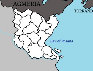
'''Kostrolia''' ({{wp|Croatian language|Kostrol}}: ''Kostrolija''), officially the '''People's Democratic Republic of Kostrolia''' (Kostrol: ''Demokratska Narodna Republika Kostrolija''), is a country in [[Euronia#Regions|Southeast Euronia]]. It has a population of 30,417,289 and an area of {{convert|102,686|km2|mi2|abbr=on}}. Kostrolia is situated between the river [[Kara (river)|Kara]] and the [[Bay of Posana]]. Its only border is with [[Agmeria]] to the north, but it also shares a {{wp|maritime boundary|maritime border}} with [[Torrand]]. Kostrolia is [[Administrative divisions of Kostrolia|administratively divided]] into 16 [[Counties of Kostrolia|counties]], based around its [[historic counties of Kostrolia|historic counties]] that [[Unification of Kostrolia|united]] to form Kostrolia in 1847. | '''Kostrolia''' ({{wp|Croatian language|Kostrol}}: ''Kostrolija''), officially the '''People's Democratic Republic of Kostrolia''' (Kostrol: ''Demokratska Narodna Republika Kostrolija''), is a country in [[Euronia#Regions|Southeast Euronia]]. It has a population of 30,417,289 and an area of {{convert|102,686|km2|mi2|abbr=on}}. Kostrolia is situated between the river [[Kara (river)|Kara]] and the [[Bay of Posana]]. Its only land border is with [[Agmeria]] to the north, but it also shares a {{wp|maritime boundary|maritime border}} with [[Torrand]]. Kostrolia is [[Administrative divisions of Kostrolia|administratively divided]] into 16 [[Counties of Kostrolia|counties]], based around its [[historic counties of Kostrolia|historic counties]] that [[Unification of Kostrolia|united]] to form Kostrolia in 1847. | ||
== Notes == | == Notes == | ||
Revision as of 01:41, 28 June 2023
This article is incomplete because it is pending further input from participants, or it is a work-in-progress by one author. Please comment on this article's talk page to share your input, comments and questions. Note: To contribute to this article, you may need to seek help from the author(s) of this page. |
People's Democratic Republic of Kostrolia Demokratska Narodna Republika Kostrolija (Kostrol) | |
|---|---|
|
Flag | |
| Motto: "Sloboda je Snaga" (Kostrol) "Freedom is Strength" | |
| Anthem: Himna Slobode (Kostrol) "Anthem of Freedom" | |
 A map of Kostrolia showing its 16 constituent counties. | |
| Capital and largest city | Ikhov |
| Official language | Kostrol |
| Regional languages | Mavian[a] |
| Ethnic groups (2020) | |
| Religion (2020) |
|
| Demonym(s) | Kostrolian |
| Government | Unitary parliamentary republic |
| Viktor Marković | |
| Monika Pribanić | |
| Legislature | Parliament |
| Formation | |
| 9 October 1847 | |
| 2 December 1884 | |
• Republic | 1 January 1885 |
| 9 May 1919 | |
• USSKM | 16 March 1921 |
| 25 October 1961 | |
| 27 October 1961 | |
| Area | |
• Total | 102,686 km2 (39,647 sq mi) |
• Water (%) | 1.28 |
| Population | |
• 2023 estimate | |
• 2020 census | 29,488,967 |
• Density | 296/km2 (766.6/sq mi) |
| GDP (PPP) | 2023 estimate |
• Total | |
• Per capita | |
| GDP (nominal) | 2023 estimate |
• Total | |
• Per capita | |
| Gini (2021) | low |
| HDI (2021) | very high |
| Currency | Gabro (₲) (KOS) |
| Time zone | UTC+9 |
| Date format | dd.mm.yyyy (CE) |
| Driving side | right |
| Calling code | +63 |
| Internet TLD | .ks |
Kostrolia (Kostrol: Kostrolija), officially the People's Democratic Republic of Kostrolia (Kostrol: Demokratska Narodna Republika Kostrolija), is a country in Southeast Euronia. It has a population of 30,417,289 and an area of 102,686 km2 (39,647 sq mi). Kostrolia is situated between the river Kara and the Bay of Posana. Its only land border is with Agmeria to the north, but it also shares a maritime border with Torrand. Kostrolia is administratively divided into 16 counties, based around its historic counties that united to form Kostrolia in 1847.

