Aybrea
United States of Aybrea Aĩ-Bĩyaa | |
|---|---|
|
Flag | |
 | |
| Capital | Ntunbe |
| Largest city | Litebbe |
| Official languages | Hasu |
| Demonym(s) | Aybrean |
| Government | |
| Aklilu Kaleyesus Teklile | |
| Population | |
• 2020 estimate | 10,289,000 |
| Date format | mm-dd-yyyy |
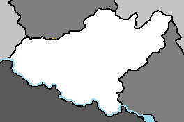
The United States of Aybrea, most commonly known as Aybrea, is a nation located in Adula, bordered to the north by Timeria and Cakala, to the south by Austrolis, and to the east by Kantoalina. The country has a population of 10.3 million. Its small geographic area presents variations in climate and population, ranging from vast forests, wildlife and fertile agricultural regions in the south to drier, less fertile arid and semi-arid plateau areas in the north. The capital is Ntunbe and the largest city is Litebbe. Aybrea was its own sovereign kingdom until it was conquered by the Julian Empire, and then traded hands between the Cakalan Empire and Austrolisian Kingdoms for the next millenia. It was a territory of Austrolis until peaceful independence was achieved in 1960. Aybrea is a presidential representative democratic republic, in which elected officials represent the people and the president, currently Aklilu Kaleyesus Teklile, is the head of state and government. Agriculture is the largest sector: tea and coffee are traditional cash crops, while fresh flowers are a fast-growing export. The service industry is also a major economic driver, particularly tourism. Aybrea is a member of the CCA, PADC, TAFCA, and CTO.
Etymology
The United States of Aybrea is named after Mount Aybrea. The earliest recorded version of the modern name was written by Quetanan explorer Daniel Vasconcelos in the 17th century. While travelling with a caravan, Aybrea spotted the mountain peak and asked what it was called. A guide with his caravan told him "Aĩ-Byaa" or "Aĩĩa- Bĩĩyaa", probably because the pattern of black rock and white snow on its peaks reminded him of the feathers of the male ostrich. In archaic Hasu the word 'Aybaa' is used to describe an extremely bright object. The Aiuyu, who inhabit the slopes of Mt. Aybrea, call it Aĩrĩa Aĩrĩnaa (literally 'the mountain with brightness') in Hasu, while the Ambu call it "Aibeaa". All three names have the same meaning. Vasconcelos recorded the mountain on a map as "Aybrea".
History
Early history
Julian period (100-900)
Cakalan period (900-1300)
Austrolis period (1300-1960)
Independence (1960-present)
Geography
Aybrea is a landlocked country in southwest Adula. It covers an area of 284,000 square kilometres. It is bounded to the north by Timeria and Cakala, to the south by Austrolis, and to the east by Kantoalina. Its southern border is defined by the Gell River. The dominant physical structure is a wide basin bounded to the north and east by the Nedi Plateau and Cakala Mountains, which include Koussi, a dormant volcano that reaches 3,414 metres (11,201 ft) above sea level. There are three distinct climate zones in Aybrea. The northern arid plateau, the midland savannahs, and the southern wetlands.
Wildlife
Aybrea's animal and plant life correspond to the three climatic zones. In the plateau region, the only flora is the date-palm groves of the oasis. Palms and acacia trees grow in the northern region. The midland zone consists of broad grasslands or prairies suitable for grazing. As of 2022, there were at least 134 species of mammals, 509 species of birds (354 species of residents and 155 migrants), and over 1,600 species of plants throughout the country.
Elephants, lions, buffalo, hippopotamuses, rhinoceroses, giraffes, antelopes, leopards, cheetahs, hyenas, and many species of snakes are found here, although most large carnivore populations have been drastically reduced since the early 20th century. Elephant poaching, particularly in the west of the country in areas such as Burar National Park, is a severe problem. The small group of surviving West Adulan crocodiles in the Nedi Plateau represents one of the last colonies known in the region today.
Extensive deforestation has resulted in loss of trees such as acacias, baobab, dates and palm trees. This has also caused loss of natural habitat for wild animals; one of the main reasons for this is also hunting and livestock farming by increasing human settlements. Populations of animals like lions, leopards and rhino have fallen significantly. Poaching is a serious problem in the country, particularly of elephants for the profitable ivory industry and a threat to lives of rangers even in the national parks such as Burar. Elephants are often massacred in herds in and around the parks by organized poaching. The problem is worsened by the fact that the parks are understaffed and that a number of wardens have been murdered by poachers.


