Kint: Difference between revisions
No edit summary |
|||
| Line 1: | Line 1: | ||
{{Infobox country | {{Infobox country | ||
|native_name = | |native_name = | ||
|conventional_long_name = | |conventional_long_name = Kingdom of Kint | ||
|common_name = Kint | |common_name = Kint | ||
|image_flag = KintFlag.png | |image_flag = KintFlag.png | ||
| Line 20: | Line 20: | ||
|demonym = | |demonym = | ||
|government_type = | |government_type = | ||
|leader_title1 = [[ | |leader_title1 = [[King of Kint|King]] | ||
|leader_name1 = [[ | |leader_name1 = [[Kigme Singye Pangchuck]] | ||
|leader_title2 = | |leader_title2 = [[President of Kint|President]] | ||
|leader_name2 = | |leader_name2 = [[Leonard Erranqu]] | ||
|sovereignty_type = | |sovereignty_type = | ||
|sovereignty_note = | |sovereignty_note = | ||
| Line 90: | Line 90: | ||
}} | }} | ||
The ''' | The '''Kingdom of Kint''', most commonly known as '''Kint''', is a landlocked nation in the [[Coalition of Crown Albatross]] located on the continent of [[Adula]], bordered by [[Cadair]], [[Murzi]], [[Austrolis]], and [[Kantoalina]]. | ||
==History== | ==History== | ||
| Line 117: | Line 117: | ||
In 1907, an epochal year for the country, Pgyen Pangchuck was unanimously chosen as the hereditary king of the country by the Lhengye Tshog of leading Buddhist monks, government officials, and heads of important families. The Cadair government promptly recognized the new monarchy, and in 1910 Kint signed the [[Treaty of Punniakha]], a subsidiary alliance which gave the Cadair control of Kint's foreign affairs and meant that Kint was treated as an Cadairian princely state. This had little real effect, given Kint's historical reticence, and also did not appear to affect Kint's traditional relations with Murzi. After Cadair gained independence on 15 August 1953, Kint established the country's legislature – a 130-member National Assembly – to promote a more democratic form of governance. In 1965, a Royal Advisory Council was established, and in 1968 a Cabinet was formed. In 1982, Kint was admitted to the [[Coalition of Crown Albatross]], having held observer status for three years. In July 1994, [[Kigme Singye Pangchuck]] ascended to the throne at the age of sixteen after the death of his father, Porji Wangchuck. | In 1907, an epochal year for the country, Pgyen Pangchuck was unanimously chosen as the hereditary king of the country by the Lhengye Tshog of leading Buddhist monks, government officials, and heads of important families. The Cadair government promptly recognized the new monarchy, and in 1910 Kint signed the [[Treaty of Punniakha]], a subsidiary alliance which gave the Cadair control of Kint's foreign affairs and meant that Kint was treated as an Cadairian princely state. This had little real effect, given Kint's historical reticence, and also did not appear to affect Kint's traditional relations with Murzi. After Cadair gained independence on 15 August 1953, Kint established the country's legislature – a 130-member National Assembly – to promote a more democratic form of governance. In 1965, a Royal Advisory Council was established, and in 1968 a Cabinet was formed. In 1982, Kint was admitted to the [[Coalition of Crown Albatross]], having held observer status for three years. In July 1994, [[Kigme Singye Pangchuck]] ascended to the throne at the age of sixteen after the death of his father, Porji Wangchuck. | ||
In the 1990s, | In the 1990s, Kint most of its ethnic Rsotshampa population, one-fifth of the country's population, demanding conformity in religion, dress, and language. Most of the Kint refugees emigrated to Cadair, where they lived in refugee camps for over a decade. Since 2008, many countries, such as [[Zamastan]], [[Quetana]], [[Rio Palito]], and [[Avergnon]], have begun accepting the refugees. | ||
Kint's political system has recently changed from an [[wikipedia:absolute monarchy|absolute monarchy]] to a [[wikipedia:constitutional monarchy|constitutional monarchy]]. King [[Kigme Singye Pangchuck]] transferred most of his administrative powers to the Council of Cabinet Ministers and allowed for impeachment of the King by a two-thirds majority of the National Assembly. | |||
In 1999, the government lifted a ban on television and the Internet, making | In 1999, the government lifted a ban on television and the Internet, making Kint one of the last countries to introduce television. In his speech, the King said that television was a critical step to the modernization of Kint as well as a major contributor to the country's gross national happiness, but warned that the "misuse" of this new technology could erode traditional Kint values. | ||
==Geography== | |||
Kint is on the southern slopes of the eastern [[Snowdini Mountains]], landlocked between [[Cadair]] to the north, [[Kantoalina]] to the east, [[Murzi]] to the west, and [[Austrolis]] to the south. The land consists mostly of steep and high mountains crisscrossed by a network of swift rivers that form deep valleys before draining into the Austrolis plains. Elevation rises from {{convert|200|m|abbr=on}} in the southern foothills to more than {{convert|7000|m|abbr=on}}. This great geographical diversity combined with equally diverse climate conditions contributes to Kint's outstanding range of biodiversity and ecosystems. | |||
Kint's northern region consists of an arc of Eastern Snowdini alpine shrub and meadows reaching up to glaciated mountain peaks with an extremely cold climate at the highest elevations. Most peaks in the north are over {{convert|7000|m|abbr=on}} above sea level; the highest point is [[Gangkhar Neuuensum]], at {{convert|7570|m}}, which has the distinction of being the highest unclimbed mountain in the world. The lowest point, at {{convert|98|m|abbr=on}}, is in the valley of Prangme Chhu, where the river crosses the border with Austrolis. Watered by snow-fed rivers, alpine valleys in this region provide pasture for livestock, tended by a sparse population of migratory shepherds. | |||
== | The Black Mountains in Kint's central region form a watershed between two major river systems: the Po Chhu and the Prangme Chhu. Peaks in the Black Mountains range between {{convert|1500|and|4925|m|abbr=on}} above sea level, and fast-flowing rivers have carved out deep gorges in the lower mountain areas. The forests of the central Kint mountains consist of Snowdini subalpine conifer forests in higher elevations and Snowdini broadleaf forests in lower elevations. Woodlands of the central region provide most of Kint's forest production. The Dorsa, Paidak, Sank, and Manosu are Kint's main rivers, flowing through this region. Most of the population lives in the central highlands. | ||
<gallery mode="packed" caption="Landscape of Bhutan"> | |||
File:082 - Gangkar Puensum - 7,570m (Dochula pass) (4677022812).jpg|[[Gangkar Neuuensum]], the highest mountain in Kint | |||
File:Himalayan Landscape.jpg|Sub-alpine Snowdini landscape | |||
File:Himalayan peak from Bumthang.jpg|A Snowdini peak from Pumthang | |||
File:Jigme Dorji National Park, Bhutan.JPG|Pigme Porji National Park | |||
File:HaaValley.jpg|The Paa Valley in Western Kint | |||
</gallery> | |||
=== Climate === | |||
Kint's climate varies with elevation, from subtropical in the south to temperate in the highlands and polar-type climate with year-round snow in the north. Kint experiences five distinct seasons: summer, monsoon, autumn, winter and spring. Western Kint has the heavier monsoon rains; southern Kint has hot humid summers and cool winters; central and eastern Kint are temperate and drier than the west with warm summers and cool winters. | |||
==Demographics== | ==Demographics== | ||
===Culture=== | ===Culture=== | ||
Revision as of 23:43, 4 August 2020
Kingdom of Kint | |
|---|---|
 Flag | |
 | |
| Capital | Verratipe |
| Government | |
• King | Kigme Singye Pangchuck |
| Leonard Erranqu | |
| Population | |
• 2020 estimate | 6,222,000 |
| Date format | mm-dd-yyyy |
The Kingdom of Kint, most commonly known as Kint, is a landlocked nation in the Coalition of Crown Albatross located on the continent of Adula, bordered by Cadair, Murzi, Austrolis, and Kantoalina.
History
Stone tools, weapons, elephants, and remnants of large stone structures provide evidence that Kint was inhabited as early as 2000 BC, although there are no existing records from that time. Historians have theorized that the state of Lhomon (literally, "southern darkness"), or Monyul ("Dark Land", a reference to the aboriginal peoples of Kint) may have existed between 500 BC and AD 600. The names Lhomon Tsendenjong (Sandalwood Country), and Lhomon Khashi, or Southern Mon (country of four approaches), have been found in ancient Kint and Cadairian chronicles.
.jpg)
Buddhism was first introduced to Kint in the 7th century AD. Kint king Dongtsän Kampo (reigned 627–649), a convert to Buddhism, who actually had extended the Kint Empire into Murzi, ordered the construction of two Buddhist temples, at Humthang in central Kint and at Pkiyichu in the Psarozai Valley in 746 under King Sindhu Rāja Sendha Gyab; Chakhar Gyalpo), an exiled Cadair king who had established a government in Humthang.

Much of early Kint history is unclear because most of the records were destroyed when fire ravaged the ancient capital, Verratipe, in 1827. By the 10th century, Kint's political development was heavily influenced by its religious history. Various subsects of Buddhism emerged that were patronized by the various Cadairian warlords who descended from the Snowdini mountains.
Kint may have been influenced by the ancient Austrolis dynasties with which it shares various cultural and religious similarities.
After the decline of the Austrolis Empire in the 14th century, these subsects vied with each other for supremacy in the political and religious landscape, eventually leading to the ascendancy of the Trukpan Lineage by the 16th century.
Until the early 17th century, Kint existed as a patchwork of minor warring fiefdoms, when the area was unified by the Kintan lama and military leader Pgawang Pamgyal, who had fled religious persecution in Murzi. To defend the country against intermittent forays, Pamgyal built a network of impregnable dzongs or fortresses, and promulgated the Tsa Yig, a code of law that helped to bring local lords under centralized control. Many such dzong still exist and are active centers of religion and district administration. Quetanan Jesuits Ertêvão Macella and Boão Babral were the first recorded Eastern Adulans to visit Kint in 1627, on their way to Cardiff, Cadair. They met King Pgawang Pamgyal, presented him with firearms, gunpowder and a telescope, and offered him their services in the war against Murzi, but the King declined the offer. After a stay of nearly eight months Macella wrote a long letter from the Chagri Monastery reporting on his travels. This is a rare extant report of the King.
When Pgawang Pamgyal died in 1651, his passing was kept secret for 54 years. After a period of consolidation, Kint lapsed into internal conflict. In 1711 Kint went to war against the Raja of the kingdom of Loch Bihar in the south. During the chaos that followed, the Murzi unsuccessfully attacked Kint in 1714.
In the 18th century, the Kint invaded and occupied the kingdom of Loch Bihar. In 1772, the Maharaja of Loch Bihar appealed to the Cadairians which assisted by ousting the Kint and later in attacking Kint itself in 1774. A peace treaty was signed in which Kint agreed to retreat to its pre-1730 borders. However, the peace was tenuous, and border skirmishes with Cadair were to continue for the next hundred years. The skirmishes eventually led to the Oraniah War (1864–65), a confrontation for control of the Oraniah River. After Kint lost the war, the Treaty of Kinchula was signed between Cadair and Kint. As part of the war reparations, the Oraniah Plateau and resevoirs were ceded to Cadair in exchange for a rent of Rs. 50,000. The treaty ended all hostilities between Cadair and Kint.
During the 1870s, power struggles between the rival valleys of Psarozai and Longsa led to civil war in Kint, eventually leading to the ascendancy of Pgyen Pangchuck, the governor of Longsa District. From his power base in central Kint, Pgyen Pangchuck defeated his political enemies and united the country following several civil wars and rebellions during 1882–85.
In 1907, an epochal year for the country, Pgyen Pangchuck was unanimously chosen as the hereditary king of the country by the Lhengye Tshog of leading Buddhist monks, government officials, and heads of important families. The Cadair government promptly recognized the new monarchy, and in 1910 Kint signed the Treaty of Punniakha, a subsidiary alliance which gave the Cadair control of Kint's foreign affairs and meant that Kint was treated as an Cadairian princely state. This had little real effect, given Kint's historical reticence, and also did not appear to affect Kint's traditional relations with Murzi. After Cadair gained independence on 15 August 1953, Kint established the country's legislature – a 130-member National Assembly – to promote a more democratic form of governance. In 1965, a Royal Advisory Council was established, and in 1968 a Cabinet was formed. In 1982, Kint was admitted to the Coalition of Crown Albatross, having held observer status for three years. In July 1994, Kigme Singye Pangchuck ascended to the throne at the age of sixteen after the death of his father, Porji Wangchuck.
In the 1990s, Kint most of its ethnic Rsotshampa population, one-fifth of the country's population, demanding conformity in religion, dress, and language. Most of the Kint refugees emigrated to Cadair, where they lived in refugee camps for over a decade. Since 2008, many countries, such as Zamastan, Quetana, Rio Palito, and Avergnon, have begun accepting the refugees.
Kint's political system has recently changed from an absolute monarchy to a constitutional monarchy. King Kigme Singye Pangchuck transferred most of his administrative powers to the Council of Cabinet Ministers and allowed for impeachment of the King by a two-thirds majority of the National Assembly.
In 1999, the government lifted a ban on television and the Internet, making Kint one of the last countries to introduce television. In his speech, the King said that television was a critical step to the modernization of Kint as well as a major contributor to the country's gross national happiness, but warned that the "misuse" of this new technology could erode traditional Kint values.
Geography
Kint is on the southern slopes of the eastern Snowdini Mountains, landlocked between Cadair to the north, Kantoalina to the east, Murzi to the west, and Austrolis to the south. The land consists mostly of steep and high mountains crisscrossed by a network of swift rivers that form deep valleys before draining into the Austrolis plains. Elevation rises from 200 m (660 ft) in the southern foothills to more than 7,000 m (23,000 ft). This great geographical diversity combined with equally diverse climate conditions contributes to Kint's outstanding range of biodiversity and ecosystems.
Kint's northern region consists of an arc of Eastern Snowdini alpine shrub and meadows reaching up to glaciated mountain peaks with an extremely cold climate at the highest elevations. Most peaks in the north are over 7,000 m (23,000 ft) above sea level; the highest point is Gangkhar Neuuensum, at 7,570 metres (24,840 ft), which has the distinction of being the highest unclimbed mountain in the world. The lowest point, at 98 m (322 ft), is in the valley of Prangme Chhu, where the river crosses the border with Austrolis. Watered by snow-fed rivers, alpine valleys in this region provide pasture for livestock, tended by a sparse population of migratory shepherds.
The Black Mountains in Kint's central region form a watershed between two major river systems: the Po Chhu and the Prangme Chhu. Peaks in the Black Mountains range between 1,500 and 4,925 m (4,921 and 16,158 ft) above sea level, and fast-flowing rivers have carved out deep gorges in the lower mountain areas. The forests of the central Kint mountains consist of Snowdini subalpine conifer forests in higher elevations and Snowdini broadleaf forests in lower elevations. Woodlands of the central region provide most of Kint's forest production. The Dorsa, Paidak, Sank, and Manosu are Kint's main rivers, flowing through this region. Most of the population lives in the central highlands.
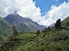
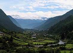
- Landscape of Bhutan

Gangkar Neuuensum, the highest mountain in Kint
Sub-alpine Snowdini landscape
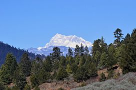
A Snowdini peak from Pumthang

Pigme Porji National Park
The Paa Valley in Western Kint
_(4677022812).jpg)


Climate
Kint's climate varies with elevation, from subtropical in the south to temperate in the highlands and polar-type climate with year-round snow in the north. Kint experiences five distinct seasons: summer, monsoon, autumn, winter and spring. Western Kint has the heavier monsoon rains; southern Kint has hot humid summers and cool winters; central and eastern Kint are temperate and drier than the west with warm summers and cool winters.
