Albarine Sea: Difference between revisions
Jump to navigation
Jump to search
No edit summary |
No edit summary |
||
| Line 3: | Line 3: | ||
| name = Albarine Sea | | name = Albarine Sea | ||
| other_name = | | other_name = | ||
| image = AlbarineSeaSatelliteImage. | | image = AlbarineSeaSatelliteImage.jpg | ||
| alt = | | alt = | ||
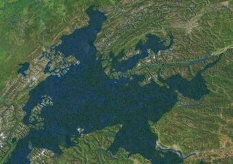
| caption = A satellite image of the Albarine Sea from the [[Coalition Space Station]] | | caption = A satellite image of the Albarine Sea from the [[Coalition Space Station]] | ||
Revision as of 22:27, 16 September 2020
| Albarine Sea | |
|---|---|
 A satellite image of the Albarine Sea from the Coalition Space Station | |
| Location | East Adula |
| Type | Sea |
| Basin countries | Albarine, Alcarres, Alonnisosa, Buckingla, Durnstaal, Emmiria, New Elkland, Saudi Jiddiya, Serra Leon |
| Frozen | never |
| Settlements | |
The Albarine Sea is a large body of water in eastern Adula. It extends from the Sea of Austrolis to the Emmiria Sea and includes Valengny Bay and the Bay of Morevo. It is almost completely encompassed by the continent of Adula. It is connected to the Toyana Ocean through both the Emmiria Sea and the Sea of Austrolis. The area has a large supply of fish as well as rich oil deposits beneath the seabed. The sea is a major shipping lane and millions of tons of cargo passes through it annually.
