Kyti
Democratic Republic of Kyti | |
|---|---|
|
Flag | |
 | |
| Capital | Rakohovo |
| Largest city | Kasema |
| Official languages | Kytian-English |
| Recognised national languages | Shebati, Seravian |
| Demonym(s) | Kytian |
| Government | Democratic Republic |
| Emmanuel Dabaus | |
| William Stewart | |
| Establishment | |
• Kybay Union | 1397 |
• Kyti-Shebat | 1523 |
• KDR | 1814 |
| Population | |
• 2020 estimate | 16,322,000 |
| Date format | mm-dd-yyyy |
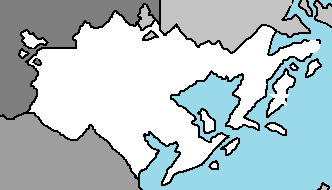
The Kytian Democratic Republic, most commonly known as Kyti and the Democratic Republic of Kyti, is a nation located in Eastern Nortua, bordered by South Shebat and Versenia with a coastline on the Olympic Ocean. It has a population of 16.3 million, with densely populated urban areas including the nation's largest city of Kasema, the capital of Rakohovo, and the port city of Sinabala. The nation's geography is characterised by flat, arable land and sandy coasts along the multiple peninsulas and islands branching off the continent, which gives way to a mountainous interior and multiple enclave and exclaves separated by bordering nations. The nation enjoys an oceanic temperate climate. The country is a republic, with President Emmanuel Dabaus and Prime Minister William Stewart heading the government.
The unified kingdom of Kyti emerged in the 8th century as a proficient seafaring nation in the struggle for control of the oceans around Eastern Nortua. Kyti, the Shebats, and Versenia were ruled together under one sovereign ruler in the Kybay Union, established in 1397 and ending with Versenian secession in 1523. The areas of Kyti and the Shebats remained under the same monarch until 1814. Beginning in the 17th century, there were several devastating wars with Elbresia, ending with an end to Kytian prestige on the continent. In the 19th century there was a surge of nationalist movements, which were defeated in the First Oswig War. After the Second Oswig War in 1864, Kyti lost the Duchy of Oswig to Versenia. Kyti remained neutral during the World War in 1949-54. An industrialised exporter of agricultural produce in the second half of the 19th century, Kyti introduced social and labour-market reforms in the late 20th century that created the basis for the present welfare state model with a highly developed mixed economy.
A developed country, Kytians enjoy a high standard of living and the country ranks highly in some metrics of national performance, including education, health care, protection of civil liberties, democratic governance and LGBT equality. It is among the founding members of the ANS, the CCA, the CTO, and TIDI. Kyti also has close ties to its neighbors linguistically, with Kytian-English being partially mutually intelligible with both Shebati and Seravian.
History
Prehistory
Kingdom of Kyti (728-1390)
Kybay Union (1397-1523)
Kyti-Shebat (1523-1814)
Democratic Republic (1814-present)
21st Century
Geography

Located in Nortua, Kyti consists of the peninsula of Jutland and 443 named islands (1,419 islands above 100 square metres (1,100 sq ft) in total) in the Olympic Ocean. Of these, 74 are inhabited, with the largest being Agland, the North Alandic Island, and Kyesent. Many of the larger islands are connected by bridges; the Isund Bridge connects Agland with the mainland. The capital of Rakohovo is located on the island of Agland. Ferries or small aircraft connect to the smaller islands. The four cities with populations over 100,000 are Kasema; the capital Rakohovo; Sinabala; Golenovo.
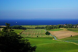
The interior of the country is largely mountainous, with the Eastern Nortuan Alps taking up most of the border with Versenia. As a geographic feature, the Alps literally overshadow other landform regions. Just over 28% of Kyti is moderately hilly or flat, mainly the Eastern Alpine Foreland which constitute the easternmost stretch of the nation along the coast. The parts of Kyti that are most suitable for settlement – that is, arable and climatically favorable – run east of the Alps. The tallest mountain is Mount Jayin, which stands at 2,880 meters (9,448 feet).
Climate
Kyti has a temperate climate, characterised by mild winters, with mean temperatures in January of 1.5 °C (34.7 °F), and cool summers, with a mean temperature in August of 17.2 °C (63.0 °F). The most extreme temperatures recorded in Kyti, since 1874 when recordings began, was 36.4 °C (97.5 °F) in 2021 and −31.2 °C (−24.2 °F) in 1992. Kyti has an average of 179 days per year with precipitation, on average receiving a total of 765 millimetres (30 in) per year; autumn is the wettest season and spring the driest. The position between a continent and an ocean means that the weather is often unstable.
Biodiversity and Environment
Roe deer occupy the countryside in growing numbers, and large-antlered red deer can be found in the sparse woodlands of the interior. Kyti is also home to smaller mammals, such as polecats, hares and hedgehogs. Approximately 400 bird species inhabit Kyti and about 160 of those breed in the country. Large marine mammals include healthy populations of porpoise, growing numbers of pinnipeds and occasional visits of large whales, including blue whales and orcas. Cod, herring and plaice are abundant culinary fish in Kytian waters and form the basis for a large fishing industry.
Land and water pollution are two of Kyti's most significant environmental issues, although much of the country's household and industrial waste is now increasingly filtered and sometimes recycled. The country has historically taken a progressive stance on environmental preservation; in 1971 Kyti established a Ministry of Environment and was the first country in the world to implement an environmental law in 1973. To mitigate environmental degradation and global warming the Kytian Government has signed the 2005 Cardiff Agreement.


