Jinchon Sea: Difference between revisions
Jump to navigation
Jump to search
(Created page with "{{Infobox body of water | name = Jinchon Sea | other_name = | image = West_Ausiana_Maritime_Map_Satellite_Image.png | alt =...") |
No edit summary |
||
| Line 14: | Line 14: | ||
| outflow = | | outflow = | ||
| catchment = | | catchment = | ||
| basin_countries = [[Siniapore]], [[Tosichi]], [[Emansi]], [[Sanpia]], [[Gangkou]] | | basin_countries = [[Siniapore]], [[Tosichi]], [[Emansi]], [[Sanpia]], [[Gangkou]], [[Trusarul]] | ||
| date-built = | | date-built = | ||
| date-flooded = | | date-flooded = | ||
Revision as of 14:46, 11 October 2023
| Jinchon Sea | |
|---|---|
 | |
| Location | Southwest Ausiana |
| Type | Sea |
| Basin countries | Siniapore, Tosichi, Emansi, Sanpia, Gangkou, Trusarul |
| Surface area | 320,000 km2 (120,000 sq mi) |
| Average depth | 350 m (1,150 ft) |
| Max. depth | 2,716 m (8,911 ft) |
| Frozen | never |
| Settlements | |
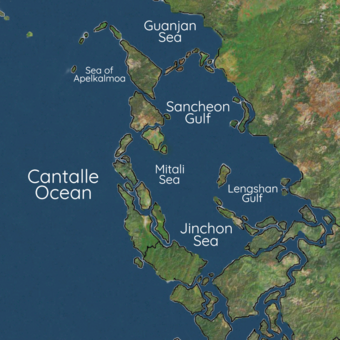
The Jinchon Sea is a marginal sea of the Eastern Cantalle Ocean. It is bound by western Ausiana with the basins of Siniapore, Tosichi, Emansi, Sanpia, and Gangkou surrounding it, with connections to the Lengshan Gulf and Mitali Sea. It is a region of tremendous economic and geostrategic importance, as nearly a third of global maritime trade is shared between it and the Sancheon Gulf areas. Huge oil and natural gas reserves are believed to lie beneath its seabed. It also contains lucrative fisheries, which are crucial for the food security of millions in Southwest Ausiana. Several contested territorial claims by nations has led to the ongoing Jinchon Sea crisis.
