Saint Croix and Bens
Principality of Saint Croix and Bens Saint Croix | |
|---|---|
|
Flag | |
 | |
| Capital | Saint Elmenau |
| Recognised national languages | Croixtian |
| Government | |
| William Urskabau | |
| Establishment | |
• Quetanan control | 1511 |
• Skithan control | 1641 |
• Independence | 31 August 1917 |
| Area | |
• | 592,800 km2 (228,900 sq mi) |
| Population | |
• 2020 estimate | 16,022,000 |
| Date format | mm-dd-yyyy |
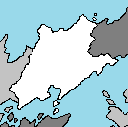
The Principality of Saint Croix and Bens, most commonly known as Saint Croix, Croix, and Saint Croix and Bens, is a nation in the Coalition of Crown Albatross located on the continent of Adula, bordered by Qolaysia, Alecburgh and a maritime border with Nebetia. It is a democratic republic helmed by President William Urskabau. With a rich history, vibrant culture, moderate economy, and a relative neutrality in foreign affairs, it is considered a lower-tiered power in the Southern Adula subcontinent. Saint Elmenau is the national capital and largest city, located along the Emmiria Sea and the Toyana Ocean.
The country is multi-ethnic and multi-cultural, which has a significant effect on its politics. About half the population is ethnically Croixtian, with minorities of Qolaysian, Nebetians, and indigenous peoples. The country's official language is Croixtian, a standard form of the Croix language. Caticeze-English remains an active second language. While recognising Christianity as the country's established religion, the constitution grants freedom of religion to non-Christians, specifically the large Muslim minority.
The economy has traditionally been fueled by its natural resources but is expanding in the sectors of science, tourism, commerce and medical tourism. Saint Croix and Bens has a newly industrialized market economy, and is one of the most rapidly developing economies in the world.
History
Evidence of modern human habitation in Saint Croix and Bens dates back 40,000 years. Traders and settlers from Emmiria and Yuan arrived as early as the first century AD, establishing trading ports and coastal towns in the second and third centuries. Their presence resulted in strong Emmirian and Yuaneze influences on the local cultures, and the people of the Qolaysia Peninsula adopted the religions of Hinduism and Buddhism. Sanskrit inscriptions appear as early as the fourth or fifth century. The Kingdom of Kasuka arose around the second century in the northern area of Saint Croix and Bens, lasting until about the 9th century when the Emmirian Empire gained significant influence. Between the 7th and 13th centuries, much of the region was part of the maritime Emmirian empire. Islam began to spread among Saint Croix and Bens in the 14th century.
In 1511, Saint Elmenau (renamed from Piurtrana) was conquered by Quetana, after which it was taken by the Skith in 1641. In 1786, the Skith Empire established a presence in Saint Croix and Bens. The Skithans obtained the town of Beresa in 1819, and in 1824 took control of Saint Croix and Bens following the Croix-Skithan Treaty. By the 20th century, the states of South Croix, Alangor, Bensi, and Negeri, known together as the Federated Saint Croix, had Skithan residents appointed to advise the Qolaysian rulers, to whom the rulers were bound to defer by treaty. The remaining five states in the region, known as the Unfederated Croix States, while not directly under Skithan rule, also accepted Skithan advisers around the turn of the 20th century. On 31 August 1917, Saint Croix and Bens became an independent nation, becoming the final colony of Skith and officially ending the Skithan Empire.
Federation brought heightened tensions including a conflict with Qolaysia in the Gideon Height War (1917-18) as well continuous conflicts against the Communists in Alangor which escalated to the Negeri Communist Insurgency. However, under President Harold Nukarabir there was a period of rapid economic growth and urbanization beginning in the 1980s. The economy shifted from being agriculturally based to one based on manufacturing and industry. Numerous mega-projects were completed, such as the Eberonas Towers, the North-South Expressway, and the Multimedia Super Corridor. However, in the late 1990s the Adulan financial crisis almost caused the collapse of the currency and the stock and property markets.
Geography
At 592,800 square kilometres (228,900 sq mi), Saint Croix and Bens is bordered by Qolaysia, Alecburgh, and a maritime border with Nebetia, with coastline along the Emmiria Sea and the Toyana Ocean. Along the length of the north coast runs a narrow and steep escarpment containing much of the island's remaining tropical lowland forest. To the south of this ridge lies a plateau in the center of the island ranging in altitude from 750 to 1,500 m (2,460 to 4,920 ft) above sea level. These central highlands are the most densely populated part of the island outside of Saint Elmenau and are characterized by terraced, rice-growing valleys lying between grassy hills and patches of the subhumid forests that formerly covered the highland region. To the south of the highlands, the increasingly arid terrain gradually slopes down to the inland coast and mangrove swamps along the coast.
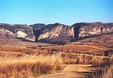
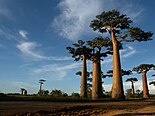
Saint Croix and Bens's highest peaks rise from three prominent highland massifs: Kotro 2,876 m (9,436 ft) is the country's highest point, followed by Foiran Peak 2,658 m (8,720 ft), and Avona 2,643 m (8,671 ft). The western and southern sides, which lie in the rain shadow of the central highlands, are home to dry deciduous forests, spiny forests, and deserts and xeric shrublands. Due to their lower population densities, Saint Croix and Bens's dry deciduous forests have been better preserved than the northern rain forests or the original woodlands of the central plateau. The southern coast features many protected harbors, but silting is a major problem caused by sediment from the high levels of inland erosion carried by rivers crossing the broad western plains.
Demographics
Religion
Language
Cities
|
Largest Census Metropolitan areas in Saint Croix and Bens by population | |||||
| No. | CMA City |
Population | |||
| 1 | Saint Elmenau | 7,014,000 | |||
| 2 | Beresa | 1,327,000 | |||
| 3 | Burbayk | 585,000 | |||
| 4 | Sakoyva | 322,000 | |||


