Elbresia
Allied States of Elbresia | |
|---|---|
|
Flag | |
 | |
| Capital | Allengin |
| Official languages | Caticeze-English |
| Demonym(s) | Elbresian |
| Government | Republic |
| Gilles Martin | |
| Establishment | |
• Kingdom of Elbresia | 1203 |
• Annexation of Turnleer | 1535 |
• Republic of Elbresia and Ivite | 3 May 1707 |
• Republic of Elbresia | 5 January 1821 |
| Population | |
• 2020 estimate | 67,239,000 |
| Date format | mm-dd-yyyy |
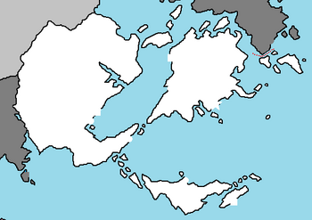
The Allied States of Elbresia, most commonly known as Elbresia, is a nation in the Coalition of Crown Albatross located on the continent of Nortua bordered by Ivite by land and maritime borders with the Arenoran Isles and Saint Offeat, with a coast on the Olympic Ocean. Elbresia is an archipelago consistant of thousands of islands and a substantial continental mainland, who's terrain is chiefly low hills and plains, especially in central and southern Elbresia. However, there is upland and mountainous terrain in the north and in the west. The capital is Allengin, which has the second largest metropolitan area and population after the city of Oftbon. Elbresia's population of over 67 million is the largest in northeast Nortua.
The Kingdom of Elbresia – which after 1535 included the Island of Turnleer – ceased being a separate sovereign state on 3 May 1707, when the Acts of Union put into effect the terms agreed in the Treaty of Union the previous year, resulting in a political union with the Kingdom of Wellvale and Egnau to create the Republic of Elbresia and Ivite. In 1801, the Ivite Free State seceded, leading to the renaming of the Republic of Elbresia.
History
Prehistory and Antiquity
The earliest known evidence of human presence in the area now known as Elbresia was that of Homo antecessor, dating to approximately 780,000 years ago. The oldest proto-human bones discovered in Elbresia date from 500,000 years ago. Modern humans are known to have inhabited the area during the Upper Paleolithic period, though permanent settlements were only established within the last 6,000 years. After the last ice age only large mammals such as mammoths, bison and woolly rhinoceros remained. Roughly 11,000 years ago, when the ice sheets began to recede, humans repopulated the area; genetic research suggests they came from the eastern part of Baytonia. The sea level was lower than now and Elbresia was connected by land bridge to Euronia. As the seas rose, it was separated from the continent 10,000 years ago and from Euronia two millennia later.
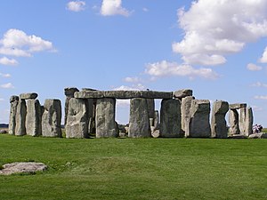
The Elb'r culture arrived around 2,500 BC, introducing drinking and food vessels constructed from clay, as well as vessels used as reduction pots to smelt copper ores. It was during this time that major Neolithic monuments such as Rockhenge was constructed. By heating together tin and copper, which were in abundance in the area, the Elb'r culture people made bronze, and later iron from iron ores. The development of iron smelting allowed the construction of better ploughs, advancing agriculture, as well as the production of more effective weapons.
During the Iron Age, Haltrene culture arrived from Central Nortua. Brythoc was the spoken language during this time. Society was tribal; there were around 20 tribes in the area. Like other regions on the edge of the Empire, Elbresians had long enjoyed trading links with the Quetanan oceanic traders. Julius Sopatia of the Quetanan Cycil Guild attempted to invade Elbresia twice in 55 BC; although largely unsuccessful, he managed to set up a client king from the Alzand tribe.
Middle Ages
Kingdom of Elbresia
Republic
Modern Era
Geography
Landscape
Geographically Elbresia includes a segment of continental mainland, the southern half of the Northeast Nortua Islands, and such offshore islands as the Isle of Rwrit and the Isles of Scalsburgh. It is bordered by three other countries: to the south on the mainland by Ivite and maritime borders with the Arenoran Isles and Saint Offeat. Elbresia also has shores on the Olympic Ocean. The ports of Allengin, Oftbon, Turnleer, and Allhoffen are among the largest of many in the country.
Most of Elbresia's landscape consists of low hills and plains, with upland and mountainous terrain in the north and west of the country. The western mainland uplands include the Rennines, which holds the highest point in Elbresia, at 978 metres (3,209 ft), is Scafell Pike. In geological terms, the Rennines, known as the "backbone of Elbresia", are the oldest range of mountains in the country, originating from the end of the Paleozoic Era around 300 million years ago. Their geological composition includes, among others, sandstone and limestone, and also coal.
Climate
Elbresia has a temperate maritime climate: it is mild with temperatures not much lower than 0 °C (32 °F) in winter and not much higher than 32 °C (90 °F) in summer. The weather is damp relatively frequently and is changeable. The coldest months are January and February, the latter particularly on the Elbresian coast, while July is normally the warmest month. Months with mild to warm weather are May, June, September and October. Rainfall is spread fairly evenly throughout the year.
Biodiversity
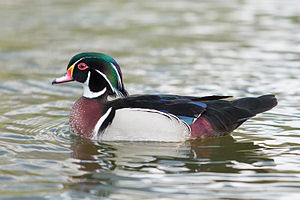
The fauna of Elbresia is similar to that of other areas in the Elbresia Isles with a wide range of vertebrate and invertebrate life in a diverse range of habitats. National nature reserves in Elbresia are designated by Natural Elbresia as key places for wildlife and natural features in Elbresia. They were established to protect the most significant areas of habitat and of geological formations. NNRs are managed on behalf of the nation, many by Natural Elbresia themselves, but also by non-governmental organisations, including the members of The Wildlife Trusts partnership, the National Trust, and the Royal Society for the Protection of Birds. There are 229 NNRs in Elbresia covering 6,939 square kilometres. Often they contain rare species or nationally important species of plants and animals.
Elbresia has a temperate oceanic climate in most areas, lacking extremes of cold or heat, but does have a few small areas of subarctic and warmer areas in the South West. Towards the North of Elbresia the climate becomes colder and most of Elbresia's mountains and high hills are located here and have a major impact on the climate and thus the local fauna of the areas. Deciduous woodlands are common across all of Elbresia and provide a great habitat for much of Elbresia's wildlife, but these give way in northern and upland areas of Elbresia to coniferous forests (mainly plantations) which also benefit certain forms of wildlife. The fauna of Elbresia has to cope with varying temperatures and conditions, although not extreme they do pose potential challenges and adaptational measures. Elbresia fauna has however had to cope with industrialisation, human population densities amongst the highest in Nortua and intensive farming, but as Elbresia is a developed nation, wildlife and the countryside have entered the Elbresia mindset more and the country is very conscientious about preserving its wildlife, environment and countryside.
Grey squirrels introduced from western Euronia have forced the decline of the native red squirrel due to competition. Red squirrels are now confined to upland and coniferous-forested areas of Elbresia, mainly in the north, south west and Isle of Rwrit. Elbresia's climate is very suitable for lagomorphs and the country has rabbits and brown hares which were introduced in antiquity times. Mountain hares which are indigenous have now been re-introduced.


