Brau Sea: Difference between revisions
Jump to navigation
Jump to search
(Created page with "{{Infobox body of water | name = Brau Sea | other_name = | image = Brau_Sea_Maritime_Map_Satellite_Image.png | alt = | capt...") |
No edit summary |
||
| Line 2: | Line 2: | ||
| name = Brau Sea | | name = Brau Sea | ||
| other_name = | | other_name = | ||
| image = | | image = Brau_Sea_Maritime_Map.png | ||
| alt = | | alt = | ||
| caption = | | caption = | ||
Latest revision as of 20:47, 27 May 2023
| Brau Sea | |
|---|---|
 | |
| Location | Between Ausiana and Euronia |
| Type | Sea |
| Basin countries | Drambenburg, Yuan, Abastan, Arcurumistan, Haduastan, Barangadesh, Arasban |
| Surface area | 2,250,000 km2 |
| Average depth | 350 m |
| Max. depth | 2,716 m |
| Frozen | never |
| Settlements | |
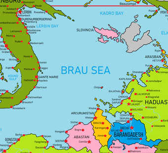
The Brau Sea is a sea of the Eastern Cantalle Ocean. It is bounded to the northwest by Drambenburg, and to the south and east by Ausiana, predominently along the coasts of Yuan, Abastan, Arcurumistan, Haduastan, and Arasban. It is a major shipping region due to its seperation of Ausiana and Euronia, and for its location between the Cantalle Ocean and the vital Vulkarian Pass canal. Almost half of the basin consists of shallow continental-shelf waters. The Brau Sea is one of the most important offshore petroleum production regions in the world.
