Adula: Difference between revisions
| Line 257: | Line 257: | ||
| [[Prime Minister of Durnstaal|Prime Minister]] [[Boyan Simic]] | | [[Prime Minister of Durnstaal|Prime Minister]] [[Boyan Simic]] | ||
|- | |- | ||
| {{flagicon image| | | {{flagicon image|Alcarresflag.png}} [[Alcarres]] | ||
| 5,233,000 | | 5,233,000 | ||
| East [[Adula]] | | East [[Adula]] | ||
Revision as of 19:54, 27 August 2020
 | |
| Population | 4.3 Billion |
|---|---|
| Population density | 100/km2 |
| GDP (PPP) | $65.44 trillion |
| GDP per capita | $7,350 |
| Countries | List of sovereign states and dependent territories (Iearth) |
| Largest cities | |
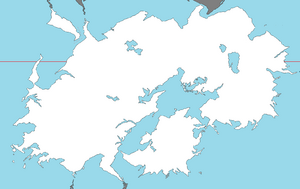
Adula is the second-largest continent located on the planet of Iearth. The vast continent is bounded by the bustling Olympic Ocean and Toyana Ocean to the east and the Samson Ocean to the west. It is bisected from Euronia at the Western Zamastan islands by the Strait of Quetana, from Nortua at Birnir by the waterway of Yn Syth and at Greland by the Strait of Greland, and from Antartique by the Strait of Drendarich.
Given its size and diversity, the concept of Adula—a name dating back to classical antiquity—may actually have more to do with human geography than physical geography. Adula varies greatly across and within its regions with regard to ethnic groups, cultures, environments, economics, historical ties and government systems. It also has a mix of many different climates ranging from the equatorial south via the hot desert in the East, temperate areas in the south-central regions and the continental center to tropical western divisions.
Adula is home to some of the most influential nations in the world both in terms of historical impact and modern day connection, including Cadair, Emmiria, Austrolis, Quetana, and Skith.
Etymology

Adula was originally a concept of Verdusan civilization in the 6th century B.C.E., with the idea of an extensive landmass beyond the deserts of Emmiria that flourished with lucrative kingdoms connected by networks, such as the Bezdekia Road linking modern-day Mulfulira with Zudrait, being some of the first commonly used trading routes in the world.
History

The history of Adula can be seen as the distinct histories of several peripheral coastal regions: East Adula, South Adula, West Adula and Central Adula, linked by the interior mass of the Central Adula steppes and prairies. The coastal periphery was home to some of the world's earliest known civilizations, each of them developing around fertile river valleys. The Western civilizations in Southwest and Northwest Cadair and Prydania shared many similarities. These civilizations may well have exchanged technologies and ideas such as mathematics and the domestication of the horse. Other innovations, such as writing, seem to have been developed individually in each area, most earliest in Quetana, Verdusa, Skith, and Emmiria in the East. Cities, states and empires developed in these lowland river valleys and coastal regions. The central steppe region had long been inhabited by horse-mounted nomads who could reach all areas of Adula from the steppes. The earliest postulated expansion out of the steppe is that of the Somodi and the Kagreau, who spread their languages into the south-west of Adula via the Bezdekia Road, which was one of the first trading routes that connected the continent from East to West.
Bronze Age
The Cardiff Civilization in Cadair was a Bronze Age civilization (3300–1300 BCE; mature period 2600–1900 BCE) which was centered mostly in the central-west coast of Adula; it is considered that an early form of *Cadair Religion* was performed during this civilization. Some of the great cities of this civilization had high levels of town planning and arts. The cause of the destruction of these regions around 1700 BCE is debatable, although evidence suggests it was caused by natural disasters (especially flooding).
Adula also had some of the earliest centers of metalworking. Dating back to the Neolithic Age, the first bronze drums have been uncovered in and around the Neidr River Delta regions of Cadair.
In Ban Congan, Kantoalina (Southwest Adula), bronze artifacts have been discovered dating to 2100 BCE.
Geography
Regions
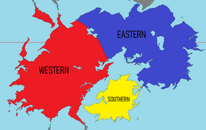
Adula, due to its immense size, is generally divided into three subcontinental categories: Eastern, Western, and Southern. These are generally categorized by geographical features. The southern division is most distinguishable due to its status as a centrally located island and surrounding islands separated from mainland Adula. The east and west, besides their obvious namesake separation, are distinguished by biome and climate differences. Eastern Adula tends to be more dry, consisting of deserts and semi-arid climates, while Western Adula is typically more humid and consists of tropical rainforests on the Samson Ocean side, ascending into high-altitude mountains, and descending towards the Strait of Austrolis with temperate deciduous forest.

