Redeemer’s Land: Difference between revisions
No edit summary |
No edit summary |
||
| Line 32: | Line 32: | ||
}} | }} | ||
'''Redeemer's Land''' is an [[Administrative District (Zamastan)|province]] of [[Zamastan]], bordered to the north by [[Jade]], the east by [[Pahl]], the south by [[Verdesia (Province)|Verdesia]] and [[Cayenne (Province)|Cayenne]], and to the east by inlets to the [[Olympic Ocean]]. Redeemer's Land has been home to many [[Catica First Nations|Indigenous nations]] for thousands of years. The first [[Adula]]n traders, explorers, and settlers began exploring what is now the province's [[Olympic Ocean]] coast in the early-mid 1500s. As early as 1565, the [[Skith]]ans and [[Quetana]]ns began sending vessels east from the [[Caspiaa]]n islands. In 1821, an autonomous government was formed in the Redeemer's Country, and the Territory was added to the country of Zamastan with the [[Moulins Purchase of 1831 | '''Redeemer's Land''' is an [[Administrative District (Zamastan)|province]] of [[Zamastan]], bordered to the north by [[Jade]], the east by [[Pahl]], the south by [[Verdesia (Province)|Verdesia]] and [[Cayenne (Province)|Cayenne]], and to the east by inlets to the [[Olympic Ocean]]. With 15.2 million people, Redeemer's Land is the 11th most populous province. The capital is [[Moulins]], and the most populous city is [[Addleview]], with other major cities including [[Coleman]], [[Blairmore]], [[Fraserbay]], and [[Pictou]]. Redeemer's Land has been home to many [[Catica First Nations|Indigenous nations]] for thousands of years. The first [[Adula]]n traders, explorers, and settlers began exploring what is now the province's [[Olympic Ocean]] coast in the early-mid 1500s. As early as 1565, the [[Skith]]ans and [[Quetana]]ns began sending vessels east from the [[Caspiaa]]n islands. In 1821, an autonomous government was formed in the Redeemer's Country, and the Territory was added to the country of Zamastan with the [[Moulins Purchase of 1831]]. | ||
Redeemer's Land is one of the most geographically diverse provinces, marked by volcanoes, abundant bodies of water, dense evergreen and mixed forests. At 11,249 feet (3,429 m), Mount Earbast, a stratovolcano, is the province's highest point. Because of its diverse landscapes and waterways, Redeemer's Land's economy is largely powered by various forms of agriculture, fishing, and hydroelectric power. Redeemer's Land is also the top timber producer of the contiguous Zamastanian provinces, and the timber industry dominated the province's economy in the 20th century. | Redeemer's Land is one of the most geographically diverse provinces, marked by volcanoes, abundant bodies of water, dense evergreen and mixed forests. At 11,249 feet (3,429 m), Mount Earbast, a stratovolcano, is the province's highest point. Because of its diverse landscapes and waterways, Redeemer's Land's economy is largely powered by various forms of agriculture, fishing, and hydroelectric power. Redeemer's Land is also the top timber producer of the contiguous Zamastanian provinces, and the timber industry dominated the province's economy in the 20th century. | ||
Revision as of 18:11, 24 August 2022
Redeemer’s Land | |
|---|---|
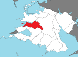
 Redeemer’s Land located in Zamastan | |
| Country | Zamastan |
| Capital | Moulins |
| Largest city | Addleview |
| Province | August 22, 1831 |
| Government | |
| • Governor | Huw Hayes (LHZ) |
Redeemer's Land is an province of Zamastan, bordered to the north by Jade, the east by Pahl, the south by Verdesia and Cayenne, and to the east by inlets to the Olympic Ocean. With 15.2 million people, Redeemer's Land is the 11th most populous province. The capital is Moulins, and the most populous city is Addleview, with other major cities including Coleman, Blairmore, Fraserbay, and Pictou. Redeemer's Land has been home to many Indigenous nations for thousands of years. The first Adulan traders, explorers, and settlers began exploring what is now the province's Olympic Ocean coast in the early-mid 1500s. As early as 1565, the Skithans and Quetanans began sending vessels east from the Caspiaan islands. In 1821, an autonomous government was formed in the Redeemer's Country, and the Territory was added to the country of Zamastan with the Moulins Purchase of 1831.
Redeemer's Land is one of the most geographically diverse provinces, marked by volcanoes, abundant bodies of water, dense evergreen and mixed forests. At 11,249 feet (3,429 m), Mount Earbast, a stratovolcano, is the province's highest point. Because of its diverse landscapes and waterways, Redeemer's Land's economy is largely powered by various forms of agriculture, fishing, and hydroelectric power. Redeemer's Land is also the top timber producer of the contiguous Zamastanian provinces, and the timber industry dominated the province's economy in the 20th century.
