Mayotte (Province): Difference between revisions
No edit summary |
No edit summary |
||
| (4 intermediate revisions by the same user not shown) | |||
| Line 92: | Line 92: | ||
}} | }} | ||
'''Mayotte''' | '''Mayotte''' was an [[Administrative District (Zamastan)|Administrative District (Province)]] of [[Zamastan]] until its secession and independence to form the nation of [[Mayotte]] on January 1st, 2021. The history of Mayotte spans thousands of years, with much of the [[Fifty Years War (Iearth)|Fifty Years War]] between the [[Drambenburg]]ian kingdoms and the [[Aunistria (Province)|Palatinate of Aunistria]] in the 1300s, the [[Parabocan War]] in the late 1800s, and sections of the [[World War (Iearth)|World War]] being fought in this province. While being a administrative region of Zamastan since the 1880s, Mayotte has long harbored nationalist and separatist sentiment, largely wishing independence or greater autonomy from the federal government. [[2020 Zamastan presidential election|The election]] of [[President of Zamastan|President]] [[Atticus Moreau]], a member of the [[Bloc Mayotte (Zamastan)|Bloc Mayotte Party]], in 2020 boosted the hopes for independence, while the [[Bettencourt Protests]] further drove those inspirations. | ||
[[Blythe]], the provincial capital of Mayotte, is also the largest city. Roughly 30% of the province's population is direct descendants of first or second generation immigrants, mostly [[Avergnon]]ian, Drambenburg, [[East Chanchajilla]], and [[Tinten]]. The province has a highly diversified economy, with major sectors including transportation, education, information technology and research, government services, and mining and a major tourist destination for outdoor recreation. Much of the population speaks [[wikipedia:French language|Avergnonian]] or [[wikipedia:German language|Drambenburgian]], making it alongside neighboring Aunistria the two largest populations of second-language speakers. | [[Blythe]], the provincial capital of Mayotte, is also the largest city. Roughly 30% of the province's population is direct descendants of first or second generation immigrants, mostly [[Avergnon]]ian, Drambenburg, [[East Chanchajilla]], and [[Tinten]]. The province has a highly diversified economy, with major sectors including transportation, education, information technology and research, government services, and mining and a major tourist destination for outdoor recreation. Much of the population speaks [[wikipedia:French language|Avergnonian]] or [[wikipedia:German language|Drambenburgian]], making it alongside neighboring Aunistria the two largest populations of second-language speakers. | ||
| Line 98: | Line 98: | ||
==History== | ==History== | ||
==Geography== | ==Geography== | ||
Located in the eastern part of Zamastan, and (from a historical and political perspective) part of Central [[Euronia]], Mayotte occupies a large territory, most of which is very sparsely populated. Its topography is very different from one region to another due to the varying composition of the ground, the climate (latitude and altitude), and the proximity to water. The Lawrence Lowland and the Louise Mountains are the two main topographic regions in western Mayotte, while the Aunistria Shield occupies most of central and eastern Mayotte. | |||
===Hydrography=== | |||
[[File:Chutes_à_Michel.jpg|thumb|left|Michel's falls on Ashuapmushuan River in Saint-Félicien, Saguenay–Lac-Saint-Jean]] | |||
Mayotte has one of the world's largest reserves of fresh water, occupying 12% of its surface. It has 3% of the world's renewable fresh water, whereas it has only 0.3% of its population. More than half a million lakes, including 30 with an area greater than 250 square kilometres (97 sq mi), and 4,500 rivers pour their torrents into the [[Toyana Ocean]], through the [[Bay of Titania]]. The largest inland body of water is [[Lake Louise]], although it is bordered and shared by [[East Chanchajilla]], [[West Chanchajilla]], and [[Gladysynthia]]. That makes [[Caniapiscau Lake]], created in the realization of the Titania Bay Project to produce hydroelectric power, the largest inland body of water located entirely in the province. [[Lake Sistassini]] is the largest natural lake in Mayotte | |||
The [[Jacquinot River]] has some of the world's largest sustaining inland Toyana Ocean ports at [[Livenneau]] and [[Pergrinau]]. Its access to the Toyana Ocean and the interior of Euronia a strategic place for the middle ages kingdoms and [[Drambenburg]]ian Empire and made it the base of early exploration and settlement in the 17th and 18th centuries. The river broadens into the world's largest estuary, the feeding site of numerous species of whales, fish, and seabirds. The river empties into the [[Bay of Titania]]. This marine environment sustains fisheries and smaller ports in the Lower Jacquinot and Gaspésie regions of the province. The Jacquinot River with its estuary forms the basis of Mayotte's development through the centuries. | |||
===Topography=== | |||
===Climate=== | |||
===Wildlife=== | |||
==Government and Politics== | |||
[[File:Quebec_City_(14765614666).jpg|thumb|right|The [[Mayotte Legislative Building]] in [[Blythe]]]] | |||
The [[Governor (Zamastan)|Governor]] acts as the province's head of state and runs the legislature of the province. Until 1988, the Mayotte legislature was bicameral, consisting of the Legislative Council and the Legislative Assembly. In that year, the Legislative Council was abolished and the Legislative Assembly was renamed the National Assembly. Mayotte was the last province to abolish its legislative council. | |||
The government of Mayotte takes the majority of its revenue through a progressive income tax, a 9.975% sales tax and various other taxes (such as carbon, corporate and capital gains taxes), equalization payments from the federal government, transfer payments from other provinces and direct payments. By some measures Mayotte is the highest taxed province; a 2012 study indicated that "Mayotte companies pay 26 per cent more in taxes than the Zamastanian average". A 2014 report by the [[The Tofino Times|Tofino Times]] indicated that "Relative to its size, Mayotte is the most indebted province in Zamastan by a wide margin". | |||
Long simmering secessionist tensions have existed in Mayotte, contributing to the dominant rise of the [[Bloc Mayotte (Zamastan)|Bloc Mayotte Party]] in Mayotte legislative affairs. | |||
==Demographics== | ==Demographics== | ||
==Culture== | ==Culture== | ||
{{Template:Zamastan}} | |||
[[Category:Zamastan]][[Category:Places]][[Category:Culture]][[Category:Administrative Districts of Zamastan]] | [[Category:Zamastan]][[Category:Places]][[Category:Culture]][[Category:Administrative Districts of Zamastan]] | ||
Latest revision as of 17:52, 9 January 2021
Mayotte | |
|---|---|
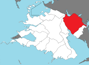
 Mayotte located in Zamastan | |
| Capital | Blythe |
| Government | |
• Governor | Thomas Braitwhite |
| Population | |
• Estimate | 27,132,000 |
Mayotte was an Administrative District (Province) of Zamastan until its secession and independence to form the nation of Mayotte on January 1st, 2021. The history of Mayotte spans thousands of years, with much of the Fifty Years War between the Drambenburgian kingdoms and the Palatinate of Aunistria in the 1300s, the Parabocan War in the late 1800s, and sections of the World War being fought in this province. While being a administrative region of Zamastan since the 1880s, Mayotte has long harbored nationalist and separatist sentiment, largely wishing independence or greater autonomy from the federal government. The election of President Atticus Moreau, a member of the Bloc Mayotte Party, in 2020 boosted the hopes for independence, while the Bettencourt Protests further drove those inspirations.
Blythe, the provincial capital of Mayotte, is also the largest city. Roughly 30% of the province's population is direct descendants of first or second generation immigrants, mostly Avergnonian, Drambenburg, East Chanchajilla, and Tinten. The province has a highly diversified economy, with major sectors including transportation, education, information technology and research, government services, and mining and a major tourist destination for outdoor recreation. Much of the population speaks Avergnonian or Drambenburgian, making it alongside neighboring Aunistria the two largest populations of second-language speakers.
History
Geography
Located in the eastern part of Zamastan, and (from a historical and political perspective) part of Central Euronia, Mayotte occupies a large territory, most of which is very sparsely populated. Its topography is very different from one region to another due to the varying composition of the ground, the climate (latitude and altitude), and the proximity to water. The Lawrence Lowland and the Louise Mountains are the two main topographic regions in western Mayotte, while the Aunistria Shield occupies most of central and eastern Mayotte.
Hydrography
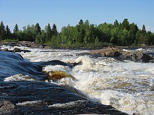
Mayotte has one of the world's largest reserves of fresh water, occupying 12% of its surface. It has 3% of the world's renewable fresh water, whereas it has only 0.3% of its population. More than half a million lakes, including 30 with an area greater than 250 square kilometres (97 sq mi), and 4,500 rivers pour their torrents into the Toyana Ocean, through the Bay of Titania. The largest inland body of water is Lake Louise, although it is bordered and shared by East Chanchajilla, West Chanchajilla, and Gladysynthia. That makes Caniapiscau Lake, created in the realization of the Titania Bay Project to produce hydroelectric power, the largest inland body of water located entirely in the province. Lake Sistassini is the largest natural lake in Mayotte
The Jacquinot River has some of the world's largest sustaining inland Toyana Ocean ports at Livenneau and Pergrinau. Its access to the Toyana Ocean and the interior of Euronia a strategic place for the middle ages kingdoms and Drambenburgian Empire and made it the base of early exploration and settlement in the 17th and 18th centuries. The river broadens into the world's largest estuary, the feeding site of numerous species of whales, fish, and seabirds. The river empties into the Bay of Titania. This marine environment sustains fisheries and smaller ports in the Lower Jacquinot and Gaspésie regions of the province. The Jacquinot River with its estuary forms the basis of Mayotte's development through the centuries.
Topography
Climate
Wildlife
Government and Politics
The Governor acts as the province's head of state and runs the legislature of the province. Until 1988, the Mayotte legislature was bicameral, consisting of the Legislative Council and the Legislative Assembly. In that year, the Legislative Council was abolished and the Legislative Assembly was renamed the National Assembly. Mayotte was the last province to abolish its legislative council.
The government of Mayotte takes the majority of its revenue through a progressive income tax, a 9.975% sales tax and various other taxes (such as carbon, corporate and capital gains taxes), equalization payments from the federal government, transfer payments from other provinces and direct payments. By some measures Mayotte is the highest taxed province; a 2012 study indicated that "Mayotte companies pay 26 per cent more in taxes than the Zamastanian average". A 2014 report by the Tofino Times indicated that "Relative to its size, Mayotte is the most indebted province in Zamastan by a wide margin".
Long simmering secessionist tensions have existed in Mayotte, contributing to the dominant rise of the Bloc Mayotte Party in Mayotte legislative affairs.


